
Order Total (1 Item Items):
Shipping Destination:

Rhode Island Sheet (29 results)
Skip to main search results
Search filters
Product Type
- All Product Types
- Books (23)
- Magazines & Periodicals (No further results match this refinement)
- Comics (No further results match this refinement)
- Sheet Music (2)
- Art, Prints & Posters (1)
- Photographs (No further results match this refinement)
- Maps (3)
- Manuscripts & Paper Collectibles (No further results match this refinement)
Condition Learn more
- New (9)
- As New, Fine or Near Fine (4)
- Very Good or Good (2)
- Fair or Poor (No further results match this refinement)
- As Described (14)
Binding
- All Bindings
- Hardcover (No further results match this refinement)
- Softcover (10)
Collectible Attributes
- First Edition (No further results match this refinement)
- Signed (No further results match this refinement)
- Dust Jacket (No further results match this refinement)
- Seller-Supplied Images (24)
- Not Print on Demand (25)
Language (2)
Free Shipping
Seller Location
Seller Rating
-

Rhode Island Recreation Map & Guide (Sheet Map, Folded)
Language: English
Published by Appalachian Mountain Club 5/21/2019, 2019
ISBN 10: 1628421118 ISBN 13: 9781628421118
Sheet Map, Folded. Condition: New. Rhode Island Recreation Map & Guide. Book.
-

Poor Little Rhode Island (sheet music)
Published by Shapiro, Bernstein & Co., 1944
Seller: A.C. Daniel's Collectable Books, South Paris, ME, U.S.A.
Seller rating 5 out of 5 stars

Sheet Music
Condition: Very Good. Text clean. Spine sound. A nice copy. Sheet Music.
-

-

Condition: As New. Unread book in perfect condition.
-

Condition: New. Preliminary Compilation of the Bedrock Geology of the Land Area of the Boston 2 Degrees Sheet, Massachusetts, Connecticut, Rhode Island and New Hampsh (Paperback or Softback).
-
Single sheet map: Rhode Island (front) and Connecticut (reverse), extracted from a ragged copy of [Hammond's Handy Atlas of the World, C.S. Hammond & Co., 1912]
Language: English
Published by C.S. Hammond & Co., Washington D. C., 1912
No Binding. Condition: Very Good. A single sheet map: Rhode Island (front) and Connecticut (reverse), extracted from a ragged copy of [Hammond's Handy Atlas of the World, C.S. Hammond & Co., 1912]. Depicts major streams, roads, and towns. The paper measures 8 1/8 by 5 7/8 inches with image size of 7 by 4. General age toning, may have soiling, small tears, or pencil notes to margins; image of title page provided for provenance only. Drawer 1.
-

Preliminary compilation of the bedrock geology of the land area of the Boston 2 degrees sheet, Massachusetts, Connecticut, Rhode Island and New Hampsh
Seller: GreatBookPricesUK, Woodford Green, United Kingdom
Seller rating 5 out of 5 stars
US$ 32.29
US$ 19.95 shipping
Ships from United Kingdom to U.S.A.Quantity: Over 20 available
Add to basketCondition: As New. Unread book in perfect condition.
-

Preliminary compilation of the bedrock geology of the land area of the Boston 2 degrees sheet, Massachusetts, Connecticut, Rhode Island and New Hampsh
Seller: GreatBookPricesUK, Woodford Green, United Kingdom
Seller rating 5 out of 5 stars
US$ 40.56
US$ 19.95 shipping
Ships from United Kingdom to U.S.A.Quantity: Over 20 available
Add to basketCondition: New.
-
I'd Rather be at Block Island Than Any Place I Know Sheet Music 1913 Original Empire Theatre Rhode Island
Language: English
Published by Empire Theatre Co, 1913
Sheet Music
Sheet Music. Condition: As New. Empire Theatre Co.; Block Island, 1913. Original sheet music. The Empire Theatre was built in 1882. About 1910, movies were shown on a regular basis, during the great silent era and the building was for the first time called the Empire Theatre. In 1913, the theater even produced a song, a four-page piece of sheet music titled Id Rather Be At Block Island Than Any Place I Know. It was written by James Tammany. The gist, universal appeal, and faultless logic of the lyrics can be appreciated in the opening line: Summers the time that we all like best cause vacation time is here. The Empire persevered through the Roaring 20s, the Depression 30s (when movies were needed most), and the relaxed poverty of the 50s. This is a great and beautiful piece to gift, collect or even frame and hang on the wall as a collectors item. The item is very clean and unmarked, original letterpress production, NOT a reprint or facsimile. 4to[quarto or approx. 9.5 x 12 inches], 5pp only. We pack securely and ship daily with delivery confirmation on every book. The picture on the listing page is of the actual book for sale. Additional Scan(s) are available for any item, please inquire.Please note: Oversized books/sets MAY require additional postage then what is quoted for 2.2lb book.
-

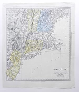
"North America. Sheet VI. New-York, Vermont, Maine, New-Hampshire, Massachusetts, Connecticut, Rhode-Island, and New-Jersey." - New York Connecticut Massachsetts Vermont Jersey United States America Amerika Amerique
Language: English
Published by London, 1832
Seller: Antiquariat Steffen V�lkel GmbH, Seubersdorf, Germany
Seller rating 5 out of 5 stars
Map
Gro�formatige original Stahlstich Karte von 1832 aus dem Atlas: "Maps of the Society for the Diffusion of useful knowledge". - Blattmasse: ca. 41 x 34 cm - gut erhalten. | large sized original steel engraved map from 1832 out of the atlas "Maps of the Society for the diffusion of useful knowledge". - size of sheet: circa 16.1 x 13.4 inches - in good condition. | // Wir, das Antiquariat Steffen V�lkel, kaufen und verkaufen alte B�cher, Handschriften, Zeichnungen, Autographen, Grafiken und Fotografien. Wir sind stets am Ankauf von kompletten Bibliotheken, Sammlungen und Nachl�ssen interessiert. Sprache: Englisch.
-

Condition: New. KlappentextThe United States Geological Survey (USGS) is a scientific organization created in 1879, and is part of the U.S. government. Their scientists explore our environment and ecosystems, to determine the natural dangers we are fac.
-

Rhode Island Sakonnet Sheet
Published by Circa 1885, 1885
Seller: Art Source International Inc., Boulder, CO, U.S.A.
Seller rating 5 out of 5 stars
Art Source International is pleased to offer topographical surveys from the 1884-1888 Atlas of Massachusetts. This finely detailed collection was made by the United States Geological Survey and the Commissioners of the Commonwealth. These maps show the topography of Massachusetts counties and towns, including such features as railroads, buildings, wagon trails, rivers, lakes and ponds. This map measures 13 inches by 17.5 inches.
-

Massachusetts-Connecticut-Rhode Island: Webster Sheet
Published by Circa 1885, 1885
Seller: Art Source International Inc., Boulder, CO, U.S.A.
Seller rating 5 out of 5 stars
Art Source International is pleased to offer topographical surveys from the 1884-1888 Atlas of Massachusetts. This finely detailed collection was made by the United States Geological Survey and the Commissioners of the Commonwealth. These maps show the topography of Massachusetts counties and towns, including such features as railroads, buildings, wagon trails, rivers, lakes and ponds. This map measures 13 inches by 17.5 inches.
-

Condition: New. Print on Demand pp. 146.
-

Massachusetts-Rhode Island-Providence Sheet
Published by Circa 1885, 1885
Seller: Art Source International Inc., Boulder, CO, U.S.A.
Seller rating 5 out of 5 stars
Art Source International is pleased to offer topographical surveys from the 1884-1888 Atlas of Massachusetts. This finely detailed collection was made by the United States Geological Survey and the Commissioners of the Commonwealth. These maps show the topography of Massachusetts counties and towns, including such features as railroads, buildings, wagon trails, rivers, lakes and ponds. This map measures 13 inches by 17.5 inches.
-
Condition: New. Print on Demand pp. 146.
-
Condition: New. PRINT ON DEMAND pp. 146.
-

North America Sheet VI New York, Vermont, Maine, New Hampshire, Massachusetts, Connecticut, Rhode Island, and New Jersey. SDUK (Society for the diffusion of useful knowledge) North America Sheet VI New York, Vermont, Maine, New Ha. Antique Map, Steel Engraving 352 x 312m.
Published by Baldwin & Cradock, London, 1832
Seller: Antiquariat Reinhold Berg eK Inh. R.Berg, Regensburg, Germany
Seller rating 5 out of 5 stars
Map
Other. Steel Engraving, hand-colored in outline by SDUK (Society for the diffusion of useful knowledge), published 1832 by Baldwin & Cradock, London. Image size: 352 by 312mm (13 by 12 inches). From the celebrated SDUK series widely regarded as among the finest steel-engraved maps of the 19th century. The Society for the Diffusion of Useful Knowledge (SDUK) was a Whig organization founded in London in 1826 with the admirable goal of making information accessible to the working and middle classes. Its map committee began publishing in 1829, producing a celebrated series of finely engraved steel maps initially under the Baldwin & Cradock imprint, later reissued by Chapman & Hall (from 1844) and Charles Knight. The SDUK maps are renowned for their exceptional precision, elegant typography, and fine steel engraving widely considered among the finest examples of British cartography from the first half of the 19th century. Their North American sheets were produced at a transformative moment in the continent's history, making them invaluable historical documents as well as beautiful collector objects.This North America map shows the east coast from New Jersey to Maine. The individual states are painted beautifully in outline color. The title is engraved in the lower right corner. In excellent condition. 352 by 312mm (13 by 12 inches). In excellent condition. 352 by 312mm (13 by 12 inches). 352 by 312mm (13 by 12 inches).
-

CONNECTICUT - RHODE ISLAND PUTNAM SHEET
Publication Date: 1893
Seller: Art Source International Inc., Boulder, CO, U.S.A.
Seller rating 5 out of 5 stars
We are thrilled to offer this map originally issued as part of the Topographical Atlas of the State of Connecticut, 1893, issued by the United States Geological Survey, J.W. Powell, Director. We noticed the inscription by The State Librarian, Connecticut, that there were 100 copies made. This is the only time we have seen these maps in our 30 years of collecting. This map measures 13.25 inches by 17.5 inches.
-

NORTH AMERICA SHEET VI NEW-YORK, VERMONT, MAINE, NEW-HAMPSHIRE, MASSACHUSETTS, CONNECTICUT, RHODE-ISLAND, AND NEW-JERSEY.
Published by Atlas for the Society for the Diffusion of Useful Knowledge. Charles Knight & Co. c.1840, 1840
Seller: Peter Harrington. ABA/ ILAB., London, United Kingdom
Association Member: ABA ILAB PBFA
Seller rating 5 out of 5 stars
US$ 164.39
US$ 29.26 shipping
Ships from United Kingdom to U.S.A.Quantity: 1 available
Add to basketA detailed map showing Railways, Projected Railways, Canals and Roads. Scale in right hand margin. Steel engraving. In fine condition. Original colour. Size: 31.3 x 34.9 cm. (12� x 13� inches).
-
North America Sheet VI. New-York, Vermont, Maine, New-Hampshire, Massachusetts, Connecticut, Rhode-Island, and New-Jersey.
Published by London, Baldwin & Cradock, 1832
Seller: Buch- und Kunst-Antiquariat Flotow GmbH, Ottobrunn, Germany
Seller rating 5 out of 5 stars
41 x 34,5 cm (Blattgr��e). In sauberer Erhaltung Original-kolorierte Stahlstich-Karte aus J. B. C. Walker, North America.
-

Map of North America, Sheet 6, New York, Vermont, Maine, New Hampshire, Massachusetts, Connecticut, Rhode Island, and New Jersey
Published by London, 1857
Seller: Trillium Antique Prints & Rare Books, Franklin, TN, U.S.A.
Seller rating 2 out of 5 stars

Art / Print / Poster
Condition: Fine. This originally hand-colored engraving is from "The Complete Atlas of Modern, Classical and Celestial Maps, together with Plans of the Principal Cities of the World". The work was published in 1857 by Edward Stanford for the Society for the Diffusion of Useful Knowledge. --- The work is in very good to excellent condition. There may be a few minor imperfections to be expected with age. Please review the image carefully for condition and contact us with any questions. --- Paper Size ~ 14" by 16 7/8".
-
Preliminary Compilation of the Bedrock Geology of the Land Area of the Boston 2 Degrees Sheet, Massachusetts, Connecticut, Rhode Island and New Hampshire: Usgs Open-File Report 77-285
Seller: THE SAINT BOOKSTORE, Southport, United Kingdom
Seller rating 5 out of 5 stars
US$ 46.02
US$ 16.81 shipping
Ships from United Kingdom to U.S.A.Quantity: Over 20 available
Add to basketPaperback / softback. Condition: New. This item is printed on demand. New copy - Usually dispatched within 5-9 working days.
-

Rhode Island, Sheet No. 1
Publication Date: 1891
Seller: Art Source International Inc., Boulder, CO, U.S.A.
Seller rating 5 out of 5 stars
A very detailed contour map of Rhode Island including the towns of CUMBERLAND, NORTH SMITHFIELD, JOHNSTON, SCITUATE, CRANSTON, PAWTUCKET, and PROVIDENCE This highly informative map pays particular attention to major building, railroads and mills. This map measures 14.5 inches by 20 inches.
-

Rhode Island, Sheet No. 5
Publication Date: 1891
Seller: Art Source International Inc., Boulder, CO, U.S.A.
Seller rating 5 out of 5 stars
A very detailed contour map of Rhode Island including the towns of HOPKINTON, RICHMOND, GREENWICH, EXETER, COVENTRY, SCITUATE, and FOSTER. This highly informative map pays particular attention to major buildings, railroads and mills. This map measures 15 inches by 20 inches.
-

Rhode Island, Sheet No. 2
Publication Date: 1891
Seller: Art Source International Inc., Boulder, CO, U.S.A.
Seller rating 5 out of 5 stars
A very detailed contour map of Rhode Island including the towns of BURRILLVILLE, GLOCESTER, FOSTER, SCITUATE, GRANITEVILLE, and HARRISVILLE. This highly informative map pays particular attention to major buildings, railroads and mills. This map measures 14.5 inches by 20 inches.
-

USA- MAP New England Title: North America sheet VI. New-York, Vermont, Maine, New-Hampshire, Massachusetts, Connecticut, Rhode-Island, and New-Jersey.
Published by Baldwin & Cradock, London, 1832
Seller: ANTIQUARIAT.WIEN Fine Books & Prints, Wien, Austria
Seller rating 5 out of 5 stars
Map
Engraved Map by J. & C. Walker., grenzkoloriert, Gebirge mit Schraffen, Titel unten rechts, Ma�stab Mitte Rechts , 30 x 33,5 cm Tooley I, 77 / antike originale Landkarte, antique original map de 500 Landkarte.
-

Rhode Island, Sheet No. 4
Publication Date: 1891
Seller: Art Source International Inc., Boulder, CO, U.S.A.
Seller rating 5 out of 5 stars
A very detailed contour map of Rhode Island including the towns of WARWICK KINGSTOWN, EXETER, NARRAGANSETT, PROVIDENCE, COVENTRY, CRANSTON, and CHEPIWANOXET ISLAND This highly informative map pays particular attention to major buildings, railroads and mills. This map measures 14.5 inches by 20.5 inches.
-

Rhode Island, Sheet No. 8
Publication Date: 1891
Seller: Art Source International Inc., Boulder, CO, U.S.A.
Seller rating 5 out of 5 stars
A very detailed contour map of Rhode Island including the towns of EXETER, RICHMOND, CHARLESTOWN, KINGSTON, and NARRAGANSETT This highly informative map pays particular attention to major buildings, railroads and mills. This map measures 14.5 inches by 20.5 inches.

![Seller image for Single sheet map: Rhode Island (front) and Connecticut (reverse), extracted from a ragged copy of [Hammond's Handy Atlas of the World, C.S. Hammond & Co., 1912] for sale by TribalBooks](https://pictures.abebooks.com/inventory/md/md30839709887.jpg)
