Order Total (1 Item Items):
Shipping Destination:

Underground Map Number (8 results)
Skip to main search results
Search filters
Product Type
- All Product Types
- Books (3)
- Magazines & Periodicals (No further results match this refinement)
- Comics (No further results match this refinement)
- Sheet Music (No further results match this refinement)
- Art, Prints & Posters (No further results match this refinement)
- Photographs (No further results match this refinement)
- Maps (4)
- Manuscripts & Paper Collectibles (1)
Condition Learn more
- New (No further results match this refinement)
- As New, Fine or Near Fine (No further results match this refinement)
- Very Good or Good (3)
- Fair or Poor (1)
- As Described (4)
Binding
- All Bindings
- Hardcover (No further results match this refinement)
- Softcover (4)
Collectible Attributes
- First Edition (No further results match this refinement)
- Signed (No further results match this refinement)
- Dust Jacket (No further results match this refinement)
- Seller-Supplied Images (7)
- Not Print on Demand (8)
Language (2)
Free Shipping
- Free Shipping to U.S.A. (No further results match this refinement)
Seller Location
Seller Rating
-

Paperback. Condition: Poor. READ THIS!!!! A VERY WORN COPY. Three four inch tears neatly along folds, vertical folds all tape reinforced, some various tiny to small chips usually along folds. still quite readable but very fragile. Photos on request.
-
US$ 44.21
US$ 26.83 shipping
Ships from United Kingdom to U.S.A.Quantity: 1 available
Add to basketGood paperback (light edgewear, externally grubby, map is clean and unmarked however there are a few closed tears along some of the folds). Fold-out map. The image on this page is of the actual item for sale.
-
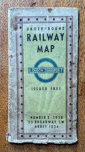
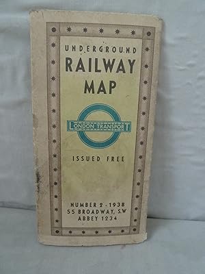
UNDERGROUND RAILWAY MAP. London Transport. Issued Free. Number 1 - 1937.
Language: English
Published by London Transport, London, 1937
Map
US$ 82.90
US$ 28.17 shipping
Ships from United Kingdom to U.S.A.Quantity: 1 available
Add to basketNo Binding. Condition: Very Good. Folding map 45x60.5cm, verso with two smaller maps - one indicating locations of listed art galleries & museums, buildings & public halls, and cathedrals & churches, the other indicating locations of listed theatres & cinemas. Printed by the Baynard Press. The whole folding up to 15x8cm. A little wear, with negligible loss, at intersections of a few folds. Clean and unmarked. VERY GOOD condition.
-
US$ 55.27
US$ 26.83 shipping
Ships from United Kingdom to U.S.A.Quantity: 1 available
Add to basketSoft cover. Condition: Good. vintage fold out paper map that shows the Underground in diagramatic form just prior to WW2. Lines shown are the Metropolitan & District, Picadilly, Bakerloo, Northern and Central. Catchment are covered includes Staines to the West, Hight Barnet to the North , Upney to the East and Mordon to the South. Rear shows blow up to central brown area, also map of theatres and cinemas.Condition: has a few large tears but not taped . Top margin has small stains but does not impinge on map. Would still look fantastic as a wall hanging.
-
London Transport Underground Map Number 1 1939
Published by London Transport, London, 1939
Seller: 32.1 Rare Books + Ephemera, IOBA, ESA, Princeton, NJ, U.S.A.
Association Member: IOBA
Seller rating 4 out of 5 stars

Manuscript / Paper Collectible
Softcover. 3" x 5" multipanel map folding out to 23 1/2" x 17 1/4." Designed by Geographia and printed by the Baynard Press. It shows the routes of London Underground in a geographical layout, and not in the diagrammatic 'Beck' format used for the smaller pocket maps from 1933. This map was produced just before the beginning of the Second World War and used a design that had already been in use for a number of years. **OCLC** lists no holdings of the 1939 map and one holding of the 1938 edition. Very Good. Crisp with folds and a few tiny holes at some corners.
-
Underground Railway Map. London Transport. Number 1, 1937
Published by London Transport, London, 1937
Seller: Antipodean Books, Maps & Prints, ABAA, Garrison, NY, U.S.A.
Association Member: ABAA ANZAAB ESA ILAB
Seller rating 3 out of 5 stars

Condition: Very good condition. Scarce folding color original London Underground map, which includes 2 other maps of important London sites. With the three cover panels offering information on fares, and listing dominion offices and consulates, with the the flip side with a map showing theatres and cinemas in relation to the underground lines, in red and blue stars, and lists of art galleries, museums, public halls, and churches and cathedrals. The Tube map extends from Cockfosters in the north, to Morden in the south; Becontree in the east and Uxbridge in the west. Authorized extensions are shown in dotted red lines. Unfolds to 18 x 24"; 3 x 6" folded. Very good + condition, very clean, with the colors on maps bright and fresh.
-
Underground Map. Number 2. 1939.
Published by London Transport, 1939., 1939
Seller: Michael S. Kemp, Bookseller, Sheerness, KENT, United Kingdom
Association Member: PBFA
Seller rating 5 out of 5 stars

Map
US$ 54.17
US$ 53.66 shipping
Ships from United Kingdom to U.S.A.Quantity: 1 available
Add to basket450 x 605 mm. colour printed map with detailed map of the central area and keys to verso. Folded to pocket size with a some splitting to the folds as usual, and slight soiling to the outer panels.
-
![Seller image for [Plan of the London Underground]. Underground Map Number 3. for sale by Robert Frew Ltd. ABA ILAB](https://pictures.abebooks.com/inventory/md/md32429737238.jpg)
[Plan of the London Underground]. Underground Map Number 3.
Published by LondonGeographia Ltd ., 1939
Seller: Robert Frew Ltd. ABA ILAB, London, United Kingdom
Association Member: ABA ILAB PBFA
Seller rating 5 out of 5 stars
Map
US$ 138.17
US$ 13.41 shipping
Ships from United Kingdom to U.S.A.Quantity: 1 available
Add to basketOriginal colour-printed plan of the London Underground (overall size: 60.5 x 44.5 cm) with multiple folds reducing to a single pamphlet as issued. The map has a coloured background with the underground lines imposed over a street plan of central London and adjacent suburbs. Underground stations are denoted by circles and interchange stations are denoted by a diamond. Public parks are highlighted in green, and in the lower right corner there is a table showing the colour-coded key to the underground lines, along with a dotted-line for lines (Central, Bakerloo, Northern) listed for further construction in the future. The map runs from Uxbridge in the west, to Cockfosters and High Barnett in the north, to Morden in the south, and Barking in the east. On the reverse is a small plan showing centrally located cinemas and theatres, plus a larger plan showing central London overlaid with underground lines and symbols depicting art galleries, public buildings of note, cathedrals and churches. Complete with an explanation table. Lists accompany the plan for easy reference, including 'Future Extensions' to the Underground. In very good condition.