Waldeck Comitatus (50 results)

Seller: LIBRERIA IL TEMPO CHE FU, Enna, EN, ItalyLIBRERIA IL TEMPO CHE FU
Contact seller5-star sellerCondition: Used - Fine
US$ 25.32
US$ 9.67 shippingShips from Italy to U.S.A.Quantity: 1 available
Condition: Ottimo. Rara e grande ristampa dei primi '900 Stampata su carta speciale Carta geografica o Mappa Waldeck Comitatus Anno 1650 Dimensioni: Cm 55,00 x 40,00 Codice prodotto: Litografie - 1301 Qualora vogliate delle scansioni migliori contattateci, soddisferemo ogni vostra richiesta. Paypal Carta di credito Bonifico banc…ario Accuratamente adagiate su un cartoncino e protette da pellicola trasparente rigida, il tutto viene inserito dentro plico di adeguate dimensioni per proteggerne l'integrità. Litografie-1301.
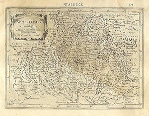
Published by AmsterdamJansson. 1634
- Map
Seller: Robert Frew Ltd. ABA ILAB, London, , United KingdomRobert Frew Ltd. ABA ILAB
Contact seller5-star sellerCondition: Used
US$ 54.38
US$ 13.20 shippingShips from United Kingdom to U.S.A.Quantity: 1 available
14.2 x 19.3 cm. Uncoloured. Single page map of the region surrounding Waldeck, northern Hessen. Latin text on verso. Light dampstain across upper and right edges of sheet.

Language: French
Published by Amsterdam, Hondius c. 1606. 1606
- Map
Seller: Antiquariat Steffen Völkel GmbH, Seubersdorf, GermanyAntiquariat Steffen Völkel GmbH
Contact seller5-star sellerCondition: Used
US$ 93.76
US$ 34.14 shippingShips from Germany to U.S.A.Quantity: 1 available
Rare map with original color from a French edition of Mercator's Atlas Major. -- With rare original color, no modern coloring! With French text on verso. -- in very good condition. || Seltene Karte mit originalem Altkolorit aus einer französischen Ausgabe von Mercator's Atlas Major. -- Maß: c. 36 x 46 cm. -- Kein modernes Kolori…t! Mit französischem Text auf der Rückseite. -- gut erhalten. || Dies ist ein Original! - Kein Nachdruck! - Keine Kopie! -- This is an original! - No copy! - No reprint! // Wir, das Antiquariat Steffen Völkel, kaufen und verkaufen alte Bücher, Handschriften, Zeichnungen, Autographen, Grafiken und Fotografien. Wir sind stets am Ankauf von kompletten Bibliotheken, Sammlungen und Nachlässen interessiert. Sprache: Französisch Gewicht in Gramm: 550.

Language: German
Published by Selbstverlag, Antwerpen 1579
- Softcover
- Map
Seller: Antiquariat und Verlag Gerhard Henrich, Langenbieber, GermanyAntiquariat und Verlag Gerhard Henrich
Contact seller5-star sellerCondition: Used - Very good
US$ 70.33
US$ 91.04 shippingShips from Germany to U.S.A.Quantity: 1 available
Softcover. Condition: Gut. Dekorative kolorierte Karte im Format 31,5 x 22 cm auf Bütten im Format 43,5 x 26 cm, links etwas knapp (2 mm) beschnitten.

Language: Latin
Published by Nürnberg ca. 1720. 1720
- Map
Seller: Antiquariat Steffen Völkel GmbH, Seubersdorf, GermanyAntiquariat Steffen Völkel GmbH
Contact seller5-star sellerCondition: Used
US$ 58.60
US$ 34.14 shippingShips from Germany to U.S.A.Quantity: 1 available
Original altkolorierte Kupferstich-Karte von ca. 1720. -- Blatt-Maße: ca. 53,5 x 61 cm. -- in den Rändern teils etwas fleckig, im unteren Mittelbug teils hinterlegt, sonst gut erhalten. || Original old colored engraved map from ca. 1720. -- partly stained on the margins, partly deposited on the lower part of the centerfold, othe…rwise in good condition. // Wir, das Antiquariat Steffen Völkel, kaufen und verkaufen alte Bücher, Handschriften, Zeichnungen, Autographen, Grafiken und Fotografien. Wir sind stets am Ankauf von kompletten Bibliotheken, Sammlungen und Nachlässen interessiert. la Gewicht in Gramm: 30.
Published by Amsterdam, Hondius, um 1610. 1610
- Art Print
Seller: Antiquariat Thomas Rezek, München, GermanyAntiquariat Thomas Rezek
Contact seller5-star sellerCondition: Used
US$ 79.70
US$ 50.07 shippingShips from Germany to U.S.A.Quantity: 1 available
circa 43 x 55 cm. 1 Doppelblatt verso französischer Text (Le comte de Waldeck?) Oben links Krtusche, unten Meilenzeiger, mit Korbach, Bad Arolsen, Volksmarsen, Wildungen etc., oben Teil der Gegend um Paderborn. - Mittelfalte hinterlegt, angesetzt (ohne Verlust), kaum angstaubt, wenig fleckig in den Rändern, leicht knittrig, gut…erhalten meist sauber und schöner Gesamteindruck.
Published by Nürnberg [um 1730],
Seller: Antiquariat Cellensia, Celle, , GermanyAntiquariat Cellensia
Contact seller3-star sellerCondition: Used
US$ 70.33
US$ 68.28 shippingShips from Germany to U.S.A.Quantity: 1 available
Altkolorierter Kupferstich. 48,5 x 57,5 cm. 2 dekorativen Kartuschen. Zeigt auch die Grafschaft Waldeck, sowie im Osten das Eichsfeld. Ränder leicht gebräunt. Guter Zustand.
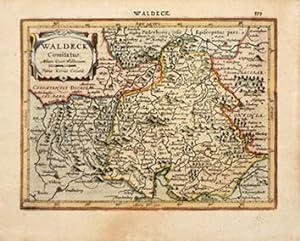
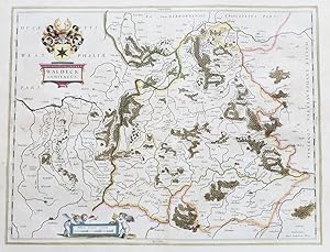
Published by Atlas Minor. Jan Jansson the Elder. 1628, Latin edition. 1628
Seller: Peter Harrington. ABA/ ILAB., London, United KingdomPeter Harrington. ABA/ ILAB.
Contact seller5-star sellerCondition: Used
US$ 129.16
US$ 29.04 shippingShips from United Kingdom to U.S.A.Quantity: 1 available
In 1604 Hondius bought the plates of Gerard Mercator's atlas, added about 40 maps to Mercator's original number, and from 1606 published enlarged editions in many languages still under Mercator's name, but with his own name as publisher. These atlases have become known as the Mercator/Hondius series. The following year the maps…were re-engraved in miniature form and issued as a pocket Atlas Minor. Bannister/Moreland - Antique Maps pp. 97 & 102. Copper engraving. In fine condition. Later colour. Size: 19 x 12 cm. (7½ x 4½ inches).
 More images
Published by Amsterdam 1640
Seller: Antiquariat Kastanienhof, Pirna, GermanyAntiquariat Kastanienhof
Contact seller5-star sellerCondition: Used - Very good
US$ 90.25
US$ 69.99 shippingShips from Germany to U.S.A.Quantity: 1 available
Kein Einband. Condition: Gut. 38,2 x 50 cm gefaltete Landkarte, mit Mittelfalz, Papier altersbedingt etwas gebräunt, sonst GUTES EXEMPLAR---Mit lateinischem Rückseitentext. Blatt: 44 x 55,2 cm Für Ihre Zufriedenheit versenden wir mit DHL und ausschließlich mit Trackingcode für eine sichere Sendungsverfolgung! Weitere Angebote un…ter antiquariat-kastanienhof , 1 Seiten. nein.

Published by I.E. Cloppenburgh, Amsterdam 1630
- Map
Seller: Antiquariat Reinhold Berg eK Inh. R.Berg, Regensburg, , GermanyAntiquariat Reinhold Berg eK Inh. R.Berg
Contact seller5-star sellerCondition: Used
US$ 169.96
US$ 27.31 shippingShips from Germany to U.S.A.Quantity: 1 available
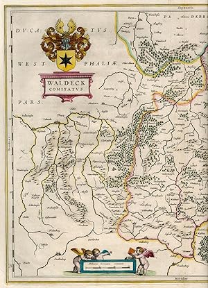
Other. Hand-Colored Original Copperplate Engraving by Gerard Mercator, depicting Waldeck Comitatus. Published Amsterdam, I.E. Cloppenburgh, 1630. Sheet: 180 by 248mm (7 by 9 inches). A fine and original hand-colored example of Mercator's celebrated cartographic work, documenting this region of Germany with the precision and deco…rative artistry characteristic of the 16300s. Gerardus Mercator (1512-1594) was the greatest cartographer of the 16th century. Born in Flanders, he invented the Mercator projection in 1569 -- a revolutionary cylindrical map projection still used in nautical charts today. He was the first to use the word 'atlas' for a collection of maps, honouring the Titan who held up the world. His 1585 atlas of France, Germany, and the Low Countries was the first in a series that would be completed and republished by his heirs and successors, most notably Hondius and Janssonius. Mercator maps are prized by collectors for their historical importance and elegant Renaissance engraving, and are held in leading institutions including the BibliothËque nationale de France and the British Library.This original copperplate engraving, with original hand coloring depicts the region of Waldeck Comitatus., published in Amsterdam, I.E. Cloppenburgh, 1630. The map records the political and geographic boundaries of the region as understood in 1630, offering a fascinating window into the history of German territorial organization. Sheet measures 180 by 248mm (7 by 9 inches). In good condition overall, with minor signs of age appropriate for a 17th-century engraving. Ready to frame. Koeman, ME 198 In excellent condition. 180 by 248mm (7 by 9 inches). 180 by 248mm (7 by 9 inches).

Published by Amsterdam: Henri Du Sauzet [nach ] 1737
- Art Print
Seller: Antiquariat Tautenhahn, Lübeck, , GermanyAntiquariat Tautenhahn
Contact seller5-star sellerCondition: Used
US$ 117.21
US$ 119.49 shippingShips from Germany to U.S.A.Quantity: 1 available
Kupferstich 16 x 22,5 cm, Blattgröße 23 x 34,5 cm. Die Landkarte zeigt das Gebiet Waldeck in Hessen. Am oberen Bildrand Paderbornensis Episcopatus pars, links Coloniensis Dioecesis Pars. Oben links die Titelkartusche mit einem Meilenanzeiger und dem Namen Mercator. Am unteren Bildrand Petrus Kaerius Caelavit. - Aus: Atlas Portat…if Composé de CCLXXXV Cartes. - Sauberes Blatt in kraftvollem Druck.
Published by Nürnberg, ca., . 1720
Seller: Werner Engelmann, Lahr, BW, GermanyWerner Engelmann
Contact seller5-star sellerCondition: Used
US$ 234.43
US$ 22.76 shippingShips from Germany to U.S.A.Quantity: 1 available
Gebiet: Herborn - Paderborn, Smalkalden - Elmbecke 47 x 56 cm kräftiger Abdruck, einmal gefaltet.

Published by Nürnberg: Homann um 1720
- Art Print
Seller: Antiquariat Tautenhahn, Lübeck, , GermanyAntiquariat Tautenhahn
Contact seller5-star sellerCondition: Used
US$ 187.54
US$ 119.49 shippingShips from Germany to U.S.A.Quantity: 1 available
Altkolorierter Kupferstich 48,5 x 57,5 cm, Blattgröße 54 x 59,5 cm. Die Karte in altem Flächenkolorit zeigt mittig Kassel, im Norden Oldendorff und im Süden Fulda. In der linken oberen Ecke eine große Kartusche mit dem Titel, einem Wappen und lebhafter figürlicher Staffage. In der rechten oberen Ecke ein Meilenanzeiger mit mytho…logischer Szene.- Johann Baptiste Homann 1663 - 1724, Kupferstecher und Verleger in Nürnberg. - Das Papier im Bereich des ehemaligen Passepartoutausschnittes leicht gebräunt. Im Mittelfalz zwei Stellen beschabt. Leuchtendes Altkolorit.

Published by Amsterdam: Blaeu [um ] 1635
- Art Print
Seller: Antiquariat Tautenhahn, Lübeck, , GermanyAntiquariat Tautenhahn
Contact seller5-star sellerCondition: Used
US$ 328.20
US$ 119.49 shippingShips from Germany to U.S.A.Quantity: 1 available
Grenzkolorierter Kupferstich 38 x 50 cm, Blattgröße 51 x 60,5 cm. Die Kupferstichkarte zeigt mittig das Gebiet von Waldeck, in der linken oberen Ecke die Titelkartusche, darüber ein dekoratives Wappen. Unten links in einer kleinen, von Putti gehaltenen Kartusche ein Meilenanzeiger. Im Bild unten rechts: Amsterdami Apud Guiljemum… Blaeu. Die Grenzen, größere Waldgebiete und die größeren Städte koloriert. - Blaeu, Willem (d.i. Guiljelmum) 1571-1638, Kartograph und Verleger, Herausgeber von Theatre du monde. Seine Söhne setzten seine Arbeit fort. - Im Bereich des ehemaligen Passepartoutausschnittes leicht gebräunt. Schönes, breitrandiges Exemplar.

Published by Artist: Mercator Gerhard ( - 1594 ) Duisburg ca : 1595 1512
Seller: Antique Sommer& Sapunaru KG, München, , GermanyAntique Sommer& Sapunaru KG
Contact seller4-star sellerCondition: Used
US$ 445.41
US$ 51.21 shippingShips from Germany to U.S.A.Quantity: 1 available
Technic: Copper print, colorit: original colored, condition: Restoration at centerfold, size (in cm): 36 x 46 cm, Map shows the surroundings of Waldeck in Hesse with a mileage scale and title cartouche.

Published by Artist: Blaeu Willem Janszoon ( - 1638 ) Amsterdam ca : 1640 1571
Seller: Antique Sommer& Sapunaru KG, München, , GermanyAntique Sommer& Sapunaru KG
Contact seller4-star sellerCondition: Used
US$ 515.74
US$ 51.21 shippingShips from Germany to U.S.A.Quantity: 1 available
Technic: Copper print, colorit: colored, condition: Very good, size (in cm): 38 x 50 cm, Map shows the surroundings of Waldeck in Hesse with a mileage indicator cartouche and title cartouche with the coat of arms of Waldeck.
Language: Latin
Published by Amsterdam ca. 1640. 1640
- Map
Seller: Antiquariat Steffen Völkel GmbH, Seubersdorf, GermanyAntiquariat Steffen Völkel GmbH
Contact seller5-star sellerCondition: Used
US$ 117.20
US$ 34.14 shippingShips from Germany to U.S.A.Quantity: 1 available
Große altkolorierte Kupferstich-Karte von ca. 1640. -- Mit lateinischem Text auf der Rückseite. -- Blatt-Maße: ca. 49,5 x 59 cm. -- gut erhalten. || Large old colored map from c. 1640. With Latin text on verso. -- in good condition. || Dies ist ein Original! - Kein Nachdruck! - Keine Kopie! -- This is an original! - No copy! - N…o reprint! // Wir, das Antiquariat Steffen Völkel, kaufen und verkaufen alte Bücher, Handschriften, Zeichnungen, Autographen, Grafiken und Fotografien. Wir sind stets am Ankauf von kompletten Bibliotheken, Sammlungen und Nachlässen interessiert. la.
Language: German
Published by Nürnberg, [ca. ] 1720
- Map
Seller: Antiquariat Reinhold Pabel, Hamburg, , GermanyAntiquariat Reinhold Pabel
Contact seller5-star sellerCondition: Used
US$ 117.21
US$ 45.52 shippingShips from Germany to U.S.A.Quantity: 1 available
Nürnberg, [ca. 1720]. Darstellung: 48,5 x 57,5 cm. Unter altem Schrägschnittpassepartout. Landkarte von Nordhessen u. Waldeck in altem Grenz- u. Flächenkolorit. Links oben Titelkartusche mit Wappen u. Putti; die Kartusche rechts oben: eine Jagdszene mit Hirsch in bewaldetem Mittelgebirge. Mit dem bekannten Mittelfalz. - Papierve…rlust an linker u. rechter unterer Ecke durch Feuchtigkeitseinwirkung, kurzer Einriss im unteren Falz hinterlegt; unter der Presse entstandene Quetschfalte im rechten Bildteil. Dank des kräftigen, scharfgratigen Abdrucks noch immer beeindruckendes Kartenbild.

Language: Latin
Published by Amsterdam ca. 1700. 1700
- Map
Seller: Antiquariat Steffen Völkel GmbH, Seubersdorf, GermanyAntiquariat Steffen Völkel GmbH
Contact seller5-star sellerCondition: Used
US$ 152.37
US$ 34.14 shippingShips from Germany to U.S.A.Quantity: 1 available
Altkolorierte Kupferstich-Karte von ca. 1700. -- Blatt-Maße: ca. 53 x 61 cm. -- gut erhalten. || Old colored engraved map from ca. 1700. -- in good condition. // Wir, das Antiquariat Steffen Völkel, kaufen und verkaufen alte Bücher, Handschriften, Zeichnungen, Autographen, Grafiken und Fotografien. Wir sind stets am Ankauf von k…ompletten Bibliotheken, Sammlungen und Nachlässen interessiert. la Gewicht in Gramm: 550.

Language: German
Published by Nürnberg, farbkollorierter Kupferstich 1720
- Map
Seller: Antiquariat im Schloss, Schwaigern, D, GermanyAntiquariat im Schloss
Contact seller5-star sellerCondition: Used
US$ 193.40
US$ 39.83 shippingShips from Germany to U.S.A.Quantity: 1 available
Bildgröße 48,7 x 56,9 cm. Kräftiger Druck. Oben knapp beschnitten, jedoch ohne Bild verlußt. Grosse Wappenkartusche (oben links) mit 21 Wappen. Unten rechts eine Kartusche mit Legende, Meilenzeiger, 2 Puteni und (wohl) Hopfenranken. (Foto von dem eingerahmten Blatt, ¤ 380,-) Sprache: Deutsch Gewicht in Gramm: 900.

Seller: LIBROS CON HISTORIA, URROZ-VILLA, NA, SpainLIBROS CON HISTORIA
Contact seller4-star sellerCondition: Used
US$ 93.77
US$ 31.86 shippingShips from Spain to U.S.A.Quantity: 1 available
s.a. MAPA ANTIGUO: "WALDECK Comitatus. Per Gerardum Mercator". Cloppenburg / Janssonius van Waesberghe. Amsterdam 1673 1 hoja. Hoja apaisada de 27x20,5 cm. (Caja: 24,5 x 18 cm) -2KG Con indicación de ríos, bosques, montañas y poblaciones, etc. Posible grabador: P. Kaerius (van den Keere). COLOREADO. Esta edición de 1673 se reali…zó probablemente con las placas de Croppenburg, editor del "Atlas Minor" de G. Mercator entre 1630 y 1636. S (Ref.38585) cartografia antigua europa alemania germania.
 More images
Language: German
- Softcover
Seller: Antiquariat Daniel Schramm e.K., Kiel, , GermanyAntiquariat Daniel Schramm e.K.
Contact seller4-star sellerCondition: Used
US$ 175.82
US$ 79.66 shippingShips from Germany to U.S.A.Quantity: 1 available
Zeigt das Fürstentum Waldeck.- Oben links Wappen über kleiner Titelkartusche, Meilenzeiger mit 3 Putten unten links.- Auf Karton aufgezogen.- Hesse - Waldeck Comitatus. Old col. Engraving by W. Blaeu. Amsterdam, 1635. 38.2 x 49.9 cm. Showing the Principality of Waldeck - Coat of arms above small title cartouche upper left, milea…ge scale with 3 putti lower left - Mounted on cardboard. Sprache: Deutsch Gewicht in Gramm: 500.

Language: German
Published by ohne Verlagsangabe um 1740. 1740
- Art Print
Seller: Antiquariat Buchseite, Purkersdorf, , AustriaAntiquariat Buchseite
Contact seller5-star sellerCondition: Used - Very good
US$ 220.36
US$ 82.50 shippingShips from Austria to U.S.A.Quantity: 1 available
Kartenmaße 56 x 44,5 cm. Condition: Gut. Auflage ohne Angabe. 1 Blatt Kupferstich guter Zustand, siehe Foto.Lieferung erfolgt in Kartenrollen. Sprache: Deutsch Gewicht in Gramm: 1100.

Language: German
Published by Nürnberg, farbkollorierter Kupferstich 1720
- Map
Seller: Antiquariat im Schloss, Schwaigern, D, GermanyAntiquariat im Schloss
Contact seller5-star sellerCondition: Used
US$ 489.95
US$ 39.83 shippingShips from Germany to U.S.A.Quantity: 1 available
Kräftiger Druck. Grosse, farbige Wappenkartusche (oben links) mit 21 Wappen. Unten rechts eine Kartusche mit Legende, Meilenzeiger, 2 Puteni und (wohl) Hopfenranken. (Foto von dem eingerahmten Blatt) Sprache: Deutsch Gewicht in Gramm: 900 In einem schönem Rahmen, Eingerahmt: 74x67cm; Bildgröße 48,7 x 56,9 cm.
Published by Nürnberg Homann 1710
- Art Print
Seller: Neusser Buch & Kunst Antiquariat, Neuss, NRW, GermanyNeusser Buch & Kunst Antiquariat
Contact seller5-star sellerCondition: Used
US$ 147.69
US$ 85.35 shippingShips from Germany to U.S.A.Quantity: 1 available
Kupferstich, altkoloriert, Grenz- und Flächenkolorit, Darstellung: 58 x 48,5 Blatt: 59,5 x 52,5 cm Mittelfalz, Abruck etwas schwach, Mittelfalz unterlegt(alt) und einige Randeinrisse geklebt (unterlegt, alt), im Ganzen gut erhalten. Auf Wunsch Digitalaufnahme in jpg-Format erhältlich- photo in jpg-format available. Je nach Versa…ndart können die Portokosten bis zu 2 weniger als angegeben betragen. Links oben figurale Kartusche mit Wappen und Putten, recht oben Walddarstellung mit Hirsch (schwacher Druck) und Meilenanzeiger. Westen: Dillenburg, Fredeburg (Westfalen), Norden: (Herzogtum Braunschweig), Höxter, Einbeck, Osten: Gotha, Bad Langensalza. Sprache: Deutschu.

Published by Joan Blaeu 1638
- Map
Seller: Antiquariaat Dat Narrenschip, Middelburg, NetherlandsAntiquariaat Dat Narrenschip
Contact seller5-star sellerCondition: Used - Fine
US$ 210.98
US$ 30.73 shippingShips from Netherlands to U.S.A.Quantity: 1 available
No Binding. Condition: Fine. Antique map of the county of Waldeck. Back side French text. Copper engraving with nice old colour, published in 1638 in Amsterdam by Joan Blaeu in "Le Theatre du Monde." Dimensions (image): 38 x 50 cm.
Published by Amsterdam Blaeu ca 1640
- Art Print
Seller: Neusser Buch & Kunst Antiquariat, Neuss, NRW, GermanyNeusser Buch & Kunst Antiquariat
Contact seller5-star sellerCondition: Used
US$ 196.92
US$ 85.35 shippingShips from Germany to U.S.A.Quantity: 1 available
Kupferstich koloriert (Städte, Grenzen, Waldungen, Kartuschen und Wappen). Rüdkseitig lateinischer Text. Darstellung: 50 x 38,3 Blatt: 64 x 54 cm Mittelfalz, gut erhalten. Auf Wunsch Digitalaufnahme in jpg-Format erhältlich- photo in jpg-format available. Je nach Versandart können die Portokosten bis zu 2 weniger als angegeben b…etragen. Links oben koloriertes Wappen mit Kartusche und Text, links untenkleine Kartusche mit Putten und Meilenanzeiger, koloriert, rechts unten Verleger. Im Zentrum ca. Korbach. Westen: Meschede, Schmallenberg. Norden: Büren und Warburg, Osten: Wolfhagen, Fritzlar,Süden: Frankenberg. Sprache: Deutschu.
Seller: Antiquariat Lang, Rennerod, , GermanyAntiquariat Lang
Contact seller4-star sellerCondition: Used
US$ 445.41
US$ 17.07 shippingShips from Germany to U.S.A.Quantity: 1 available
Altkolorierter Orig.-Kupferstich bei J. B. Homann, 1716. - Motiv: 48,5 x 57 unter Passepartout und Glas und goldgeprägten Echtholzrahmen: 71 x 79,5 cm. * Original (kein Nachdruck). - Die Karte zeigt Gesamthessen und den Mittelrhein mit der Einteilung in Grafschaften, Fürstentümer und Herrschaften; im Norden bis Göttingen, im Ost…en bis Schmalkalden, im Süden bis Wertheim und im Osten bis Koblenz. - Oben links altkolorierte Kartusche, umgeben von 21 Wappen der im Kreis liegenden Territorien. Unten rechts eine Kartusche mit Putten und Traubenranken. - Vgl. Sandler S. 60, Nr. 120. - Sehr gut erhaltene und äußerst dekorative Landkarte der gesamten damaligen Hessenlande .
 More images
- Map
Seller: Hammelburger Antiquariat, Hammelburg, , GermanyHammelburger Antiquariat
Contact seller5-star sellerCondition: Used - Good
US$ 433.69
US$ 34.14 shippingShips from Germany to U.S.A.Quantity: 1 available
Kein Einband. Condition: Befriedigend. Landgraviatus Hassiae Inferioris nova Tabula, in qua praecique Ditiones Hasso-Casselense et Comitatus Waldeck cum insertis et vicinis alioru Statuum Praefecturis exhibentur á Ioh. Bapt. Homanno Noribergae. Homann, Johann Baptist Verlag: Homann, Nürnberg, 1720 Blatt: 51 x 60 cm., altkolorier…t kleine Reparaturen nahezu nicht zu erkennen. Zeigt das Gebiet zwischen Gotha, Meiningen, Fulda, Dillenburg, Einbeck.

Language: German
- Map
Seller: Antiquariat Clemens Paulusch GmbH, Berlin, , GermanyAntiquariat Clemens Paulusch GmbH
Contact seller5-star sellerCondition: Used
US$ 146.52
US$ 30.61 shippingShips from Germany to U.S.A.Quantity: 1 available
1628, 14,2 x 19,2 Mit kleiner Rollwerkskartusche.


