Order Total (1 Item Items):
Shipping Destination:

Wiflispurgergou (13 results)
Skip to main search results
Search filters
Product Type
- All Product Types
- Books (5)
- Magazines & Periodicals (No further results match this refinement)
- Comics (No further results match this refinement)
- Sheet Music (No further results match this refinement)
- Art, Prints & Posters (No further results match this refinement)
- Photographs (No further results match this refinement)
- Maps (8)
- Manuscripts & Paper Collectibles (No further results match this refinement)
Condition Learn more
- New (No further results match this refinement)
- As New, Fine or Near Fine (2)
- Very Good or Good (No further results match this refinement)
- Fair or Poor (No further results match this refinement)
- As Described (11)
Binding
- All Bindings
- Hardcover (No further results match this refinement)
- Softcover (No further results match this refinement)
Collectible Attributes
- First Edition (1)
- Signed (1)
- Dust Jacket (No further results match this refinement)
- Seller-Supplied Images (12)
- Not Print on Demand (13)
Language (3)
Price
- Any Price
- Under US$ 25 (No further results match this refinement)
- US$ 25 to US$ 50
- Over US$ 50
Free Shipping
- Free Shipping to U.S.A. (No further results match this refinement)
Seller Location
Seller Rating
-
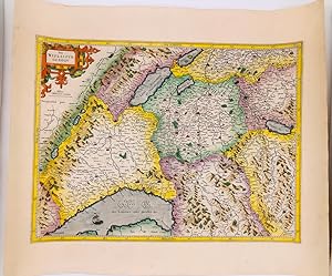
"Das Wiflispurgergou" - Kanton Waadt / Vaud Vierwaldst�ttersee Thuner See Schweiz Suisse Switzerland map Karte carte
Language: German
Published by Amsterdam, Janssonius, 1651
Seller: Antiquariat Steffen V�lkel GmbH, Seubersdorf, Germany
Seller rating 5 out of 5 stars

Map
Blatt-Ma�e: ca. 17,5 x 23 cm -- Original Kupferstich-Karte von Gerard Mercator. R�ckseitig mit deutschem Text. Aus der deutschen Ausgabe des "Atlas Minor" von 1651. - gut erhalten. || Rare original copper engraved map by Gerard Mercator. With German text on verso. From the German edition of the "Atas Minor" from the year 1651. -- in very good condition. || The Flemish engraver and cartographer Jodocus Hondius (15631612), bought Mercator's plates after his death, and published this reduced version of Mercator's folio Atlas sive Cosmographis, and added some 36 of his own maps - a pocketversion - Atlas Minor - which Hondius published together with his partners Cornelius Claesz and Johannes Janssonius. It became a large success, and was translated into several languages and issued in c. 40 editions. // Wir, das Antiquariat Steffen V�lkel, kaufen und verkaufen alte B�cher, Handschriften, Zeichnungen, Autographen, Grafiken und Fotografien. Wir sind stets am Ankauf von kompletten Bibliotheken, Sammlungen und Nachl�ssen interessiert. Sprache: Deutsch Gewicht in Gramm: 10.
-
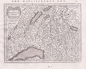
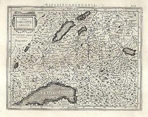
Das Wiflispurgergou
Published by Janssonius, Amsterdam, 1648
Seller: Antikvariat Krenek, Prag, Czech Republic
Association Member: ILAB
Seller rating 5 out of 5 stars
Map
US$ 74.77
US$ 16.84 shipping
Ships from Czech Republic to U.S.A.Quantity: 1 available
Add to basketKein Einband. Condition: Sehr gut. S�dwest Schweiz. "Das Wiflispurgergou". Orig. Kupferstich Karte, J. Janssonius, Amsterdam, 1648-51. Mit ornament. Titelkart., Meillenanzeiger ("Miliar Helveticum Commune") und dt. Titel ("Von Wiflisburger Gow.") oben. 14,5:18,5 cm. Koeman III, map 4920:352.1, ed. 352:32/33 (1648-51 German). - Miniatur-Karte des westlichen Teil der Schweiz. Zeig das Gebiet zwischen Genefersee (Lac L�man), Neuenburgersee (Lac de Neuchatel), Murtensee (Lac de Morat), Bielersee (Lac de Bienne) und Thunersee.
-

"Wiflispurgergovia / Das Wiflispurgergou" - Kanton Waadt / Vaud Vierwaldst�ttersee Thuner See Schweiz Suisse Switzerland map Karte carte
Language: Latin
Published by Amsterdam, Hondius / Janssonius, 1607
Seller: Antiquariat Steffen V�lkel GmbH, Seubersdorf, Germany
Seller rating 5 out of 5 stars
Map
Blatt-Ma�e: ca. 17 x 22 cm -- Seltene original altkolorierte Kupferstich-Karte von Gerard Mercator. R�ckseitig mit lateinischem Text. In seltenem Altkolorit!! -- gut erhalten. || Rare original copper engraved map by Gerard Mercator in original contemporary hand-coloring. With Latin text on verso. -- in good condition. || Dies ist ein Original! - Kein Nachdruck! - Keine Kopie! -- This is an original! - No modern color!! -- No copy! - No reprint! || The Flemish engraver and cartographer Jodocus Hondius (15631612), bought Mercator's plates after his death, and published this reduced version of Mercator's folio Atlas sive Cosmographis, and added some 36 of his own maps - a pocketversion - Atlas Minor - which Hondius published together with his partners Cornelius Claesz and Johannes Janssonius. It became a large success, and was translated into several languages and issued in c. 40 editions. -- This is a very rare example in contemporary handcoloring. // Wir, das Antiquariat Steffen V�lkel, kaufen und verkaufen alte B�cher, Handschriften, Zeichnungen, Autographen, Grafiken und Fotografien. Wir sind stets am Ankauf von kompletten Bibliotheken, Sammlungen und Nachl�ssen interessiert. la Gewicht in Gramm: 10.
-
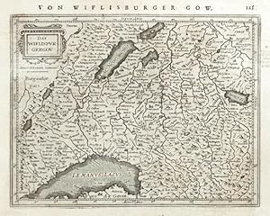
Das Wiflispurgergou
Published by Hondius, Jodocus, Amsterdam, 1607
Seller: Antikvariat Krenek, Prag, Czech Republic
Association Member: ILAB
Seller rating 5 out of 5 stars
US$ 89.72
US$ 16.84 shipping
Ships from Czech Republic to U.S.A.Quantity: 1 available
Add to basket"Das Wiflispurgergou". Orig. copperplate engraving from Mercator's Atlas minor. Published by J. Hondius, 1607. With ornamental title cartouche. 14:18,5 cm (5 1/2 x 7 1/4 inch.). Koeman III, map 4920:351, ed. 351:01 (1607 Atlas Minor). - A miniature map of the Canton of Vaud.
-
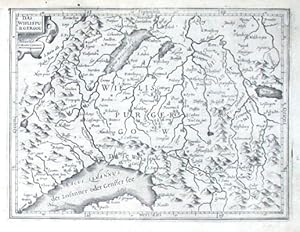
Das Wiflispurgergou.
Published by AmsterdamJansson., 1634
Seller: Robert Frew Ltd. ABA ILAB, London, United Kingdom
Association Member: ABA ILAB PBFA
Seller rating 5 out of 5 stars
Map
US$ 138.25
US$ 13.42 shipping
Ships from United Kingdom to U.S.A.Quantity: 1 available
Add to basket14 x 18.3 cm. Uncoloured. Single page map of eastern Switzerland. Latin text on verso. Some very light show through text, otherwise in very good condition.
-

Das WIFLISPURGERGOU.
Published by Atlas Minor. Jan Jansson. 1651, 2nd German edition., 1651
Seller: Peter Harrington. ABA/ ILAB., London, United Kingdom
Association Member: ABA ILAB PBFA
Seller rating 5 out of 5 stars
US$ 165.90
US$ 29.53 shipping
Ships from United Kingdom to U.S.A.Quantity: 1 available
Add to basketBeautiful map of part of Switzerland to the north of Lake Geneva from Jansson's edition of Mercator's Atlas Minor. Moreland & Bannister, Antique Maps, p.98. Copper engraving. Fine condition. Original colour. Size: 190 x 140 mm. (7� x 5� inches).
-

Kupferstich- Karte, b. Hondius n. Mercator, "Das Wiflispurgergou".
Language: German
Seller: Antiquariat Clemens Paulusch GmbH, Berlin, Germany
Seller rating 5 out of 5 stars
Map
1609, 14,2 x 18,6 Mit kleiner Rollwerkskartusche. Zeigt auch die Kantone Freiburg, Neuenburg und den S�den des Kanton Bern.
-

Das Wiflispurgergou Wiflispurgergow
Published by I.E. Cloppenburgh, Amsterdam, 1632
Seller: Antiquariat Reinhold Berg eK Inh. R.Berg, Regensburg, Germany
Seller rating 5 out of 5 stars
Map Signed
Other. Original antique copper engraving, uncolored as published. A fine copy in a dark impression, full margins as published. This antique map shows Lakes Geneva, Neuchatel, Thun and Biel, along with the cities of Freiburg, Bern and Geneva. Many rivers, towns and smaller villages and mountains are engraved. The title cartouche in the upper left corner. A fine copy in a dark impression, full margins as published.This is the first so-called Cloppenburgh editions which was a competive edition with new engraved maps in a larger format. Most of the maps were engraved by Pieter van den Keere. The Cloppenburgh edition was continued for a couple of years but seems to have been suppressed after 1636. This is another Cloppenburgh edition, now with Latin text. The maps from the Appendix have been incorporated. The title-page is followed by a dedication to Prince Frederik Hendrik, dated 1632 and signed by Johannes Cloppenburgh. (Koeman Atlantes Neerlandici). In excellent condition. 188 by 259mm (7 by 10 inches). 188 by 259mm (7 by 10 inches).
-

Das Wiflispurgergou. - Canton de Fribourg et Vaud.
Published by Vers 1600,, 1600
Seller: Harteveld Rare Books Ltd., Marly, Switzerland
Association Member: ILAB VEBUKU
Seller rating 4 out of 5 stars

14 x 19 cm, petite carte grav�e, 1 feuille (17 x 21.5 cm). Please notify before visiting to see a book. Prices are excl. VAT/TVA (only Switzerland) & postage. Blumer 72.
-

Wiflispurgergow. 399 / Das Wiflispurgergou.
Published by Artist: Sparke Michael ( - 1653 ) London ca : 1620, 1588
Seller: Antique Sommer& Sapunaru KG, M�nchen, Germany
Seller rating 4 out of 5 stars
Technic: Copper print, colorit: original colored, condition: Perfect condition, size (in cm): 14 x 23,5 cm, The map shows the canton of Vaud with Lake Geneva, Lake Neuch�tel, Lake Thun, and Lake Biel, as well as the cities of Fribourg, Bern, Geneva, and a title cartouche. Back side with English text.
-

Das Wiflispurgergou
Published by Duisburg, 1585
Seller: Clive A. Burden Ltd., Chalfont St. Giles, BUCKS, United Kingdom
Seller rating 5 out of 5 stars
Map First Edition
US$ 345.63
US$ 29.73 shipping
Ships from United Kingdom to U.S.A.Quantity: 1 available
Add to basketNo binding. 36 x 47 cms., in fine early wash colour. Good condition. This map of South West Switzerland is in fine early wash colour. Also it is from the first edition of the atlas in 1585 with Latin text to the verso. Van der Krogt, P. (Atlantes) 4920:1A.1.
-
Lake Geneva, Geneva, Freiburg, Thunersee / L�man Das Wiflispurgergou
Published by Hondius, Amsterdam, 1630
Map
Pas de couverture. Condition: Tr�s bon. Gravure sur cuivre publi�e dans "Gerardi Mercatoris Atlas sive Cosmographicae Meditationes" de Fabrica Mundi et Fabricati Figura. 36 x 48 cm. Pli central comme publi�. Couleurs ajout�es ult�rieurement � la main. Tr�s bel �tat. Texte en vieux fran�ais au dos.
-

Das Wiflispurgergou Grenz- und fl�chenkolorierte Original-Kupferstichkarte von Gerhard Mercator, 1620.
Seller: Antiquariat Kurt Lammek, Oldenburg, Germany
Seller rating 4 out of 5 stars
36 x 48 cm. Links oben Titelkartusche, rechts unten Privileg. Im Norden bis Bieler See/ Murtensee/ Lac Neuchatel, im Osten bis Thuner See, im S�dwesten der Genfer See. Etwas gebr�unt, sonst gutes Exemplar.