
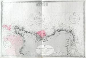
CAPE FLAMANVILLE TO ST. MARCOUF IS. . Detailed sea chart of Cherbourg harbour on the French north coast and its environs, compiled from the latest French Government Charts to 1921. First published by the Admiralty 1888 under the Superintendence of Captain W. J. L. Wharton, and now with small corrections by the
Admiralty Charts.
Published by Admiralty 1953
Map
Condition: Used - Fine
Sold by Garwood & Voigt, Sevenoaks, United Kingdom
AbeBooks Seller since November 25, 2013
Seller rating 4 out of 5 stars
![]()
Used
Condition: Used - Fine
Price:
US$ 135.56
US$ 52.65
shipping from United Kingdom to U.S.A.
Quantity: 1 available
Add to basket