
Belgium.
RAPKIN, J. [TALLIS, John].
Published by London Edinburgh & DublinJ & F Tallis., 1851
Used
From
Robert Frew Ltd. ABA ILAB, London, United Kingdom
Seller rating 4 out of 5 stars
![]()
AbeBooks Seller since March 31, 1998
This specific copy is no longer available. Here are our closest matches for Belgium. by RAPKIN, J. [TALLIS, John]..
About this Item
Description:
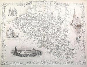
24.5 x 33 cm. Original outline colour. Double page steel engraved map of Belgium. Three vignette illustrations, including one of Antwerp. Decorative scrolling and title cartouche around the edges of the image. Old library stamps to verso. Evenly spotted. For the Great Exhibition in 1851 John Tallis (1817-1876) worked with engraver John Rapkin (1815-1876) to publish the 'Illustrated World Atlas', whose maps were later re-issued by the London Printing and Publishing Company under the Tallis imprint. Their maps are prized for their wonderful steel-engraved vignettes showing the peoples, customs, architecture, landmarks, flora, and fauna of each country. Seller Inventory # 53703
Bibliographic Details
Title: Belgium.
Publisher: London Edinburgh & DublinJ & F Tallis.
Publication Date: 1851
Top Search Results from the AbeBooks Marketplace

Belgium, antique map with vignette views
Published by
John Tallis & Co., London, 1854
Used
Seller: Antipodean Books, Maps & Prints, ABAA, Garrison, NY, U.S.A.
Seller rating 2 out of 5 stars
![]()
Maps. Steel engraved map from the famous Victorian publisher John Tallis, well-known for the attractive vignette views surrounding the maps, which illustrate the peoples & customs of the region. 12 1/2 x 10" plus margins. Attractive decorative border around edge, original hand color. Very good condition. Seller Inventory # 28578
Quantity: 1 available
Belgium, antique map with vignette views
Published by
John Tallis & Co., London, 1854
Used
Seller: Antipodean Books, Maps & Prints, ABAA, Garrison, NY, U.S.A.
Seller rating 2 out of 5 stars
![]()
Maps. Steel engraved map from the famous Victorian publisher John Tallis, well-known for the attractive vignette views surrounding the maps, which illustrate the peoples & customs of the region. 12 1/2 x 10" plus margins. Attractive decorative border around edge, original hand color. Very good condition. Seller Inventory # 19784
Quantity: 1 available

Seller Image
Belgium.
Published by
London Edinburgh & DublinJ. & F. Tallis -1856., 1851
Used
Seller: Robert Frew Ltd. ABA ILAB, London, United Kingdom
Seller rating 4 out of 5 stars
![]()
Original steel-engraved map of Belgium (27 x 36.5 cm). Three vignette illustrations, including one of Antwerp. Decorative scrolling and title cartouche around the edges of the image. Original outline colour. Generally a very good copy. For the Great Exhibition in 1851 John Tallis (1817-1876) worked with engraver John Rapkin (1815-1876) to publish the 'Illustrated World Atlas', whose maps were later re-issued by the London Printing and Publishing Company. Their maps are prized for their wonderful steel-engraved vignettes showing the peoples, customs, architecture, landmarks, flora, and fauna of each country. Seller Inventory # 62900
Quantity: 1 available
Seller Image
Belgium, antique map with vignette views
Published by
John Tallis & Co., London, 1854
Used
Seller: Antipodean Books, Maps & Prints, ABAA, Garrison, NY, U.S.A.
Seller rating 2 out of 5 stars
![]()
Maps. Steel engraved map from the famous Victorian publisher John Tallis, well-known for the attractive vignette views surrounding the maps, which illustrate the peoples & customs of the region. 12 1/2 x 10" plus margins. Attractive decorative border around edge, period outline color, very good condition. Seller Inventory # 14749
Quantity: 1 available
Seller Image
Belgium, antique map with vignette views
Published by
John Tallis & Co., London, 1854
Used
Seller: Antipodean Books, Maps & Prints, ABAA, Garrison, NY, U.S.A.
Seller rating 2 out of 5 stars
![]()
Maps. Steel engraved map from the famous Victorian publisher John Tallis, well-known for the attractive vignette views surrounding the maps, which illustrate the peoples & customs of the region. 12 1/2 x 10" plus margins. Attractive decorative border around edge, with additional hand color of the vignettes and borders. Very good condition. Seller Inventory # 18240
Quantity: 1 available