
Brazil.
RAPKIN, John & [TALLIS, John].
Published by London & New YorkJohn Tallis & Company -1856., 1851
Used
From
Robert Frew Ltd. ABA ILAB, London, United Kingdom
Seller rating 5 out of 5 stars
![]()
Heritage Bookseller
AbeBooks member since 1996
This specific copy is no longer available. Here are our closest matches for Brazil. by RAPKIN, John & [TALLIS, John]..
About this Item
Description:
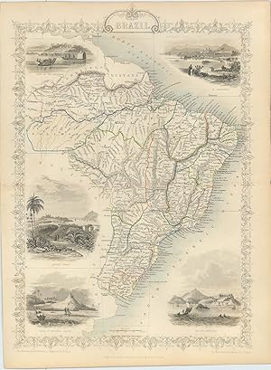
Original steel engraved map of Brazil (27.5 x 36 cm) with original outline colour. With five vignette illustrations, including views of Rio De Janeiro and Montevideo. Decorative scrolling and title cartouche around the edges of the maps. Also includes Uruguay. Original outline colour. Centrefold crease as issued Generally an excellent example. For the Great Exhibition in 1851 John Tallis (1817-1876) worked with engraver John Rapkin (1815-1876) to publish the 'Illustrated World Atlas', whose maps were later re-issued by the London Printing and Publishing Company. Their maps are prized for their steel-engraved vignettes showing the peoples, customs, architecture, landmarks, flora, and fauna of each country. Seller Inventory # 61032
Bibliographic Details
Title: Brazil.
Publisher: London & New YorkJohn Tallis & Company -1856.
Publication Date: 1851
Top Search Results from the AbeBooks Marketplace

Brazil, antique map with vignette views
Published by
John Tallis & Co., London, 1854
Used
Seller: Antipodean Books, Maps & Prints, ABAA, Garrison, NY, U.S.A.
Seller rating 4 out of 5 stars
![]()
Maps. Steel engraved map from the famous Victorian publisher John Tallis, well-known for the attractive vignette views surrounding the maps, which illustrate the peoples & customs of that region. 10 x 13 1/2" plus margins. Attractive decorative border around edge, period outline color, very good condition. Seller Inventory # 28587

Seller Image
Brazil, antique map with vignette views
Published by
John Tallis & Co., London, 1854
Used
Seller: Antipodean Books, Maps & Prints, ABAA, Garrison, NY, U.S.A.
Seller rating 4 out of 5 stars
![]()
Maps. Steel engraved map from the famous Victorian publisher John Tallis, well-known for the attractive vignette views surrounding the maps, which illustrate the peoples & customs of that region. 10 x 13 1/2" plus margins. Attractive decorative border around edge, period outline color, very good condition. Seller Inventory # 13567
Brazil
Used
Seller: Antiqua Print Gallery, London, United Kingdom
Seller rating 5 out of 5 stars
![]()
Condition: Good. BRAZIL. Uruguay as part of Brazil. Rio de Janeiro view TALLIS/RAPKIN 1851 map. Antique engraved map by J Rapkin, published by John Tallis. Original outline hand colour, decorative border, and attractive inset vignette views; Map drawn and engraved by J. Rapkin; vignette illustrations drawn by H Winkles & engraved by W Lacey. Published by John Tallis & Co (1851). 36.5 x 26.5cm, 14.5 x 10.25 inches. Condition: Good. The image shown may have been taken from a different example of this map than that which is offered for sale. The map you will receive is in good condition but there may be minor variations in the condition from that shown in the image. This map was coloured by hand at the time of publication, thus the colouration may vary slightly between different examples of the map; the colouring applied to the map you receive may differ slightly from that shown in the image. There is nothing printed on the reverse side, which is plain. The map shows Uruguay as a state or province of Brazil. An Argentine backed force had laid siege to Montevideo some years earlier, a siege which was relieved by a Brazilian intervention in May 1851, the year of publication of this map. Montevideo rewarded Brazil's support by signing treaties that confirmed Brazil's right to intervene in Uruguay's internal affairs. Vignettes: Boats on the Rio Negro; St. Catharina; Monte Video; Cape St. Antonio - Bahia; Rio De Janeiro. Seller Inventory # P-7-011255
Buy Used
US$ 176.57
US$ 13.19 shipping
Ships from United Kingdom to U.S.A.
Ships from United Kingdom to U.S.A.
Quantity: 2 available
Seller Image
Brazil.
Published by
London & New YorkJohn Tallis & Company -1856., 1851
Used
Seller: Robert Frew Ltd. ABA ILAB, London, United Kingdom
Seller rating 5 out of 5 stars
![]()
Original steel engraved map of Brazil (36 x 27.5 m) With five vignette illustrations, including views of Rio De Janeiro and Montevideo. Decorative scrolling and title cartouche around the edges of the maps. Also includes Uruguay. Original outline colour, with additional later hand colour to vignettes and borde, and to the body of the map. An excellent example. For the Great Exhibition in 1851 John Tallis (1817-1876) worked with engraver John Rapkin (1815-1876) to publish the 'Illustrated World Atlas', whose maps were later re-issued by the London Printing and Publishing Company. Their maps are prized for their steel-engraved vignettes showing the peoples, customs, architecture, landmarks, flora, and fauna of each country. Seller Inventory # 61290
Buy Used
US$ 271.64
US$ 13.19 shipping
Ships from United Kingdom to U.S.A.
Ships from United Kingdom to U.S.A.
Quantity: 1 available
Brazil - with Vignettes and Illustrations of Boats on the Rio Negro / St.Catharina / Monte Video / Cape St. Antonio in Bahia / Rio de Janeiro.
Published by
London & New York, J & F. Tallis., 1851
Used
Seller: Inanna Rare Books Ltd., Skibbereen, CORK, Ireland
Seller rating 5 out of 5 stars
![]()
Original steel engraving / Vintage map. Drawn and engraved by John Rapkin. Partly hand-coloured. Plate Size: 23.9 cm x 34.3 cm. Sheet Size: 27.5 cm x 37.4 cm. Vintage 19th century map in very good condition. John Tallis (7 November 1817 3 June 1876) was an English cartographic publisher. His company, John Tallis and Company, published views, maps and atlases in London from roughly 1838 to 1851. Tallis set up as a publisher with Frederick Tallis in Cripplegate in 1842; the business moved to Smithfield in 1846, and was dissolved in 1849. From 1851 to 1854 Tallis operated as John Tallis and Company. He started The illustrated news of the world and national portrait gallery of eminent personages in 1858, selling it for �1,370 in 1861; it folded in 1863. (Wikipedia) The most important project John Tallis undertook, was the 'Illustrated Atlas' from 1851. The original map we offer here, was part of this exceptional Atlas and all the maps it contained are still today considered as the last reminder of an era of lavish map production. Tallis worked the project together with John Rapkin (1815-1876) and it was Rapkin's style and talent that we have to thank for when we marvel at these maps today. What makes these maps so special is the detail of engraved vignettes that surround the map and often show indigenous scenes, people in their environment and even more so, historical buildings or historical views of towns and cities, architecture and landscape. The project of 'The Illustrated Atlas' was designed to be finished just in time for the anxiously awaited "Great Exhibition of the Works of Industry of All Nations" or The Great Exhibition, sometimes referred to as the Crystal Palace Exhibition in reference to the temporary structure in which it was held, was an international exhibition that took place in Hyde Park, London, from 1 May to 11 October 1851. It was the first in a series of World's Fairs, exhibitions of culture and industry that became popular in the 19th century, and it was a much anticipated event. The Great Exhibition was organized by Henry Cole and Prince Albert, husband of the reigning monarch, Queen Victoria. It was attended by numerous notable figures of the time, including Charles Darwin, Samuel Colt, members of the Orl�anist Royal Family and the writers Charlotte Bront�, Charles Dickens, Lewis Carroll, George Eliot and Alfred Tennyson. Music for the opening was under the direction of Sir George Thomas Smart and the continuous music from the exhibited organs for the Queen's procession was "under the superintendence of William Sterndale Bennett". (Wikipedia) Sprache: english. Seller Inventory # 2004AG
Buy Used
US$ 326.02
US$ 32.23 shipping
Ships from Ireland to U.S.A.
Ships from Ireland to U.S.A.
Quantity: 1 available