About this Item
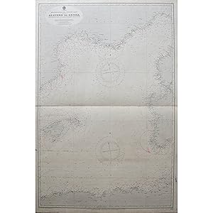
A Collection of 18 of Maritime Charts of the coasts of the Mediterranean and the Black Sea, copper engraved, mostly double-page, many with coastal profiles, vignettes, inset charts, former working maps, cancelled stamp from the Admiralty on some charts, some wear and position markings, London, published by the Admiralty, [1862- 1933] Updated c.1930s These surveys are by some prominent officers and hydrographers. Four of the charts are surveys by Commander F.A. Reyne of the H.M.S. Endeavor. Two are by Cpt T.A.B. Spratt on the H.M.S. Medina, who is best known for his role in the discovery of Troy. Other ships that took part in the surveying include H.M.S. Newport, H.M.S. Stork and H.M.S. Tartarus.Ā Comprising of: Mersa Matruh to Alexandria, 1862; Mersa Matruh to Alexandria, 1862; C.IVI to Algiers, 1867-70; C, Ferret to C. Bougaroni, 1868-74; C, Ferret to C. Bougaroni, 1868-74; Tunis- Fratelli Rocks to Mahedia, 1869; C. Tres Forcast C.IVI, 1870-73; The Port of Alexandria, 1898; Alexandria Harbour, 1898; Ports of Algiers, 1911; Algiers to Genoa, 1927; Port Said, 1929; Port Said, 1929; Alexandria to Port Said, 1929; Alexandria to Port Said, 1929; Dameitta to El Arish, 1930; Mediterranean and Black Seas, 1932, Bahia de Ceuta, 1933. These Admiralty charts or hydrographic charts were produced by the British Admiralty. The Hydrographic Office was established as a sub-department of the Admiralty in 1795 and issued its first officially published Admiralty chart in November 1800.ĀĀ Most Admiralty charts delineate the coastline and high and low water marks, and record the depth of water as established from soundings. They record navigational hazards such as reefs and wrecks, and navigational aids, such as lights, buoys and beacons. Most charts have a compass indicator, often an elaborate compass rose. They also have some indication of scale, either a scale bar or representative fraction, or a border showing degrees of latitude and longitude. One of the characteristics of an Admiralty chart is that it is continually updated and corrected. Obsolete charts were regarded as dangerous and were to be destroyed because they presented a potential navigational hazard. Dates of survey and compilation are minutely recorded, as are those of the corrections continually made to maintain the accuracy and utility of the chart. These corrections were often made by amending the existing copper plates on which the chart was engraved and re-publishing it as a new edition; in other instances, the chart was completely re-drawn. However, in the early years of the Hydrographic Office, published Admiralty charts were drawn on earlier surveys. In extreme cases this means that some charts may be based on surveys made more than a century earlier. For example, Admiralty chart 751, the chart of Maculla Bay which was listed in the first published catalogue of 1825, bears a survey date of 1703. They are also numbered in manuscript to record when they were updated. Some Admiralty charts contain little information on areas inland of the foreshore other than that required to assist in making a landfall. Others include extensive representations of land features and may also have coastal elevations and topographic views as insets. Nineteenth-century charts in particular may include ground plans of sites of archaeological interest, or details of coastal forts and other defences, as well as pictures of natural features. Some insets contain detailed charts of harbours. Admiralty charts record names given to coastal features and include many names no longer in use today. In many instances they also provide the best and most easily accessible maps of small oceanic islands. Some charts record surveys of navigable rivers. This collection ofĀ charts records the date of the survey, the captain, officer and in many cases the ship or ships that took part. Seller Inventory # 6155
Contact seller
Report this item

