
Jamaica.
RAPKIN, J. & [TALLIS, John].
Published by London & New YorkJohn Tallis & Company -1856., 1851
Used
From
Robert Frew Ltd. ABA ILAB, London, United Kingdom
Seller rating 5 out of 5 stars
![]()
Heritage Bookseller
AbeBooks member since 1996
This specific copy is no longer available. Here are our closest matches for Jamaica. by RAPKIN, J. & [TALLIS, John]..
About this Item
Description:
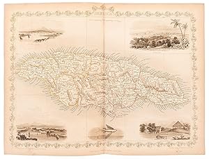
Original steel engraved map. Five vignette illustrations including one of Kingston and a seal. Decorative scrolling and title cartouche around the edges of the image. (Map 22 x 29.5 cm, overall sheet 27.5 x 36 cm). Original outline colour. Centrefold crease as issued. In very good condition. For the Great Exhibition in 1851 John Tallis (1817-1876) worked with engraver John Rapkin (1815-1876) to publish the 'Illustrated World Atlas', whose maps were later re-issued by the London Printing and Publishing Company. Their maps are prized for their wonderful steel-engraved vignettes showing the peoples, customs, architecture, landmarks, flora, and fauna of each country. Seller Inventory # 54436
Bibliographic Details
Title: Jamaica.
Publisher: London & New YorkJohn Tallis & Company -1856.
Publication Date: 1851
Top Search Results from the AbeBooks Marketplace

Seller Image
Jamaica.
Published by
London & New YorkJohn Tallis & Company -1857., 1851
Used
Seller: Robert Frew Ltd. ABA ILAB, London, United Kingdom
Seller rating 5 out of 5 stars
![]()
Original steel engraved map of the island of Jamaica (map 31.5 x 22 cm, overall sheet 36 x 28 cm). Map with decorative vignette scenes of Port Antonio, a Sugar Mill, Kingston, and Port Royal Harbour. Decorative ornamentation and scrolling around the borders of the map. Original outline colour. Centrefold crease as issued. Nice clean example. Seller Inventory # 65002
Buy Used
US$ 174.10
US$ 13.52 shipping
Ships from United Kingdom to U.S.A.
Ships from United Kingdom to U.S.A.
Quantity: 1 available