![Part of South Australia.: RAPKIN, J. & [TALLIS, John].](https://pictures.abebooks.com/inventory/30421248381.jpg)
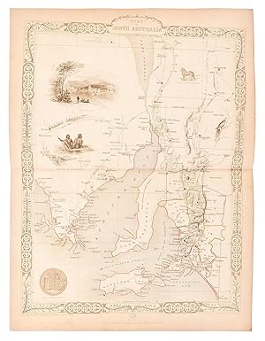
Part of South Australia.
RAPKIN, J. & [TALLIS, John].
Published by London & New YorkJohn Tallis & Company -1856., 1851
Used
From
Robert Frew Ltd. ABA ILAB, London, United Kingdom
Seller rating 4 out of 5 stars
![]()
AbeBooks Seller since March 31, 1998
About this Item
Description:
Original steel engraved map concentrating on the area around Spencer Gulf, including Adelaide. Five vignette illustrations including those of Adelaide and of Aborigines. Mining districts shown. Decorative scrolling and title cartouche to the edges of the image. (Map 22 x 29.5 cm, overall sheet 27.5 x 36 cm). Original outline colour. Centrefold crease as issued. In very good conditoin. For the Great Exhibition in 1851 John Tallis (1817-1876) worked with engraver John Rapkin (1815-1876) to publish the 'Illustrated World Atlas', whose maps were later re-issued by the London Printing and Publishing Company. Their maps are prized for their steel-engraved vignettes showing the peoples, customs, architecture, landmarks, flora, and fauna of each country. Seller Inventory # 54497
Bibliographic Details
Title: Part of South Australia.
Publisher: London & New YorkJohn Tallis & Company -1856.
Publication Date: 1851
Top Search Results from the AbeBooks Marketplace
Part of South Australia [Antique Map]
Published by
John Tallis, London, 1851
Used
Seller: Books & Bidders, Cleveland, OH, U.S.A.
Seller rating 5 out of 5 stars
![]()
Condition: Very Good. [Australia Map]. Original steel engraved map with decorative boarder and vignettes. Map size with central vertical fold is approx. 11 x 14 inches. Original antique map of "part of South Australia" by John Tallis & Company, circa 1851. Vignettes of Adelaide, Natives of Catmaran, Dingo or Australian Dog, Seal of South Australia, and Nymphicua bird. Map drawn and engraved by John Rapkin, with illustrations by H. Warren and engraved by J. Rogers. Contemporary pen outlining in color and pale blue coastline wash. By 1865 Tallis was among the last of the publishers of beautifully decorated hand engraved maps. Shows some expected page toning and light wear at corners. Map. Seller Inventory # 005943
Quantity: 1 available

Seller Image
Part of South Australia, antique map with vignette views
Published by
John Tallis & Co., London, 1851
Used
Seller: Antipodean Books, Maps & Prints, ABAA, Garrison, NY, U.S.A.
Seller rating 2 out of 5 stars
![]()
Maps. Steel engraved map from the famous Victorian publisher John Tallis, well-known for the attractive vignette views surrounding the maps, which illustrate the peoples & customs of the region. With a vignette views of Adelaide, Natives, Seal, Dingo and Nymphicus, with the mining districts marked in red. Tooley 1231. 10 x 13 1/2" plus margins. Attractive decorative border around edge, period outline color, very good condition. Seller Inventory # 16440
Quantity: 1 available
Seller Image
Part of South Australia.
Published by
London & New YorkJohn Tallis & Company -1856., 1851
Used
Seller: Robert Frew Ltd. ABA ILAB, London, United Kingdom
Seller rating 4 out of 5 stars
![]()
Original steel engraved map concentrating on the area around Spencer Gulf, including Adelaide. Five vignette illustrations including those of Adelaide and of Aborigines. Mining districts shown. Decorative scrolling and title cartouche to the edges of the image. (Map 22 x 29.5 cm, overall sheet 27.5 x 36 cm). Original outline colour. Centrefold crease as issued. One small instance of light browning to centre fold, generally a very good copy. For the Great Exhibition in 1851 John Tallis (1817-1876) worked with engraver John Rapkin (1815-1876) to publish the 'Illustrated World Atlas', whose maps were later re-issued by the London Printing and Publishing Company. Their maps are prized for their steel-engraved vignettes showing the peoples, customs, architecture, landmarks, flora, and fauna of each country. Seller Inventory # 61477
Quantity: 1 available