Henricus Hondius (148 results)

Published by Contentum Ltd., Larnaca, Cyprus
- Art Print
Seller: Contentum, Nicosia, CyprusContentum
Contact seller4-star sellerCondition: New
US$ 21.50
US$ 16.82 shippingShips from Cyprus to U.S.A.Quantity: Over 20 available
Loose Leaf. Condition: New. Reproduction. Original title: Map of the Netherlands, 1631 German: Karte der Niederlande, 1631 French: Carte des Pays-Bas, 1631 Spanish: Mapa de los Países Bajos, 1631 High-quality fine-art reproduction based on an original work from the Rijksmuseum. Creation period: 17th century (1631). Professionall…y printed on premium fine-art paper (Photo Matt Fibre) in size A5. The motif is printed with a white border (museum-style presentation). No.
Language: French
Published by ca. 1630. 1630
- Art Print
Seller: Antiquariat Steffen Völkel GmbH, Seubersdorf, GermanyAntiquariat Steffen Völkel GmbH
Contact seller5-star sellerCondition: Used
US$ 17.92
US$ 34.81 shippingShips from Germany to U.S.A.Quantity: 1 available
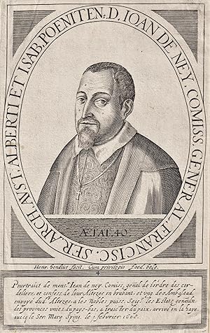
Original Kupferstich-Portrait von ca. 1630 - Bild-Maße: ca. 20 x 12 cm - knapp beschnitten und aufmontiert, sonst gut erhalten. | original engraved portrait from from c. 1630 - narrowly cut and mounted on paper, otherwise in very good condition. // Wir, das Antiquariat Steffen Völkel, kaufen und verkaufen alte Bücher, Handschrif…ten, Zeichnungen, Autographen, Grafiken und Fotografien. Wir sind stets am Ankauf von kompletten Bibliotheken, Sammlungen und Nachlässen interessiert. Sprache: Französisch Gewicht in Gramm: 10.

Language: English
Published by Jan Jansson, Amsterdam. 1640
Seller: Hornseys, Ripon, , United KingdomHornseys
Contact seller5-star sellerCondition: Used - Good
US$ 277.07
US$ 33.62 shippingShips from United Kingdom to U.S.A.Quantity: 1 available
No Binding. Condition: Good. PERU - ORIGINAL COPPER ENGRAVING. Price: £200.00. Publisher: Jan Jansson, Amsterdam. Publication date: circa 1635-40. Format: Original copper engraving. Condition: In good condition, unframed. Sheet Size: 49.4cm x 57.4cm. Condition: Latin text verso. Age-toning, surface wear, nicks to the outer margi…ns and very short closed tears, not affecting the plate surface, and creasing. Early hand-colouring. In good to very good condition overall. Early Map of Peru from the Mercator-Hondius Atlas: A Short Description: This fine, early map of Peru, published by the esteemed cartographer Jan Jansson in Amsterdam during the Dutch Golden Age, offers a striking depiction of the Viceroyalty of Peru - one of the most lucrative colonies in the Spanish Empire at the time. This map, part of the renowned Mercator-Hondius atlas, provides a fascinating glimpse into the region's geography with an eastern orientation.
 More images
Language: French
Published by Frederick De Wit, Amsterdam 1697
- Softcover
Seller: Hic Sunt Dracones, Saint Hilaire Saint Mesmin, , FranceHic Sunt Dracones
Contact seller5-star sellerCondition: Used - Very good
US$ 956.12
US$ 46.41 shippingShips from France to U.S.A.Quantity: 1 available
Couverture souple. Condition: Assez bon. "Grondige Onderrichtinge in de Optica, ofte perspective konste" Henricus Hondius Amsterdam, Frederick De Wit, 1697 20x30 cm Demie percaline ultérieure (fin XIXème), état correct. Plats frottés. 10 feuillets de texte (sur 12 : manquent les feuillets C1 et C2). 34 planches gravées (sur 36 :… manquent les planches 30 et 31). Planche 34 en doublon. Forte mouillure sur les feuillets de texte, épargnant les planches. La plupart des feuillets sont volants, détachés. Traces de restaurations anciennes. Rare exemplaire, "dans son jus", de ce traité de perspective, par Henricus Hondius, un éditeur et graveur de l'âge d'or hollandais.
 More images
Language: French
Published by Chez Jean Jeansson 1620
- Hardcover
- First Edition
Seller: Librairie du Cardinal, GRADIGNAN, , FranceLibrairie du Cardinal
Contact seller5-star sellerCondition: Used - Near fine
US$ 3,406.18
US$ 29.01 shippingShips from France to U.S.A.Quantity: 1 available
rigide. Condition: Bon. Avec encores quelques belles Ordonnances d'Architecture, mises en perspective, Inventées par Jean Vredeman, Frison, & son fils, & taillées par le dit H. Hondius, de nouveau reveües & corrigées, fort serviables & utiles pour la fortification & autres usages, 1 vol. in-folio oblong reliure de l'époque plein… vélin, Chez Jean Jeansson, A Amstredam [ Amsterdam ], 1620, 40 ff. non ch. (dont 1 f. de titre, 8 ff. de texte - dont un imprimé recto-verso -, dernier feuillet blanc et 30 planches gravées sur cuivre par Hondius) Rare exemplaire de la seconde édition parue sous ce nouveau titre, trois ans après l'édition publiée en 1617 et dix ans après l'édition originale de la traduction française parue sous le titre de "La Haulte & fameuse science consistante, en cincq manières d'édifices ou fabriques [ . ]". Notre exemplaire de cet important ouvrage d'architecture est parfaitement complet, avec ses 30 planches gravées par Hondius. Vredeman (1527-1607) développa l'emploi de la perspective linéaire dans le monde flamand. Bon état (reliure frottée avec ancienne tache d'encre au premier plat, traces d'usages sur les ff., petit travail de vers en marge intérieure sur qq. ff. n'affectant pas le texte, des mouill., petit accroc sans mq. à un f. de texte, bon état par ailleurs, ex-libris ms. anciens Jean Dormoy et Mouneyra). Langue: Français.

Language: English
Published by Amsterdam: Hondius, c. 1628., Amsterdam: 1628
- Map
Seller: BOSPHORUS BOOKS, Istanbul, , TurkeyBOSPHORUS BOOKS
Contact seller4-star sellerCondition: Used - Fine
US$ 1,135.39
US$ 40.61 shippingShips from Turkey to U.S.A.Quantity: 1 available
No Binding. Condition: Fine. MERCATOR, GERARD - HENRICUS HONDIUS [MAP]. Natoliae sive Asia Minor. Amsterdam: Hondius, c. 1628. 35x48 cm. Hand coloured copper engraved antique map of Antatolia. Fine ISBN: CATALOG: Maps & Engravings KEYWORDS: Map Geography Anatolia Collection Atlas - Mapbook Cartography Istanbul - Constantinople A…egean Mediterranean Black Sea.
 More images
Published by Editat per l'Institut Cartogràfic de Catalunya, Barcelona 2006
- Hardcover
Seller: Libreria Rosela, BARCELONA, B, SpainLibreria Rosela
Contact seller5-star sellerCondition: Used - Near fine
US$ 197.20
US$ 52.80 shippingShips from Spain to U.S.A.Quantity: 1 available
Tapa Dura. Condition: MUY BUEN ESTADO. Cartoné folrat en tela de vellut negre editorial, exemplar i caixa contenidora rigida, amb lletres i motiu en plata a coberta i llom amb cinta en seda negra interior, fermall a manera de sivella per a la subjecció de la carpeta que conté el mapa a l'esquerra i llibret de text descriptiu a l…a dreta. Bell document d'edició limitada a 200 exemplars. Complet i en Excel lent estat Size: 36,5x25,5cm.
 More images
Published by c. 1631, Amsterdam 1631
- Softcover
- Map
Seller: Bolivar Old Prints Anticuario, Barcelona, B, SpainBolivar Old Prints Anticuario
Contact seller5-star sellerCondition: Used - Near fine
US$ 370.50
US$ 29.01 shippingShips from Spain to U.S.A.Quantity: 1 available
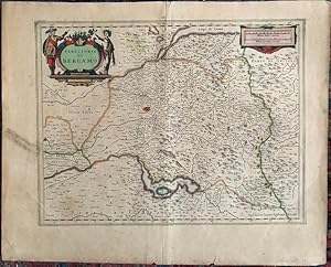
Condition: Muy Bueno. 450 x 550. Mapa antiguo original del Reino de Aragón, grabado por Henricus Hondius y editado en Ámsterdam hacia 1631. Su título completo es "Novissima Arragoniae Regni Tabula" ("Mapa más reciente del Reino de Aragón"). El mapa representa el territorio histórico del Reino de Aragón, situado en el noreste de…la península ibérica, limitando al norte con los Pirineos, al este con Cataluña y el Mediterráneo, al sur con Valencia y al oeste con Castilla y Navarra. Se encuentra orientado al occidente. Se puede apreciar el río Ebro, desde Tortosa hasta Zaragoza y Calahorra.Las principales ciudades, como Teruel, Calatayud, Monzón, Barbastro y Alcañiz, están señaladas por varios campanillos y símbolos, en función de su importancia. En la parte inferior izquierda, el autor dedica el mapa a los "ilustrísimos señores diputados del Reino de Aragón", a quienes nombra.Durante el siglo XVII, el Reino de Aragón formaba parte de la Corona de Aragón, que junto con Castilla conformaba la monarquía hispánica. Henricus Hondius (1597-1651) fue un cartógrafo y editor holandés establecido en Ámsterdam, hijo de Jodocus Hondius, quien continuó el trabajo editorial de su padre publicando atlas y mapas de gran difusión en Europa. Descripción del Aragón y de Cataluña al verso, en francés. Grabado en cobre, en negro.--------------------Original antique map of the Kingdom of Aragon, engraved by Henricus Hondius and published in Amsterdam around 1631. Its full title is "Novissima Arragoniae Regni Tabula" ("Most Recent Map of the Kingdom of Aragon"). The map represents the historic territory of the Kingdom of Aragon, located in the northeast of the Iberian Peninsula, bordered to the north by the Pyrenees, to the east by Catalonia and the Mediterranean, to the south by Valencia, and to the west by Castile and Navarre. It is oriented to the west. The Ebro River can be seen, from Tortosa to Zaragoza and Calahorra.The main cities, such as Teruel, Calatayud, Monzón, Barbastro, and Alcañiz, are represented by various bells and symbols, according to their importance. In the lower left part, the author dedicates the map to the "most illustrious gentlemen deputies of the Kingdom of Aragon", whom he names.During the 17th century, the Kingdom of Aragon was part of the Crown of Aragon, which together with Castile formed the Hispanic monarchy. Henricus Hondius (1597-1651) was a Dutch cartographer and publisher established in Amsterdam, son of Jodocus Hondius, who continued his father's publishing work by producing atlases and maps widely distributed in Europe. Description of Aragon and Catalonia on the verso, in French. Copper engraving, in black. Ligero desgaste en el antiguo doblez, buen estado general.
 More images
Published by Ámsterdam 1636
- Softcover
- Map
Seller: Bolivar Old Prints Anticuario, Barcelona, B, SpainBolivar Old Prints Anticuario
Contact seller5-star sellerCondition: Used - Very good
US$ 382.45
US$ 29.01 shippingShips from Spain to U.S.A.Quantity: 1 available
No Binding. Condition: Bueno. Muy decorativo mapa de Castilla que comprende Extremadura, Castilla la Nueva, Ávila, Salamanca y parte de Burgos, Logroño, Palencia, Aragón, Valencia, Jaén, Madrid, Córdoba, Sevilla, Granada, Murcia, entre otros. Fue publicado en Ámsterdam en la obra Nouveau Theatre du Monde ou Nouvel Atlas comprena…nt Les Tables et Descriptions de toutes les Regions de la Terre. Contiene muchos elementos interesantes como la cartela del título ornamentada y coronada por un orbe, los escudos de Castilla y del antiguo reino de Toledo, una leyenda con ubicación de episcopados y universidades y una pequeña cartela decorada con la escala. Abundante toponimia en castellano y latín, y orografía de perfil. Henricus Hondius (1597-1651) fue un cartógrafo y grabador holandés, miembro de una prominente familia de cartógrafos. Mientras trabajó con su padre, el famoso Jodocus Hondius, jugó un papel fundamental en la reedición del atlas de Mercator, publicado por primera vez en 1595. A la muerte de su padre en 1612, Henricus y su hermano, Jodocus el Joven, continuaron con el negocio familiar. Estableció su primera tienda en 1621 y más adelante se asoció con su cuñado, Jan Janssonius, otro afamado cartógrafo, con quien continuó expandiendo y publicando el atlas de Mercator, mismo que terminó conociéndose como el atlas Mercator-Hondius-Janssonius. Murió en 1651. 41 x 50 cm. 5413 Map Carte Utriusque Castiliae Nova Descriptio Ámsterdam Hondius, Henricus 1636 Good 320 FRA. Good.

Published by c. 1630, Amsterdam 1630
- Softcover
- Map
Seller: Bolivar Old Prints Anticuario, Barcelona, B, SpainBolivar Old Prints Anticuario
Contact seller5-star sellerCondition: Used - Very good
US$ 454.16
US$ 29.01 shippingShips from Spain to U.S.A.Quantity: 1 available
Condition: Bueno. 37,5 x 48cm. Precioso mapa detalladamente coloreado de la zona litoral central de Chile. Este mapa fue publicado por Hendrik Hondius en c.1630. En el mapa se nos muestra una parte del litoral de Chile que va de sur (Parte derecha de la hoja) hasta el norte (Parte izquierda de la hoja) donde podemos encontrar di…ferentes localidades como Castro, en la isla de Grande de Chiloé, Valdivia, Arauco, Concepción, "Mapocho" (Santiago de Chile). En la parte inferior en el mar podemos encontrar dos bergantines que ondean la bandera holandesa además de criaturas fantásticas que acompañan la obra. En cuanto a la representación del relieve, encontramos la sierra de Los Andes altamente ilustrada, así como diferentes ríos. Cabe destacar la representación de dos volcanes al frente del municipio de Villa Rica. En su parte superior encontramos a los extremos el título y la escala que van acompañadas de una preciosa cartela coloreada. En la parte posterior de la hoja encontramos un texto en francés que nos habla de la zona de Chile, así como de sus provincias y ciudades más importantes. Dimensiones del mapa: 37,5 x 48cmCondición: buena, con una marca de plegado.ChiliPalabras clave: "Chile", "Hendrik Hondius", "Santiago", "Concepción", "Mapocho". Español.
 More images
Published by Ámsterdam 1660
- Softcover
- Map
Seller: Bolivar Old Prints Anticuario, Barcelona, B, SpainBolivar Old Prints Anticuario
Contact seller5-star sellerCondition: Used - Very good
US$ 693.19
US$ 29.01 shippingShips from Spain to U.S.A.Quantity: 1 available
No Binding. Condition: Bueno. Mapa que contiene la provincia de Zaragoza y parte de las de Huesca y Teruel. Incluye dos cartelas muy decorativas, una con el título y la escala rodeada por puti y un escudo en blanco rematado por una corona; la otra con una leyenda en latín y también rodeada por elementos ornamentales y puti. Dos…escudos de Navarra y Castilla se localizan en las esquinas superiores de la impresión. Las ciudades más importantes están identificadas pictográficamente como una agrupación de edificios, la orografía está representada por montañas de perfil y sombreadas y las divisiones entre los obispados están remarcadas en color. Fue realizado por Henricus Hondius (1597-1651), cartógrafo y grabador holandés, miembro de una prominente familia de cartógrafos. Mientras trabajó con su padre, el famoso Jodocus Hondius, jugó un papel fundamental en la reedición del atlas de Mercator, publicado por primera vez en 1595. A la muerte de su padre en 1612, Henricus y su hermano, Jodocus el Joven, continuaron con el negocio familiar. Estableció su primera tienda en 1621 y más adelante se asoció con su cuñado, Jan Janssonius, otro afamado cartógrafo, con quien continuó expandiendo y publicando el atlas de Mercator, mismo que terminó conociéndose como el atlas Mercator-Hondius-Janssonius. Murió en 1651. 41 x 52.5 cm. FRA. Good.

Published by Amsterdam, Weduwe Josua Ottens, n.d. [c. 1750]. 1750
- Hardcover
Seller: Charbo's Antiquariaat, Amsterdam, , NetherlandsCharbo's Antiquariaat
Contact seller5-star sellerCondition: Used - Very good
US$ 1,314.67
US$ 43.51 shippingShips from Netherlands to U.S.A.Quantity: 1 available
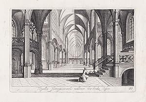
Condition: VG. Small folio. Engraved title, title, 24 pages text + 36 engr. plates (incl. 2 fold.) containing 43 figures showing perspectival designs and ills. (e.g. staircase, houses, arches, etc.). Hardcover. Contemp. vellum spine, marbled boards. (Covers sl. dam,/rubbed, fine interior condition). * Bierens de Haan 2116. First… publised in 1622. Several (mostly undated) reprints were publised from 1647 to c. 1770.
Published by Sterling Publishing House, Co., Inc, New York 1960
- First Edition
Seller: Between the Covers-Rare Books, Inc. ABAA, Gloucester City, NJ, U.S.A.Between the Covers-Rare Books, Inc. ABAA
Contact seller5-star sellerCondition: Used - Very good
US$ 100.00
US$ 5.50 shippingShips within U.S.A.Quantity: 1 available
Unbound. Condition: Very Good. Portfolio. Color facsimiles of 36 historical maps. Each map measures approximately 12" x 9", printed on 17" x 11½" paper with descriptive text in the left margin. Housed with a title page sheet and unprinted top sheet in a four-fold chemise. Unprinted topsheet sunned at the edges, first two leaves…with some very light toning and a couple of tiny corner creases; the maps are otherwise bright and fine. The chemise is good only with toning, wear, and soil, and a 1" creased tear on the cover panel. A nice production, and the chemise has done its job, keeping the maps bright and fresh.
Language: Latin
Published by Amsterdam ca. 1640. 1640
- Art Print
Seller: Antiquariat Steffen Völkel GmbH, Seubersdorf, GermanyAntiquariat Steffen Völkel GmbH
Contact seller5-star sellerCondition: Used
US$ 59.75
US$ 34.81 shippingShips from Germany to U.S.A.Quantity: 1 available
Original Kupferstich von ca. 1640.-- Blatt-Maße: ca. 29,5 x 39 cm. -- mit alt hinterlegtem Randeinriss, sonst gut erhalten. || Original copper engraving from c. 1640. -- with a deposited marginal tear, otherwise in good condition. // Wir, das Antiquariat Steffen Völkel, kaufen und verkaufen alte Bücher, Handschriften, Zeichnunge…n, Autographen, Grafiken und Fotografien. Wir sind stets am Ankauf von kompletten Bibliotheken, Sammlungen und Nachlässen interessiert. la Gewicht in Gramm: 15.
Published by Johannes Janssonius, Amsterdam 1607
- Map
Seller: Antiquariat Hieronymus, München, , GermanyAntiquariat Hieronymus
Contact seller5-star sellerCondition: Used - Very good
US$ 81.27
US$ 44.09 shippingShips from Germany to U.S.A.Quantity: 1 available
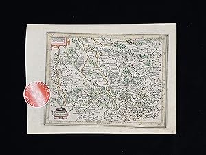
Condition: Gut. Gut. Kupferstich, altkoloriert. Blattgröße: 16,7 x 23,6 cm, Druckspiegel: 14,7 x 18,8 cm. . Kräftiger und guter Druck auf leicht gebräuntem Papier, insgesamt gut erhalten. Schöne kleine Landkarte des südlichen Lothringen ("Lotharingia meridiona.[lis]"), zwischen Maas und Vogesen mit dem oberen Lauf der Mosel bis…Nancy, aus: "Atlas Minor", Amsterdam 1607. Landkarte, map, carte géographique, carta geografica, France, Frankreich, Francia, Lothringen, Lorraine, Lorena. 400 Gramm.
Bresse.
Hondius, Jodocus (1563-1612); Hondius, Henricus (1597-1651); Janssonius, Johannes (1588-1664)
Published by Mercator, um 1610.
Seller: Antiquariat Cellensia, Celle, , GermanyAntiquariat Cellensia
Contact seller4-star sellerCondition: Used
US$ 107.56
US$ 69.62 shippingShips from Germany to U.S.A.Quantity: 1 available
Gefaltete alt-kolorierte Kupferstich-Karte. Blattmaß: 61 x 47 cm. Mit kleinem Riss im unterem Rand. Alterbedingt leicht gebräunt. Fotos gerne auf Anfrage.
 More images
Utriusque Alsatiae superioris ac inferioris nova tabula (Frankreich, Elsass, Oberelsaß, Unterelsaß).
Published by Johannes Janssonius, Amsterdam 1648
- Map
Seller: Antiquariat Hieronymus, München, , GermanyAntiquariat Hieronymus
Contact seller5-star sellerCondition: Used - Very good
US$ 191.22
US$ 44.09 shippingShips from Germany to U.S.A.Quantity: 1 available
Condition: Gut. Gut. Kupferstich (in Passepartout montiert). Blattgröße (Passepartout): 52,5 x 63,5 cm, Ausschnittsgröße: 49 x 54,5 cm . Schöner und gleichmäßiger Druck auf etwas gebräuntem Papier, dieses in wenig gebräuntem Passepartout montiert, rechte obere Ecke restauratorisch ergänzt, insgesamt gut erhalten. Schöne und selt…ene Karte des Elsaß (oberes und unteres Elsass) nach Westen hin orientiert, u.a. mit den Städten Strassburg (Strasbourg) und Breisach (Brisach). Mit Titel und Legendenkartusche sowie zwei Wappen der Landgrafen des oberen und unteren Elsass. Landkarte, map, carte géographique, carta geografica, Frankreich, France, Elsass, Elsaß, Oberelsass, Unterelsass, Haute Alsace, Bas-Rhin, Grand Est. 1600 Gramm.
 More images
Published by Selbstverlag, Amsterdam 1549
- Map
Seller: Antiquariat Hieronymus, München, , GermanyAntiquariat Hieronymus
Contact seller5-star sellerCondition: Used - Very good
US$ 191.22
US$ 44.09 shippingShips from Germany to U.S.A.Quantity: 1 available
Condition: Gut. Gut. Kupferstich, altkoloriert. Blattgröße: 45 x 57 cm, Druckspiegel: 36 x 43 cm. . Kräftiger und klarer Druck auf wenig, im oberen Falz stärker gebräuntem Papier, oben links Fältelung, insgesamt gut erhalten. Schöne große Landkarte des oberen Elsass um Strassburg nach Westen hin orientiert. Mit hübscher Rollwerk…kartusche im Stil der Renaissance. Landkarte, map, carte géographique, carta geografica, France, Frankreich, Francia, Alsace, Alsazia, Alsace, Black Forrest, Foresta Negra, Foret-Noire, Strasbourg, unteres. 1800 Gramm.
 More images
Published by [Amsterdam: Jansson, c.1640]. 1640
Seller: William Matthews/The Haunted Bookshop, Sidney, BC, CanadaWilliam Matthews/The Haunted Bookshop
Contact seller5-star sellerCondition: Used
US$ 221.28
US$ 18.00 shippingShips from Canada to U.S.A.Quantity: 1 available
Copper-engraved map on laid paper, hand-coloured cartouches in lower left corner. Hand-colouring to entire map. Text on the verso in French, heading titled: Le Territoire de BASLE. Hand-coloured initial on verso. Signature mark on verso is IIi. Plate size is 49cm x 38cm, on a sheet measuring 55cm x 48.5cm. Old yellowed tape repa…ir on verso at fold and edges, some splitting at fold, pin holes to margins, tears in lower margin, very good condition. Probably from the French edition of Jansson's "Nouveau Theatre du Monde ou Nouvel Atlas" [c.1640]. Numbered in pencil at upper right with the numeral "67". From WorldCat's description: "The first French editions of the Atlas Novus appeared in three volumes in 1639, a year after the inaugural Latin version. The promptness with which the translation was readied meant that these were largely identical to the Latin original in material and structure, although several revisions were made to the order of contents to better tailor Jansson's offering to the Francophone market: thus, the French part of the Atlas was given new precedence over the Dutch one, and the Spanish and Portuguese chapters were detached from the French section in order to give the latter a stronger thematic coherence than it had previously had. Despite these similarities, the publication of the French editions was quite different from the Latin. After issuing the latter together, by 1639 Jansson and Hondius had resolved to print their own copies of the French title under their own imprints, and this division of resources and duplication of editions has resulted in a distinct, more complex publishing history. Indeed, variations in the stock of plates available to the former partners resulted in two quite separate classes of Atlas, with as many as twenty-five different maps between them, Jansson's typically the more up to date. Matters are further complicated by both Jansson and Hondius' habit of regularly updating their imprints for several years from 1639 onwards, resulting in confusing arrays of dates across the volumes of a single set.".
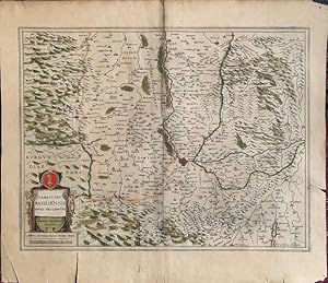
Published by Amsterdam, Hondius, 1627. 1627
Seller: Antiquariat MEINDL & SULZMANN OG, Wien - Vienna, , AustriaAntiquariat MEINDL & SULZMANN OG
Contact seller5-star sellerCondition: Used
US$ 215.13
US$ 40.61 shippingShips from Austria to U.S.A.Quantity: 1 available
Blattgröße ca. 39,5 x 49 cm. Bildausschnitt ca. 33 x 42,5 cm (Mittelfalz geglättet. Papier gebräunt und etw. braunfleckig). Henricus Hondius II., auch Hendrik Hondius der Jüngere (1597- 1651) war der Sohn des berühmten Kartographen Jodocus Hondius, der in Amsterdam ein kartographisches Unternehmen gegründet hatte. Nachdem Hendri…k zunächst im elterlichen Betrieb mitgearbeitet hatte, gründete er 1621 in seiner Heimatstadt einen eigenen Verlag. 1633 ging Henricus eine Partnerschaft mit dem Kartographen und seinem Schwager Johannes Janssonius ein, und gemeinsam führten sie das Geschäft weiter.- Rückseite mit lateinischem Text: "Moravia Marchionatus Marhern Germanis . Nomen habet à fluvio Morava.".- Im unteren Teil der Karte (Süden) auch Teile des Weinviertels mit einigen Ortschaften eingezeichnet, wie z.B.: Mailberg, Pulkau, Schrattenthal, Retz, Staatz, Mistelbach, Herrenbaumgarten, Falkenstein, Wildendürnbach, Poysdorf etc.
 More images
Published by Johannes Janssonius, Amsterdam 1648
- Map
Seller: Antiquariat Hieronymus, München, , GermanyAntiquariat Hieronymus
Contact seller5-star sellerCondition: Used - Very good
US$ 215.13
US$ 44.09 shippingShips from Germany to U.S.A.Quantity: 1 available
Condition: Gut. Gut. Kupferstich auf Passepartout montiert, altkoloriert. Blattgröße: 18,5 x 23 cm, Druckspiegel: 20,5 x 16 cm. . Kräftiger und klarer Druck auf leicht gebräuntem Papier, auf Passepartout montiert, insgesamt gut erhalten. Sehr schöne und seltene Landkarte von Navarra, aus der deutschen Ausgabe: "Atlas Minor. Das…ist: Eine kurze jedoch gründliche Beschreibung der ganzen Welt, in zwey Theile abgetheilt", Bd. 1, Amsterdam 1648. Landkarte, map, carte géographique, carta geografica, Spanien, Nordspanien, Spain, Espagnia, Espana, Spagna, Espagne, Navarre, Navarra. 1200 Gramm.
 More images
Published by Amsterdam: Jansson, [c.1640]. 1640
Seller: William Matthews/The Haunted Bookshop, Sidney, BC, CanadaWilliam Matthews/The Haunted Bookshop
Contact seller5-star sellerCondition: Used
US$ 239.72
US$ 18.00 shippingShips from Canada to U.S.A.Quantity: 1 available
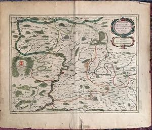
Copper-engraved map on laid paper, hand-coloured cartouche in upper right. Hand-colouring to entire map. Imprint at lower margin: "Joannes Janssonius execudit". Text on the verso in French, heading titled Le Comte De WERTHAIM. Hand-coloured initial on verso. Signature mark on verso is YY. Plate size is 50.5cm x 39cm, on a sheet…measuring 58cm x 50cm. Old tape repairs to central fold and a few short tears on verso, very good condition. From Volume III of the French edition of Jansson's "Nouveau Theatre du Monde ou Nouvel Atlas" [c.1640]. Numbered in pencil at upper right with the numeral "57". From WorldCat's description: "The first French editions of the Atlas Novus appeared in three volumes in 1639, a year after the inaugural Latin version. The promptness with which the translation was readied meant that these were largely identical to the Latin original in material and structure, although several revisions were made to the order of contents to better tailor Jansson's offering to the Francophone market: thus, the French part of the Atlas was given new precedence over the Dutch one, and the Spanish and Portuguese chapters were detached from the French section in order to give the latter a stronger thematic coherence than it had previously had. Despite these similarities, the publication of the French editions was quite different from the Latin. After issuing the latter together, by 1639 Jansson and Hondius had resolved to print their own copies of the French title under their own imprints, and this division of resources and duplication of editions has resulted in a distinct, more complex publishing history. Indeed, variations in the stock of plates available to the former partners resulted in two quite separate classes of Atlas, with as many as twenty-five different maps between them, Jansson's typically the more up to date. Matters are further complicated by both Jansson and Hondius' habit of regularly updating their imprints for several years from 1639 onwards, resulting in confusing arrays of dates across the volumes of a single set.".
 More images
Published by [Amsterdam: Jansson, c.1640]. 1640
Seller: William Matthews/The Haunted Bookshop, Sidney, BC, CanadaWilliam Matthews/The Haunted Bookshop
Contact seller5-star sellerCondition: Used
US$ 239.72
US$ 18.00 shippingShips from Canada to U.S.A.Quantity: 1 available
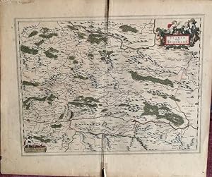
Copper-engraved map on laid paper, hand-coloured cartouches in upper right & lower left corners. Hand-colouring to entire map. Text on the verso in French, heading titled: Description Du Duche de STIRIE. Hand-coloured initial and tailpiece on verso. Signature mark on verso is HHHh. Plate size is 51cm x 38.5cm, on a sheet measuri…ng 58cm x 49.5cm. Old yellowed tape repair on verso at fold and edges, some splitting at fold, chipping at lower fold, pin holes to margins, very good condition. Probably from the French edition of Jansson's "Nouveau Theatre du Monde ou Nouvel Atlas" [c.1640]. Numbered in pencil at upper right with the numeral "90". From WorldCat's description: "The first French editions of the Atlas Novus appeared in three volumes in 1639, a year after the inaugural Latin version. The promptness with which the translation was readied meant that these were largely identical to the Latin original in material and structure, although several revisions were made to the order of contents to better tailor Jansson's offering to the Francophone market: thus, the French part of the Atlas was given new precedence over the Dutch one, and the Spanish and Portuguese chapters were detached from the French section in order to give the latter a stronger thematic coherence than it had previously had. Despite these similarities, the publication of the French editions was quite different from the Latin. After issuing the latter together, by 1639 Jansson and Hondius had resolved to print their own copies of the French title under their own imprints, and this division of resources and duplication of editions has resulted in a distinct, more complex publishing history. Indeed, variations in the stock of plates available to the former partners resulted in two quite separate classes of Atlas, with as many as twenty-five different maps between them, Jansson's typically the more up to date. Matters are further complicated by both Jansson and Hondius' habit of regularly updating their imprints for several years from 1639 onwards, resulting in confusing arrays of dates across the volumes of a single set." A map of Styria in Austria, based on Blaeu's map of 1635.
 More images
Published by Johannes Janssonius, Amsterdam 1648
- Map
Seller: Antiquariat Hieronymus, München, , GermanyAntiquariat Hieronymus
Contact seller5-star sellerCondition: Used - Very good
US$ 215.13
US$ 44.09 shippingShips from Germany to U.S.A.Quantity: 1 available
Condition: Gut. Gut. Kupferstich auf Passepartout montiert, altkoloriert. Blattgröße: 18,5 x 22 cm, Druckspiegel: 20,5 x 15,5 cm. . Kräftiger und klarer Druck auf leicht gebräuntem Papier, auf Passepartout montiert, insgesamt gut erhalten. Sehr schöne und seltene Landkarte von Aragon, aus der deutschen Ausgabe: "Atlas Minor. Das… ist: Eine kurze jedoch gründliche Beschreibung der ganzen Welt, in zwey Theile abgetheilt", Bd. 1, Amsterdam 1648. Landkarte, map, carte géographique, carta geografica, Spanien, Nordspanien, Spain, Espagnia, Espana, Spagna, Espagne, Arragon. 1200 Gramm.
 More images
Published by Amsterdam: Jansson, [c.1640]. 1640
Seller: William Matthews/The Haunted Bookshop, Sidney, BC, CanadaWilliam Matthews/The Haunted Bookshop
Contact seller5-star sellerCondition: Used
US$ 258.16
US$ 18.00 shippingShips from Canada to U.S.A.Quantity: 1 available
Copper-engraved map on laid paper, hand-coloured cartouches in lower right & left corners. Hand-colouring to entire map. Text on the verso in French, heading titled: LEON ET ASTURIE. Hand-coloured initials and tailpiece on verso. Signature mark on verso is E. Plate size is 49cm x 38cm, on a sheet measuring 59cm x 49.5cm. Old pap…er tape repair on verso at lower fold, some splitting along fold, clean and in very good condition. From Volume III of the French edition of Jansson's "Nouveau Theatre du Monde ou Nouvel Atlas" [c.1640]. Numbered in pencil at upper right with the numeral "4", which corresponds to this title on the contents list provided by WorldCat. From WorldCat's description: "The first French editions of the Atlas Novus appeared in three volumes in 1639, a year after the inaugural Latin version. The promptness with which the translation was readied meant that these were largely identical to the Latin original in material and structure, although several revisions were made to the order of contents to better tailor Jansson's offering to the Francophone market: thus, the French part of the Atlas was given new precedence over the Dutch one, and the Spanish and Portuguese chapters were detached from the French section in order to give the latter a stronger thematic coherence than it had previously had. Despite these similarities, the publication of the French editions was quite different from the Latin. After issuing the latter together, by 1639 Jansson and Hondius had resolved to print their own copies of the French title under their own imprints, and this division of resources and duplication of editions has resulted in a distinct, more complex publishing history. Indeed, variations in the stock of plates available to the former partners resulted in two quite separate classes of Atlas, with as many as twenty-five different maps between them, Jansson's typically the more up to date. Matters are further complicated by both Jansson and Hondius' habit of regularly updating their imprints for several years from 1639 onwards, resulting in confusing arrays of dates across the volumes of a single set." This issue is virtually identical to that issued by Blaeu in 1634, save for the addition of the second scale of distance in the cartouche/table at the lower right (Milliaria Germanica communia), and some minor reworking of the cartouche itself.

Published by Amsterdam 1656
- Art Print
Seller: Trillium Antique Prints & Rare Books, Franklin, TN, U.S.A.Trillium Antique Prints & Rare Books
Contact seller2-star sellerCondition: Used - Fine
US$ 275.00
US$ 10.00 shippingShips within U.S.A.Quantity: 1 available
Condition: Fine. This handsome, originally hand-colored map is from Jan Jansson's Novus Atlas, Das ist, Welt-beschreibung mit schonen newen auBfuhrlichen Taffeln inhaltende die Konigreiche und Lander des gantzen Erdreichs. This is the German edition of the work which was published in Amsterdam in 1656 by the author and Henricus…Hondius. Hondius & Jansson were prominent cartographers at the height of the Golden Age of Dutch cartography.Jan Janssonius (also known as Johann or Jan Jansson or Janszoon) (1588-1664) was part of an important family of Dutch publishers, printers, and booksellers. They were responsible for many important publications. Jan Jansson was a noted geographer in his own right. He married the daughter of another prominent mapmaker, Jodocus Hondius, and also worked with her brothers Henricus & Jodocus II.Henricus Hondius (1597-1651) & Jodocus Hondius (1593-1629) were Dutch engravers and mapmakers. They learned the trade from their father, Jodocus Hondius, an engraver and geographer. He was involved with the republishing of Mercator's atlas as well. The brothers worked closely together and took over their father's engraving business. He would later start his own shop in 1621 where he would eventually partner with Jan Janssonius and continued publishing Mercator's work where it would eventually be referred to as the Mercator-Hondius-Janssonius atlas. --- The work is in overall fair to very good condition. The work is prone to some image and text offfset, but in our opinion still present quite nicely showing signs of age. There may be some archival repairs to edges or fold. There may be a few minor imperfections or faint marks or fox marks to be expected with age. Please review the image carefully for condition and contact us with any questions. --- Paper Size ~ 23 1/4" by 19 1/4" (Fold Out).
 More images
Published by Amsterdam: Jansson, [c.1640]. 1640
Seller: William Matthews/The Haunted Bookshop, Sidney, BC, CanadaWilliam Matthews/The Haunted Bookshop
Contact seller5-star sellerCondition: Used
US$ 276.60
US$ 18.00 shippingShips from Canada to U.S.A.Quantity: 1 available
Copper-engraved map on laid paper, hand-coloured cartouches in upper right & left corners. Hand-colouring to entire map. Text on the verso in French, heading titled: BERGAMASC. Hand-coloured initial and tailpiece on verso. Signature mark on verso is L. Imprint at lower right: "Amstelodami Ioannes Ianssonius, Excudit." Plate size… is 49cm x 37.5cm, on a sheet measuring 59cm x 48cm. Old paper tape repair on verso at lower fold, yellowed tape on verso at upper fold and left margin, short tears to margins, very good condition. Probably from Volume III of the French edition of Jansson's "Nouveau Theatre du Monde ou Nouvel Atlas" [c.1640]. Numbered in pencil at upper right with the numeral "16". From WorldCat's description: "The first French editions of the Atlas Novus appeared in three volumes in 1639, a year after the inaugural Latin version. The promptness with which the translation was readied meant that these were largely identical to the Latin original in material and structure, although several revisions were made to the order of contents to better tailor Jansson's offering to the Francophone market: thus, the French part of the Atlas was given new precedence over the Dutch one, and the Spanish and Portuguese chapters were detached from the French section in order to give the latter a stronger thematic coherence than it had previously had. Despite these similarities, the publication of the French editions was quite different from the Latin. After issuing the latter together, by 1639 Jansson and Hondius had resolved to print their own copies of the French title under their own imprints, and this division of resources and duplication of editions has resulted in a distinct, more complex publishing history. Indeed, variations in the stock of plates available to the former partners resulted in two quite separate classes of Atlas, with as many as twenty-five different maps between them, Jansson's typically the more up to date. Matters are further complicated by both Jansson and Hondius' habit of regularly updating their imprints for several years from 1639 onwards, resulting in confusing arrays of dates across the volumes of a single set.".


