
Order Total (1 Item Items):
Shipping Destination:

Ayrouard Jacques (56 results)
Skip to main search results
Search filters
Product Type
- All Product Types
- Books (14)
- Magazines & Periodicals (No further results match this refinement)
- Comics (No further results match this refinement)
- Sheet Music (No further results match this refinement)
- Art, Prints & Posters (16)
- Photographs (No further results match this refinement)
- Maps (26)
- Manuscripts & Paper Collectibles (No further results match this refinement)
Condition Learn more
- New (No further results match this refinement)
- As New, Fine or Near Fine (11)
- Very Good or Good (16)
- Fair or Poor (No further results match this refinement)
- As Described (29)
Binding
- All Bindings
- Hardcover (9)
- Softcover (No further results match this refinement)
Collectible Attributes
- First Edition (2)
- Signed (No further results match this refinement)
- Dust Jacket (No further results match this refinement)
- Seller-Supplied Images (53)
- Not Print on Demand (56)
Language (3)
Free Shipping
- Free Shipping to U.S.A. (No further results match this refinement)
Seller Location
Seller Rating
-
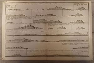
Linee di costa del Mediterraneo
Published by 1735 ca. ca. 1735, 1735
Seller: Libreria Antiquaria Pregliasco, Torino, TO, Italy
Seller rating 4 out of 5 stars

Condition: Good. Incisione in rame (mm 300x460 e margini). Curiosa composizione che raffigura le linee costiere di Lazio, Toscana, Campania. Tratta dall' atlante nautico "Recueil de plusieurs Plans des Ports et Rades et de quelques Cartes particuli�res de la Mer M�diterran�e, avec les figures des Terres remarquables pour les reconnoissances des Atterrages", edito tra il 1732 ed ll 1746. Jacques Ayrouard, idrografo francese, risulta attivo tra il 1730 ed il 1750; il raro atlante dei porti del Mediterraneo rimane la sua unica opera. Questo atlante nautico sarebbe stato successivamente disegnato da numerosi idrografi, in particolare William Heather che cita Ayrouard nel suo ?New Mediterranean Pilot? del 1802. L'incisore, Louis Corne, � noto a Tooley esclusivamente da questo lavoro. Bell'esemplare in buono stato di conservazione, numerata a mano nell'angolo superiore sinistro (N^ 75), buono stato di conservazione. The Map Collector, Issue 24, p.49. Book.
-

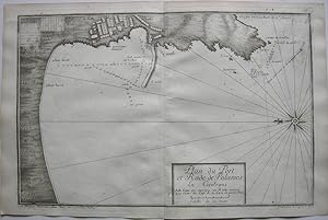
Plan du Port D'Ancio.
Published by AB et DC remerques pour suivre le canal des bancs à l'entrée. 1735 ca. ca. 1735, 1735
Seller: Libreria Antiquaria Pregliasco, Torino, TO, Italy
Seller rating 4 out of 5 stars
Condition: molto buono. Incisione in rame (mm 300x455 e margini). Firmata in lastra in basso a sinistra: ?Par Jacques Ayrouard pilote real avec privilege du Roy et grav� par Louis Corne. In alto a destra entro grande cartiglio iltitolo e le scala miliare. Tratta dall' atlante nautico "Recueil de plusieurs Plans des Ports et Rades et de quelques Cartes particuli�res de la Mer M�diterran�e, avec les figures des Terres remarquables pour les reconnoissances des Atterrages", edito tra il 1732 ed ll 1746. Jacques Ayrouard, idrografo francese, risulta attivo tra il 1730 ed il 1750; il raro atlante dei porti del Mediterraneo rimane la sua unica opera. Questo atlante nautico sarebbe stato successivamente disegnato da numerosi idrografi, in particolare William Heather che cita Ayrouard nel suo ?New Mediterranean Pilot? del 1802. L'incisore, Louis Corne, � noto a Tooley esclusivamente da questo lavoro.Bell'esemplare in buono stato di conservazione, numerata a mano nell'angolo superiore destro, qualche piccola macchietta rossa. The Map Collector, Issue 24, p.49. Book.
-

Plan du Port et Rade de Livourne
Published by AB ce une remarque pour faire route la nuite pour Livourne.1735 ca. ca. 1735, 1735
Seller: Libreria Antiquaria Pregliasco, Torino, TO, Italy
Seller rating 4 out of 5 stars
Condition: molto buono. Incisione in rame (mm 289x448 e margini). Firmata in lastra in basso a sinistra: ?Par Jacques Ayrouard pilote real avec privilege du Roy et grav� par Louis Corne".� Titolo entro cartiglio in alto al centro e scala miliare entro riquadro in basso a sinistra. Tratta dall' atlante nautico "Recueil de plusieurs Plans des Ports et Rades et de quelques Cartes particuli�res de la Mer M�diterran�e, avec les figures des Terres remarquables pour les reconnoissances des Atterrages", edito tra il 1732 ed ll 1746. Jacques Ayrouard, idrografo francese, risulta attivo tra il 1730 ed il 1750; il raro atlante dei porti del Mediterraneo rimane la sua unica opera. Questo atlante nautico sarebbe stato successivamente disegnato da numerosi idrografi, in particolare William Heather che cita Ayrouard nel suo ?New Mediterranean Pilot? del 1802. L'incisore, Louis Corne, � noto a Tooley esclusivamente da questo lavoro. Bell'esemplare in buono stato di conservazione, numerata a mano nell'angolo superiore sinistro, qualche piccola macchietta rossa. The Map Collector, Issue 24, p.49. Book.
-

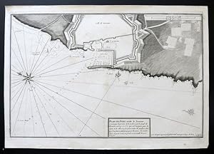
Plan de Civitavecchia.
Published by AB remarque pour marquer ou termine le grand fond. 1735 ca. ca. 1735, 1735
Seller: Libreria Antiquaria Pregliasco, Torino, TO, Italy
Seller rating 4 out of 5 stars
Condition: molto buono. Incisione in rame (mm 300x455 e margini). Firmata in lastra in basso a sinistra: ?Par Jacques Ayrouard pilote real avec privilege du Roy .� In alto a sinistra entro grande cartiglio il titolo e la scala miliare. Tratta dall' atlante nautico "Recueil de plusieurs Plans des Ports et Rades et de quelques Cartes particuli�res de la Mer M�diterran�e, avec les figures des Terres remarquables pour les reconnoissances des Atterrages", edito tra il 1732 ed ll 1746. Jacques Ayrouard, idrografo francese, risulta attivo tra il 1730 ed il 1750; il raro atlante dei porti del Mediterraneo rimane la sua unica opera. Questo atlante nautico sarebbe stato successivamente disegnato da numerosi idrografi, in particolare William Heather che cita Ayrouard nel suo ?New Mediterranean Pilot? del 1802. L'incisore, Louis Corne, � noto a Tooley esclusivamente da questo lavoro.Bell'esemplare in buono stato di conservazione, numerata a mano nell'angolo superiore destro. The Map Collector, Issue 24, p.49. Book.
-

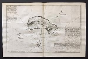
Linee di costa di Sardegna e Corsica
Published by 1735 ca. ca. 1735, 1735
Seller: Libreria Antiquaria Pregliasco, Torino, TO, Italy
Seller rating 4 out of 5 stars
Condition: Good. Incisione in rame (mm 293x452 e margini). Curiosa composizione che raffigura le linee costiere di Corsica e Sardegna. Tratta dall' atlante nautico "Recueil de plusieurs Plans des Ports et Rades et de quelques Cartes particuli�res de la Mer M�diterran�e, avec les figures des Terres remarquables pour les reconnoissances des Atterrages", edito tra il 1732 ed ll 1746. Jacques Ayrouard, idrografo francese, risulta attivo tra il 1730 ed il 1750; il raro atlante dei porti del Mediterraneo rimane la sua unica opera. Questo atlante nautico sarebbe stato successivamente disegnato da numerosi idrografi, in particolare William Heather che cita Ayrouard nel suo ?New Mediterranean Pilot? del 1802. L'incisore, Louis Corne, � noto a Tooley esclusivamente da questo lavoro. Bell'esemplare in buono stato di conservazione, numerata a mano nell'angolo superiore sinistro (N^ 73), qualche piccola macchietta rossa. The Map Collector, Issue 24, p.49. Book.
-

Linee di costa Sardegna (Porto Conte, Capo San Marco, Isola rossa, Capo Carbonare) e Lazio (Ponza, Palmarola, Circeo).
Published by 1735 ca. ca. 1735, 1735
Seller: Libreria Antiquaria Pregliasco, Torino, TO, Italy
Seller rating 4 out of 5 stars
Condition: molto buono. Incisione in rame (mm 293x452 e margini). Curiosa composizione che illustra le linee costiere della Sardegna e del Lazio.� Tra i posti raffigurati: l'isola di San Pietro,� Capo San Marco, Isola mal di ventre.). Tratta dall' atlante nautico "Recueil de plusieurs Plans des Ports et Rades et de quelques Cartes particuli�res de la Mer M�diterran�e, avec les figures des Terres remarquables pour les reconnoissances des Atterrages", edito tra il 1732 ed ll 1746. Jacques Ayrouard, idrografo francese, risulta attivo tra il 1730 ed il 1750; il raro atlante dei porti del Mediterraneo rimane la sua unica opera. Questo atlante nautico sarebbe stato successivamente disegnato da numerosi idrografi, in particolare William Heather che cita Ayrouard nel suo ?New Mediterranean Pilot? del 1802. L'incisore, Louis Corne, � noto a Tooley esclusivamente da questo lavoro. Bell'esemplare in buono stato di conservazione, numerata a mano nell'angolo superiore sinistro, qualche piccola macchietta rossa. The Map Collector, Issue 24, p.49. Book.
-

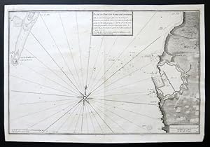
Plan du Port et de la Baye de Tarante
Published by Pour passer dans la petite passe il faut mettre les 2 clochers de St. Francois qui sont au sud de la ville. 1735 ca. ca. 1735, 1735
Seller: Libreria Antiquaria Pregliasco, Torino, TO, Italy
Seller rating 4 out of 5 stars
Condition: molto buono. Incisione in rame (mm 291x450 e margini). Firmata in lastra in basso a sinistra: ?Par Jacques Ayrouard pilote real avec privilege du Roy et grav� par Louis Corne". A destra entro grande cartiglio il titolo e le scala miliare.Tratta dall' atlante nautico "Recueil de plusieurs Plans des Ports et Rades et de quelques Cartes particuli�res de la Mer M�diterran�e, avec les figures des Terres remarquables pour les reconnoissances des Atterrages", edito tra il 1732 ed ll 1746. Jacques Ayrouard, idrografo francese, risulta attivo tra il 1730 ed il 1750; il raro atlante dei porti del Mediterraneo rimane la sua unica opera. Questo atlante nautico sarebbe stato successivamente disegnato da numerosi idrografi, in particolare William Heather che cita Ayrouard nel suo ?New Mediterranean Pilot? del 1802. L'incisore, Louis Corne, � noto a Tooley esclusivamente da questo lavoro. Bell'esemplare in buono stato di conservazione, numerata a mano nell'angolo superiore sinistro, qualche piccola macchietta rossa. The Map Collector, Issue 24, p.49. Book.
-

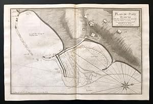
Plan de Porto Longon.
Published by AB remarque pour ne point avancer dans le fond du port. 1735 ca. ca. 1735, 1735
Seller: Libreria Antiquaria Pregliasco, Torino, TO, Italy
Seller rating 4 out of 5 stars
Condition: molto buono. Incisione in rame (mm 290x452 e margini). Firmata in lastra in basso a sinistra: ?Par Jacques Ayrouard pilote real avec privilege du Roy et grav� par Louis Corne". In basso a sinistra entro grande cartiglio il titolo e le scala miliare. Tratta dall' atlante nautico "Recueil de plusieurs Plans des Ports et Rades et de quelques Cartes particuli�res de la Mer M�diterran�e, avec les figures des Terres remarquables pour les reconnoissances des Atterrages", edito tra il 1732 ed ll 1746. Jacques Ayrouard, idrografo francese, risulta attivo tra il 1730 ed il 1750; il raro atlante dei porti del Mediterraneo rimane la sua unica opera. Questo atlante nautico sarebbe stato successivamente disegnato da numerosi idrografi, in particolare William Heather che cita Ayrouard nel suo ?New Mediterranean Pilot? del 1802. L'incisore, Louis Corne, � noto a Tooley esclusivamente da questo lavoro. Bell'esemplare in buono stato di conservazione, numerata a mano nell'angolo superiore sinistro, qualche piccola macchietta rossa. The Map Collector, Issue 24, p.49. Book.
-

Plan du Port de Ponce.
Published by A pointe ou y lia 9 prises pour amarrer B pointe ou u lia encore 9 prises et sur le bout du mole y lia 8 prises.1735 ca. ca. 1735, 1735
Seller: Libreria Antiquaria Pregliasco, Torino, TO, Italy
Seller rating 4 out of 5 stars
Condition: molto buono. Incisione in rame (mm 286x446 e margini). Firmata in lastra in basso a sinistra: ?Par Jacques Ayrouard pilote real .Titolo in alto a sinistra entro cartiglio rettangolare. Tratta dall' atlante nautico "Recueil de plusieurs Plans des Ports et Rades et de quelques Cartes particuli�res de la Mer M�diterran�e, avec les figures des Terres remarquables pour les reconnoissances des Atterrages", edito tra il 1732 ed ll 1746. Jacques Ayrouard, idrografo francese, risulta attivo tra il 1730 ed il 1750; il raro atlante dei porti del Mediterraneo rimane la sua unica opera. Questo atlante nautico sarebbe stato successivamente disegnato da numerosi idrografi, in particolare William Heather che cita Ayrouard nel suo ?New Mediterranean Pilot? del 1802. L'incisore, Louis Corne, � noto a Tooley esclusivamente da questo lavoro. Bell'esemplare in buono stato di conservazione, numerata a mano nell'angolo superiore sinistro. The Map Collector, Issue 24, p.49. Book.
-
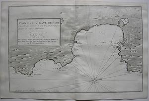
[Salou] Plan de la Baye de Salo en Catalogne
Published by Marseille, 1732
Seller: Bolivar Old Prints Anticuario, Barcelona, B, Spain
Seller rating 5 out of 5 stars

Condition: Good. [Descripci�n en espa�ol a continuaci�n] This nautical plan forms part of the work of the cartographer Jacques Ayrouard, a French sailor and engineer of the first half of the 18th century. Ayrouard is known for his maritime atlas titled Recueil de plusieurs plans des ports et rades de la mer M�diterran�e (published around 1730), which included detailed plans of numerous ports of the western Mediterranean. The author made it based on direct observations carried out during his voyages as a royal pilot. This plan represents the bay and cape of Salou, in the province of Tarragona, Catalonia. It is a strategic natural harbour and a notable anchorage area of Mediterranean navigation. On the map appear the nautical roadstead of Salou and, on the other side of the cape, the roadstead of Tarragona. It shows seabed levels with clear indications of safe areas for anchoring; it marks the coastal infrastructure, such as the watchtower of Cape Salou or the remains of the old fishing village and of the castle destroyed after the War of the Spanish Succession; and, in addition, the long sandy beaches, useful for flat landings, are clearly delineated. The plan includes a compass rose and orientation lines, as well as an explanatory text in a box on the left side of the map, where the quality of the bay of Salou as an anchorage is praised. Excellent state of preservation. -------------------- Este plano n�utico forma parte del trabajo del cart�grafo Jacques Ayrouard, un marino e ingeniero franc�s de la primera mitad del siglo XVIII. Ayrouard es conocido por su atlas mar�timo titulado Recueil de plusieurs plans des ports et rades de la mer M�diterran�e (publicado alrededor de 1730), el cual inclu�a planos detallados de numerosos puertos del Mediterr�neo occidental. El autor lo realiz� bas�ndose en observaciones directas realizadas durante sus viajes como piloto real. Este plano representa la bah�a y el cabo de Salou, en la provincia de Tarragona, Catalu�a. Es un puerto natural estrat�gico y zona de fondeadero destacada de la navegaci�n mediterr�nea. En el mapa aparece la rada n�utica de Salou y, al otro lado del cabo, la rada de Tarragona. Muestra niveles de fondo con indicaciones claras de zonas seguras para el anclaje; se�ala la infraestructura costera, como la torre de vigilancia del cabo de Salou o los restos del antiguo poblado pesquero y del castillo destruido tras la Guerra de Sucesi�n; y, adem�s, aparecen claramente delimitadas las largas playas arenosas, �tiles para desembarcos planos. El plano incluye una rosa de los vientos y l�neas de orientaci�n, adem�s de un texto explicativo en un recuadro en el lado izquierdo del mapa, donde se alaba la calidad como fondeadero de la bah�a de Salou. Gran estado de conservaci�n.
-
Plan de la Baye de Rose
Published by Paris, 1735
Seller: Bolivar Old Prints Anticuario, Barcelona, B, Spain
Seller rating 5 out of 5 stars
Condition: Very Good. [Descripci�n en espa�ol a continuaci�n] Original antique map of the Bay of Roses, on the Catalan coast, engraved by Jacques Ayrouard in 1735 and published in Marseille. The map depicts the coastal area between Cap de Creus and Begur, showing Roses and its gulf, Empuriabrava and l'Escala. The nautical chart is oriented to the west. It includes soundings expressed in fathoms to facilitate navigation towards the ports of Roses, Sant Pere Pescador, l'Estartit and Cadaqu�s. Jacques Ayrouard worked as an engraver specialising in the reproduction of maritime maps and military plans intended for French nautical publications during the first half of the 18th century. The engraving was executed on copper. -------------------- Mapa antiguo original de la bah�a de Rosas, situada en la costa catalana, grabado por Jacques Ayrouard en 1735 y editado en Marsella. El mapa representa la zona costera comprendida entre el Cap de Creux y Begur, mostrando Rosas y su golfo, Empuriabrava y l'Escala. La carta n�utica est� orientada al oeste. Incluye mediciones de sondas expresadas en brazas para facilitar la navegaci�n hacia los puertos de Rosas, Sant Pere Pescador, l'Estartit y Cadaqu�s. Jacques Ayrouard trabaj� como grabador especializado en la reproducci�n de mapas mar�timos y planos militares destinados a publicaciones n�uticas francesas durante la primera mitad del siglo XVIII. El grabado fue realizado en cobre.
-

PLAN DE LA BAYE DE ROSE et des c�tes des environs de puis le port de Cadequi� jusques au cap St. Sebastien.
Published by Louis Corne Sculp. [Par�s o Marsella, hacia 1735, 1735
Seller: FARR� Libreria Anticuaria, Barcelona, B, Spain
Seller rating 5 out of 5 stars
]. 32x48,5 cm. * Mapa perteneciente a la monumental obra titulada "Recueil de plusieurs ports et rades et de quelques cartes particul�res de la mer m�ditaerran�e." Catalu�a. Bah�a de Rosas. Roses. Cadaqu�s.
-
Plan de Porto Ferraro
Published by Marsiglia, 1735
Seller: libreria antiquaria perini Sas di Perini, Verona, VR, Italy
Seller rating 5 out of 5 stars
Art / Print / Poster
Incisione in rame, mm 310x470. Buon esemplare con qualche pieghetta e piccoli difetti marginali (strappetti e lievi mancanze).
-
Plan du golfe du Naples.
Published by Francia,, 1735
Seller: libreria antiquaria perini Sas di Perini, Verona, VR, Italy
Seller rating 5 out of 5 stars
Art / Print / Poster
Incisione in rame, 290x450. Ben conservato eccettuata una mancanza all'angolo inf. nel margine, lieve alone al margine inf. Nr.cat: 725.
-
Recueil de plusieurs Plans des Ports et Rades et de quelques Cartes particuli�res de la Mer M�diterran�e, avec les figures des Terres remarquables pour les reconnoissances des Atterrages
Published by [Paris or Marseille?] 1732-46, 1732
Seller: Peter Harrington. ABA/ ILAB., London, United Kingdom
Association Member: ABA ILAB PBFA
Seller rating 5 out of 5 stars
First Edition
US$ 17,244.30
US$ 29.47 shipping
Ships from United Kingdom to U.S.A.Quantity: 1 available
Add to basketFirst and only edition of this uncommon collection of charts, including the first printed chart of Monaco, a large folding map of Marseilles, and accurate charts of most of the ports, harbours and bays of the region. Ayrouard's work forms a working waggoner for the coast, recording soundings, anchorages, and pilotage notes on rocks and reefs, and includes a series of coastal profiles as a further aid to navigation. Many hydrographers later drew on this pilot, most notably William Heather, who cites Ayrouard in his New Mediterranean Pilot of 1802. Ayrouard dedicates the work to Jean Fr�d�rick Ph�lypeaux, comte de Maurepas, secretary to the royal household and minister of the navy in the court of Louis XV, who was prominent in attempts to introduce a more scientific approach to naval affairs until his exile in 1749 for writing derogatory epigrams about the king's mistress, Madame de Pompadour. The Conseil de la Marine, for whom this work was apparentlyproduced, wasfounded in 1720 as a central depository for maps, plans, journals, and memoirs relating to navigation. The hydrographer Ayrouard is unknown beyond the brief details he gives on the title where he describes himself as "Royal pilot of the King's Galleys", and explains that he prepared these charts on voyages he undertook on the coast, leading him to add further pilotage notes for the safe entry into certain of the harbours and roads ("avec les Remarques necessaires qu'il faut observer pour l'entr�e � Certains Ports et autres Endroits"). Similarly, Louis Corne, the engraver of these superbly detailed charts, was known to Tooley solely from this work. It is possible that this was a local production, perhaps in Marseille, hydrographer and engraver brought together under the aegis of the Conseil de la Marine to produce this pilot for the benefit of visiting French naval ships. Scarce: WorldCat records just six copies outside France. NMM 206; Shirley, British Library, M.AYR-1a.; LC 7862. The Map Collector, Issue 24, p.49, 'How Monaco evolved on maps and views', by David Lyon. Olivier, Pl.2495, No.27. Quarto (335 x 256 mm). Engraved title, 4 folding engraved charts, and 75 double-page, of which 10 are coastal profiles. Contemporary mottled sheep, raised bands, red morocco label to the second compartments, anchor devices gilt to the other five, edges sprinkled blue. Housed in a brown cloth flat-back box by the Chelsea Bindery. Somewhat rubbed, and with skilful restoration to the board edges, joints, and head and tail of the spine; tan-burn to the endpapers, folding map of Marseilles with clean tear, no loss, professionally repaired, light browning throughout, occasional marginal staining, but overall very good.
-
Recueil de plusieurs Plans des Ports et Rades et de quelques Cartes particuli�res de la Mer M�diterran�e, avec les figures des Terres remarquables pour les reconnoissances des Atterrages
Published by [Paris or Marseille?] 1732-46, 1732
Seller: Peter Harrington. ABA/ ILAB., London, United Kingdom
Association Member: ABA ILAB PBFA
Seller rating 5 out of 5 stars
First Edition
US$ 24,831.79
US$ 29.47 shipping
Ships from United Kingdom to U.S.A.Quantity: 1 available
Add to basketFirst and only edition of this uncommon collection of charts, including the first printed chart of Monaco, a large folding map of Marseilles, and accurate charts of most of the ports, harbours and bays of the region; this copy with the gilt arms of Charles Eug�ne Gabriel de La Croix de Castries, marquis de Castries (1727-1801), secretary of state for the navy from 1780 to 1787, and after 1783 marshal of France. Ayrouard's work forms a working waggoner for the coast, recording soundings, anchorages, and pilotage notes on rocks and reefs, and includes a series of coastal profiles as a further aid to navigation. Many hydrographers later drew on this pilot, most notably William Heather, who cites Ayrouard in his New Mediterranean Pilot of 1802. Ayrouard dedicates the work to Jean Fr�d�rick Ph�lypeaux, comte de Maurepas, secretary to the royal household and minister of the navy in the court of Louis XV, who was prominent in attempts to introduce a more scientific approach to naval affairs until his exile in 1749 for writing derogatory epigrams about the king's mistress, Madame de Pompadour. The Conseil de la Marine, for whom this work was apparentlyproduced, wasfounded in 1720 as a central depository for maps, plans, journals, and memoirs relating to navigation. The hydrographer Ayrouard is unknown beyond the brief details he gives on the title where he describes himself as "Royal pilot of the King's Galleys", and explains that he prepared these charts on voyages he undertook on the coast, leading him to add further pilotage notes for the safe entry into certain of the harbours and roads ("avec les Remarques necessaires qu'il faut observer pour l'entr�e � Certains Ports et autres Endroits"). Similarly, Louis Corne, the engraver of these superbly detailed charts, was known to Tooley solely from this work. It is possible that this was a local production, perhaps in Marseille, hydrographer and engraver brought together under the aegis of the Conseil de la Marine to produce this pilot for the benefit of visiting French naval ships. Scarce: WorldCat records just six copies outside France. NMM 206; Shirley, British Library, M.AYR-1a.; LC 7862. The Map Collector, Issue 24, p.49, 'How Monaco evolved on maps and views', by David Lyon. Olivier, Pl.2495, No.27. Quarto (340 x 270 mm). Engraved title, 70 double-page engraved charts, of which four are folding and two are printed on one mapsheet, and 10 double-page engraved coastal profiles. Contemporary calf, gilt arms to both boards of the marquis de Castries, rebacked with the original spine laid down, new red morocco label, raised bands, floral and foliate devices in the compartments, French fillet gilt panel to the boards, double rule edge-roll, marbled endpapers. A little rubbed, slight streaking on the boards, light toning, some offsetting and occasional spotting, but a very good copy.
-

Condition: ACEPTABLE. Recueil de plusiers plans des ports Mediterran. 1732/46 Par Jacques Ayrouard pilote real avec privilege du Roy Grav� par Louis Corne (2) Formato (cm): 45x29.
-
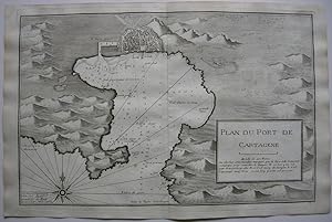
Plan de la Baye du Port de Cartagene.
Language: French
Seller: Antiquariat Werner Steinbei�, M�nchen, Germany
Seller rating 4 out of 5 stars
Map
Portolankarte von Cartagena, Murcia, Spanien. Orig. Kupferstich, gestochen von Louis Corne. aus: Jacques Ayrouard, "Recueil de Plusiers Plans des Ports et Rades et de Quelque Cartes Particulieres de la Mer Mediterran�e", Paris 1732--1746. Mit Meerestiefen und Ankerpl�tzen, oben Vogelschauplan von Cartagena, unten rechts Titelkartusche mit Erkl�rungen in Franz�sisch, Windrose im Meeresbereich, 29 x 44,5 cm Blattgr��e 32,5 x 50 cm.- gut erhaltenes Blatt Sprache: Franz�sisch Gewicht in Gramm: 550.
-
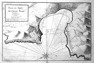
"Plan du Port de Porte Crose" - Port-Cros port Hafen map carte Karte
Language: German
Publication Date: 1732
Seller: Antiquariat Steffen V�lkel GmbH, Seubersdorf, Germany
Seller rating 5 out of 5 stars
Map
original Kupferstich-Karte von ca. 1732 aus dem sehr seltenen Atlas "Recueil de Plusiers Plans des Ports et Rades et de Quelque Cartes Particulieres de la Mer Mediterran�e" von Jacques Ayrouard - Blattmasse: ca. 53 x 35 cm - gut erhalten. | original copper engraved map from circa 1732 out of the very rare atlas "Recueil de Plusiers Plans des Ports et Rades et de Quelque Cartes Particulieres de la Mer Mediterran�e" by Jacques Ayrouard - good condition. | Dies ist ein Original! - Kein Nachdruck! - Keine Kopie! -- This is an original! No copy! - No reprint! // Wir, das Antiquariat Steffen V�lkel, kaufen und verkaufen alte B�cher, Handschriften, Zeichnungen, Autographen, Grafiken und Fotografien. Wir sind stets am Ankauf von kompletten Bibliotheken, Sammlungen und Nachl�ssen interessiert. Sprache: Deutsch Gewicht in Gramm: 1500.
-
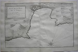
Plan de la Baye de St. Philiou en Catalogne.
Language: French
Seller: Antiquariat Werner Steinbei�, M�nchen, Germany
Seller rating 4 out of 5 stars
Map
Portolankarte von St. Philiou (katalan. Sant Feliu), Provinz Girona, Katalonien, Spanien. Orig. Kupferstich, gestochen von Louis Corne. aus: Jacques Ayrouard, "Recueil de Plusiers Plans des Ports et Rades et de Quelque Cartes Particulieres de la Mer Mediterran�e", Paris 1732--1746. Mit Meerestiefen und Ankerpl�tzen, oben links Titelkartusche, unten links Erkl�rungen in Franz�sisch, Windrose im Meeresbereich, 29 x 44,5 cm Blattgr��e 32,5 x 50 cm.- gut erhaltenes Blatt Sprache: Franz�sisch Gewicht in Gramm: 550.
-
Plan du Port et Rade de Palamos en Catalogne.
Language: French
Seller: Antiquariat Werner Steinbei�, M�nchen, Germany
Seller rating 4 out of 5 stars
Map
Portolankarte von Palamos, Baix Empord�, Katalonien, Spanien. Orig. Kupferstich, gestochen von H. Coussin. aus: Jacques Ayrouard, "Recueil de Plusiers Plans des Ports et Rades et de Quelque Cartes Particulieres de la Mer Mediterran�e", Paris 1732--1746. Mit Meerestiefen und Ankerpl�tzen, unten rechts Titelkartusche, Windrose im Meeresbereich, 29 x 44,5 cm Blattgr��e 32,5 x 50 cm.- gut erhaltenes Blatt Sprache: Franz�sisch Gewicht in Gramm: 550.
-

Plan du Port de Cadequie en Catalogne.
Language: French
Seller: Antiquariat Werner Steinbei�, M�nchen, Germany
Seller rating 4 out of 5 stars
Map
Portolankarte von Cadaques, Girona, Katalonien, Spanien. Orig. Kupferstich, gestochen von H. Coussin. aus: Jacques Ayrouard, "Recueil de Plusiers Plans des Ports et Rades et de Quelque Cartes Particulieres de la Mer Mediterran�e", Paris 1732--1746. Mit Meerestiefen und Ankerpl�tzen, unten links Titelkartusche, Windrose im Meeresbereich, 29 x 44,5 cm Blattgr��e 32,5 x 50 cm.- gut erhaltenes Blatt Sprache: Franz�sisch Gewicht in Gramm: 550.
-
Plan de la Baye de Rose et des Cotes des environs de puisle port de Cadequi� jusques au Cap St. Sebastien.
Language: French
Seller: Antiquariat Werner Steinbei�, M�nchen, Germany
Seller rating 4 out of 5 stars
Map
Portolankarte von Roses, Rosas, Girona, Katalonien, Spanien. Orig. Kupferstich, gestochen von Louis Corne. aus: Jacques Ayrouard, "Recueil de Plusiers Plans des Ports et Rades et de Quelque Cartes Particulieres de la Mer Mediterran�e", Paris 1732--1746. Mit Meerestiefen und Ankerpl�tzen, oben links Titelkartusche mit Erkl�rungen in Franz�sisch, Windrose im Meeresbereich, 29 x 44,5 cm Blattgr��e 32,5 x 50 cm.- gut erhaltenes Blatt Sprache: Franz�sisch Gewicht in Gramm: 550.
-
Plan du Port d'Ancio.
Publication Date: 1732
Seller: BOTTEGHINA D'ARTE GALLERIA K�PROS, Rosignano Solvay, LI, Italy
Seller rating 5 out of 5 stars
Art / Print / Poster
No legatura. Condition: Ottimo. Francia, 1732 - 1746 circa. Tratta dal "Recueil de plusieurs plans des ports et rades et de quelques cartes particuli�res de la mer Mediterranee" par Jacques Ayrouard pilote Real avec privilege du Roy. Incisione in rame all'acquaforte, b/n, cm 31 x 46,5 circa (alla lastra) pi� margini. Disegnata dal Ayrouard e incisa dal Corne, piano del porto di Anzio; si segnalano scandagli, pericoli per la navigazione e ancoraggi che si trovano lungo la costa. Poco si sa su Jacques Ayrouard, il quale pubblic� solo questo libro sui porti del Mediterraneo. Era un navigatore per la Marina Reale francese e dedic� il suo lavoro a Jean Federico Ph�lypeaux Comte de Maurepas, che fu Ministro della Marina per Luigi XV. Leggere zone di ingiallimento al centro del foglio, leggero sfondo di inchiostratura, peraltro foglio in ottimo stato di conservazione. .
-
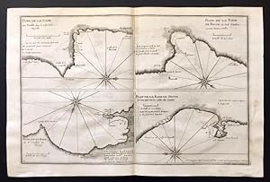
Plan de la Rade du Tuell� dans le Golfe de la Napoulle / Plan de la Rade de Bacon au sud d'Antibes a une bonne mille / Plan de la Rade de Sestri de Levant sur la cot� de Genes.
Publication Date: 1732
Seller: BOTTEGHINA D'ARTE GALLERIA K�PROS, Rosignano Solvay, LI, Italy
Seller rating 5 out of 5 stars
Art / Print / Poster
No legatura. Condition: Ottimo. Francia, 1732 - 1746 circa. Tratta dal "Recueil de plusieurs plans des ports et rades et de quelques cartes particuli�res de la mer Mediterranee" par Jacques Ayrouard pilote Real avec privilege du Roy. Incisione in rame all'acquaforte, b/n, cm 31 x 46,5 circa (alla lastra) pi� margini. Disegnata dal Ayrouard e incisa dal Corne, alcuni piani di porti del Mediterraneo tra cui quelli di Antibes e di Sestri Levante; si segnalano scandagli, pericoli per la navigazione e ancoraggi che si trovano lungo la costa. Poco si sa su Jacques Ayrouard, il quale pubblic� solo questo libro sui porti del Mediterraneo. Era un navigatore per la Marina Reale francese e dedic� il suo lavoro a Jean Federico Ph�lypeaux Comte de Maurepas, che fu Ministro della Marina per Luigi XV. Leggero sfondo di inchiostratura, foglio molto fine e in ottimo stato di conservazione.
-
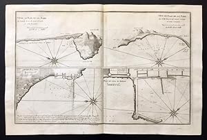
Vue en Plan de la Rade de Mont Cercele en cot� romaine / Plan du Mole de Naples.
Publication Date: 1732
Seller: BOTTEGHINA D'ARTE GALLERIA K�PROS, Rosignano Solvay, LI, Italy
Seller rating 5 out of 5 stars
Art / Print / Poster
No legatura. Condition: Ottimo. Francia, 1732 - 1746 circa. Tratta dal "Recueil de plusieurs plans des ports et rades et de quelques cartes particuli�res de la mer Mediterranee" par Jacques Ayrouard pilote Real avec privilege du Roy. Incisione in rame all'acquaforte, b/n, cm 31 x 46,5 circa (alla lastra) pi� margini. Disegnata dal Ayrouard e incisa dal Corne piano della rad del Monte Circeo e piano del Molo di Napoli; si segnalano scandagli, pericoli per la navigazione e ancoraggi che si trovano lungo la costa. Poco si sa su Jacques Ayrouard, il quale pubblic� solo questo libro sui porti del Mediterraneo. Era un navigatore per la Marina Reale francese e dedic� il suo lavoro a Jean Federico Ph�lypeaux Comte de Maurepas, che fu Ministro della Marina per Luigi XV. Leggero sfondo di inchiostratura, foglio molto fine e in ottimo stato di conservazione.
-
Plan de l'Isle Galita.
Publication Date: 1732
Seller: BOTTEGHINA D'ARTE GALLERIA K�PROS, Rosignano Solvay, LI, Italy
Seller rating 5 out of 5 stars
Art / Print / Poster
No legatura. Condition: Ottimo. Francia, 1732 - 1746 circa. Tratta dal "Recueil de plusieurs plans des ports et rades et de quelques cartes particuli�res de la mer Mediterranee" par Jacques Ayrouard pilote Real avec privilege du Roy. Incisione in rame all'acquaforte, b/n, cm 31 x 46,5 circa (alla lastra) pi� margini. Disegnata dal Ayrouard e incisa dal Corne, piano dell'Isola di Gaeta; si segnalano scandagli, pericoli per la navigazione e ancoraggi che si trovano lungo la costa. Poco si sa su Jacques Ayrouard, il quale pubblic� solo questo libro sui porti del Mediterraneo. Era un navigatore per la Marina Reale francese e dedic� il suo lavoro a Jean Federico Ph�lypeaux Comte de Maurepas, che fu Ministro della Marina per Luigi XV. Leggero sfondo di inchiostratura, foglio in ottimo stato di conservazione.
-
Plan du Port et Rade de Livourne.
Publication Date: 1732
Seller: BOTTEGHINA D'ARTE GALLERIA K�PROS, Rosignano Solvay, LI, Italy
Seller rating 5 out of 5 stars
Art / Print / Poster
No legatura. Condition: Buono. Francia, 1732 - 1746 circa. Tratta dal "Recueil de plusieurs plans des ports et rades et de quelques cartes particuli�res de la mer Mediterranee" par Jacques Ayrouard pilote Real avec privilege du Roy. Incisione in rame all'acquaforte, b/n, cm 30 x 46 circa (alla lastra) pi� margini. Disegnata dal Ayrouard e incisa dal Corne (in lastra in bs. a sn. "par Jacques Ayrouard pilote real avec privilege du Roy et grav� par L. Corne), piano del porto e rada di Livorno; si segnalano scandagli, pericoli per la navigazione e ancoraggi che si trovano lungo la costa. Poco si sa su Jacques Ayrouard, il quale pubblic� solo questo libro sui porti del Mediterraneo. Era un navigatore per la Marina Reale francese e dedic� il suo lavoro a Jean Federico Ph�lypeaux Comte de Maurepas, che fu Ministro della Marina per Luigi XV. Una sottile mancanza nell'angolo in basso a destra e alcuni leggeri punti di invecchiamento della carta, buona conservazione. .
-
Plan du Port et Rade de Livourne.
Publication Date: 1732
Seller: BOTTEGHINA D'ARTE GALLERIA K�PROS, Rosignano Solvay, LI, Italy
Seller rating 5 out of 5 stars
Art / Print / Poster
No legatura. Condition: Buono. rancia, 1732 - 1746 circa. Tratta dal "Recueil de plusieurs plans des ports et rades et de quelques cartes particuli�res de la mer Mediterranee" par Jacques Ayrouard pilote Real avec privilege du Roy. Incisione in rame all'acquaforte, b/n, cm 30 x 46 circa (alla lastra) pi� margini. Disegnata dal Ayrouard e incisa dal Corne (in lastra in bs. a ds. "par Jacques Ayrouard pilote real avec privilege du Roy L. Corne Sculp. 24), piano del porto e rada di Livorno; si segnalano scandagli, pericoli per la navigazione e ancoraggi che si trovano lungo la costa. Poco si sa su Jacques Ayrouard, il quale pubblic� solo questo libro sui porti del Mediterraneo. Era un navigatore per la Marina Reale francese e dedic� il suo lavoro a Jean Federico Ph�lypeaux Comte de Maurepas, che fu Ministro della Marina per Luigi XV. Alcuni leggeri punti di invecchiamento della carta, buona impressione e buona conservazione.
-
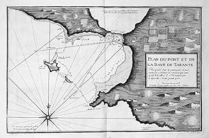
"Plan du Port et de la Baye de Tarante" - Tarent Taranto Puglia porto carta incisione Karte map
Language: German
Publication Date: 1732
Seller: Antiquariat Steffen V�lkel GmbH, Seubersdorf, Germany
Seller rating 5 out of 5 stars
Map
sehr seltene original Kupferstich-Karte von ca. 1732 aus dem sehr seltenen Atlas "Recueil de Plusiers Plans des Ports et Rades et de Quelque Cartes Particulieres de la Mer Mediterran�e" von Jacques Ayrouard - Blattmasse: ca. 53 x 35 cm - gut erhalten. | very rare original copper engraved map from circa 1732 out of the very rare atlas "Recueil de Plusiers Plans des Ports et Rades et de Quelque Cartes Particulieres de la Mer Mediterran�e" by Jacques Ayrouard - good condition. | Dies ist ein Original! - Kein Nachdruck! - Keine Kopie! -- This is an original! No copy! - No reprint! // Wir, das Antiquariat Steffen V�lkel, kaufen und verkaufen alte B�cher, Handschriften, Zeichnungen, Autographen, Grafiken und Fotografien. Wir sind stets am Ankauf von kompletten Bibliotheken, Sammlungen und Nachl�ssen interessiert. Sprache: Deutsch Gewicht in Gramm: 1500.
![Seller image for [Salou] Plan de la Baye de Salo en Catalogne for sale by Bolivar Old Prints Anticuario](https://pictures.abebooks.com/inventory/md/md32361011238.jpg)


