
Bertelli Donato (6 results)
 More images
Published by Venice: by the author, 1574. 1574
- Hardcover
- First Edition
Seller: Arader Galleries - AraderNYC, New York, NY, U.S.A.Arader Galleries - AraderNYC
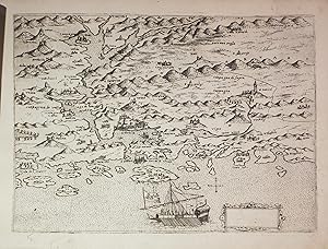
Contact seller5-star sellerHardcover. 1st Edition. BERTELLI, Donato (1558-1592). Civitatum aliquot insigniorum et locorum magis munitorum exacta delineatio. Venice: by the author, 1574. Small oblong folio (7 6/8 x 10 2/8 inches). Engraved title-page (lightly stained, one or two discreet repairs), 35 (of 68) engraved maps of Mediterranean islands, includin…g one folding general map of Italy, and 4 engraved plates by Domenico Zenoi, Paolo Forlani, Martino Rota, Natale Bonifacio e Fernando Bertelli (small repairs to 2 maps, occasional marginal light staining). Contemporary limp vellum, decorated with borders of gilt filets and central mannerist medallion, an early had has drawn an eye in the center of the front cover and written the title on spine (new endpapers, rubbed and lightly stained and creased, lacking four pairs of ties). First edition of a beautiful atlas of the Mediterranean Islands and coastline contested during the Ottoman-Venetian war in 1570-1573. An absolute master class in 16th century map-making during a transitional time as atlases started using standard formatting with a single printer. This edition drew from the talents of an array of engravers who executed incredibly dramatic war-time city views and maps. The styles of the individual engravers range from representing a cross-section of Venetian artisans working at that time. Velum cover with laced case end-bands intended as a temporary binding, instead expertly decorated to last in gilt bordering, with the central medallion blind stamped and elaborated in gold. A very odd but charmingly unique manuscript central eye in an exotic style. An obviously adored copy in excellent condition. Ottoman-Venetian war (1570-1573): Venice had been a major power in the eastern Mediterranean after taking control of Crete, the Morea (Peloponnese), and most of the Aegean islands from the Byzantine Empire during the fourth crusade in the early years of the 13th-century. Naturally Venice created trading posts throughout the area and for the next four hundred years battled with the Ottoman Empire for control. Concurrently the Ottomans were also at almost constant war with the Hapsburg Empire in the western Mediterranean. In 1516 the Habsburg Prince Karl was crowned King of Spain and became Charles I. In 1519 he became Holy Roman Emperor as Charles V (although he wasn't crowned as such until 1530), after which he united the Mediterranean and European - essentially Christian - lands against the 'infidel' armies of the Ottoman Empire. During the fourth Ottoman-Venetian war of 1570-1574 Venice irrevocably lost control of Cyprus, in spite of a decisive victory as part of the Holy League at Lepanto, led by Charles V's illegitimate son John of Austria, in 1571. Venice clung to its vestiges of power in the east until its loss of Crete to the Ottomans in 1669. The maps are of the Mediterranean with Candia (Crete) at the centre, Patmos, Sibenicho (Sibenik), Scardona, Radosich, and Bocca del Golfo de Cataro (Gulf of Kotor), on the Dalmatian coast, Scutari, Durazzo and Valona, in Albania, Dulcigno in Montenegro, Corfu, Scharpanto, Preveza, St. Maur, Modon (Methonion) and Brazo de Maina on the coast of Morea (Peloponnese), the Bay of Naples, Zante, Zafalonia (Cephalonia), Cerigo, Milo (Melos), Tine (Tinos), Nicasia, Samo, Scio, Negroponte (Euboea), De'Metileme (Mytilene), Rhodes, and Candia (Crete). There are also two or three detailed views of forts; a plate showing battleships; another of the siege of Giula in 1566; the siege of the Fort of Javarin (or Raab) on the banks of the Danube; a portrait of John of Austria (1547 - 1578), illegitimate son of Holy Roman Emperor Charles V, best known for his naval victory at the Battle of Lepanto in 1571 against the Ottoman Empire; a portrait of Pope Gregory XIII, and another of his arms; and one of the Turkish standard. Donato Bertelli was a printer and bookseller and might have been related to Ferrando Bertelli who in 1568 published another atlas with the same title, but in different format and conta.

Published by Gallipoli - Turchia
Seller: Sergio Trippini, Gavirate, VA, ItalySergio Trippini
Contact seller4-star sellerCondition: Used
US$ 353.08
US$ 54.85 shippingShips from Italy to U.S.A.Quantity: 1 available
Veduta della città di Gallipoli, nell'attuale provincia di CannaKale, situata lungo la sponda europea dello stretto dei Dardanelli. Secondo stato edito da Donato Bertelli ed inserito nel suo "Isolario". L'aggiunta della numerazione nell'angolo in basso a destra permette l'identificazione dell'edizione; questa nacque dalla modifi…ca dei rami originali di Camocio che erano stati acquistati dal Bertelli dopo la scomparsa del Camocio stesso durante l'epidemia pestilenziale che colpì la città di Venezia. Impressione marcata e vivace, ottimo lo stato di conservazione.

Published by Rodi - Grecia
Seller: Sergio Trippini, Gavirate, VA, ItalySergio Trippini
Contact seller4-star sellerCondition: Used
US$ 470.78
US$ 54.85 shippingShips from Italy to U.S.A.Quantity: 1 available
Veduta della città di Rodi, nell'omonima isola del mar Egeo. Secondo stato edito da Donato Bertelli ed inserito nel suo "Isolario". L'aggiunta della numerazione nell'angolo in basso a destra permette l'identificazione dell'edizione; questa nacque dalla modifica dei rami originali di Camocio che erano stati acquistati dal Bertell…i dopo la scomparsa del Camocio stesso durante l'epidemia pestilenziale che colpì la città di Venezia. Impressione marcata e vivace, ottimo lo stato di conservazione.

Il vero disegno et ritratto di Siena
Bertelli Donato (attivo a Venezia nella seconda metà del XVI Secolo)
Published by Venezia 1569
- Map
Seller: Libreria Ex Libris ALAI-ILAB/LILA member, Roma, RM, ItalyLibreria Ex Libris ALAI-ILAB/LILA member
Contact seller5-star sellerCondition: Used
US$ 1,530.02
US$ 34.28 shippingShips from Italy to U.S.A.Quantity: 1 available
Incisione originale su rame (cm. 27,5x19 più ampi margini bianchi). Carta con filigrana. Esemplare in ottimo stato di conservazione, ad ampi margini ed in nitida impressione. Rara. Bifolco-Ronca, p. 2317.

- Map
Seller: Altea Antique Maps, London, , United KingdomAltea Antique Maps
Contact seller5-star sellerCondition: Used
US$ 2,728.86
US$ 46.36 shippingShips from United Kingdom to U.S.A.Quantity: 1 available
Venice, c.1571. Contemporary hand colour. 180 x 270mm. Trimmed into image top right, narrow margins with a few nicks elsewhere, small tear. An early map of Venice in the form of a bird's-eye view, with the buildings shown in profile. Under the map is an extensive key. MORETTI: 24.

- Map
Seller: Altea Antique Maps, London, , United KingdomAltea Antique Maps
Contact seller5-star sellerCondition: Used
US$ 8,868.80
US$ 46.36 shippingShips from United Kingdom to U.S.A.Quantity: 1 available
Venice: Domenico Lovisa, 1693. Two sheet conjoined, total 485 x 740mm. A few signs of wear, tail of '9' of date scratched out. A map of northern Italy which, despite the title, depicts the River Po's drainage basin, so extends from Lake Geneva to Venice, Florence and Nice. Based on a map by Giacomo Gastaldi, this map was first p…ublished by Bertelli c.1573. In 1663 the map was reissued by Stefano Scolari, with this new, rather basic, title. This third and last state only has the date changed. A very rare map BIFOLCO & RONCA: 938, state iii of iii.


