Order Total (1 Item Items):
Shipping Destination:

Camocio (38 results)
Author:
camocio
Refine with Advanced Search
Skip to main search results
Search filters
Product Type
- All Product Types
- Books (4)
- Magazines & Periodicals (No further results match this refinement)
- Comics (No further results match this refinement)
- Sheet Music (No further results match this refinement)
- Art, Prints & Posters (5)
- Photographs (No further results match this refinement)
- Maps (29)
- Manuscripts & Paper Collectibles (No further results match this refinement)
Condition Learn more
- New (1)
- As New, Fine or Near Fine (20)
- Very Good or Good (8)
- Fair or Poor (No further results match this refinement)
- As Described (9)
Binding
- All Bindings
- Hardcover (No further results match this refinement)
- Softcover (No further results match this refinement)
Collectible Attributes
- First Edition (2)
- Signed (No further results match this refinement)
- Dust Jacket (No further results match this refinement)
- Seller-Supplied Images (37)
- Not Print on Demand (38)
Language (1)
Free Shipping
Seller Location
Seller Rating
-

Christian miracle events in Constantinople, A5
Published by Contentum Ltd., Larnaca, Cyprus
Art / Print / Poster
Loose Leaf. Condition: New. Reproduction. Original title: Christian miracle events in Constantinople German: Christliche Wunderereignisse in Konstantinopel French: Les �v�nements miracles chr�tiens � Constantinople Spanish: Los eventos milagrosos cristianos en Constantinopla High-quality fine-art reproduction based on an original work from the Rijksmuseum. Creation period: 16th century (1572). Professionally printed on premium fine-art paper (Photo Matt Fibre) in size A5. The motif is printed with a white border (museum-style presentation). No.
-

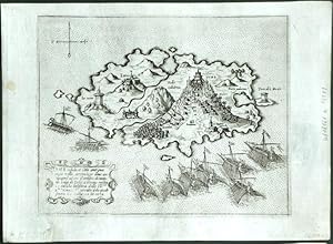
Galipoli Citta posta sopra il Mare nel stretto do Costantinopoli.
Published by Gallipoli - Turchia
Seller: Sergio Trippini, Gavirate, VA, Italy
Seller rating 4 out of 5 stars

Veduta della citt� di Gallipoli, nell'attuale provincia di CannaKale, situata lungo la sponda europea dello stretto dei Dardanelli. Secondo stato edito da Donato Bertelli ed inserito nel suo "Isolario". L'aggiunta della numerazione nell'angolo in basso a destra permette l'identificazione dell'edizione; questa nacque dalla modifica dei rami originali di Camocio che erano stati acquistati dal Bertelli dopo la scomparsa del Camocio stesso durante l'epidemia pestilenziale che colp� la citt� di Venezia. Impressione marcata e vivace, ottimo lo stato di conservazione.
-
Citta di Negroponte
Published by Venice, 1571
Seller: Antikvariat Krenek, Prag, Czech Republic
Association Member: ILAB
Seller rating 5 out of 5 stars

Map
US$ 445.55
US$ 16.72 shipping
Ships from Czech Republic to U.S.A.Quantity: 1 available
Add to basketCondition: Sehr gut. Chalkis, Euboea. "Citta di Negroponte". Orig. copperplate engraving, G. F. Camocio, 'Isole Famose .', Venice, ca. 1571. With engraved title, ornamental cartouche (blank) and 3 ships. 16,5:23 cm (6 1/2 x 9 inch.) on paper sized 19:26,5 cm. First state of the plate, without the number in the lower right corner. - A rare birds-eye-view of Chalcis or Chalkida, a chief town of the island of Euboea in Greece. Oriented to the Northeast. - Giovanni Francesco Camocio (1501-1575) was active as map publisher in Venice between 1558 and 1575. He was one of the most important mapmakers of the Lafreri School.
-
Cerigo Insula
Published by Venice, 1571
Seller: Antikvariat Krenek, Prag, Czech Republic
Association Member: ILAB
Seller rating 5 out of 5 stars
Map
US$ 445.55
US$ 16.72 shipping
Ships from Czech Republic to U.S.A.Quantity: 1 available
Add to basketCondition: Sehr gut. Kythira, Greece. "Cerigo Insula". Orig. copperplate engraving, G. F. Camocio, 'Isole Famose .', Venice, ca. 1571. With title cartouche. 15,5:20,5 cm (6 1/4 x 8 inch.) on paper sized 19:26,5 cm. Zacharakis: A catalogue of printed maps of Greece 1477-1800, 2nd edition, 1992; map nr. 511. - First state of the plate, without the number in the lower right corner. - A rare map of Kythira (also Cythera, Kythera and Kithira), an island in Greece lying opposite the south-eastern tip of the Peloponnese peninsula. Oriented to the Southeast. - Giovanni Francesco Camocio (1501-1575) was active as map publisher in Venice between 1558 and 1575. He was one of the most important mapmakers of the Lafreri School.
-
Antivari cita
Published by Venice, 1571
Seller: Antikvariat Krenek, Prag, Czech Republic
Association Member: ILAB
Seller rating 5 out of 5 stars
Map
US$ 445.55
US$ 16.72 shipping
Ships from Czech Republic to U.S.A.Quantity: 1 available
Add to basketCondition: Sehr gut. Bar (Montenegro). "Antivari cita in confine della Dalmatia et Albania . M.D.LXXI". Orig. copperplate engraving, G. F. Camocio, 'Isole Famose .', Venice, ca. 1571. With title-cartouche and 3 ships. 17:23 cm (6 3/4 x 9 inch.). First state of the plate, without the number in the lower right corner. - A rare birds-eye-view of Bar, a coastal town and seaport in southern Montenegro. - Giovanni Francesco Camocio (1501-1575) was active as map publisher in Venice between 1558 and 1575. He was one of the most important mapmakers of the Lafreri School.
-

Milo insula
Published by Venice, 1571
Seller: Antikvariat Krenek, Prag, Czech Republic
Association Member: ILAB
Seller rating 5 out of 5 stars
Map
US$ 445.55
US$ 16.72 shipping
Ships from Czech Republic to U.S.A.Quantity: 1 available
Add to basketCondition: Sehr gut. Milos, Greece. "Milo insula". Orig. copperplate engraving, G. F. Camocio, 'Isole Famose .', Venice, ca. 1571. With title cartouche. 20:15 cm (8 x 6 inch.) on paper sized 26,5:19 cm. Zacharakis: A catalogue of printed maps of Greece 1477-1800, 2nd edition, 1992; map nr. 523. - First state of the plate, without the number in the lower right corner. - A rare map of Milos or Melos, a volcanic Greek island in the Aegean Sea. Oriented to the Northeast. - Giovanni Francesco Camocio (1501-1575) was active as map publisher in Venice between 1558 and 1575. He was one of the most important mapmakers of the Lafreri School.
-

Curciola insula
Published by Venice, 1571
Seller: Antikvariat Krenek, Prag, Czech Republic
Association Member: ILAB
Seller rating 5 out of 5 stars
Map
US$ 445.55
US$ 16.72 shipping
Ships from Czech Republic to U.S.A.Quantity: 1 available
Add to basketCondition: Sehr gut. Korcula (Croatia). "Curciola insula". Orig. copperplate engraving, G. F. Camocio, 'Isole Famose .', Venice, ca. 1571. With title cartouche. 15,5:20,5 cm (6 1/4 x 8 inch.) on paper sized 19:26,5 cm. First state of the plate, without the number in the lower right corner. - A rare map of Korcula, a Croatian island in the Adriatic Sea. Oriented to the South. - Giovanni Francesco Camocio (1501-1575) was active as map publisher in Venice between 1558 and 1575. He was one of the most important mapmakers of the Lafreri School.
-

Metelin Mitilene
Published by Venice, 1571
Seller: Antikvariat Krenek, Prag, Czech Republic
Association Member: ILAB
Seller rating 5 out of 5 stars
Map
US$ 495.06
US$ 16.72 shipping
Ships from Czech Republic to U.S.A.Quantity: 1 available
Add to basketCondition: Sehr gut. Lesbos, Greece. "Metelin Mitilene .". Orig. copperplate engraving, G. F. Camocio, 'Isole Famose .', Venice, ca. 1571. With title cartouche and 4 ships. 22,5:17 cm (9 x 6 3/4 inch.). Zacharakis: A catalogue of printed maps of Greece 1477-1800, 2nd edition, 1992; map nr. 519. - First state of the plate, without the number in the lower right corner. - A rare map of Lesbos, a Greek island located in the northeastern Aegean Sea. Oriented to the East. - Giovanni Francesco Camocio (1501-1575) was active as map publisher in Venice between 1558 and 1575. He was one of the most important mapmakers of the Lafreri School.
-

Rodi Citta
Published by Rodi - Grecia
Seller: Sergio Trippini, Gavirate, VA, Italy
Seller rating 4 out of 5 stars
Veduta della citt� di Rodi, nell'omonima isola del mar Egeo. Secondo stato edito da Donato Bertelli ed inserito nel suo "Isolario". L'aggiunta della numerazione nell'angolo in basso a destra permette l'identificazione dell'edizione; questa nacque dalla modifica dei rami originali di Camocio che erano stati acquistati dal Bertelli dopo la scomparsa del Camocio stesso durante l'epidemia pestilenziale che colp� la citt� di Venezia. Impressione marcata e vivace, ottimo lo stato di conservazione.
-

Colfo di Lepanto
Published by Venice, 1571
Seller: Antikvariat Krenek, Prag, Czech Republic
Association Member: ILAB
Seller rating 5 out of 5 stars
Map
US$ 594.07
US$ 16.72 shipping
Ships from Czech Republic to U.S.A.Quantity: 1 available
Add to basketCondition: Sehr gut. Gulf of Corinth. "Colfo di Lepanto". Orig. copperplate engraving, G. F. Camocio, 'Isole Famose .', Venice, ca. 1571. With 2 cartouches. 15:20,5 cm (6 x 8 inch.) on paper sized 19,5:26 cm. Zacharakis: A catalogue of printed maps of Greece 1477-1800, 2nd edition, 1992; map nr. 507. - First state of the plate, without the number in the lower right corner. - A rare map of The Gulf of Corinth or the Corinthian Gulf, a deep inlet of the Ionian Sea separating the Peloponnese from western mainland Greece. - Giovanni Francesco Camocio (1501-1575) was active as map publisher in Venice between 1558 and 1575. He was one of the most important mapmakers of the Lafreri School.
-
Napoli Citta
Published by Venice, 1571
Seller: Antikvariat Krenek, Prag, Czech Republic
Association Member: ILAB
Seller rating 5 out of 5 stars
Map
US$ 594.07
US$ 16.72 shipping
Ships from Czech Republic to U.S.A.Quantity: 1 available
Add to basketCondition: Sehr gut. Nafplio, Peloponnese. "Napoli Citta nella Provincia della Morea". Orig. copperplate engraving, G. F. Camocio, 'Isole Famose .', Venice, ca. 1571. With title cartouche and many ships. 16:20 cm (6 1/4 x 8 inch.) on paper sized 19:26 cm. First state of the plate, without the number in the lower right corner. - A rare birds-eye-view of Nafplio, a seaport town in the Peloponnese in Greece. - Giovanni Francesco Camocio (1501-1575) was active as map publisher in Venice between 1558 and 1575. He was one of the most important mapmakers of the Lafreri School.
-
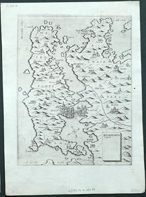
Negroponte Insula
Published by Venice, 1571
Seller: Antikvariat Krenek, Prag, Czech Republic
Association Member: ILAB
Seller rating 5 out of 5 stars
Map
US$ 594.07
US$ 16.72 shipping
Ships from Czech Republic to U.S.A.Quantity: 1 available
Add to basketCondition: Sehr gut. Euboea, Greece. "Negroponte Insula". Orig. copperplate engraving, G. F. Camocio, 'Isole Famose .', Venice, ca. 1571. With title cartouche. 20,5:16 cm (8 x 6 1/4 inch.) on paper sized 26,5:19,5 cm. Zacharakis: A catalogue of printed maps of Greece 1477-1800, 2nd edition, 1992; map nr. 518. - First state of the plate, without the number in the lower right corner. - A rare map of Euboea, a Greek island in the Aegean Sea. Oriented to the Southeast. - Giovanni Francesco Camocio (1501-1575) was active as map publisher in Venice between 1558 and 1575. He was one of the most important mapmakers of the Lafreri School.
-

Morea Peninsula
Published by Venice, 1571
Seller: Antikvariat Krenek, Prag, Czech Republic
Association Member: ILAB
Seller rating 5 out of 5 stars
Map
US$ 594.07
US$ 16.72 shipping
Ships from Czech Republic to U.S.A.Quantity: 1 available
Add to basketCondition: Sehr gut. Peloponnese, Greece. "Morea Peninsula .". Orig. copperplate engraving, G. F. Camocio, 'Isole Famose .', Venice, ca. 1571. With title cartouche, a compass rose and many ships. 21,5:15,5 cm (8 1/2 x 6 1/4 inch.) on paper sized 26:19 cm. Zacharakis: A catalogue of printed maps of Greece 1477-1800, 2nd edition, 1992; map nr. 503. - First state of the plate, without the number in the lower right corner. - A rare map of the Peloponnese or Peloponnesus. - Giovanni Francesco Camocio (1501-1575) was active as map publisher in Venice between 1558 and 1575. He was one of the most important mapmakers of the Lafreri School.
-

Samo nella Archipelago
Published by Venice, 1571
Seller: Antikvariat Krenek, Prag, Czech Republic
Association Member: ILAB
Seller rating 5 out of 5 stars
Map
US$ 594.07
US$ 16.72 shipping
Ships from Czech Republic to U.S.A.Quantity: 1 available
Add to basketCondition: Sehr gut. Samos (Greece). "Samo nella Archipelago". Orig. copperplate engraving, G. F. Camocio, 'Isole Famose .', Venice, ca. 1571. With ornamental title cartouche and a ship. 20,5:15,5 cm (8 x 6 1/4 inch.) on paper sized 26:19,5 cm. Zacharakis: A catalogue of printed maps of Greece 1477-1800, 2nd edition, 1992; map nr. 515. - First state of the plate, without the number in the lower right corner. - A rare map of Samos, a Greek island in the eastern Aegean Sea, south of Chios, north of Patmos and the Dodecanese, and off the coast of Asia Minor. Oriented to the Northwest. - Giovanni Francesco Camocio (1501-1575) was active as map publisher in Venice between 1558 and 1575. He was one of the most important mapmakers of the Lafreri School.
-
Zante insula
Published by Venice, 1571
Seller: Antikvariat Krenek, Prag, Czech Republic
Association Member: ILAB
Seller rating 5 out of 5 stars
Map
US$ 594.07
US$ 16.72 shipping
Ships from Czech Republic to U.S.A.Quantity: 1 available
Add to basketCondition: Sehr gut. Zakynthos, Greece. "Zante insula posta nel mare Mediteraneo .". Orig. copperplate engraving, G. F. Camocio, 'Isole Famose .', Venice, ca. 1571. With title cartouche. 17,5:21,5 cm (7 x 8 1/2 inch.) on paper sized 19,5:26,5 cm. Zacharakis: A catalogue of printed maps of Greece 1477-1800, 2nd edition, 1992; map nr. 508. - First state of the plate, without the number in the lower right corner. - A rare map of Zakynthos, a Greek island in the Ionian Sea. - Giovanni Francesco Camocio (1501-1575) was active as map publisher in Venice between 1558 and 1575. He was one of the most important mapmakers of the Lafreri School.
-
Zante insula posta nel mare Mediterraneo.
Published by Venezia, 1575
Seller: libreria antiquaria perini Sas di Perini, Verona, VR, Italy
Seller rating 5 out of 5 stars
Art / Print / Poster
Incisione in rame, mm 180x215 (foglio mm 190 x265). Tratta da "Isole famose, porti, fortezze e terre marittime sottoposte alla Serenissima Signoria di Venetia, ed altri Principi Christiani, et al Signor Turco, nouamente poste in luce". Stato I/II senza il numero in alto. Rara. Tra il 1560 ed 1575 Camocio pubblic� circa quaranta carte di grande formato e molte furono le carte di piccolo formato pubblicate sciolte tra il 1566 e il 1574, che andarono successivamente a formare il volume noto col nome "Isole famose, porti, fortezze e terre marittime". Le carte inserite nell'isolario di Camocio hanno la lastra ritoccata e un numero sequenziale aggiunto, mentre le prime prove sono caratterizzate dalla grande qualit? di stampa e dall'assenza del numero. Gli esemplari con la numerazione sono, invece, quelli inseriti nelle edizioni dell'isolario edite da Donato Bertelli - imprint In Venetia alla libreria del segno di San Marco. Tale edizione, sebbene priva di data, risale a dopo il 1575, anno in cui il Camocio scomparve durante l'epidemia di pestilenza a Venezia e gran parte della sua tipografia fu acquisita dal Bertelli. Raro primo stato, avanti la numerazione. Qualche leggera macchia, traccia di tarlo in basso alla piega centrale.Zacharakis (1992) 508; (2009), 782; Bifolco-Ronca (2018), 788 � 500Copper engraving, mm 180x215 (on sheet mm 190 x265). Rare first state before the number. From Camocio's "Isole Famose". This work, as was usual for Camocio and his other contemporary publishers, was on the market as loose map and later included in the "Isole famose, porti, fortezze e terre marittime sottoposte alla Serenissima Signoria di Venetia, ed altri Principi Christiani, et al Signor Turco, nouamente poste in luce. In Venetia alla libreria del segno di San Marco". The issue with the numbers are, instead, those inserted in the editions of the book published by Donato Bertelli - showing the imprint In Venetia alla libreria del segno di San Marco. This edition, although without date, dates back to after 1575, the year in which the Camocio disappeared during the pestilence epidemic in Venice and much of its typography was acquired by Bertelli. Zacharakis (1992) 508; (2009), 782; Bifolco-Ronca (2018), 788 Nr.cat: Cod 7992.
-
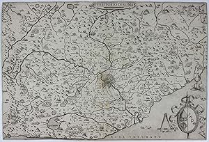
No binding. Condition: Very good. First. First edition, first state. [Venice: Camocio, 1559.] Single-sheet engraved map (18 15/16" x 12 13/16", 481mm x 326mm). Tanning verso (showing through to the recto a bit) along the center, indicating an erstwhile fold, and to the peripheries. Three pieces of old (hinging?) tape running along the upper edge of the verso, as well as a few filled splits and losses along the top and bottom. Slightly shaken impression at right. Presented in an acetate sleeve. Giovanni Francesco Camocio (active from the 1550's through the 1570's) was one of a group of Italian cartographer-booksellers known, a little artificially, as the "Lafreri school." His name has come to be associated with the present map because it was added in later states, this being the first of Bifolco-Ronca's four; the point is the absence of an address below the scale. Camocio appears to have cut a near-replica of an anonymous map dated 1557, which is itself based upon a 1556 map attributed to Vincenzo Luchini, all deriving ultimately from a 1547 map of Eufrosino della Volpaia. These maps all depict Lazio (the territory immediately surrounding Rome) with North at the upper-left corner (i.e., NE at the top). Visible within the city of Rome are the Castel Sant'Angelo, Pantheon and Colosseum. In the cartouche at bottom left are the impaled arms of the Camera Apostolica (the papal treasury; the crossed keys below the umbraculum in lieu of the papal tiara) and those of the city of Rome (S.P.Q.R., Senatus Populusque Romanus, "Roman Senate and People"). When the Catholic church is sede vacante --between the death of a pope and the election of his successor -- the Chamberlain as president of the Camera Apostolica is its temporal leader. Bifolco-Ronca locate this period sede vacante as that between the death of Paul IV 18 August 1559 and the election of Pius IV on Christmas day that year, the longest such period of the XVIc. Bifolco-Ronca III.1023 (pp. 2026-2027), , stato 1o.
-
![Seller image for CIPRO insula nobiliss.a ch[e] di grandezza tutte le altre eccede et detta Beata p[er] la sua mirabile fertilita di vino, grano, oglio, lino, ba[m]bagio, lane, legnami, vitrioli, sale, pece, metalli, et � divisa in 11 contadi, tiene di circuito mill. 550. longezza mill. 110. largezza mill. 65. Distante di Soria mill. 60. dalla Caramaniia mill. 50. Di Candia mill. 500. la principal citta regia e Nicossia distante di Famagosta mill: 38. for sale by libreria antiquaria perini Sas di Perini](https://pictures.abebooks.com/inventory/md/md22485660635.jpg)
CIPRO insula nobiliss.a ch[e] di grandezza tutte le altre eccede et detta Beata p[er] la sua mirabile fertilita di vino, grano, oglio, lino, ba[m]bagio, lane, legnami, vitrioli, sale, pece, metalli, et � divisa in 11 contadi, tiene di circuito mill. 550. longezza mill. 110. largezza mill. 65. Distante di Soria mill. 60. dalla Caramaniia mill. 50. Di Candia mill. 500. la principal citta regia e Nicossia distante di Famagosta mill: 38.
Published by Venezia, 1570
Seller: libreria antiquaria perini Sas di Perini, Verona, VR, Italy
Seller rating 5 out of 5 stars
Art / Print / Poster
Copper engraving, mm 200x159, second state numbered 70 at bottom right. Rare unsigned map by Camocio based on Forlani's map, with different orientation. The map is dated considering turkish gallions approaching the island before the war of Cyprus; from Isole famose, porti, fortezze e terre marittime sottoposte alla Serenissima Signoria di Venetia, ed altri Principi Christiani, et al Signor Turco, nouamente poste in luce. In Venetia alla libreria del segno di San Marco. Good condition, two restored tears in margin.Gallo (1950): p. 98, n. 70 e p. 99, n. 37; Stylianou (1980): n. 42, fig. 47; Zacharakis (1992): n. 522; Sweet Land of Cyprus (2003): n. 10; Bank of Cyprus (2003): n. 14; Zacharakis (2009): n. 796; Tolias (2011): n. 0407; Baynton-Williams (2016): pp. 76-77, n. 26; Bifolco-Ronca, "Cartografia e topografia italiana del XVI secolo. Catalogo ragionato delle opere a stampa" (scheduled for february 2018). Nr.cat: Cod 3451.
-

Cipro insula
Published by Venice, 1571
Seller: Antikvariat Krenek, Prag, Czech Republic
Association Member: ILAB
Seller rating 5 out of 5 stars
Map
US$ 2,475.29
US$ 16.72 shipping
Ships from Czech Republic to U.S.A.Quantity: 1 available
Add to basketCondition: Sehr gut. Cyprus. "Cipro insula". Orig. copperplate engraving, G. F. Camocio, 'Isole Famose .', Venice, ca. 1571. With title cartouche and many ships. 20:16 cm (8 x 6 1/4 inch.) on paper sized 27:19 cm. Zacharakis: A catalogue of printed maps of Greece 1477-1800; map nr. 522. - First state of the plate, without the page number in the lower right corner. - A rare map of Cyprus. Oriented to the East. - Giovanni Francesco Camocio (1501-1575) was active as map publisher in Venice between 1558 and 1575. He was one of the most important mapmakers of the Lafreri School.
-
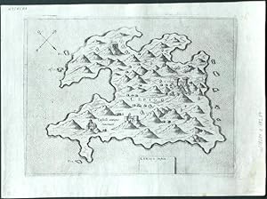
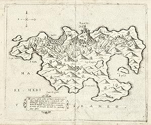
Tine insula
Published by Venice, 1571
Seller: Antikvariat Krenek, Prag, Czech Republic
Association Member: ILAB
Seller rating 5 out of 5 stars
Map
US$ 717.84
US$ 16.72 shipping
Ships from Czech Republic to U.S.A.Quantity: 1 available
Add to basketCondition: Sehr gut. Tinos, Greece. "Tine insula .". Orig. copperplate engraving, G. F. Camocio, 'Isole Famose .', Venice, ca. 1571. With title cartouche and many ships. 16:20,5 cm (6 1/4 x 8 inch.) on paper sized 19:26,5 cm. Zacharakis: A catalogue of printed maps of Greece 1477-1800, 2nd edition, 1992; map nr. 516. - First state of the plate, without the number in the lower right corner. - A rare map of Tinos, a Greek island situated in the Aegean Sea. - Giovanni Francesco Camocio (1501-1575) was active as map publisher in Venice between 1558 and 1575. He was one of the most important mapmakers of the Lafreri School.
-

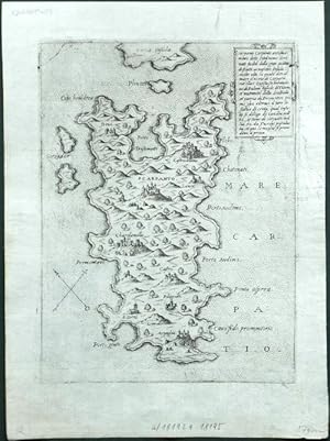
Rhodi insula
Published by Venice, 1571
Seller: Antikvariat Krenek, Prag, Czech Republic
Association Member: ILAB
Seller rating 5 out of 5 stars
Map
US$ 717.84
US$ 16.72 shipping
Ships from Czech Republic to U.S.A.Quantity: 1 available
Add to basketCondition: Sehr gut. Rhodes. "Rhodi insula et citta memorabile .". Orig. copperplate engraving from G. F. Camocio's 'Isole Famose .', Venice, 1571. With ornamental title cartouche and 7 ships. 20:15,5 cm (8 x 6 1/4 inch.) on paper sized 27:19 cm. Zacharakis: A catalogue of printed maps of Greece 1477-1800, 2nd edition, 1992; map nr. 521. - First state of the plate, without the number in the lower right corner. - A rare map of Rhodes, a Greek island in the Dodecanese islands, part of the South Aegean region - Giovanni Francesco Camocio (1501-1575) was active as map publisher in Venice between 1558 and 1575. He was one of the most important mapmakers of the Lafreri School.
-
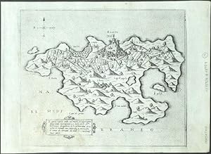
Cefalonia Insula
Published by Venice, 1571
Seller: Antikvariat Krenek, Prag, Czech Republic
Association Member: ILAB
Seller rating 5 out of 5 stars
Map
US$ 717.84
US$ 16.72 shipping
Ships from Czech Republic to U.S.A.Quantity: 1 available
Add to basketCondition: Sehr gut. Cephalonia, Greece. "Cefalonia Insula .". Orig. copperplate engraving, G. F. Camocio, 'Isole Famose .', Venice, ca. 1571. With title cartouche. 15,5:21 cm (6 1/4 x 8 1/4 inch.) on paper sized 19:26 cm. Zacharakis: A catalogue of printed maps of Greece 1477-1800, 2nd edition, 1992; map nr. 509. - First state of the plate, without the number in the lower right corner. - A rare map of Cephalonia or Kefalonia, formerly also known as Kefallinia or Kephallenia, the largest of the Ionian Islands in western Greece. - Giovanni Francesco Camocio (1501-1575) was active as map publisher in Venice between 1558 and 1575. He was one of the most important mapmakers of the Lafreri School.
-

Candia vel Creta insula
Published by Venice, 1571
Seller: Antikvariat Krenek, Prag, Czech Republic
Association Member: ILAB
Seller rating 5 out of 5 stars
Map
US$ 742.58
US$ 16.72 shipping
Ships from Czech Republic to U.S.A.Quantity: 1 available
Add to basketCondition: Sehr gut. Crete (Greece). "Candia vel Creta insula". Orig. copperplate engraving, G. F. Camocio, 'Isole Famose .', Venice, ca. 1571. With title cartouche, a compass rose and many ships. 19,5:16 cm (7 3/4 x 6 1/4 inch.) on paper sized 27:19 cm. Zacharakis: A catalogue of printed maps of Greece 1477-1800; map nr. 512. - First state of the plate, without the number in the lower right corner. - A rare map of Crete. Oriented to the East. - Giovanni Francesco Camocio (1501-1575) was active as map publisher in Venice between 1558 and 1575. He was one of the most important mapmakers of the Lafreri School.
-

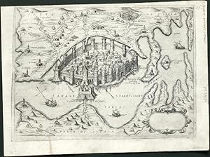
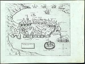
Constantinopoli
Published by Venice, 1571
Seller: Antikvariat Krenek, Prag, Czech Republic
Association Member: ILAB
Seller rating 5 out of 5 stars
Map
US$ 1,485.17
US$ 16.72 shipping
Ships from Czech Republic to U.S.A.Quantity: 1 available
Add to basketCondition: Sehr gut. Istanbul. "Constantinopoli". Orig. copperplate engraving, G. F. Camocio, 'Isole Famose .', Venice, ca. 1571. With engraved title, a wind-rose, many ships and explanatory notes at the bottom. 18,5:26 cm (7 1/4 x 10 1/4 inch.) on paper sized 19,5:27,5 cm. First state of the plate, without the number in the lower right corner. - A rare birds-eye-view of Istanbul. - Giovanni Francesco Camocio (1501-1575) was active as map publisher in Venice between 1558 and 1575. He was one of the most important mapmakers of the Lafreri School.
-
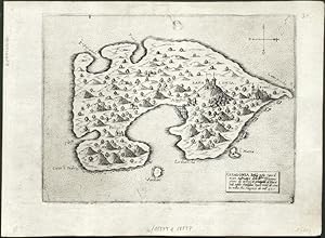
Scarapanto Carpanto Insula
Published by Venice, 1571
Seller: Antikvariat Krenek, Prag, Czech Republic
Association Member: ILAB
Seller rating 5 out of 5 stars
Map
US$ 717.84
US$ 16.72 shipping
Ships from Czech Republic to U.S.A.Quantity: 1 available
Add to basketCondition: Sehr gut. Karpathos (Greece). "Scarapanto Carpanto . Insula .". Orig. copperplate engraving, G. F. Camocio, 'Isole Famose .', Venice, ca. 1571. With title cartouche. 20,5:15 cm (8 x 6 inch.) on paper sized 26:19 cm. Zacharakis: A catalogue of printed maps of Greece 1477-1800, 2nd edition, 1992; map nr. 525. - First state of the plate, without the number in the lower right corner. - A rare map of Karpathos, one of the Greek Dodecanese islands, in the southeastern Aegean Sea. Oriented to the Northeast. - Giovanni Francesco Camocio (1501-1575) was active as map publisher in Venice between 1558 and 1575. He was one of the most important mapmakers of the Lafreri School.
-

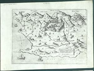
Corfu insula - copperplate map, Camocio, Isole Famose, 1571
Published by Venice, 1571
Seller: Antikvariat Krenek, Prag, Czech Republic
Association Member: ILAB
Seller rating 5 out of 5 stars
Map
US$ 742.58
US$ 16.72 shipping
Ships from Czech Republic to U.S.A.Quantity: 1 available
Add to basketCondition: Sehr gut. Corfu (Kerkyra - Greece). "Corfu insula antiquamente detta Malena .". Orig. copperplate engraving, G. F. Camocio, 'Isole Famose .', Venice, ca. 1571. With ornamental title cartouche and many ships. 19:15 cm (7 1/2 x 6 inch.) on paper sized 26:19,5 cm. Zacharakis: A catalogue of printed maps of Greece 1477-1800, 2nd edition, 1992; map nr. 504. - First state of the plate, without the number in the lower right corner. - A rare map of Corfu, a Greek island in the Ionian Sea. Oriented to the Southeast. - Giovanni Francesco Camocio (1501-1575) was active as map publisher in Venice between 1558 and 1575. He was one of the most important mapmakers of the Lafreri School.
-
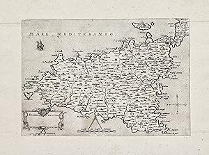
Sicilia Insula
Published by Venezia, 1571
Seller: libreria antiquaria perini Sas di Perini, Verona, VR, Italy
Seller rating 5 out of 5 stars
Art / Print / Poster
Incisione in rame, mm 146x210. Tratta da " Isole famose, porti, fortezze, e terre marittime ".Camocio fu una delle figure di spicco dell'editoria veneziana del periodo d'oro fra il 1558 ed il 1575. Nella sua bottega " Al segno della Piramide " in Merzeria pubblic� e vendette carte geografiche, soprattutto, e libri. Collabor� con tutti i maggiori professionisti del settore dal Forlani veronese al Gastaldi piemontese.Rifilata, come usanza dell'epoca voleva, alla linea di inquadramento, con aggiunta coeva di margini. Qualche leggera escoriazione e traccia del tempo, ma buon esemplare. Dufour-La Gumina, Imago Siciliae, 75 Nr.cat: Cod 3465.
-

Navigationi dil mondo Novo
Published by Venice: Giovanni Francesco Camocio, 1560., 1560
Seller: Arader Galleries - AraderNYC, New York, NY, U.S.A.
Seller rating 5 out of 5 stars
First Edition
1st Edition. Single sheet, float mounted and framed (sheet size: 12 x 17 1/8 inches; 9 4/8 x 14 2/8 inches to the neat line, full margins showing the plate mark). Fine engraved map of the Atlantic Ocean by Paolo Forlani, decorated with a fine central compass rose and numerous rhumb lines. First edition, first issue with the imprint dated "M.D.L.X". A very important map of the Atlantic Ocean, showing the coastlines of the Americas from Labrador to Brazil, western Europe and western Africa, north from the Tropic of Capricorn. It is derived from Nicolas de Nicolai's map which he published in his French translation of Pedro de Medina's 'Arte de Navegar' in 1554. Nicolas de Nicolai had travelled extensively in the service of the French King, "usually as a spy" (Burden). His map shows clearly his knowledge of the Cartier's voyages up the St. Lawrence River. Camocio published a number of Forlani's most important and celebrated maps. Following in the footsteps of his great colleague Giacomo Gastaldi, Paolo Forlani was a Venetian engraver and publisher of many significant maps and charts in the period of the Renaissance. It was in Italy, and particularly in Venice, that the map trade, which was to influence profoundly the course of cartographic history, was most highly developed during the first half of the 16th century. Venice was the most active port in the world, and successful trading expeditions necessitated accurate maps. Venetian ships made regular trading voyages to the Levant and into the Black Sea, to the ports of Spain and Portugal, and along the coasts of Western Europe. In the 15th century the city had already become a clearing-house for geographical information, and the development of cartography in the city was further impelled by the accomplishment of Venetian printers and engravers. Forlani was perhaps the most prolific producer of maps in the mid-16th century, and largely responsible for diffusing advanced geographical information to other parts of Europe. Burden 27; Karrow 59/4.1; Tooley:1939 no.77; Woodward:1990 no.3.01.
-
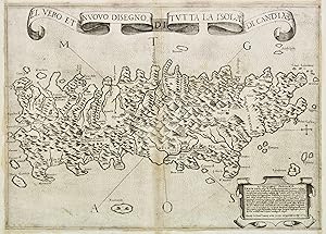
El vero et nuovo disegno di tutta la isola di Candia.
Published by Venezia, 1564
Seller: libreria antiquaria perini Sas di Perini, Verona, VR, Italy
Seller rating 5 out of 5 stars
Art / Print / Poster
Incisione in rame, 275x388. Stato unico.Rara carta "lafreriana" raffigurante Creta in una forma arcaica. La carta segue il modello Zorzi-Pagano del 1538, di cui risulta essere praticamente una copia incisa in rame; della carta esiste una ristampa a cura di Bertelli nel 1584 e una senza indirizzo posteriore. Anche in questa incisione l'orografia a mucchi di talpa risulta piuttosto fantasiosa; evidenziata l'idrografia e curiosamente indicato il labirinto di Cnosso al centro. Esemplare in ottimo stato di conservazione, eccettuata una traccia di umido nel margine sup., che sfiora la parte incisa. La carta � rifilata alla battuta della lastra ed i margini sono aggiunti all'epoca, secondo consuetudine per uniformare le dimensioni di carte diverse negli atlanti compositi. Nei punti di giunzione la colla ha arrossato la carta leggermente. Tooley 176; Meurer 92; Novacco, 25; Zacharakis, 5337; Zacharakis (2004), 15; Bifolco-Ronca (2018), 719Copper engraving, mm 272x382; fine impression; good condition, original glue traces, water stains in upper margin; remargined by the publisher, as very often, in order to bring all maps to the same size.Woodward attributes this map to Paolo Forlani. The map follows exactly the Zorzi-Pagano model of 1538, being almost a copy in copper. Famous map, traced in 38 Libraries, as it had been the most succesfull of the 60s. There is a second state of the map, dated 1584, by Donato Bertelli, and a later third one with his name erased. Tooley 176; Meurer 92; Novacco, 25; Zacharakis, 5337;Zacharakis (2004), 15; Bifolco-Ronca (2018), 719; Nr.cat: 4622.
-
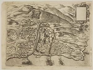
Castel Novo.
Publication Date: 1575
Seller: Altea Antique Maps, London, United Kingdom
Association Member: ABA ILAB PBFA
Seller rating 5 out of 5 stars
Map
US$ 413.16
US$ 46.80 shipping
Ships from United Kingdom to U.S.A.Quantity: 1 available
Add to basketNo Binding. Condition: Good. Venice: Ferrando and/or Donato Bertelli, c.1575. 170 x 220mm. . Herceg Novi, just south of Dubrovnik, made famous by the gallant yet unsuccessful defence of the fortress by the Spanish under Francisco de Sarmiento in 1539. This map was published in Camocio's 'Isole famose, porti fortezze e terre marittime sottoposte alla Ser.ma Sig.ria di Venezia', a description of the places claimed as subject to the Republic of Venice. A later state, with plate number.