Order Total (1 Item Items):
Shipping Destination:

Caniani (9 results)
Author:
caniani
Refine with Advanced Search
Skip to main search results
Search filters
Product Type
- All Product Types
- Books (4)
- Magazines & Periodicals (No further results match this refinement)
- Comics (No further results match this refinement)
- Sheet Music (No further results match this refinement)
- Art, Prints & Posters (1)
- Photographs (No further results match this refinement)
- Maps (4)
- Manuscripts & Paper Collectibles (No further results match this refinement)
Condition Learn more
- New (1)
- As New, Fine or Near Fine (No further results match this refinement)
- Very Good or Good (4)
- Fair or Poor (No further results match this refinement)
- As Described (4)
Binding
Collectible Attributes
- First Edition (No further results match this refinement)
- Signed (No further results match this refinement)
- Dust Jacket (No further results match this refinement)
- Seller-Supplied Images (8)
- Not Print on Demand (8)
Language (2)
Price
- Any Price
- Under US$ 25 (No further results match this refinement)
- US$ 25 to US$ 50
- Over US$ 50
Free Shipping
Seller Location
Seller Rating
-
Citt� di Milano.
Language: Italian
Published by Milan, 1808
Seller: HALEWOOD : ABA:ILAB : Booksellers :1867, PRESTON, United Kingdom
Association Member: ABA ILAB PBFA
Seller rating 5 out of 5 stars

US$ 1,231.75
US$ 11.83 shipping
Ships from United Kingdom to U.S.A.Quantity: 1 available
Add to basketSoft cover. Condition: Very Good. Large and detailed Map of Milan. Engraved by Giuseppe Caniani. measuring 81 x 57.5 cm. folding on linen, dissected into sixteen sections, complete with the original blue slip-case and protective sleeve. Excellent Example of this Scarce map.
-

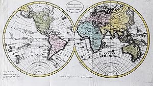
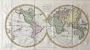
Europa Asia Ed Affrica Antiche E Moderne Per L'Intelligenza della Geografia Comparata.
Published by c.1806, Milan, Italy, 1806
Seller: Alexandre Antique Prints, Maps & Books, Toronto, ON, Canada
Seller rating 4 out of 5 stars

Map
Condition: Very Good. Early 19th century Italian World map., Size : 247x466 (mm), 9.72x18.35 (Inches), Hand Colored.
-
Carta Militare di Genova
Published by Genova
Seller: Sergio Trippini, Gavirate, VA, Italy
Seller rating 4 out of 5 stars
Carta intelata.
-

Carta Militare di Genova e suoi contorni. Caniani, Guiseppe Genoa & Liguria Copper Engraving, Uncolored published Milano 1825
Published by Gioachino Betalli [1825-30], Milano, 1825
Seller: Antiquariat Reinhold Berg eK Inh. R.Berg, Regensburg, Germany
Seller rating 5 out of 5 stars
Map
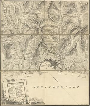
Other. Original antique copper engraving, uncolored, published 1825. Depicting Genoa & Liguria, this map is a fine example of 0s European cartography. Image: 580 by 450mm (22 by 17 inches). An attractive and historically significant 19th-century map for the discerning collector. Giuseppe Caniani was an Italian military cartographer active in the early 19th century. His military map of Genoa and its surroundings (c. 18251830) was produced for strategic purposes and reflects the ongoing interest in accurate topographic surveys of the Ligurian coastline following the Napoleonic period.An unusual and separately issued military map of Genua with its port and the surrounding into the mountains towards Pino and S. Lorenzo. The map includes many topographical details. The title cartouche with a table listing 33 gates, places and more. Equipped with a mileage scale and an anchor for decoration.A fine example from published Milano, sought after by collectors of antique maps of Italy, antique maps of Genoa, and antique copper engraving, uncoloreds for sale. In good condition. Colors well-preserved. Bottom margin with stains and water soiling, slightly affecting the image of the plan. A good impression with good margins. In very good condition. 580 by 450mm (22 by 17 inches). 580 by 450mm (22 by 17 inches).
-

Carta militare di Genova e suoi contorni
Published by Milano, 1830
Seller: libreria antiquaria perini Sas di Perini, Verona, VR, Italy
Seller rating 5 out of 5 stars
Art / Print / Poster
Incisione in rame 440x525. Carta topografica assai dettagliata di Genova e dintorni. Buon esemplare con angolo superiore destro e margine destro parzialmente rifatti, alcuni strappi restaurati di cui uno fino al limite della parte incisa. Lieve alone orizzontale fra la costa e l'indicazione " mediterraneo ". Nr.cat: Cod 1771.
-

Carta dell'Italia Superiore e di parte degli Stati limitrofi.
Published by Italia settentrionale
Seller: Sergio Trippini, Gavirate, VA, Italy
Seller rating 4 out of 5 stars
Carta geografica raffigurante l'Italia settentrionale e parte degli Stati limitrofi, ridotta dalla carta di Bacler d'Albe, presso il Deposito Generale della Guerra per ordine di S. E il Ministro della Guerra del Regno d'Italia. Il primo stato della carta risale al 1805, quando in seguito all'incoronazione di Napoleone a Re d'Italia, cess� la Repubblica Italiana di cui lo stesso Bonaparte era Presidente. All'epoca la carica di Ministro della Guerra era ricoperta dal Gen. Marie-Fran�ois Auguste de Caffarelli du Falga succeduto a Gen. Domenico Pino. La coloritura confinale mette in evidenza la parte di territori italiani parte dell'Impero Francese dopo l'incoronazione di Napoleone ad Imperatore avvenuta nel 1804. L'incisione � da considerarsi un secondo stato, al momento non risultano stati intermedi, presentando il Regno d'Italia alla sua massima espansione. Infatti, lungo il margine inferiore troviamo l'aggiunta del territorio del Dipartimento del Tronto il cui limite meridonale corre proprio lungo il corso del fiume Tronto. Piccoli segni del tempo, alcune pieghe ma senza fastidio. Rif: Marinelli 1881: 1430.
-
![Seller image for Arti e manifatture antichi e moderni in ornamenti di lusso (pubblicati da Bernardino Speluzzi e da Sisto Caniani.) 1842 [LeatherBound] for sale by True World of Books](https://pictures.abebooks.com/inventory/md/md31617764119.jpg)
LeatherBound. Condition: New. BOOKS ARE EXEMPT FROM IMPORT DUTIES AND TARIFFS; NO EXTRA CHARGES APPLY. LeatherBound edition. Condition: New. Reprinted from 1842 edition. Leather Binding on Spine and Corners with Golden leaf printing on spine. Bound in genuine leather with Satin ribbon page markers and Spine with raised gilt bands. A perfect gift for your loved ones. Pages: 265 NO changes have been made to the original text. This is NOT a retyped or an ocr'd reprint. Illustrations, Index, if any, are included in black and white. Each page is checked manually before printing. As this print on demand book is reprinted from a very old book, there could be some missing or flawed pages, but we always try to make the book as complete as possible. Fold-outs, if any, are not part of the book. If the original book was published in multiple volumes then this reprint is of only one volume, not the whole set. Sewing binding for longer life, where the book block is actually sewn (smythe sewn/section sewn) with thread before binding which results in a more durable type of binding. Pages: 265.
-
Mappamondo o Carta Generale della Terra
Publication Date: 1790
Seller: LUX IN ART di Ermanno Bertelli, Bologna, BO, Italy
Seller rating 5 out of 5 stars
Map
Condition: buona. Incisione in rame con coloritura d'epoca. Bell'incisione ritraente il globo della Terra con bella coloritura ed in buono stato di conservazione. Formato: 210x350mm.
-
Mappamondo o Carta Generale della Terra
Publication Date: 1780
Seller: LUX IN ART di Ermanno Bertelli, Bologna, BO, Italy
Seller rating 5 out of 5 stars
Map
Condition: buona. Incisione in rame con coloritura. Bell'incisione ritraente il globo della Terra con bella coloritura ed in buono stato di conservazione. Formato: 210x370mm.