Order Total (1 Item Items):
Shipping Destination:

Captain Daniel Ross (3 results)
Skip to main search results
Search filters
Product Type
- All Product Types
- Books (2)
- Magazines & Periodicals (No further results match this refinement)
- Comics (No further results match this refinement)
- Sheet Music (No further results match this refinement)
- Art, Prints & Posters (No further results match this refinement)
- Photographs (No further results match this refinement)
- Maps (1)
- Manuscripts & Paper Collectibles (No further results match this refinement)
Condition Learn more
- New (No further results match this refinement)
- As New, Fine or Near Fine (No further results match this refinement)
- Very Good or Good (1)
- Fair or Poor (No further results match this refinement)
- As Described (2)
Binding
- All Bindings
- Hardcover (No further results match this refinement)
- Softcover (No further results match this refinement)
Collectible Attributes
- First Edition (No further results match this refinement)
- Signed (No further results match this refinement)
- Dust Jacket (No further results match this refinement)
- Seller-Supplied Images (2)
- Not Print on Demand (3)
Language (2)
Price
- Any Price
- Under US$ 25 (No further results match this refinement)
- US$ 25 to US$ 50
- Over US$ 50
Free Shipping
- Free Shipping to U.S.A. (No further results match this refinement)
Seller Location
Seller Rating
-

Captain Ross, John (1777-1856)- An Original Antique Black & White Sketch
Language: English
Published by Frasers Magazine, 1880
Seller: K Books Ltd ABA ILAB, York, YORKS, United Kingdom
Association Member: ABA ILAB PBFA
Seller rating 5 out of 5 stars

US$ 48.36
US$ 26.16 shipping
Ships from United Kingdom to U.S.A.Quantity: 1 available
Add to basketNo Binding. Condition: Very Good. Daniel MacLise (illustrator). An attractive black and white charactersitic sketch of an eminent author. This is an excellent opportunity to purchase this splendid original print. Arctic explorer of Baffin's Bay fame.
-
China Sea - Sheet I [and] Sheet II To Capt. D. Ross and His Assistants Lieut. P. Maugham, J. Crawford, and J. Houghton, of the Bombay Marine; Who under the auspices of the Hon.ble East India Company, having performed with Arduous Zeal a difficult and dangerous Exploration of the China Sea, so Essential to the safety of Navigation, This Chart - Although with an extension of Limits being Chiefly Construction from Their Valuable Surveys, is now Inscribed as a Tribute due to Those Laudable Exertions By their Sincerely Obliged Friend, James Horsburgh.
Published by James Horsburgh, Hydrographer to the Hon.ble East India Company, October 1st, 1821. with Additions to 1846 [but 1849 - and -] 1 Feb.y 1823,. Additions to 1850., London,, 1821
Seller: Daniel Crouch Rare Books Ltd, London, United Kingdom
Association Member: ABA ILAB PBFA
Seller rating 4 out of 5 stars

Map
US$ 4,006.83
US$ 26.83 shipping
Ships from United Kingdom to U.S.A.Quantity: 1 available
Add to basketThe best route towards China for leaky crazy ships during the strength of the S.W. Monsoon Two engraved charts, laid down on linen. Exceptionally detailed, large-scale charts of parts of Southeast Asia and the China Sea, including Singapore, Malay, Borneo, Cambodia, Cochin- China, Hainan, southeast China, Taiwan, and Luzon in the Philippines. The chart boldly indicates the "best" sea-routes to and from Batavia to China, depending on the season, and the condition of the vessel. "The best route towards China for leaky crazy ships during the strength of the S.W. Monsoon" plots a course that hugs the shores of the Malay Peninsula and Cambodia. The islands of the "Sincapour Strait", including "Sincapour", in shown in great detail, with numerous depth soundings, and coastal profiles. Printed updates, to the location of dangerous shoals in particular, appear to 1849. The current charts were first published in 1821 and 1823, respectively, as part of a plan to monetize his experience by producing a series of charts of the China Sea, Malacca Strait, and Bombay Harbour. Touchingly, the lower sheet shows the "Pedro Branco Light" that was built as a commemoration to Horsburgh upon his death in 1836, at the eastern entrance to the Strait of Singapore. The map is dedicated to Captain Daniel Ross (1780-1849) and his team of hydrographers of the Bombay Marine. In 1807, Ross was tasked by the East India Company to survey the China Seas. He spent nine years surveying the coast between 1807 and 1816, and then spent a further four years charting the seas between 1816 and 1820. On his return to England in 1821 he was rewarded with a cash sum of �1,500 from the East India Company, for his tireless work out in the Far East. He would later appear before a government Select Committee investigating the possibilities of increasing the Britain's trade with China. With the tracks of many voyages from the Singapore Strait to Canton, and then on to Manila, plotted, and annotated in the same hand, in pen and different coloured ink, dated: 1856, 1858, 1859, 1860, and 1864. Provenance: With the tracks of many voyages from the Singapore Strait to Canton, and then on to Manila, plotted, and annotated in the same hand, in pen and different coloured ink, dated: 1856, 1858, 1859, 1860, and 1864.
-
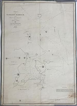
A Plan of Hastings Harbour, in the Mergui Archipelago, and the Adjacent Islands, by Capt. Danl. Ross, F.R.S. Marine Surveyor General 1828
Published by James Horsburgh, London, 1829
Seller: Antipodean Books, Maps & Prints, ABAA, Garrison, NY, U.S.A.
Association Member: ABAA ANZAAB ESA ILAB
Seller rating 3 out of 5 stars

Maps. Condition: Otherwise very good condition. A rare map of islands in the Andaman Sea, Burma, surveyed by Daniel Ross, known as the "Father of the Indian Surveys." Captain Ross was engaged in surveying the coast of China from 1806-1820. His highly accurate & trigonometrical charts were published as they were completed, and the whole were incorporated into Horsburgh's general charts. In 1823, he became the Marine Surveyor General. Clements Markham, in "A Memoir on the Indian Surveys" (1871) stated that "During the Burmese War from 1823 to 1826 the useful operations under his superintendency were interrupted." and despite a "fit of ruinous economy" in 1828, Ross resumed his good work and in 1830, again had two brigs (surveying) in the Mergui Archipelago. The map was surveyed on the heels of the First Burmese War, perhaps with thoughts of being prepared for another war, and another, which fortunately did not start again until the 1850s. The map shows the islands Hasting's, St. Matthew's and St. Luke's, now named Hastings, Zadetkalay and Zadetkyi. Other islands include Pine Tree, Russell's, Three Hill, Phipp's, Barwell's and Horse Shoe Island, mostly appearing as Kawthaung on Google maps. James Horsburgh (1762 -1836) was a Scottish hydrographer who worked for the British East India Company and charted much of South East Asia in the late 18th and early 19th centuries. When he retired from the sea in 1806, he produced a Sailing Directory to the East and in 1810 was appointed as hydrographer to the East India Company where he revised the Directory, publishing editions in 1816-7, 1826-7, and 1836. After his death the Admiralty took up the Directory and released editions in 1841, 1852, 1855, and 1864. his charts eventually passed to the Admiralty Hydrographic Office who also reissued them. Sea chart backed on linen and edged in blue silk, 19 1/2 x 22". Some spotting in the lower right corner (water) but otherwise remarkable clean and fresh, including the silk ties. "Engraved by Richard Bateman" beneath the title. The British Library holds a copy (BLL01004857047) but not noted on OCLC.

![Seller image for China Sea - Sheet I [and] Sheet II To Capt. D. Ross and His Assistants Lieut. P. Maugham, J. Crawford, and J. Houghton, of the Bombay Marine; Who under the auspices of the Hon.ble East India Company, having performed with Arduous Zeal a difficult and dangerous Exploration of the China Sea, so Essential to the safety of Navigation, This Chart - Although with an extension of Limits being Chiefly Construction from Their Valuable Surveys, is now Inscribed as a Tribute due to Those Laudable Exertions By their Sincerely Obliged Friend, James Horsburgh. for sale by Daniel Crouch Rare Books Ltd](https://pictures.abebooks.com/inventory/md/md31133266231.jpg)