

Order Total (1 Item Items):
Shipping Destination:

China Macao (20 results)
Skip to main search results
Search filters
Product Type
- All Product Types
- Books (10)
- Magazines & Periodicals (No further results match this refinement)
- Comics (No further results match this refinement)
- Sheet Music (No further results match this refinement)
- Art, Prints & Posters (4)
- Photographs (No further results match this refinement)
- Maps (6)
- Manuscripts & Paper Collectibles (No further results match this refinement)
Condition Learn more
- New (5)
- As New, Fine or Near Fine (No further results match this refinement)
- Very Good or Good (3)
- Fair or Poor (No further results match this refinement)
- As Described (12)
Binding
Collectible Attributes
- First Edition (No further results match this refinement)
- Signed (No further results match this refinement)
- Dust Jacket (No further results match this refinement)
- Seller-Supplied Images (17)
- Not Print on Demand (18)
Language (3)
Price
- Any Price
- Under US$ 25 (No further results match this refinement)
- US$ 25 to US$ 50
- Over US$ 50
Free Shipping
- Free Shipping to U.S.A. (No further results match this refinement)
Seller Location
Seller Rating
-

China\ s Approach to Central Asia: The Shanghai Co-Operation Organisation
Book 147 of 233: Routledge Contemporary ChinaUS$ 234.77
US$ 56.15 shipping
Ships from Germany to U.S.A.Quantity: Over 20 available
Add to basketGebunden. Condition: New. Weiqing Song is an Associate Professor in the Department of Political Science at the University of Macau, China.This book examines, comprehensively, the Shanghai Co-operation Organisation, the regional organisation which c.
-

US$ 259.98
US$ 56.15 shipping
Ships from Germany to U.S.A.Quantity: Over 20 available
Add to basketCondition: New.
-

The Private Justice Gap: Devising a Legal Defence to the Harm of Judging
Language: English
Published by Taylor & Francis Ltd, 2026
ISBN 10: 1041140584 ISBN 13: 9781041140580
US$ 316.37
US$ 16.51 shipping
Ships from United Kingdom to U.S.A.Quantity: 2 available
Add to basketHardcover. Condition: Brand New. 188 pages. 9.18x6.12x9.45 inches. In Stock.
-

Chinese Temple Macao
Published by P. S. Duval, Philadelphia, 1856
Seller: Antipodean Books, Maps & Prints, ABAA, Garrison, NY, U.S.A.
Association Member: ABAA ANZAAB ESA ILAB
Seller rating 4 out of 5 stars

Condition: Very good condition. A view of the important Chinese Temple in Macao taken from the water with a junk in the foreground and many sampans & junks moored in front of it, with visitors and temple flags waving. This lithograph appeared in Francis Hawk's 'Narrative of the Expedition of an American Squadron to the China Seas and Japan Performed in the years 1852, 1853, and 1854, under the Command of Commodore M. C. Perry'. View 6 x 8 3/4" on sheet 8 1/2 x 11 1/2".
-

Macao From Penha Hill
Published by P. S. Duval, Philadelphia, 1856
Seller: Antipodean Books, Maps & Prints, ABAA, Garrison, NY, U.S.A.
Association Member: ABAA ANZAAB ESA ILAB
Seller rating 4 out of 5 stars
Condition: Very good overall. Hand colored lithograph of Macao harbor after the artist Wilhelm Heine. With masted sailing vessels in the harbor, church spires, dwellings, and flag flying from a hilltop fortress. From Francis Hawk's 'Narrative of the Expedition of an American Squadron to the China Seas and Japan Performed in the years 1852, 1853, and 1854, under the Command of Commodore M. C. Perry'. 6 x 8 3/4 inches on sheet 8 1/2 x 11 1/4 inches. Mild fox spotting.
-
Macao From Penha Hill
Published by P. S. Duval, Philadelphia, 1856
Seller: Antipodean Books, Maps & Prints, ABAA, Garrison, NY, U.S.A.
Association Member: ABAA ANZAAB ESA ILAB
Seller rating 4 out of 5 stars
Condition: Very good overall. Hand colored lithograph of Macao harbor after the artist Wilhelm Heine. With masted sailing vessels in the harbor, church spires, dwellings, and flag flying from a hilltop fortress. From Francis Hawk's 'Narrative of the Expedition of an American Squadron to the China Seas and Japan Performed in the years 1852, 1853, and 1854, under the Command of Commodore M. C. Perry'. 6 x 8 3/4 inches on sheet 8 1/2 x 11 1/4 inches. A few small marks at margins, especially at right side, which do not affect image.
-
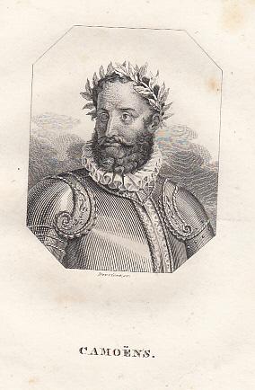
Porträt. Brustb. nach hr., Kopf nach l. gewandt, in Rüstung mit Lorbeerkranz, vor angedeutetem Hintergrund in achteck. Einfassung. Kupferstich von Wilhelm Devrient, 18,5 x 12,5 cm, um 1830.
Seller: Antiquariat Michael Eschmann, Groß-Gerau, Germany
Seller rating 5 out of 5 stars

Art / Print / Poster
0. Sprache: Deutschu.
-
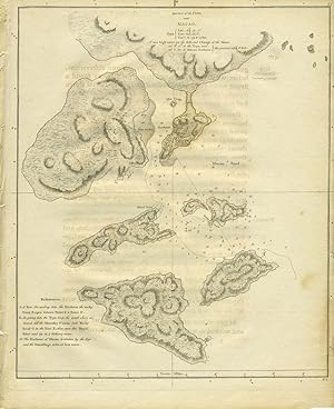
Sketch of the Typa, and Macao. Map
Published by London
Seller: Antipodean Books, Maps & Prints, ABAA, Garrison, NY, U.S.A.
Association Member: ABAA ANZAAB ESA ILAB
Seller rating 4 out of 5 stars
Condition: Very good condition. Copper engraved map of Macao, China and the islands in its vicinity. From the English edition of "Cook's Voyages". Within the plate is a note - "NB. The Harbour of Macao is drawn by the Eye and the Soundings taken at low water." Full impression marks from the plate visible, with small margins, the number 81 just outside the rule at the top right corner. Unfolded, 8 1/2 x 10 1/2". With some slight transfer from facing text.
-

Schets van Typa, of van Macao. Map
Published by Leiden, 1795
Seller: Antipodean Books, Maps & Prints, ABAA, Garrison, NY, U.S.A.
Association Member: ABAA ANZAAB ESA ILAB
Seller rating 4 out of 5 stars
Condition: Very good condition. A later hand colored copper engraved map of Macao, China and the islands in its vicinity. From a Dutch edition of "Cook's Voyages". On fine wove paper with full impression marks from the plate visible. Contemporary folds. 8 1/4 x 10 1/2", with margin slightly trimmed at lower left.
-

Pas-Kaart van het in en opkomen van de Rivier van Quantong aan de Zuid Kust van China strekkende van het eiland S. Joan, tot aan de Noorder Lemes, met alle tot hiertoe bekende ankerplaatzen, dieptens en droogtens.
Publication Date: 1753
Seller: Geographicus Rare Antique Maps, Brooklyn, NY, U.S.A.
Association Member: ABAA ESA ILAB
Seller rating 4 out of 5 stars
Map
Very good. Very minor dampstaining to margins. Slight foxing. Old color. Size 21 x 24 Inches. The rare 1753 Johannes II van Keulen / Jan de Marre nautical map of the Pearl River Delta (??????), including Macau (Macao), Lantao (Lantoan), Guangzhou (Quantong), and the first printed mapping of Hong Kong (Lantaon Falso). This rare map in fine original color was compiled for the sixth volume of the Zee-Fakkel - the legendary Dutch East India Company (VOC / Vereenigde Oostindische Compagnie ) 'Secret Atlas.' Lantao Falso - Hong Kong This is likely the earliest printed western map to depict Hong Kong in any form. Here it is labeled 'Lantaon Falso', terminology borrowed from the Portuguese meaning 'False Lantao'. At the time, it was unclear to cartographers and navigators that both Lantao (Lantaon) and Lantaon Falso were islands, and so both are here mapped as part of the mainland. In the early to mid-18th century, the Qing maintained a fort and single station on Lantao. This was Fan Lau Fort (????)built in 1729 at a high point on the southwestern extension of Lantau. It was both a critical defensive position and a beacon telling mariners to turn north towards Guangzhou (Canton), the only place in China Europeans were then permitted to trade. Sailing from the east, from trading entrepôts in Japan and the Philippines, navigators would first note the Victoria Peak, which some mistook for the equally mountainous Lantao, hence the name 'Lantaon Falso'. Deciphering the Map Other points can be recognized. To decipher this map, we have partially turned to a chart of 1780, the earliest British chart of these waters, which is in part derived from the present map. Mirs Bay (Mers Baay) is recognizable in the upper right. A partially mapped inlet 'R. Povado' (Iron River) is modern day Hebe Harbor. The two large islands to the west of Lantaon Falso are Lamma Island. Shenzhen is identified as Sinningham-hien, while the river entrance just south is likely Shenzhen Bay or even Tai La Kok. Still further north in the delta we can recognize a host of fortifications defending Guangzhou and the Pearl River estuary against the ever-present threat of piracy. Guangzhou, here identified as Quantong, is beautifully rendered in profile with multiple Chinese multi-tier pagoda towers and other buildings. Macau Macau appears at center, stressing its significance. Macao was a Portuguese colony established at the mouth of the Pearl River in 1557, when the Qing granted a permission for a permeant settlement. For centuries it served as the epicenter of European trade and culture in China. Here it is represented in insular form, with a series of fortifications defending access. Lampacau This is one of the few contemporaneous sources for the Island of Lampacau (???). This small island to the west of modern-day Macao was critical to the Sino-Portuguese trade in the 16th century. In subsequent centuries, silting in the Pearl River Delta has resulted in the island merging with its neighbors into a larger island and its historic location being lost. Lampacau became important for the China trade c.?1550, when the center of the Portuguese offshore trade in the Pearl River Delta gradually shifted there from the more remote Shangchuan (Sang-Tsaon, St. John's Island). Lampacau's significance dwindled after 1560, when trade recentered on the newly established colony of Macao. The Secret Atlas Much has been made of the so-called VOC 'Secret Atlas'. In 1753, Johannes II van Keulen (1704 - 1755) produced a revolutionary expansion of his grandfather's Zee-Fakkel . Published as Volume VI, the atlas was the first van Keulen publication to focus on Asian waters. For three generations the Van Keulen's were the official cartographers of the VOC. To protect their long-standing trade monopoly, the VOC jealously guarded hydrographic data on East Asian waters, refusing to allow charts to be printed and requiring oaths of secrecy from the Van Keulens (and Blaeus before them). By 1753, already.
-

A Plan of the City and Harbour of Macao A Colony of the Portugueze situated at the southern extremity of the Chinese Empire in Lat. 22 ?12?44'' N., long. 113?35?0'' east of Greenwich.
Publication Date: 1796
Seller: Geographicus Rare Antique Maps, Brooklyn, NY, U.S.A.
Association Member: ABAA ESA ILAB
Seller rating 4 out of 5 stars
Map
Very good. Wide clean margins. Size 31.5 x 22.25 Inches. A stunning large-format 1796 nautical chart and city map of Macao, its harbor, and the surrounding seas. This map was drawn by Benjamin Baker based on observations collected by the George Macartney Embassy - the first British embassy to China. The map is impressively proportioned and finely engraved, offering meticulous detail of Portugal's primary entrepôt in China. This map is considered the largest and finest 18th-century map of Macao obtainable. The Failed Embassy George Macartney was dispatched to Beijing in 1792 with a mission from King George III to convince the Chinese Emperor Qianlong to ease restrictions on trade between Great Britain and China, and to allow the British to have a permanent embassy. The well-equipped and impressive embassy traveled via Madeira, Tenerife, Rio de Janeiro, the Cape of Good Hope, Indonesia, and Macau. Macartney was accompanied by George Leonard Staunton (1737 - 1801) who served as the expedition's secretary and chronicler, and Staunton's 11-year-old son, nominally the ambassador's page, but also the only person in the retinue able to speak Mandarin. The Embassy was poorly managed from the beginning and despite considerable pomp from the English perspective, appeared poor and rag-tag to the Qianlong Emperor. Partly through lack of preparation, partly through arrogance, and partly due to the Emperor's distaste for the British, the Embassy failed in all of its primary objectives. They did accomplish some reconnaissance bringing to England some of the earliest first-hand accounts of the distant empire. While much has been made of Macartney's refusal to kowtow to the emperor, the failure of the mission might equally be laid to the Chinese Emperor's insistence - in a subsequent letter to King George III - in referring to all Europeans as 'barbarians', all nations of the earth as being subordinate to China, and addressing the king himself as a Chinese subject, abjuring him to 'Tremblingly obey and show no negligence!' Macao Macao, or Macau, is a former colony of the Portuguese Empire established in 1557 as a trade entrepôt with Ming China. Macau reached its peak of prosperity in the late 16th and early 17th centuries, transforming from a small trading center into a major city. When the Qing conquered China in 1644, foreign maritime trade was banned, leaving Macao as the only access point for foreign trade into China. Later, regulations were loosened, and the Canton system was reinstated, but all foreign ships were required to stop at Macau before proceeding to Guangzhou / Canton. Following the First Opium War (1839 - 1842) and the establishment of Hong Kong (1841) as a British Crown Colony, Macau lost its role as a major port and entered into a long period of decline. Portugal paid an annual rent and administered the territory under Chinese sovereignty until 1887, when it gained perpetual colonial rights in the Sino-Portuguese Treaty of Peking. The colony remained under Portuguese rule until 1999, when it was transferred to China. Today, like nearby Hong Kong, Macau is considered a special administrative region of the People's Republic of China. Publication History and Census The map was drawn by Benjamin Baker and published by George Nicol to illustrate George Leonard Staunton's An authentic account of an embassy from the King of Great Britain to the Emperor of China . The map is rare to the market, but well represented institutionally. References: OCLC 213892451. Library of Congress, G7823.M2 1796 .B2 TIL.
-

Condition: New. Dieser Artikel ist ein Print on Demand Artikel und wird nach Ihrer Bestellung fuer Sie gedruckt. Mark Feng Teng is a language teacher educator in China and a research fellow at University of Macau. He is an active researcher in the applied linguistics/TESOL community. He has extensive teaching and teacher education experience in mai.
-

Teilansicht, Tempel - Fassade des großen Tempels in Macao, "Vues de la Chine".
Language: German
Seller: Antiquariat Clemens Paulusch GmbH, Berlin, Germany
Seller rating 5 out of 5 stars
Art / Print / Poster
Stahlstich n. Thomas Allom aus China in a series views, 1843, 5,5 x 9,1 Verkleinerter Stahlstich auf ein typographisch vorbereitetes, blaues Untersatzpapier mit goldgeprägter Ornamentik montiert. Blattgröße 10,1 x 13,8 cm. - Kleiner schwarzer Fleck unten rechts, sonst sauber und sehr gut erhalten.
-

Kupferstich- Karte, n. Bellin, "Karte von Eylanden in der Mundung des Flusses Canton".
Language: German
Seller: Antiquariat Clemens Paulusch GmbH, Berlin, Germany
Seller rating 5 out of 5 stars
Map
um 1750, 19 x 31 Zeigt den Küstenbereich mit den vorgelagerten Inseln von der Mündung des Kantonflusses bis zur Insel Chang-chuen-chan ( Shangchwanshan ). Mit Einzeichnung von Macao.
-

Kupferstich- Karte, n. Bellin, "Carte des Isles qui sont a L'Embouchure de la Riviere de Canton".
Language: German
Seller: Antiquariat Clemens Paulusch GmbH, Berlin, Germany
Seller rating 5 out of 5 stars
Map
1748, 20,7 x 32 Zeigt den Küstenbereich mit den vorgelagerten Inseln von der Mündung des Kantonflusses bis zur Insel Chang-chuen-chan ( Shangchwanshan ). Mit Einzeichnung von Macao.
-

Kupferstich- Karte n. Bellin, "Karte von der Einfahrt des Flusses Canton nach den neuesten Wahrnehmungen entworfen".
Language: German
Seller: Antiquariat Clemens Paulusch GmbH, Berlin, Germany
Seller rating 5 out of 5 stars
Map
1749, 25,5 x 20,5 (H) Obe rechts die Kartusche. Zeigt unten mittig die Insel Macao.
-

Kupferstich- Karte, aus Weltbott v. G.C. Dietell, "Land-Taffel der Insel Sanciano".
Language: German
Seller: Antiquariat Clemens Paulusch GmbH, Berlin, Germany
Seller rating 5 out of 5 stars
Map
1729, 21 x 20,5 (H) Seltene Karte - Die Karte stammt aus:"Der neue Welt-Bote", dem bedeutenden Werk mit Quellen zur Missionsgeschichte des 18. Jahrh. ( hrsg. v. J. Stöcklein ). - Die Karte zeigt die Umgebung von Macao. Über der Karte eine schematische Darstellung der Grabstätte des Heiligen Franc. Xaverry auf der Insel Sancianao.
-

Teilansicht, Uferansicht, "Macao. Opfertempel" (A-Ma Temple).
Language: German
Seller: Antiquariat Clemens Paulusch GmbH, Berlin, Germany
Seller rating 5 out of 5 stars
Art / Print / Poster
Chromolitho. v. W. Loeillot n. Hildebrandt b. Mitscher, um 1880, 25,8 x 38 Die Chromolithografien wurden von R. Steinbock und W. Loeillot nach den von Eduard Hildebrandt meist auf seiner Weltreise 1862/63 geschaffenen Aquarellen angefertigt. - Original auf einen Untersatzkarton montiert ( 56 x 45,5 cm ). Verso mit Verlagsschild " No. 28 Ed. Hildebrandt . - Die Reise um die Erde ". Lit.: s. Th./B.XVII. Tadellos sauber, dekoratives Blatt. Rechts unten in der Darstellung: E. Hildebrandt.
-

Teilansicht, "Macao - Theater Sing Song".
Language: German
Seller: Antiquariat Clemens Paulusch GmbH, Berlin, Germany
Seller rating 5 out of 5 stars
Art / Print / Poster
Chromolitho. v. R. Steinbock n. Hildebrandt b. Mitscher, um 1880, 23,7 x 37,4 Die Chromolithografien wurden von R. Steinbock und W. Loeillot nach den von Eduard Hildebrandt meist auf seiner Weltreise 1862/63 geschaffenen Aquarellen angefertigt. - Original auf einen Untersatzkarton montiert ( 56 x 45,5 cm ). Verso mit Verlagsschild " No. 17 Ed. Hildebrandt . - Die Reise um die Erde ". Lit.: s. Th./B.XVII. Tadellos sauber, dekoratives Blatt. Rechts unten in der Darstellung: E. Hildebrandt.
-

Condition: New. Dieser Artikel ist ein Print on Demand Artikel und wird nach Ihrer Bestellung fuer Sie gedruckt. Mark Feng Teng is a language teacher educator in China and a research fellow at University of Macau. He is an active researcher in the applied linguistics/TESOL community. He has extensive teaching and teacher education experience in mai.


