Christopher Cellarius (16 results)

Language: English
Published by Joannis Owen, Cambridge UK, 1703
- Hardcover
Seller: Hirschfeld Galleries, Saint Louis, MO, U.S.A.Hirschfeld Galleries
Contact seller2-star sellerCondition: Used - Good
US$ 900.00
US$ 8.50 shippingShips within U.S.A.Quantity: 1 available
Hardcover. Condition: Good. 2nd Edition. Stout 4to. 2nd edition after the 1701 21 copper engraved maps black and white as issued, with the Sotheby book plate, armorial and engraved. book disbound, with original back and boards loose needs re binding or for the maps, which are crisp. and clean. Cellarius (illustrator).
 More images
Published by F. C. and J. Rivington. London, 1821
- Hardcover
- Map
Seller: Addyman Books, Hay-on-Wye, United KingdomAddyman Books
Contact seller5-star sellerCondition: Used
US$ 687.33
US$ 32.03 shippingShips from United Kingdom to U.S.A.Quantity: 1 available
A New Edition. Printed with a lovely clear double page title, contents page also a double page spread and 33 double page maps, sculpted by R. W. Seale. Original marbled boards, rubbed but sound, rebacked in modern plain brown calf, old tape marks to boards and endpapers. A lovely flowing ownership signature, dated 1822 with a ve…ry sweet pencil drawing of two pigs also to front free endpaper and some very professional owls to rear endpapers. A few portions of foxing to prelims and margins but the maps are clean. A lovely early 19th century atlas.
Published by Dublin: Geographia Antiqua, [c.1794], 1794
Seller: Peter Harrington. ABA/ ILAB., London, United KingdomPeter Harrington. ABA/ ILAB.
Contact seller5-star sellerCondition: Used
US$ 96.23
US$ 29.36 shippingShips from United Kingdom to U.S.A.Quantity: 1 available
An attractive map of Roman France, with a decorative cartouche representing a Roman General handling a crown to a female figure, perhaps Gallia, and a cock representing Gallic pride. Copper engraving. Hand coloured. Sheet size: 245 x 332 mm Plate size: 210 x 310 mm Very good condition.
 More images
Language: Latin
Published by Joannis Oweni, Cantabrigiae [Cambridge], 1703
- Hardcover
Seller: ecbooks, Orkney Islands, United Kingdomecbooks
Contact seller5-star sellerCondition: Used - Very good
US$ 1,649.60
US$ 33.37 shippingShips from United Kingdom to U.S.A.Quantity: 1 available
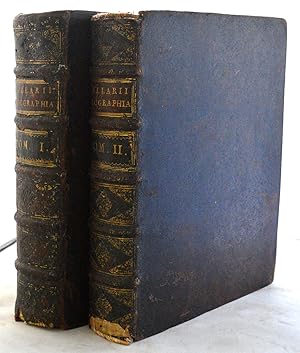
Full-Leather. Condition: Very Good. A very good early copy of this atlas of the ancient world which was first published in Leipzig in 1701. In 2 volumes with contemporary full leather bindings; frontispiece portrait of Cellarius; 33 folding maps; one folding diagram; and decorative initial capitals, head and tailpieces. Vol I: b…lank; frontispiece; title page 1703 in red and black with vignette; dedication 5pp; Preface 4pp; Contents listing 1p; Text with initial vignette, 20 folding maps and one folding diagram pp 1-862 with errata list on final page; index 38pp. Vol II: blank; title page 1706 in red and black with vignette; dedication 5pp; 'Benevolo Lectori' 3pp; Contents 2pp; Text (Asia) p 1-544; half title Africa; text pp 3-266; 13 maps (distributed through the book); index 38pp; blank. Both bindings are sound and have raised bands, gilt tooling to the spines and title and volume labels. They have wear - particularly to the base of the spine and corners, and some rubbing to joints. Vol I is particularly bright and clean internally. There is a small repaired margin tear to p5/6. Vol II has brown toning to the paper and occasional small staining mostly to the top outer page corners.There is a little creasing at p 3-5. All the maps in both volumes are in very good complete clean condition.
Published by Dublin: Geographia Antiqua, [c.1794], 1794
Seller: Peter Harrington. ABA/ ILAB., London, United KingdomPeter Harrington. ABA/ ILAB.
Contact seller5-star sellerCondition: Used
US$ 103.10
US$ 29.36 shippingShips from United Kingdom to U.S.A.Quantity: 1 available
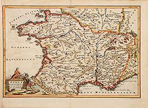
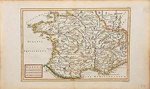
An attractive 18th century map of Roman France: Gaul, Narbonne, Lyon and Aquitaine. Copper engraving. Hand coloured. Sheet size: 262 x 370 mm Plate size: 215 x 315 mm Very good condition.
Published by Dublin: Geographia Antiqua, 1794, 1794
Seller: Peter Harrington. ABA/ ILAB., London, United KingdomPeter Harrington. ABA/ ILAB.
Contact seller5-star sellerCondition: Used
US$ 103.10
US$ 29.36 shippingShips from United Kingdom to U.S.A.Quantity: 1 available
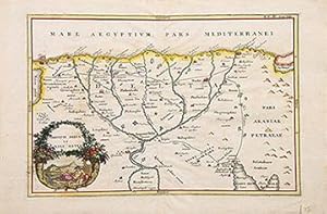
An attractive map of the mouth and estuary of the Nile in Egypt, together with a cartouche of a double cornucopia showing the anthropomorphic figure of the River Nile and the Sphinx of Giza. Copper engraving. Hand coloured. Sheet size: 232 x 356 mm Plate size: 206 x 312 mm Very good condition.
Published by Dublin: Geographia Antiqua, [c.1794], 1794
Seller: Peter Harrington. ABA/ ILAB., London, United KingdomPeter Harrington. ABA/ ILAB.
Contact seller5-star sellerCondition: Used
US$ 116.85
US$ 29.36 shippingShips from United Kingdom to U.S.A.Quantity: 1 available
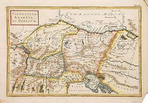
An attractive map of the ancient Roman provinces North of Italy and current Austria and Slovenia. Copper engraving. Hand coloured. Size: 235 x 344 mm Very good condition.
Published by Dublin: Geographia Antiqua, 1794, 1794
Seller: Peter Harrington. ABA/ ILAB., London, United KingdomPeter Harrington. ABA/ ILAB.
Contact seller5-star sellerCondition: Used
US$ 116.85
US$ 29.36 shippingShips from United Kingdom to U.S.A.Quantity: 1 available
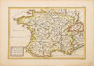
An attractive map of Roman France. Copper engraving. Hand coloured. Sheet size: 232 x 372 mm Plate size: 216 x 315 mm Very good condition.
Published by Dublin: Geographia Antiqua, [c.1794], 1794
Seller: Peter Harrington. ABA/ ILAB., London, United KingdomPeter Harrington. ABA/ ILAB.
Contact seller5-star sellerCondition: Used
US$ 130.59
US$ 29.36 shippingShips from United Kingdom to U.S.A.Quantity: 1 available
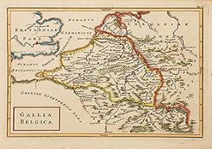
A map of ancient Roman Belgium. Copper engraving. Hand coloured. Size: 235 x 326 mm Very good condition.
Published by Dublin: Geographia Antiqua, 1794, 1794
Seller: Peter Harrington. ABA/ ILAB., London, United KingdomPeter Harrington. ABA/ ILAB.
Contact seller5-star sellerCondition: Used
US$ 130.59
US$ 29.36 shippingShips from United Kingdom to U.S.A.Quantity: 1 available
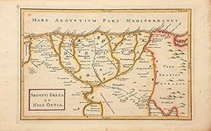
An attractive map of the Delta of River Nile and the Northern part of Egypt. Copper engraving. Hand coloured. Sheet size: 234 x 375 mm Plate size: 208 x 315 mm Very good condition.
Published by Geographia Antiqua, 1794, 1794
Seller: Peter Harrington. ABA/ ILAB., London, United KingdomPeter Harrington. ABA/ ILAB.
Contact seller5-star sellerCondition: Used
US$ 130.59
US$ 29.36 shippingShips from United Kingdom to U.S.A.Quantity: 1 available
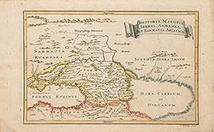
An attractive map of the Caucasus with the Black and Caspian seas. Copper engraving. Hand coloured. Size: 232 x 374 mm Very good condition.
Published by Geographia Antiqua, 1794, 1794
Seller: Peter Harrington. ABA/ ILAB., London, United KingdomPeter Harrington. ABA/ ILAB.
Contact seller5-star sellerCondition: Used
US$ 164.96
US$ 29.36 shippingShips from United Kingdom to U.S.A.Quantity: 1 available
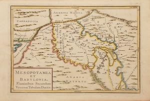
Copper engraving. Hand coloured. Size: 233 x 350 mm Very good condition.
Published by Dublin: Geographia Antiqua, [c.1794], 1794
Seller: Peter Harrington. ABA/ ILAB., London, United KingdomPeter Harrington. ABA/ ILAB.
Contact seller5-star sellerCondition: Used
US$ 164.96
US$ 29.36 shippingShips from United Kingdom to U.S.A.Quantity: 1 available
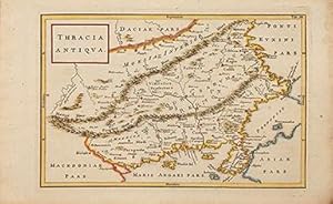
An attractive map of Ancient Thracia. Copper engraving. Hand coloured. Sheet size: 234 x 372 mm Plate size: 218 x 312 mm Very good condition.
Published by Dublin: Geographia Antiqua, 1794, 1794
Seller: Peter Harrington. ABA/ ILAB., London, United KingdomPeter Harrington. ABA/ ILAB.
Contact seller5-star sellerCondition: Used
US$ 164.96
US$ 29.36 shippingShips from United Kingdom to U.S.A.Quantity: 1 available
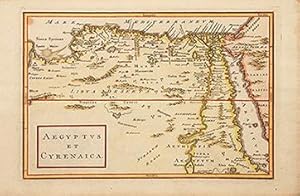
An attractive map of Egypt and the Cyrenaic Peninsula and Egypt. Copper engraving. Hand coloured. Sheet size: 232 x 356 mm Plate size: 206 x 312 mm Very good condition.
Published by Dublin: Geographia Antiqua, [c.1794], 1794
Seller: Peter Harrington. ABA/ ILAB., London, United KingdomPeter Harrington. ABA/ ILAB.
Contact seller5-star sellerCondition: Used
US$ 226.82
US$ 29.36 shippingShips from United Kingdom to U.S.A.Quantity: 1 available
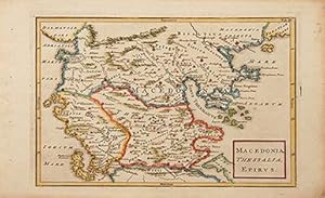
An attractive map of the Ancient Northern part of Greece. Copper engraving. Hand coloured. Size: 235 x 375 mm Very good condition.

Seller: Antiquariat Librissimo, Eicklingen, GermanyAntiquariat Librissimo
Contact seller5-star sellerCondition: Used
US$ 117.43
US$ 51.31 shippingShips from Germany to U.S.A.Quantity: 1 available
Felix Bielcke, Jena, 1730. 8 Bl., 242 S., 3, 2 Bl., 275 S., 3, 4 Bl., 550 (statt 575) Seiten mit Holzschnitt-Druckermarke. Pergament der Zeit (Einband fleckig/ Kapital mit kleinem Ausbruch/ es fehlt S. 1-2 des ersten Teils/ S. 223 mit großem Ausriss und Textverlust)---- Enthält auch: Teil 2: Historia media aevi temporibus consta…ntini magni ad constantinopolim a turcis captam deducta/ Teil 3: Historia nova hoc est XVI et XVII saeculorum cum initio seculi XVIII. NDB 3, S. 180; vgl. VD18 14149680 (Ausgabe 1732). -.


