
Order Total (1 Item Items):
Shipping Destination:

Debuissons (4 results)
Skip to main search results
Search filters
Product Type
- All Product Types
- Books (2)
- Magazines & Periodicals (No further results match this refinement)
- Comics (No further results match this refinement)
- Sheet Music (No further results match this refinement)
- Art, Prints & Posters (No further results match this refinement)
- Photographs (No further results match this refinement)
- Maps (2)
- Manuscripts & Paper Collectibles (No further results match this refinement)
Condition Learn more
- New (No further results match this refinement)
- As New, Fine or Near Fine (2)
- Very Good or Good (No further results match this refinement)
- Fair or Poor (No further results match this refinement)
- As Described (2)
Binding
Collectible Attributes
- First Edition (No further results match this refinement)
- Signed (No further results match this refinement)
- Dust Jacket (No further results match this refinement)
- Seller-Supplied Images (4)
- Not Print on Demand (4)
Language (2)
Price
- Any Price
- Under US$ 25 (No further results match this refinement)
- US$ 25 to US$ 50 (No further results match this refinement)
- Over US$ 50
Free Shipping
- Free Shipping to U.S.A. (No further results match this refinement)
Seller Location
Seller Rating
-
Couverture rigide. Condition: Bon. Historique scientifique industriel et commercial. 43 cartes en couleurs � double page. Textes explicatifs et cartes mont�s sur onglets. Frottements � la reliure, coins �mouss�s. Int�rieur tr�s frais. Bon �tat. R�f 23254. In-folio (29x37 cm) reliure �diteur demi-chagrin noir, dos orn�, plats percaline estamp�s orn�s de motifs dor�s.
-

Carte D'ASIE / Dress�e par E. Debuissons, sous lam direction de E. Cortambert; Grav�e par Th. Gobert; Ecrite et colori�e par Beaurain
Published by Publi� par Boulanger & Legrand, 1864
Seller: Librer�a Miguel Miranda, Lope de Vega n.� XIX, Madrid, M, Spain
Seller rating 5 out of 5 stars

Map
Condition: Good / Bien. Paris: Publi� par Boulanger & Legrand (Directeurs de l'Echo des Feuilletons), 1864.- Mapa grabado de 47,5 x 59 cm. plegado, con contornos en varios colores; Texto en franc�s.- RARO. Restaurado de peque�os desgarros en los bordes. Por lo dem�s en muy buen estado. Livre en fran�ais GEOGRAF�A, GU�AS Y ATLAS DEL EXTRANJERO.
-
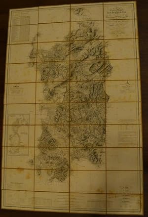
Carta dell'Isola e Regno di Sardegna
Published by Gio-Batta Maggi,, Torino,, 1845
Seller: Studio Bibliografico Benacense, Riva del garda, TN, Italy
Seller rating 5 out of 5 stars
Grande carta geografica incisa in rame, applicata su tela e pi� voltre ripiegate di cm. 100 x 160 ca. Entro custodia originale in cartoncino marmorizzato con titoli a stampa. Qualche arrossatura, ma complessivamente buono stato di conservazione. Celebre e dettagliata carta dell'isola di Sardegna dedicata dal La Marmora alla Maest� del Re Carlo Alberto Primo. Non comune.
-

Oceanie
Language: French
Publication Date: 1882
Seller: Anah Dunsheath RareBooks ABA ANZAAB ILAB, Auckland, NZ, New Zealand
Association Member: ABA ANZAAB ILAB
Seller rating 5 out of 5 stars
Map
No Binding. Condition: Near Fine. Lacoste, C H (illustrator). Coloured map of the Pacific with details of the Philippines, Indonesia, Australia, New Zealand and the Pacific Islands. With an inset detailed map of Australia, and a b&w vignette of Polynesian figures with canoes. 29 x 31 cm in mount 50 x 44 cm.
