Order Total (1 Item Items):
Shipping Destination:

Denham Capt (10 results)
Skip to main search results
Search filters
Product Type
- All Product Types
- Books (9)
- Magazines & Periodicals (No further results match this refinement)
- Comics (No further results match this refinement)
- Sheet Music (No further results match this refinement)
- Art, Prints & Posters (No further results match this refinement)
- Photographs (No further results match this refinement)
- Maps (1)
- Manuscripts & Paper Collectibles (No further results match this refinement)
Condition Learn more
- New (1)
- As New, Fine or Near Fine (1)
- Very Good or Good (3)
- Fair or Poor (No further results match this refinement)
- As Described (5)
Binding
Collectible Attributes
- First Edition (3)
- Signed (No further results match this refinement)
- Dust Jacket (No further results match this refinement)
- Seller-Supplied Images (8)
- Not Print on Demand (9)
Language (3)
Price
- Any Price
- Under US$ 25 (No further results match this refinement)
- US$ 25 to US$ 50
- Over US$ 50
Free Shipping
- Free Shipping to U.S.A. (No further results match this refinement)
Seller Location
Seller Rating
-

Travels and Discoveries in Northern and Central Africa,, in 1822, 1823, and 1824 [Volume IV Only]
Published by London: John Murray, 1831
Hardcover. Condition: Good. Hardcover. Half bound in leather and green cloth. Gilt stamping on black title label over spine. Bottom half of spine is lifting and revealing binding beneath. Covers are rubbed, but there are no significant markings. Binding is square and strong. Illustrated frontispiece of Captain Hugh Clapperton. Title page is dated 1831 in roman numerals. 279 pages. Interiors are clean and unmarked. A good copy. Captain Hugh Clapperton was a Scottish naval officer and explorer of West and Central Africa. Major Dixon Denham was an English soldier, explorer of West Central Africa, and ultimately Governor of Sierra Leone. Denham and Clapperton were always at odds with one another.
-
No Binding. Condition: Very Good. Capt. Denham. Die Insel Tristan Da Cunha. 1852. This is an engraved lithograph with hand coloring published in Gotha, Germany by Justus Perthes in 1855. This volcanic island in the South Atlantic Ocean is one of the most isolated places on our planet inhabited by humans. The main map names topographic features and shows the island's only settlement - Ansiedlung. The lower left inset map is of the South Atlantic and orients Tristan Da Cunha in relation to other islands and two continents. The lower right inset map is a plan of Ansiedlung. Between the two inset maps is an elevation of the island as seen from a ship at sea (that is not bobbing up and down in 20 foot seas). This island is still an active volcano. *** Clear, clean image with good color, some spots of foxing at top, mostly in margin. Blank verso. No folds, tears, or creases. *** Sheet is approx. 10.5 inches high by 8.25 inches, image 9.75 inches high by 7.5 inches. #1719.
-
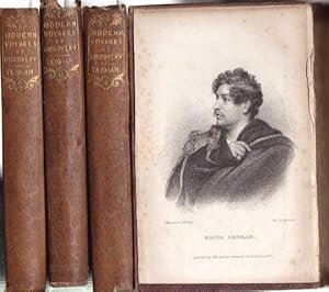
Travels and Discoveries in Northern and Central Africa in 1822, 1823, and 1824 (4 vols.)
Published by John Murray, London, 1831
Seller: Kevin T. Ransom- Bookseller, Amherst, NY, U.S.A.
Seller rating 4 out of 5 stars

First Edition
Hardcover. Condition: Good. 1st Edition. 16mo. Hardcover. 4 volumes. Bound in marbled paper-covered boards with white vellum spines & corner points. 1st edition. Illustrated in b&w. Covers edge-worn & spines dulled. Solid bindings. Interiors very good.
-
Travels and Discoveries on northern and central Africa in 1822, 1823 and 1824; by . Volume I (of IV).
Published by London. John Murray, Albemarle-Street. 1831., 1831
Hardcover. Condition: sehr gut. Leinenband der Zeit mit goldgepr�gtem R�ckentitel, 15 x 9,5 cm. 304, 257, 259, 279 Seiten, mit ausfaltbarer Karte und 5, 3, 2, 2 Kupfern (teils mit Seidenhemdchen). Die Seiten 193-208 (Bd. I) zwischen den Seiten 272 und 273 dingebunde, im Titel gebrochen, unruhiger Schnitt, die anderen B�nden etwas bestossen und berieben, teils wenig gebr�unt, so sehr gutes Ensemble. Inhalt: From Tripoli to Mourzuk, Excursion to Westward of Mourzuk, From Mourzuk to Kouka in Bornou, Kouka, Expedition to Mandara, Excursion to Munga and the Gambarou, Rainy Season at Kouka, Excursion to Loggarn and death of Mr. Toole, Journey to the Eastern Shores of the Lake Tchad and Return to Tripoli, Additional Notes on Bornou, Excursion from Kouka in Bornou to Murmur, wherd Dr. Oudney died, Excursion from Murmur to kano, Fraom Kano to Sackatoo , Return from Sackatoo, Captain Clappertons 2nd Expedition into Africa, and an Accout of his Death, from Richard Landers Journal in englischer Sprache.
-

West Coast of Africa, Sheet XV, Cape St. Paul to Porto Novo
Published by London, London, 1846
Seller: High Ridge Books, Inc. - ABAA, South Deerfield, MA, U.S.A.
Association Member: ABAA ESA ILAB SNEAB
Seller rating 5 out of 5 stars

Small linen-back chart of the southern coast of western Africa to Porto Novo, in modern Benin to Cape St. Paul in eastern Ghana. Very good condition, with light soiling and general wear. Uncolored. Several Slave Stations are identified along the coast, with a Slave Factory in the village of Wyee or Awey at Cape St. Paul. 15 coastal views. Published by the British Hydrographic Office from surveys taken by Captain Denham in H. M. S. Avon.
-

West Coast of Africa, Sheet XVI, Porto Novo to Jaboo
Published by London, London, 1846
Seller: High Ridge Books, Inc. - ABAA, South Deerfield, MA, U.S.A.
Association Member: ABAA ESA ILAB SNEAB
Seller rating 5 out of 5 stars
Small linen-back chart of the southern coast of western Africa from Porto Novo, in modern Benin, to Jaboo, east of Lagos in Nigeria. Good condition, with light soiling, four dark spots, and some water staining at right side. Uncolored. Identifies several Slave Stations along the coast. 7 coastal profiles. Published by the British Hydrographic Office from surveys taken by Captain Denham in H. M. S. Avon.
-
Narrative of Travels and Discoveries in Northern and Central Africa, in the Years 1822, 1823 and 1824, by Major Denham, Captain Clapperton and The Late Doctor Oudney, Extending Across the Desert to the Tenth Degree of North Latitude, and from Korika in Bornou, to Sackatoc, The Capital of The Fellatah Empire. With an Appendix
Published by John Murray, London, 1826
Seller: James Cummins Bookseller, ABAA, New York, NY, U.S.A.
Seller rating 5 out of 5 stars
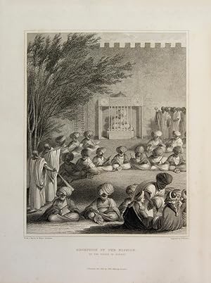
Second Edition. Second Edition. Engraved frontispiece and 40 engraved plates (one colored), after original drawings by Denham and Clapperton, engraved by Edward Finden. large folding map at end. lxxxviii, 321, 2pp; iv, 413pp. 2 vols. 4to. "An official expedition to discover the course of the Niger from the starting point of Tripoli, rather than West Africa. Denham and Clapperton (1786-1828) were part of the expedition led by the Scottish doctor Walter Oudney to open relations with the Fulani kingdom, whose legendary trading centre was Kano, in order to discover the source of the Niger, which was widely believed to flow into Lake Chad. Having crossed the Sahara and found no rivers entering Lake Chad, the party divided with Denham exploring the Shari River and Oudney and Clapperton (who shared a mutual loathing of Denham) proceeding to Kano. Oudney died en route but Clapperton was received by the ruler of Kano, Mohammed Bello who, having first supplied an accurate map of the course of the Niger, later backtracked and supplied another misleading map when he realised the dangers of opening up his kingdom to foreigners. Clapperton rejoined Denham at Lake Chad and back across the Sahara." Howgego D18 Vol. II; Gay 337; Ibrahim-Hilmy I, p172 Three quarters modern speckled brown calf, marbled boards, gilt tooled spine with red label, book plate of "Foster." Totally uncut Engraved frontispiece and 40 engraved plates (one colored), after original drawings by Denham and Clapperton, engraved by Edward Finden. large folding map at end. lxxxviii, 321, 2pp; iv, 413pp. 2 vols. 4to.
-
Narrative of Travels and Discoveries in Northern and Central Africa, in the Years 1822, 1823 and 1824, by Major Denham, Captain Clapperton and The Late Doctor Oudney, Extending Across the Desert to the Tenth Degree of North Latitude, and from Korika in Bornou, to Sackatoc, The Capital of The Fellatah Empire. With an Appendix
Published by John Murray, London, 1826
Seller: James Cummins Bookseller, ABAA, New York, NY, U.S.A.
Seller rating 5 out of 5 stars
First Edition
First edition. First edition. Engraved frontispiece and 40 engraved plates (one colored), after original drawings by Denham and Clapperton, engraved by Edward Finden. large folding map at end. xlviii, [270], 2 pp. 1 vols. 4to. "An official expedition to discover the course of the Niger from the starting point of Tripoli, rather than West Africa. Denham and Clapperton (1786-1828)were part of the expedition led by the Scottish doctor Walter Oudney to open relations with the Fulani kingdom, whose legendary trading centre was Kano, in order to discover the source of the Niger, which was widely believed to flow into Lake Chad. Having crossed the Sahara and found no rivers entering Lake Chad, the party divided with Denham exploring the Shari River and Oudney and Clapperton (who shared a mutual loathing of Denham) proceeding to Kano. Oudney died en route but Clapperton was received by the ruler of Kano, Mohammed Bello who, having first supplied an accurate map of the course of the Niger, later backtracked and supplied another misleading map when he realised the dangers of opening up his kingdom to foreigners. Clapperton rejoined Denham at Lake Chad and back across the Sahara." Howgego D18 Vol. II; Gay 337; Ibrahim-Hilmy I, p172 Contemporary half-calf, rebacked. Some offset to title from frontis, hinges reinforced, minor marginal staining in a few spots, but an excellent copy Engraved frontispiece and 40 engraved plates (one colored), after original drawings by Denham and Clapperton, engraved by Edward Finden. large folding map at end. xlviii, [270], 2 pp. 1 vols. 4to.
-
Narrative of travels and discoveries in northern and central Africa, in the years 1822, 1823, and 1824. extending across the great desert to the tenth degree of northern latitude, and from Kouka in Bornou, to Sackatoo, the capital of the Fellatah empire. With an Appendix.
Published by London Murray, 1826
Seller: Shapero Rare Books, London, United Kingdom
Association Member: ABA ILAB PBFA
Seller rating 5 out of 5 stars
First Edition
US$ 1,036.25
US$ 20.12 shipping
Ships from United Kingdom to U.S.A.Quantity: 1 available
Add to basketFirst edition, 4to, xlviii (i.e. lxviii), 335, [1](blank); [4], 138, [139]-269 (appendix), [1](printer's note), [2](list of plates)pp.; frontispiece and thirty-six engraved plates, plus one folding map, contemporary calf, modern reback, new endpapers, corners worn, a good clean copy. An official expedition to discover the course of the Niger from the starting point of Tripoli, rather than West Africa. Denham and Clapperton were part of the expedition led by the Scottish doctor Walter Oudney to open relations with the Fulani kingdom, whose legendary trading centre was Kano, in order to discover the source of the Niger, which was widely believed to flow into Lake Chad. Having crossed the Sahara and found no rivers entering Lake Chad, the party divided with Denham exploring the Shari River and Oudney and Clapperton (who shared a mutual loathing of Denham) proceeding to Kano. Oudney died en route but Clapperton was received by the ruler of Kano, Mohammed Bello who, having first supplied an accurate map of the course of the Niger, later backtracked and supplied another misleading map when he realised the dangers of opening up his kingdom to foreigners. Clapperton rejoined Denham at Lake Chad and back across the Sahara. Gay 337; cf. Playfair (Tripoli), 154 (3rd ed).
-

Condition: New. Dieser Artikel ist ein Print on Demand Artikel und wird nach Ihrer Bestellung fuer Sie gedruckt. KlappentextrnrnTrieste Publishing has a massive catalogue of classic book titles. Our aim is to provide readers with the highest quality reproductions of fiction and non-fiction literature that has stood the test of time. The many thousands of b.