
Dower John Engraved by Dower John (6 results)

Published by London. 1835, 1835
Seller: Peter Harrington. ABA/ ILAB., London, United KingdomPeter Harrington. ABA/ ILAB.
Contact seller5-star sellerCondition: Used
US$ 103.47
US$ 29.47 shippingShips from United Kingdom to U.S.A.Quantity: 1 available
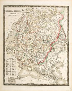
This map is from A New General Atlas of the World published by Henry Teesdale & Co. With coloured margins of each state. It shows cities, place names, roads, rivers, lakes, and islands Copper engraving. Very good condition. Original colour. Size: 35 x 43 cm.

Published by A New General Atlas of the World,. Henry Teesdale & co. 302, High Holborn,. March 1835., 1835
Seller: Peter Harrington. ABA/ ILAB., London, United KingdomPeter Harrington. ABA/ ILAB.
Contact seller5-star sellerCondition: Used
US$ 165.55
US$ 29.47 shippingShips from United Kingdom to U.S.A.Quantity: 1 available
Full title - A new General Atlas of the World, Compiled from the latest authorities both English and Foreign, Containing separate Maps of its various Countries & States, and exhibiting their boundaries & Divisions, also the Chains of Mountains, Rivers, Lakes and other Goegraphical Features, Comprehended in Forty Six Maps, Includ…ing Ancient Maps of Greece, the Roman and Persian Empires & Palestine, from Drawings made Expressly for this work, By John Dower. Paper watermarked J. Whatman 1834. With coloured margins of countries. Shows cities, place names, roads, rivers, lakes, and islands Copper engraving. Very good condition. Original colour. Size: 35 x 43 cm. (14 x 17 inches).

Published by London. 1835, 1835
Seller: Peter Harrington. ABA/ ILAB., London, United KingdomPeter Harrington. ABA/ ILAB.
Contact seller5-star sellerCondition: Used
US$ 241.43
US$ 29.47 shippingShips from United Kingdom to U.S.A.Quantity: 1 available
An accurate and up to date map of Canada. Published in A New General Atlas of the World by Henry Teesdale & Co. With coloured margins of countries. Shows cities, place names, roads, rivers, lakes, and islands. Copper engraving. Very good condition. Original colour. Size: 35 x 43 cm.
Published by A New General Atlas of the World,. Henry Teesdale & co. 302, High Holborn,. March 1835., 1835
Seller: Peter Harrington. ABA/ ILAB., London, United KingdomPeter Harrington. ABA/ ILAB.
Contact seller5-star sellerCondition: Used
US$ 241.43
US$ 29.47 shippingShips from United Kingdom to U.S.A.Quantity: 1 available
Full title - A new General Atlas of the World, Compiled from the latest authorities both English and Foreign, Containing separate Maps of its various Countries & States, and exhibiting their boundaries & Divisions, also the Chains of Mountains, Rivers, Lakes and other Goegraphical Features, Comprehended in Forty Six Maps, Includ…ing Ancient Maps of Greece, the Roman and Persian Empires & Palestine, from Drawings made Expressly for this work, By John Dower. Paper watermarked J. Whatman 1834. With coloured margins of countries. Shows cities, place names, roads, rivers, lakes, and islands Copper engraving. Very good condition. Original colour. Size: 35 x 43 cm. (14 x 17 inches).

Published by A New General Atlas of the World,. Henry Teesdale & co. 302, High Holborn,. March 1835., 1835
Seller: Peter Harrington. ABA/ ILAB., London, United KingdomPeter Harrington. ABA/ ILAB.
Contact seller5-star sellerCondition: Used
US$ 269.02
US$ 29.47 shippingShips from United Kingdom to U.S.A.Quantity: 1 available
Full title - A new General Atlas of the World, Compiled from the latest authorities both English and Foreign, Containing separate Maps of its various Countries & States, and exhibiting their boundaries & Divisions, also the Chains of Mountains, Rivers, Lakes and other Goegraphical Features, Comprehended in Forty Six Maps, Includ…ing Ancient Maps of Greece, the Roman and Persian Empires & Palestine, from Drawings made Expressly for this work, By John Dower. Paper watermarked J. Whatman 1834. With coloured margins of countries. Shows cities, place names, roads, rivers, lakes, and islands Copper engraving. Very good condition. Original colour. Size: 35 x 43 cm. (14 x 17 inches).
Published by London. 1858-63, 1858
Seller: Peter Harrington. ABA/ ILAB., London, United KingdomPeter Harrington. ABA/ ILAB.
Contact seller5-star sellerCondition: Used
US$ 413.88
US$ 29.47 shippingShips from United Kingdom to U.S.A.Quantity: 1 available
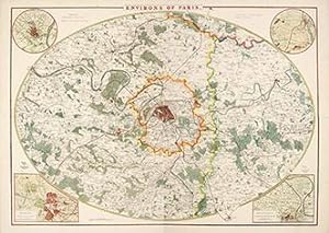
An attractive large oval map of the area around Paris. Four inset maps, one in each corner Versailles, St. Germain en Laye, St. Cloud and Fontainebleu. Title at top centre. Published in The Dispatch Atlas. Weekly Dispatch. Lithograph. Good margins. Fine condition. Later colour. Size: 600 mm x 840 mm. Two sheets joined together.


