
Order Total (1 Item Items):
Shipping Destination:

Dutton Capt Clarence (23 results)
Skip to main search results
Search filters
Product Type
- All Product Types
- Books (5)
- Magazines & Periodicals (No further results match this refinement)
- Comics (No further results match this refinement)
- Sheet Music (No further results match this refinement)
- Art, Prints & Posters (7)
- Photographs (No further results match this refinement)
- Maps (11)
- Manuscripts & Paper Collectibles (No further results match this refinement)
Condition Learn more
- New (No further results match this refinement)
- As New, Fine or Near Fine (No further results match this refinement)
- Very Good or Good (3)
- Fair or Poor (No further results match this refinement)
- As Described (20)
Binding
Collectible Attributes
- First Edition (1)
- Signed (No further results match this refinement)
- Dust Jacket (No further results match this refinement)
- Seller-Supplied Images (21)
- Not Print on Demand (23)
Language (2)
Price
- Any Price
- Under US$ 25 (No further results match this refinement)
- US$ 25 to US$ 50
- Over US$ 50
Free Shipping
Seller Location
Seller Rating
-

Hawaiian Volcanoes
Language: English
Published by Smithsonian, Washington, 1984
Seller: Alexander Books (ABAC/ILAB), Ancaster, ON, Canada
Seller rating 5 out of 5 stars

First Edition
Hardcover. Condition: Good. 1st Edition. 144 Pages Illus. Maps, Fold Outs. Usual Ex-Lib Marks O/W Sound.
-
Soft cover. Condition: Good. No Jacket. 1979 reprint of the original document from 1890. United States Department of Interior, Cecil Andrus; Geological Survery, H. William Menard. Softcover. Condition is VG-. Cover corners are bumped, causing a slight warp to corners of text block. Cover ink rubbed off in spots, especially edges and corners; crease lines, small damp stain and rubbing on spine; cover toned around edges. Some small blemishes and speckling on top/bottom of text block. Pages lightly toned around edges. Pages appear clean and clear of writing, markings, highlighting or notable damage. Binding tight.
-
Atlas to Accompany the Monograph on the Tertiary History of the Grand Canyon District
Published by Department of the Interior, 1882
Seller: Arader Galleries - AraderNYC, New York, NY, U.S.A.
Seller rating 5 out of 5 stars
Hardcover. Condition: Very Good. Washington: Department of the Interior, 1882. Folio (20 x 17 3/4 inches, 505mm x 450mm). Lithographed title page with 10 double-page colour tinted lithographed views of the Grand Canyon, including one after Thomas Moran, based on a sketch by Holmes, and 9 after William H.Holmes plates, 11 double-page colour printed lithographed maps, and 1 uncoloured map. Bound in original publisher's brown cloth with gilt stamped title to the front board. On the spine, library label 746 to foot. Head and foot of spine worn. Cover worn. Some shading to edges around maps. Rich tones and bright colors. Bookplate of James Strohm Copley, and label of Santa Cruz City Free Library. Library stamps throughout on back of prints.Moran's famous painting"The Grand Ca�on of the Yellowstone" (1872) was the first landscape the government hung in the Capitol. It was purchased in June 1872, just three months after Congress voted to establish the Yellowstone area as the country's first national park. By 1873 Moran was in demand as an exploration artist. His work had been widely published, and The Grand Ca�on of the Yellowstone had been favorably reviewed in newspapers and journals. Capt. Clarence Dutton (1841-1912 ) focused his early field work on the Colorado Plateau. Out of it came a trilogy of related studies: Report on the Geology of the High Plateaus of Utah (1880), the Tertiary History of the Grand Ca�on District (1882), and Mount Taylor and the Zu�i Plateau (1886). His description of this erosion-sculpted terrain enshrined Dutton, along with Powell and G. K. Gilbert, into the founding pantheon of geomorphology and the "American school" of geology.
-
![Seller image for [The Grand Canyon]. Sketch Map of the Western Part of the Plateau Province showing the Faults of the Grand Ca�on District and High Plateaus. for sale by Robert Frew Ltd. ABA ILAB](https://pictures.abebooks.com/inventory/md/md31029510190.jpg)
[The Grand Canyon]. Sketch Map of the Western Part of the Plateau Province showing the Faults of the Grand Ca�on District and High Plateaus.
Published by WashingtonJulius Bien & Co. Lith. New York ., 1882
Seller: Robert Frew Ltd. ABA ILAB, London, United Kingdom
Association Member: ABA ILAB PBFA
Seller rating 5 out of 5 stars
Map
US$ 137.72
US$ 13.37 shipping
Ships from United Kingdom to U.S.A.Quantity: 1 available
Add to basketOriginal double-page lithographed map of a section of the the Grand Canyon (overall dimensions 83.5 x 50.5 cm, map dimensions 73 x 45 cm) from Dutton's Atlas to Accompany the Monograph on the Tertiary History of the Grand Ca�on District. Folding down the centre as issued. Ex libris Manchester Geological Society with their library stamp to upper portion. Generally very good. Clarence E. Dutton began working on his Tertiary History of the Grand Canon District while he was a member of the Powell survey. The Atlas beautifully illustrates the Grand Canyon with the use of color lithography by Julius Bien. Tertiary History was important both as a work of art and as the scientific foundation upon which subsequent mapping was based. It is one of the most important cartographic works devoted to the Grand Canyon.
-
![Seller image for [The Grand Canyon]. Geologic Map of the Southern Part of the Kaibab Plateau. Part II. North-Eastern Sheet. for sale by Robert Frew Ltd. ABA ILAB](https://pictures.abebooks.com/inventory/md/md31029516028.jpg)
[The Grand Canyon]. Geologic Map of the Southern Part of the Kaibab Plateau. Part II. North-Eastern Sheet.
Published by WashingtonJulius Bien & Co. Lith. New York ., 1882
Seller: Robert Frew Ltd. ABA ILAB, London, United Kingdom
Association Member: ABA ILAB PBFA
Seller rating 5 out of 5 stars
Map
US$ 172.15
US$ 13.37 shipping
Ships from United Kingdom to U.S.A.Quantity: 1 available
Add to basketOriginal double-page chromolithographed map of a section of the the Grand Canyon (overall dimensions 83.5 x 50.5 cm, map dimensions 46.5 x 65 cm) from Dutton's Atlas to Accompany the Monograph on the Tertiary History of the Grand Ca�on District. Folding down the centre as issued. Ex libris Manchester Geological Society with two of their library stamps to margins. Generally very good. Clarence E. Dutton began working on his Tertiary History of the Grand Canon District while he was a member of the Powell survey. The Atlas beautifully illustrates the Grand Canyon with the use of color lithography by Julius Bien. Tertiary History was important both as a work of art and as the scientific foundation upon which subsequent mapping was based. It is one of the most important cartographic works devoted to the Grand Canyon.
-
![Seller image for [The Grand Canyon]. Geological Map showing the South-Western Portion of the Mesozoic Terraces and the Vicinity of the Hurricane Fault. for sale by Robert Frew Ltd. ABA ILAB](https://pictures.abebooks.com/inventory/md/md31029516029.jpg)
[The Grand Canyon]. Geological Map showing the South-Western Portion of the Mesozoic Terraces and the Vicinity of the Hurricane Fault.
Published by WashingtonJulius Bien & Co. Lith. New York ., 1882
Seller: Robert Frew Ltd. ABA ILAB, London, United Kingdom
Association Member: ABA ILAB PBFA
Seller rating 5 out of 5 stars
Map
US$ 172.15
US$ 13.37 shipping
Ships from United Kingdom to U.S.A.Quantity: 1 available
Add to basketOriginal double-page chromolithographed map of a section of the the Grand Canyon (overall dimensions 83.5 x 50.5 cm, map dimensions 46 x 71.5 cm) from Dutton's Atlas to Accompany the Monograph on the Tertiary History of the Grand Ca�on District. Folding down the centre as issued. Ex libris Manchester Geological Society with two of their library stamps to margins. Generally very good. Clarence E. Dutton began working on his Tertiary History of the Grand Canon District while he was a member of the Powell survey. The Atlas beautifully illustrates the Grand Canyon with the use of color lithography by Julius Bien. Tertiary History was important both as a work of art and as the scientific foundation upon which subsequent mapping was based. It is one of the most important cartographic works devoted to the Grand Canyon.
-
![Seller image for [The Grand Canyon]. Geologic Map of the Grand Ca�on in the Kaibab Plateau. Part III. South-Western Sheet. for sale by Robert Frew Ltd. ABA ILAB](https://pictures.abebooks.com/inventory/md/md31029516027.jpg)
[The Grand Canyon]. Geologic Map of the Grand Ca�on in the Kaibab Plateau. Part III. South-Western Sheet.
Published by WashingtonJulius Bien & Co. Lith. New York ., 1882
Seller: Robert Frew Ltd. ABA ILAB, London, United Kingdom
Association Member: ABA ILAB PBFA
Seller rating 5 out of 5 stars
Map
US$ 172.15
US$ 13.37 shipping
Ships from United Kingdom to U.S.A.Quantity: 1 available
Add to basketOriginal double-page chromolithographed map of a section of the the Grand Canyon (overall dimensions 83.5 x 50.5 cm, map dimensions 46.5 x 65 cm) from Dutton's Atlas to Accompany the Monograph on the Tertiary History of the Grand Ca�on District. Folding down the centre as issued. Ex libris Manchester Geological Society with two of their library stamps to margins. Generally very good. Clarence E. Dutton began working on his Tertiary History of the Grand Canon District while he was a member of the Powell survey. The Atlas beautifully illustrates the Grand Canyon with the use of color lithography by Julius Bien. Tertiary History was important both as a work of art and as the scientific foundation upon which subsequent mapping was based. It is one of the most important cartographic works devoted to the Grand Canyon.
-
![Seller image for [The Grand Canyon]. Geologic Map of the Southern Part of the Kaibab Plateau. Part I. North-Western Sheet. for sale by Robert Frew Ltd. ABA ILAB](https://pictures.abebooks.com/inventory/md/md31029514054.jpg)
[The Grand Canyon]. Geologic Map of the Southern Part of the Kaibab Plateau. Part I. North-Western Sheet.
Published by WashingtonJulius Bien & Co. Lith. New York ., 1882
Seller: Robert Frew Ltd. ABA ILAB, London, United Kingdom
Association Member: ABA ILAB PBFA
Seller rating 5 out of 5 stars
Map
US$ 206.58
US$ 13.37 shipping
Ships from United Kingdom to U.S.A.Quantity: 1 available
Add to basketOriginal double-page chromolithographed map of a section of the the Grand Canyon (overall dimensions 83.5 x 50.5 cm, map dimensions 46.5 x 65 cm) from Dutton's Atlas to Accompany the Monograph on the Tertiary History of the Grand Ca�on District. Folding down the centre as issued. Ex libris Manchester Geological Society with two of their library stamps to margins. A few marginal nicks, generally very good. Clarence E. Dutton began working on his Tertiary History of the Grand Canon District while he was a member of the Powell survey. The Atlas beautifully illustrates the Grand Canyon with the use of color lithography by Julius Bien. Tertiary History was important both as a work of art and as the scientific foundation upon which subsequent mapping was based. It is one of the most important cartographic works devoted to the Grand Canyon.
-
![Seller image for [The Grand Canyon]. Map of the Uinkaret Plateau. North Half. for sale by Robert Frew Ltd. ABA ILAB](https://pictures.abebooks.com/inventory/md/md31029514056.jpg)
[The Grand Canyon]. Map of the Uinkaret Plateau. North Half.
Published by WashingtonJulius Bien & Co. Lith. New York ., 1882
Seller: Robert Frew Ltd. ABA ILAB, London, United Kingdom
Association Member: ABA ILAB PBFA
Seller rating 5 out of 5 stars
Map
US$ 275.44
US$ 13.37 shipping
Ships from United Kingdom to U.S.A.Quantity: 1 available
Add to basketOriginal double-page chromolithographed map of a section of the the Grand Canyon (overall dimensions 83.5 x 50.5 cm, map dimensions 46.5 x 77.5 cm) from Dutton's Atlas to Accompany the Monograph on the Tertiary History of the Grand Ca�on District. Folding down the centre as issued. Ex libris Manchester Geological Society with their library stamp to upper margin. Small marginal nick along bottom of centre-fold, minor smudging, generally very good. Clarence E. Dutton began working on his Tertiary History of the Grand Canon District while he was a member of the Powell survey. The Atlas beautifully illustrates the Grand Canyon with the use of color lithography by Julius Bien. Tertiary History was important both as a work of art and as the scientific foundation upon which subsequent mapping was based. It is one of the most important cartographic works devoted to the Grand Canyon.
-
![Seller image for [The Grand Canyon]. Map of the Uinkaret Plateau. South Half. for sale by Robert Frew Ltd. ABA ILAB](https://pictures.abebooks.com/inventory/md/md31029514055.jpg)
[The Grand Canyon]. Map of the Uinkaret Plateau. South Half.
Published by WashingtonJulius Bien & Co. Lith. New York ., 1882
Seller: Robert Frew Ltd. ABA ILAB, London, United Kingdom
Association Member: ABA ILAB PBFA
Seller rating 5 out of 5 stars
Map
US$ 275.44
US$ 13.37 shipping
Ships from United Kingdom to U.S.A.Quantity: 1 available
Add to basketOriginal double-page chromolithographed map of a section of the the Grand Canyon (overall dimensions 83.5 x 50.5 cm, map dimensions 46.5 x 77.5 cm) from Dutton's Atlas to Accompany the Monograph on the Tertiary History of the Grand Ca�on District. Folding down the centre as issued. Ex libris Manchester Geological Society with their library stamp to upper margin. A few marginal nicks, generally very good. Clarence E. Dutton began working on his Tertiary History of the Grand Canon District while he was a member of the Powell survey. The Atlas beautifully illustrates the Grand Canyon with the use of color lithography by Julius Bien. Tertiary History was important both as a work of art and as the scientific foundation upon which subsequent mapping was based. It is one of the most important cartographic works devoted to the Grand Canyon.
-
![Seller image for [The Grand Canyon]. Geological Map showing the Kanab, Kaibab, Paria and Marble Ca�on Platforms. for sale by Robert Frew Ltd. ABA ILAB](https://pictures.abebooks.com/inventory/md/md31029515058.jpg)
[The Grand Canyon]. Geological Map showing the Kanab, Kaibab, Paria and Marble Ca�on Platforms.
Published by WashingtonJulius Bien & Co. Lith. New York ., 1882
Seller: Robert Frew Ltd. ABA ILAB, London, United Kingdom
Association Member: ABA ILAB PBFA
Seller rating 5 out of 5 stars
Map
US$ 275.44
US$ 13.37 shipping
Ships from United Kingdom to U.S.A.Quantity: 1 available
Add to basketOriginal double-page chromolithographed map of a section of the the Grand Canyon (overall dimensions 83.5 x 50.5 cm, map dimensions 71.5 x 46 cm) from Dutton's Atlas to Accompany the Monograph on the Tertiary History of the Grand Ca�on District. Folding down the centre as issued. Ex libris Manchester Geological Society with two of their library stamps to margins. Generally very good. Clarence E. Dutton began working on his Tertiary History of the Grand Canon District while he was a member of the Powell survey. The Atlas beautifully illustrates the Grand Canyon with the use of color lithography by Julius Bien. Tertiary History was important both as a work of art and as the scientific foundation upon which subsequent mapping was based. It is one of the most important cartographic works devoted to the Grand Canyon.
-
![Seller image for [The Grand Canyon]. Geological Map of the Mesozoic Terraces of the Grand Ca�on District. for sale by Robert Frew Ltd. ABA ILAB](https://pictures.abebooks.com/inventory/md/md31029506479.jpg)
[The Grand Canyon]. Geological Map of the Mesozoic Terraces of the Grand Ca�on District.
Published by WashingtonJulius Bien & Co. Lith. New York ., 1882
Seller: Robert Frew Ltd. ABA ILAB, London, United Kingdom
Association Member: ABA ILAB PBFA
Seller rating 5 out of 5 stars
Map
US$ 275.44
US$ 13.37 shipping
Ships from United Kingdom to U.S.A.Quantity: 1 available
Add to basketOriginal double-page chromolithographed map of a section of the the Grand Canyon (overall dimensions 83.5 x 50.5 cm, map dimensions 71.5 x 46 cm) from Dutton's Atlas to Accompany the Monograph on the Tertiary History of the Grand Ca�on District. Folding down the centre as issued. Ex libris Manchester Geological Society with two of their library stamps to margins. Minor marginal nicks and toning, generally very good. Clarence E. Dutton began working on his Tertiary History of the Grand Canon District while he was a member of the Powell survey. The Atlas beautifully illustrates the Grand Canyon with the use of color lithography by Julius Bien. Tertiary History was important both as a work of art and as the scientific foundation upon which subsequent mapping was based. It is one of the most important cartographic works devoted to the Grand Canyon.
-
![Seller image for [The Grand Canyon]. Geological Map of the Colorado Plateau and San Francisco Mountains. for sale by Robert Frew Ltd. ABA ILAB](https://pictures.abebooks.com/inventory/md/md31029515052.jpg)
[The Grand Canyon]. Geological Map of the Colorado Plateau and San Francisco Mountains.
Published by WashingtonJulius Bien & Co. Lith. New York ., 1882
Seller: Robert Frew Ltd. ABA ILAB, London, United Kingdom
Association Member: ABA ILAB PBFA
Seller rating 5 out of 5 stars
Map
US$ 275.44
US$ 13.37 shipping
Ships from United Kingdom to U.S.A.Quantity: 1 available
Add to basketOriginal double-page chromolithographed map of a section of the the Grand Canyon (overall dimensions 83.5 x 50.5 cm, map dimensions 71.5 x 46 cm) from Dutton's Atlas to Accompany the Monograph on the Tertiary History of the Grand Ca�on District. Folding down the centre as issued. Ex libris Manchester Geological Society with two of their library stamps to margins. Generally very good. Clarence E. Dutton began working on his Tertiary History of the Grand Canon District while he was a member of the Powell survey. The Atlas beautifully illustrates the Grand Canyon with the use of color lithography by Julius Bien. Tertiary History was important both as a work of art and as the scientific foundation upon which subsequent mapping was based. It is one of the most important cartographic works devoted to the Grand Canyon.
-
![Seller image for [The Grand Canyon]. Views from Mt. Trumbull and Mt. Emma. for sale by Robert Frew Ltd. ABA ILAB](https://pictures.abebooks.com/inventory/md/md31029514057.jpg)
[The Grand Canyon]. Views from Mt. Trumbull and Mt. Emma.
Published by WashingtonJulius Bien & Co. Lith. New York ., 1882
Seller: Robert Frew Ltd. ABA ILAB, London, United Kingdom
Association Member: ABA ILAB PBFA
Seller rating 5 out of 5 stars
Art / Print / Poster
US$ 344.30
US$ 13.37 shipping
Ships from United Kingdom to U.S.A.Quantity: 1 available
Add to basketTwo panoramic tinted lithograph views of Grand Canyon on one sheet (overall dimensions 83.5 x 50.5 cm, print dimensions 19.5 x 74.5 cm each) from Dutton's Atlas to Accompany the Monograph on the Tertiary History of the Grand Ca�on District. Mounted onto pasteboard. Ex libris Manchester Geological Society with two of their library stamps to upper margin. Generally very good. Clarence E. Dutton began working on his Tertiary History of the Grand Canon District while he was a member of the Powell survey. The Atlas beautifully illustrates the Grand Canyon with the use of color lithography by Julius Bien. The panoramas of the spectacular river gorge are after the paintings of two brilliant topographical artists, W. H. Holmes and Thomas Moran. Tertiary History was important both as a work of art and as the scientific foundation upon which subsequent mapping was based. It is one of the most important cartographic works devoted to the Grand Canyon.
-
![Seller image for [The Grand Canyon]. Views of the Marble Ca�on Platform from the Eastern Brink of the Kaibab. for sale by Robert Frew Ltd. ABA ILAB](https://pictures.abebooks.com/inventory/md/md31029515060.jpg)
[The Grand Canyon]. Views of the Marble Ca�on Platform from the Eastern Brink of the Kaibab.
Published by WashingtonJulius Bien & Co. Lith. New York ., 1882
Seller: Robert Frew Ltd. ABA ILAB, London, United Kingdom
Association Member: ABA ILAB PBFA
Seller rating 5 out of 5 stars
Art / Print / Poster
US$ 344.30
US$ 13.37 shipping
Ships from United Kingdom to U.S.A.Quantity: 1 available
Add to basketTwo panoramic tinted lithograph views of Grand Canyon on one sheet (overall dimensions 83.5 x 50.5 cm, print dimensions 19.5 x 74.5 cm each) from Dutton's Atlas to Accompany the Monograph on the Tertiary History of the Grand Ca�on District. Folding down the centre as issued. Ex libris Manchester Geological Society with two of their library stamps to upper margin. One small marginal nick, generally very good. Clarence E. Dutton began working on his Tertiary History of the Grand Canon District while he was a member of the Powell survey. The Atlas beautifully illustrates the Grand Canyon with the use of color lithography by Julius Bien. The panoramas of the spectacular river gorge are after the paintings of two brilliant topographical artists, W. H. Holmes and Thomas Moran. Tertiary History was important both as a work of art and as the scientific foundation upon which subsequent mapping was based. It is one of the most important cartographic works devoted to the Grand Canyon.
-
![Seller image for [The Grand Canyon]. The Temples and Towers of the Virgen. for sale by Robert Frew Ltd. ABA ILAB](https://pictures.abebooks.com/inventory/md/md31029515053.jpg)
[The Grand Canyon]. The Temples and Towers of the Virgen.
Published by WashingtonJulius Bien & Co. Lith. New York ., 1882
Seller: Robert Frew Ltd. ABA ILAB, London, United Kingdom
Association Member: ABA ILAB PBFA
Seller rating 5 out of 5 stars
Art / Print / Poster
US$ 344.30
US$ 13.37 shipping
Ships from United Kingdom to U.S.A.Quantity: 1 available
Add to basketOriginal tinted lithograph view of Grand Canyon (overall dimensions 83.5 x 50.5 cm, print dimensions 44.5 x 77 cm) from Dutton's Atlas to Accompany the Monograph on the Tertiary History of the Grand Ca�on District. Folding down the centre as issued. Ex libris Manchester Geological Society with their library stamp to upper margin. Small nicks to bottom margin, small tear without loss to bottom central portion of print, generally very good. Clarence E. Dutton began working on his Tertiary History of the Grand Canon District while he was a member of the Powell survey. The Atlas beautifully illustrates the Grand Canyon with the use of color lithography by Julius Bien. The panoramas of the spectacular river gorge are after the paintings of two brilliant topographical artists, W. H. Holmes and Thomas Moran. Tertiary History was important both as a work of art and as the scientific foundation upon which subsequent mapping was based. It is one of the most important cartographic works devoted to the Grand Canyon.
-
![Seller image for [The Grand Canyon]. Looking up the Toroweap from Vulcan's Throne. for sale by Robert Frew Ltd. ABA ILAB](https://pictures.abebooks.com/inventory/md/md31029510191.jpg)
[The Grand Canyon]. Looking up the Toroweap from Vulcan's Throne.
Published by WashingtonJulius Bien & Co. Lith. New York ., 1882
Seller: Robert Frew Ltd. ABA ILAB, London, United Kingdom
Association Member: ABA ILAB PBFA
Seller rating 5 out of 5 stars
Art / Print / Poster
US$ 344.30
US$ 13.37 shipping
Ships from United Kingdom to U.S.A.Quantity: 1 available
Add to basketTwo panoramic tinted lithograph views of Grand Canyon on one sheet (overall dimensions 83.5 x 50.5 cm, print dimensions 19.5 x 74.5 cm each) from Dutton's Atlas to Accompany the Monograph on the Tertiary History of the Grand Ca�on District. Folding down the centre as issued. Ex libris Manchester Geological Society with two of their library stamps to upper margin. A few small marginal nicks and tears, generally very good. Clarence E. Dutton began working on his Tertiary History of the Grand Canon District while he was a member of the Powell survey. The Atlas beautifully illustrates the Grand Canyon with the use of color lithography by Julius Bien. The panoramas of the spectacular river gorge are after the paintings of two brilliant topographical artists, W. H. Holmes and Thomas Moran. Tertiary History was important both as a work of art and as the scientific foundation upon which subsequent mapping was based. It is one of the most important cartographic works devoted to the Grand Canyon.
-
![Seller image for [The Grand Canyon]. Views Looking East and South from Mt. Trumbull. for sale by Robert Frew Ltd. ABA ILAB](https://pictures.abebooks.com/inventory/md/md31029515059.jpg)
[The Grand Canyon]. Views Looking East and South from Mt. Trumbull.
Published by WashingtonJulius Bien & Co. Lith. New York ., 1882
Seller: Robert Frew Ltd. ABA ILAB, London, United Kingdom
Association Member: ABA ILAB PBFA
Seller rating 5 out of 5 stars
Art / Print / Poster
US$ 344.30
US$ 13.37 shipping
Ships from United Kingdom to U.S.A.Quantity: 1 available
Add to basketTwo panoramic tinted lithograph views of Grand Canyon on one sheet (overall dimensions 83.5 x 50.5 cm, print dimensions 19.5 x 74.5 cm each) from Dutton's Atlas to Accompany the Monograph on the Tertiary History of the Grand Ca�on District. Folding down the centre as issued. Ex libris Manchester Geological Society with two of their library stamps to upper margin. Small tear to bottom left margin just encroaching on print, a few small marginal nicks, generally very good. Clarence E. Dutton began working on his Tertiary History of the Grand Canon District while he was a member of the Powell survey. The Atlas beautifully illustrates the Grand Canyon with the use of color lithography by Julius Bien. The panoramas of the spectacular river gorge are after the paintings of two brilliant topographical artists, W. H. Holmes and Thomas Moran. Tertiary History was important both as a work of art and as the scientific foundation upon which subsequent mapping was based. It is one of the most important cartographic works devoted to the Grand Canyon.
-
![Seller image for [The Grand Canyon]. Geologic Map of the Southern Part of the Kaibab Plateau-Head of the Grand Ca�on. Part IV. South-Eastern Sheet. for sale by Robert Frew Ltd. ABA ILAB](https://pictures.abebooks.com/inventory/md/md31029514053.jpg)
[The Grand Canyon]. Geologic Map of the Southern Part of the Kaibab Plateau-Head of the Grand Ca�on. Part IV. South-Eastern Sheet.
Published by WashingtonJulius Bien & Co. Lith. New York ., 1882
Seller: Robert Frew Ltd. ABA ILAB, London, United Kingdom
Association Member: ABA ILAB PBFA
Seller rating 5 out of 5 stars
Map
US$ 344.30
US$ 13.37 shipping
Ships from United Kingdom to U.S.A.Quantity: 1 available
Add to basketOriginal double-page chromolithographed map of a section of the the Grand Canyon (overall dimensions 83.5 x 50.5 cm, map dimensions 46.5 x 65 cm) from Dutton's Atlas to Accompany the Monograph on the Tertiary History of the Grand Ca�on District. Folding down the centre as issued. Ex libris Manchester Geological Society with two of their library stamps to margins. A few marginal nicks, generally very good. Clarence E. Dutton began working on his Tertiary History of the Grand Canon District while he was a member of the Powell survey. The Atlas beautifully illustrates the Grand Canyon with the use of color lithography by Julius Bien. Tertiary History was important both as a work of art and as the scientific foundation upon which subsequent mapping was based. It is one of the most important cartographic works devoted to the Grand Canyon.
-
Atlas to Accompany the Monograph on the Tertiary History of the Grand Canon District
Published by Washington, D.C.: Department of the Interior, United States Geological Survey, 1882. Julius Bien & Co. Lith. New York, 1882
Seller: James Arsenault & Company, ABAA, Arrowsic, ME, U.S.A.
Association Member: ABAA ESA ILAB
Seller rating 5 out of 5 stars
Folio (20.5" x 18"), original gilt cloth, rebacked with original spine laid down. [4], 22 double-page plates, 10 tinted and chromolithographic views, 12 chromolithographic maps. CONDITION: Very good, one dampstain at right margin of text block affecting first few leaves, no effect on plates, some tissue guards creased. Dutton's spectacular atlas of the Grand Canyon, published in connection with the Powell Geological Survey, with a fine series of chromolithographic maps and views after artists Thomas Moran and William Henry Holmes. The first publication of the United States Geological Survey, this atlas stands as one of the most remarkable publications resulting from any western survey. Arising from Dutton's time on John Powell's survey of the Grand Canyon in 187981, the atlas and accompanying monograph were projects Dutton had inherited from Powell, who had intended to write it years before. Proposed as part of a series to include works by Powell and Grove K. Gilbert, the greatest American geologist of the nineteenth century, Dutton's were the only publications to come to fruition. While Dutton's text elegantly described the geological history of the Canyon region, paying minute attention to the volcanic activity which he specialized in, the atlas, containing lithographic and wood-engraved views after the drawings of William H. Holmes and Thomas Moran, marked a clear break from European-style depictions of the Canyon. Where previous illustrations of the Canyon had favored green tones and gray hues, "Holmes's sketches and panoramas, on the other hand, are all but photographic in their depiction of realityThe flavor of the country is squeezed out, and the image of the Colorado Plateau and its marvelous chasm are corrected forever in science and literatureHolmes had seen the country with the eyes of an artist and a scientist" (Anderson). The plates after Holmes include a "View of the Temples and Towers of the Virgen," a "view looking eastward from Vulcan's Throne disclosing the Inner Gorge of the Grand Ca�on, the great esplanade, and the upper or outer walls on either hand," "the Panorama from Point Sublime in the Kaibab," among others, while the lithograph after Thomas Moran depicts "the Transeptlateral gorge opening into one of the branches of the Bright Angel Amphitheatre in the Kaibab." Editor and compiler of the atlas Clarence Edward Dutton (18411912), the son of a Connecticut-based boot salesman, was a Yale University graduate and Civil War Captain. After the war, in the 1870s, Dutton became friends with Grand Canyon explorer John Wessley Powell, the two bonding over their shared interests in artillery and geology. In 1875, the War Department attached Captain Dutton to Powell's survey, during which he would explore and map the volcanic activity in the Kaibab and North Rim regions of the Canyon from 18791881. Opting for descriptive illustrations instead of purely artistic renditions, Dutton's decision to enlist Thomas Moran and William Henry Holmes as the Canyon's artists resulted in the most accurate depictions of the region up to that time. Artist William Henry Holmes (18461933) was, among other things, an anthropologist, archaeologist, draftsman, and museum director, who began his illustration practice by depicting the fossils and specimens for Fielding B. Meek's paleontological reports from 1871. From 18721879, while serving on the Hayden expedition, he helped to illustrate views of Yellowstone, the Mount of the Holy Cross in Colorado, and other Western sites. After providing highly detailed drawings and watercolors of the Grand Canyon region for Dutton in 1882, Holmes taught anthropology at the University of Chicago and directed the Bureau of American Ethnography and National Gallery of Art in Washington D.C. Julius Bien (18261909) is best known for his elephant chromolithographic folio edition of Audubon's Birds of America, printed between 1858 and 1862. Last notes that "in the 1860s Bien began to specialize i.
-
Atlas To Accompany The Monograph on The Tertiary History of The Grand Canyon District.
Published by Washington: Julius Bien & Co. Lith New York, 1882
Seller: Colin Page Books, Storrington, United Kingdom
Association Member: ABA ILAB PBFA
Seller rating 5 out of 5 stars
US$ 6,817.18
US$ 53.48 shipping
Ships from United Kingdom to U.S.A.Quantity: 1 available
Add to basketFirst edition. Large folio (51.5 x 45.5cm)., without the accompanying quarto text volume. 'One of the greatest, if not the very greatest of all Grand Canyon books. The atlas, containing superb panoramic views by William H. Holmes and a drawing by Thomas Moran, is a rich portfolio of art as well as a collection of maps and an exposition of geology.'- Farquhar. Title, index, 8 double-page maps on 12 leaves, 10 double-page plates, all in coloured lithography. Bound in the publisher's black cloth, gilt, a little worn, but quite sound & tight. Vg. [Phillips 1471; Farquhar 73; Allibone Suppl. 527; BM(NH) 498].
-
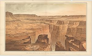
The Grand Ca�on at the Foot of the Toroweap-Looking East.
Published by WashingtonJulius Bien & Co. Lith. New York ., 1882
Seller: Robert Frew Ltd. ABA ILAB, London, United Kingdom
Association Member: ABA ILAB PBFA
Seller rating 5 out of 5 stars
Art / Print / Poster
US$ 1,032.91
US$ 13.37 shipping
Ships from United Kingdom to U.S.A.Quantity: 1 available
Add to basketOriginal double-page chromolithographed panoramic view of the Grand Canyon (overall dimensions 83.5 x 50.5 cm, print dimensions 45 x 75 cm) from Dutton's Atlas to Accompany the Monograph on the Tertiary History of the Grand Ca�on District. Folding down the centre as issued. Ex libris Manchester Geological Society with their library stamp to upper margin. Small loss to upper margin not affecting print, discreet 10 cm tear to left portion stabilised by archival tape, generally very good condition. Clarence E. Dutton began working on his Tertiary History of the Grand Canon District while he was a member of the Powell survey. The Atlas beautifully illustrates the Grand Canyon with the use of color lithography by Julius Bien. The panoramas of the spectacular river gorge are after the paintings of two brilliant topographical artists, W. H. Holmes and Thomas Moran. Tertiary History was important both as a work of art and as the scientific foundation upon which subsequent mapping was based. It is one of the most important cartographic works devoted to the Grand Canyon.
-
[The Grand Canyon]. Panorama from Point Sublime (on three sheets).
Published by WashingtonJulius Bien & Co. Lith. New York ., 1882
Seller: Robert Frew Ltd. ABA ILAB, London, United Kingdom
Association Member: ABA ILAB PBFA
Seller rating 5 out of 5 stars
Art / Print / Poster
US$ 3,443.02
US$ 13.37 shipping
Ships from United Kingdom to U.S.A.Quantity: 1 available
Add to basketOriginal double-page chromolithographed panoramic view of the Grand Canyon comprising three sheets (overall dimensions 83.5 x 50.5 cm, print dimensions 45 x 75 cm) from Dutton's Atlas to Accompany the Monograph on the Tertiary History of the Grand Ca�on District. Each sheet folds down the centre as issued. Part 1 entitled "Looking East", Part 2 "Looking South" and Part 3 "Looking West". Ex libris Manchester Geological Society with two of their library stamps to upper margins of each print. Small marginal nicks and tears not affecting images, generally very good condition. Clarence E. Dutton began working on his Tertiary History of the Grand Canon District while he was a member of the Powell survey. The Atlas beautifully illustrates the Grand Canyon with the use of color lithography by Julius Bien. The panoramas of the spectacular river gorge are after the paintings of two brilliant topographical artists, W. H. Holmes and Thomas Moran. Tertiary History was important both as a work of art and as the scientific foundation upon which subsequent mapping was based. It is one of the most important cartographic works devoted to the Grand Canyon.


![Seller image for [The Grand Canyon]. Panorama from Point Sublime (on three sheets). for sale by Robert Frew Ltd. ABA ILAB](https://pictures.abebooks.com/inventory/md/md31029513133.jpg)