Order Total (1 Item Items):
Shipping Destination:

Empire Map (58 results)
Skip to main search results
Search filters
Product Type
- All Product Types
- Books (21)
- Magazines & Periodicals (No further results match this refinement)
- Comics (No further results match this refinement)
- Sheet Music (No further results match this refinement)
- Art, Prints & Posters (2)
- Photographs (No further results match this refinement)
- Maps (35)
- Manuscripts & Paper Collectibles (No further results match this refinement)
Condition Learn more
- New (No further results match this refinement)
- As New, Fine or Near Fine (No further results match this refinement)
- Very Good or Good (15)
- Fair or Poor (No further results match this refinement)
- As Described (43)
Binding
Collectible Attributes
Language (2)
Free Shipping
- Free Shipping to U.S.A. (No further results match this refinement)
Seller Location
Seller Rating
-

Later ptg. Condition: Very Good. Illustrated by Roman Empire Map End Papers (illustrator). HARDCOVER; 38th impression. VERY GOOD CONDITION RED CLOTHBOUND.clean, solid, name ep "Mrs. Charles Fussman 1945".else no marks.has parts of dj.endpapers & back panel only.; *****NOTE SMALLER SIZE THAN any other hardcover editions, altho follows familar cloth color & design, it is almost vest pocket sized.*** black spine titles on RED CLOTH HARDCOVERS, DECORATED WITH 1" SQUARE DIAMOND DESIGNS.BIT SPINE SLANT. ; 508pg pages; Because she was only fifteen and busy with hergrowing up.Lucia's periods of reflection were brief and infrequent: but this morning she felt weighted with responsibility." first paragraph of book. DUST JACKET REMNANT BACK PANEL HAS 3X4" SEPIA PHOTO OF AUTHOR& HIS VERY LARGE BIBLE.WHIE HE CONSTRUCTS THE STORY OF "THE ROBE".
-
THE BRITISH EMPIRE SHOWING THE GREAT COMMERCIAL HIGHWAYS - an Original Coloured Map, Printed C1908
Language: English
Published by George Philip & Son/The London Geographical Institute, London, 1908
Seller: K Books Ltd ABA ILAB, York, YORKS, United Kingdom
Association Member: ABA ILAB PBFA
Seller rating 5 out of 5 stars

US$ 27.47
US$ 26.00 shipping
Ships from United Kingdom to U.S.A.Quantity: 1 available
Add to basketNo Binding. Condition: Very Good. An original map, printed in full colour, central fold. Shows the areas of the Empires of the World and their populations in c1908.
-
Antique Map of France and the French Empire in 1804
Language: English
Published by Baines, Leeds, 1814
Seller: K Books Ltd ABA ILAB, York, YORKS, United Kingdom
Association Member: ABA ILAB PBFA
Seller rating 5 out of 5 stars
US$ 27.47
US$ 26.00 shipping
Ships from United Kingdom to U.S.A.Quantity: 1 available
Add to basketNo Binding. Condition: Very Good. Splendid original map . Mounted - matted - and ready to frame. Shows France and the French Empire in 1804 - 1814.
-
Roman Empire - Antique Map, Contemporary Colouring 1798
Language: English
Published by R Wilkinson, London, 1801
Seller: K Books Ltd ABA ILAB, York, YORKS, United Kingdom
Association Member: ABA ILAB PBFA
Seller rating 5 out of 5 stars
US$ 41.20
US$ 26.00 shipping
Ships from United Kingdom to U.S.A.Quantity: 1 available
Add to basketNo Binding. Condition: Very Good. J Roper (illustrator). A splendid original antique map of the Roman Empire. Contemporary coloring and in excellent condition. Mounted and ready to frame. Extremely decorative and printed in 1801. Detailed and attractive map subtitled "Romani Imperii Primordia et Recentiora".
-
The History of the Progress and Termination of the Roman Republic. Complete in One Volume. Leather Binding.
Published by Jones & Co., London, 1829
US$ 42.57
US$ 28.00 shipping
Ships from United Kingdom to U.S.A.Quantity: 1 available
Add to basketHalf-Leather. Illustrated with A Frontis Portrait, Extra Illustrated Title Page, Plus a FOLDING MAP OF THE ROMAN EMPIRE. (illustrator). PAGES: viii, 480. Printed in double columns. BINDING: Half leather over marbled boards. CONDITION: Covers worn and lacking half of the spine (see image); inscription to verso of the frontis portrait; offsetting to page facing the folding map; otherwise a clean and tight copy. Size: 8 1/2 X 5 1/2 Inches.(22 x 14 Cms.).
-
Russia and the Russian Empire Map Antique Map
Language: English
Publication Date: 1840
Seller: K Books Ltd ABA ILAB, York, YORKS, United Kingdom
Association Member: ABA ILAB PBFA
Seller rating 5 out of 5 stars
US$ 48.07
US$ 26.00 shipping
Ships from United Kingdom to U.S.A.Quantity: 1 available
Add to basketNo Binding. Condition: Very Good. Antique map . Hand coloured, engraved map. mounted - matted - and ready to frame .12 x 10 inches. a vg copy of an attractive decorative hand coloured antique map. . A splendid map, colouring not contemporary but delicately and expertly done - a fine map of Russia and the Russian Empire.
-
MAP OF THE EMPIRE OF JAPAN - Hand-coloured, Printed in 1859
Language: English
Publication Date: 1859
Seller: K Books Ltd ABA ILAB, York, YORKS, United Kingdom
Association Member: ABA ILAB PBFA
Seller rating 5 out of 5 stars
US$ 54.94
US$ 26.00 shipping
Ships from United Kingdom to U.S.A.Quantity: 1 available
Add to basketNo Binding. Condition: Very Good. A splendid original antique map, mounted (matted) and ready to frame.Colouring not contemporary, but delicately and expertly done. Printed in 1859 by Johnston of Edinburgh, with measurements in miles.
-
Map of the Roman Empire - Fine Detailed Map - an Original Engraving
Language: English
Publication Date: 1840
Seller: K Books Ltd ABA ILAB, York, YORKS, United Kingdom
Association Member: ABA ILAB PBFA
Seller rating 5 out of 5 stars
US$ 54.94
US$ 26.00 shipping
Ships from United Kingdom to U.S.A.Quantity: 1 available
Add to basketNo Binding. Condition: Very Good. A fine engraving - printed circa 1840. Mounted and ready to frame. Hand colouring not contemporary, but delicately and expertly executed. A fine opportunity to purchase an attractive and decorative engraving - Map of the Roman Empire.
-
Eastern Part of the Ancient Persian Empire - an Antique Map
Language: English
Seller: K Books Ltd ABA ILAB, York, YORKS, United Kingdom
Association Member: ABA ILAB PBFA
Seller rating 5 out of 5 stars
US$ 54.94
US$ 26.00 shipping
Ships from United Kingdom to U.S.A.Quantity: 1 available
Add to basketNo Binding. Condition: Very Good. Engraved By Walker (illustrator). A fine antique map in very good condition - printed in circa 1844. Mounted (matted) and ready to frame. Engraved size approx 16 x 13 Ins, 41 x 33 Cms. Mounted size approx 19 x 16 in, 49 x 41cm. Coloured in outline, hand colouring contemporary. A fine engraved map of Eastern Part of the Ancient Persian Empire.
-
Persia - with Part of the Ottoman Empire - an Antique Map
Language: English
Seller: K Books Ltd ABA ILAB, York, YORKS, United Kingdom
Association Member: ABA ILAB PBFA
Seller rating 5 out of 5 stars
US$ 54.94
US$ 26.00 shipping
Ships from United Kingdom to U.S.A.Quantity: 1 available
Add to basketNo Binding. Condition: Very Good. Engraved By Walker (illustrator). A fine antique map in very good condition - printed in circa 1844. Mounted (matted) and ready to frame. Engraved size approx 16 x 13 Ins, 41 x 33 Cms. Mounted size approx 19 x 16 in, 49 x 41cm. Coloured in outline, hand colouring contemporary. A fine engraved map of Persia - with Part of the Ottoman Empire.
-
China - and the Birman Empire - with Parts of Chochin - China and Siam - an Antique Map
Language: English
Seller: K Books Ltd ABA ILAB, York, YORKS, United Kingdom
Association Member: ABA ILAB PBFA
Seller rating 5 out of 5 stars
US$ 61.80
US$ 26.00 shipping
Ships from United Kingdom to U.S.A.Quantity: 1 available
Add to basketNo Binding. Condition: Very Good. Engraved By Walker (illustrator). A fine antique map in very good condition - printed in circa 1844. Mounted (matted) and ready to frame. Engraved size approx 16 x 13 Ins, 41 x 33 Cms. Mounted size approx 19 x 16 in, 49 x 41cm. Coloured in outline, hand colouring contemporary. A fine engraved map of China - and the Birman Empire - with Parts of Chochin - China and Siam.
-
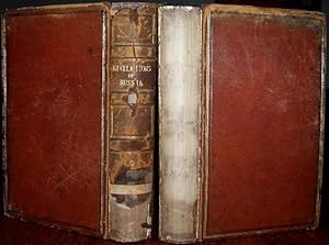
REVELATIONS OF RUSSIA: or, The Emperor Nicholas and His Empire in 1844, By An English Resident. In Two Volumes. London, 1845. Full Leather Binding.
Published by Henry Colburn, 1845
US$ 89.27
US$ 28.00 shipping
Ships from United Kingdom to U.S.A.Quantity: 1 available
Add to basketHardcover. Condition: Good. Illustrated with a Frontis Plate to Each Volume Plus a Folding MAP of the Russian Empire. (illustrator). 2nd Edition. PAGES: xxxii, 394; iv, 380. BINDING: Full Leather. CONDITION: IN NEED OF RE-BINDING; Lacking part of the spine in first volume and all the spine in the second; Bookplate to front pastedown, inscription to front blank endpaper of both volumes; foxing to first and last few pages (including the plates and map), elsewhere occasional light foxing. Size: 7 3/4 X 4 3/4 Inches.
-

Russian Empire. Original two-part map of the Russian Empire published by W.H. Lizars in 1843. European side only with Channel of the Dardenelles below. With contemporary hand-colouring.
Published by W.H. Lizars., 1843
Map First Edition
US$ 116.74
US$ 15.33 shipping
Ships from United Kingdom to U.S.A.Quantity: 1 available
Add to basketSoft cover. Condition: Good. 1st Edition. 47x57cm. Wear and fraying at edges with short tears.
-
Empire of Japan - Yedo and Meaco - an Antique Map
Language: English
Seller: K Books Ltd ABA ILAB, York, YORKS, United Kingdom
Association Member: ABA ILAB PBFA
Seller rating 5 out of 5 stars
US$ 82.40
US$ 26.00 shipping
Ships from United Kingdom to U.S.A.Quantity: 1 available
Add to basketNo Binding. Condition: Very Good. Engraved By Walker (illustrator). A fine antique map in very good condition - printed in circa 1844. Mounted (matted) and ready to frame. Engraved size approx 16 x 13 Ins, 41 x 33 Cms. Mounted size approx 19 x 16 in, 49 x 41cm. Coloured in outline, hand colouring contemporary. A fine engraved map of Empire of Japan - Yedo and Meaco.
-
MAP OF RUSSIAN EMPIRE - Original Antique Map, Printed c 1785
Language: English
Publication Date: 1785
Seller: K Books Ltd ABA ILAB, York, YORKS, United Kingdom
Association Member: ABA ILAB PBFA
Seller rating 5 out of 5 stars
US$ 123.60
US$ 26.00 shipping
Ships from United Kingdom to U.S.A.Quantity: 1 available
Add to basketNo Binding. Condition: Very Good. Original antique map, engraved for Millar's New Complete & Universal System of Geography. Colouring not contemporary, but delicately and expertly done. Mounted (matted) and ready to frame. Cartouche. No date of publication. Extends from Sweden in the West to include Japan in the East.
-
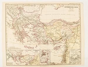
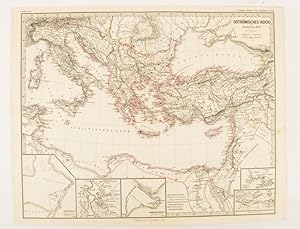
Ostr�misches Reich 1096-1204
Published by Justus Perthes, Gotha, 1876
Seller: Asia Bookroom ANZAAB/ILAB, Canberra, ACT, Australia
Association Member: ANZAAB ILAB
Seller rating 5 out of 5 stars
Map with original colour and outline hand-colour, 32.2 x 40 cm, text in German, four inset maps, central fold, slight marginal toning, and spotting on the verso, but in very good condition. A most handsome and highly detailed map detailing the Eastern provinces of the Byzantine/Roman Empire before the Fourth Crusade. The inset maps depict Constantinople, Divisions of the Empire, and Antioch, issued for the "Hand-Atlas f�r die Geschichte des Mittelatters und die Neueren Zeit".
-
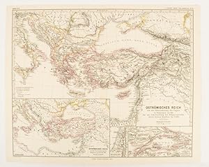
Ostr�misches Reich von der Einwanderung der Ungarn in Ponnonien um 895 bis zur Unterwerfung des Bulgarenreichs durch Kaiser Basilius im J. 1019.
Published by Justus Perthes, Gotha, 1874
Seller: Asia Bookroom ANZAAB/ILAB, Canberra, ACT, Australia
Association Member: ANZAAB ILAB
Seller rating 5 out of 5 stars
Map with original colour and outline hand-colour, 32.2 x 40 cm, three inset maps, text in German, central fold, slight marginal toning, in very good condition. A most handsome map detailing the Eastern Roman Empire from the immigration of Hungarians in Ponnonia around 895 to the subjugation of the Bulgarian Empire by Emperor Basilius in 1019. The inset maps depict Divisions of the Empire, Palestine, and the Themata around Propontis (present day Sea of Marmara), issued for the "Hand-Atlas f�r die Geschichte des Mittelatters und die Neueren Zeit".
-
Ostr�misches Reich zu Justinians Zeit.
Published by Justus Perthes., Gotha.
Seller: Asia Bookroom ANZAAB/ILAB, Canberra, ACT, Australia
Association Member: ANZAAB ILAB
Seller rating 5 out of 5 stars
Map with original colour and outline hand-colour, 32.2 x 40 cm, text in German, five inset maps, central fold, slight marginal toning, and spotting on the verso, but in very good condition. A most handsome and highly detailed map detailing the Eastern provinces of the Byzantine/Roman Empire in the time of the Roman Emperor Justinian 527-565. The inset maps depict Carthage, Rome, Constantinople, Naples, and a Western continuation of the main map, originally issued for the "Hand-Atlas f�r die Geschichte des Mittelatters und die Neueren Zeit".
-

New World School Map of Europe
Published by New York c.1925, New York, 1925
Seller: High Ridge Books, Inc. - ABAA, South Deerfield, MA, U.S.A.
Association Member: ABAA ESA ILAB SNEAB
Seller rating 5 out of 5 stars
100x132 cm. Wall map of Europe dissected and backed with linen with brass eyelets for hanging. Folds to six sections. Bright full color by country. fine condition with light soiling to linen. The USSR is named only as Russia, indicating that the USSR had not yet gained full acceptance. St. Petersburg is shown both as Petrograd and Leningrad, indicating that this map was published around the time the name was changed in 1925. Also, Tsaritzyn is shown, not Stalingrad as it was renamed in 1925.
-

Sales Map of Manhattan
Published by Teaneck, NJ c. 1931, Teaneck, NJ, 1931
Seller: High Ridge Books, Inc. - ABAA, South Deerfield, MA, U.S.A.
Association Member: ABAA ESA ILAB SNEAB
Seller rating 5 out of 5 stars
Large map of Manhattan with street directory at the bottom. Good condition only, with tears and some chipping at the bottom. Uncolored. The map is divided horth and south, with the southern half of the island on the left side of the sheet, the northern half on the right.
-
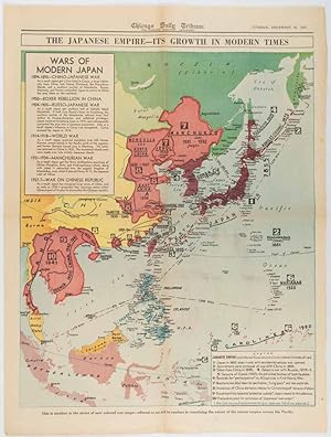
The Japanese Empire -- Its Growth in Modern Times
Published by Chicago Daily Tribune. December 161941., Chicago., 1619
Seller: Asia Bookroom ANZAAB/ILAB, Canberra, ACT, Australia
Association Member: ANZAAB ILAB
Seller rating 5 out of 5 stars
Printed colour map on a single newspaper leaf 50 x 41.5 cm; 60 x 45 cm (sheet), two inset legends, marginal browning and at the folds, but remarkably bright, in very good condition. Map of the Japanese Empire published in the Chicago Daily Tribune "The World's Greatest Newspaper" on December 16th 1941, 9 days after the bombing of Pearl Harbour. The two legends list the "Wars of Modern Japan" from 1894, with territorial gains marked, noting that "Each seizure of mainland areas has given Japan new field of raw materials." "? the historic Chicago Tribune was an innovator in color inks and printing, but also a pioneer in bringing colorful art in the form of illustrations, photographs, cartoons and advertisements to the average person in an everyday medium." [see The Janet A. Ginsburg Chicago Tribune Collection, Michigan State University Libraries.].
-
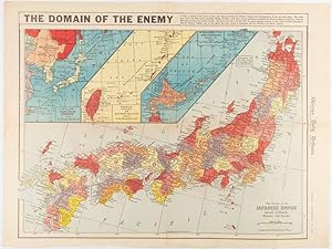
The Domain of the Enemy
Published by Chicago Daily Tribune. December 121941., Chicago., 1219
Seller: Asia Bookroom ANZAAB/ILAB, Canberra, ACT, Australia
Association Member: ANZAAB ILAB
Seller rating 5 out of 5 stars
Printed colour map on a single newspaper leaf 41.5 x 53 cm; 45.1 x 59.9 cm (sheet), three inset maps of the Japanese Empire; Taiwan and Ryukyu Islands; and Hokkaido and Chisima, marginal browning and at the central fold, but remarkably bright, in very good condition. Map of the Japanese Empire, ominously titled, published in the Chicago Daily Tribune one week after the bombing of Pearl Harbour. Prefectures are attractively coloured. Based on a Rand McNally map, the Tribune briskly got to work issuing maps for readers showing the beginnings of the war with Japan. Later maps were also published for sale separately, but remarkably few have survived. ". the historic Chicago Tribune was an innovator in color inks and printing, but also a pioneer in bringing colorful art in the form of illustrations, photographs, cartoons and advertisements to the average person in an everyday medium." [see The Janet A. Ginsburg Chicago Tribune Collection, Michigan State University Libraries.].
-

Verschiedene Prospekte der vornemsten St�dten in Persien.
Published by Nuremberg [1762]., 1762
Seller: H�nersdorff Rare Books ABA ILAB, London, United Kingdom
Seller rating 3 out of 5 stars

Art / Print / Poster
US$ 1,304.71
US$ 30.00 shipping
Ships from United Kingdom to U.S.A.Quantity: 1 available
Add to basketNo Binding. Condition: Very Good. Engraving comprising 15 aerial city views with captions in German below. Original wash colour: images in green, text panels in pink, surrounding border in yellow. Image size: 49 x 58 cm; overall size: 53.5 x 62.5 cm. Fifteen views of prominent cities within the former Persian Empire arranged on one sheet, including Astrachan (Astrakhan, southern Russia), Derbent (Dagestan), Teflis (Tbilisi, Georgia), Kars (northeastern Turkey), Erzerum (Erzurum, northeastern Turkey), Baccu (Baku, Azerbaijan), Sultania (Soltaniyeh, Iran), Schmachia (Shamakha, Azerbaijan), Erivan (Yerevan, Armenia), Schiraz (Shiraz, Iran), Candahar (Kandahar, Afghanistan), Ardebii (Aardabil, Iran), Kachan (Kashan, Iran), Isphahan (Esfahan, Iran);Gamron / Bender Abassi (Bandar Abbas, Iran). Isfahan is shown considerably larger than the other cities as the actual capital of the Empire. Shiraz is identified as the ancient city of Persepolis, a former capital. Below each view are indicated the principal points of interest such as city gates and walls, rivers, royal palaces, and markets. The Safavids controlled the area of modern Iran, Azerbaijan, Armenia, Afghanistan, most of Georgia, and parts of Turkey. Homann was the outstanding German map publisher in the 18th century. Very well preserved; 2 tiny holes in top blank margin.
-

Hispania.
Publication Date: 1852
Seller: Geographicus Rare Antique Maps, Brooklyn, NY, U.S.A.
Association Member: ABAA ESA ILAB
Seller rating 4 out of 5 stars

Map
Very good. Minor overall toning. Blank on verso. Size 9 x 11 Inches. This is a fine 1852 map of Hispania or Spain under the Roman Empire by Joseph Meyer. It depicts the Iberian Peninsula under the Roman Empire from the Atlantic Ocean to the Mediterranean Sea, including the Balearic Islands of Ibiza, Majorca and Minorca. The Roman provinces of Tarraconensis, Baetica and Lusitania are identified. This highly detailed map notes several rivers, ancient towns, cities and other topography, with elevation rendered by hachure. Although the Romans controlled most of the Iberian Peninsula from about 218 BC, it took them close to two centuries to fully subjugate the region. This map was issued in Meyer's Zeitung Atlas . Although all the maps in this atlas are not individually dated, the title page and maps were often updated while the imprint with the date was not, causing confusion to the exact date for some of the maps. Moreover some maps in the atlas were taped in at a later date as an update to the atlas. We have dated the maps in this collection to the best of our ability.
-

Hispania.
Publication Date: 1867
Seller: Geographicus Rare Antique Maps, Brooklyn, NY, U.S.A.
Association Member: ABAA ESA ILAB
Seller rating 4 out of 5 stars
Map
Very good. Minor wear and toning along original centerfold. Size 10 x 13 Inches. This is a lovely 1867 map of Hispania or Spain and Portugal by William Hughes. The map depicts the Iberian Peninsula under the Roman Empire from the Atlantic Ocean to the Mediterranean Sea, including the Balearic Islands. The Roman provinces of Tarraconensis, Baetica and Lusitania are identified. Although the Romans controlled most of the Iberian Peninsula from about 218 BC, it took them close to two centuries to fully subjugate the region. This map was created by William Hughes, printed by J. Bien and engraved by G.E. Sherman, for issued as plate 7 in Sheldon and Company's An Atlas of Classical Geography .
-
Karte des Ottomanischen / T�rkischen Reiches. Sie zeigt das Gebiet zwischen Spanien, der Ukraine, dem Kaspischen Meer, der Arabischen Halbinsel und Algerien.
Seller: Antiquariat Martin Barbian & Grund GbR, Saarbruecken, Germany
Seller rating 5 out of 5 stars
Art / Print / Poster
Kupferstich von Tho. Bowen, London, um 1780, 31,5x42 cm (etwas gebr�unt, in den beiden Falzen etwas leimschattig und leicht knittrig).
-

Carte de L'Afrique Propre de la Numidie et D'une Partie de la Mauritanie.
Publication Date: 1829
Seller: Geographicus Rare Antique Maps, Brooklyn, NY, U.S.A.
Association Member: ABAA ESA ILAB
Seller rating 4 out of 5 stars
Map
Very good condition. Original pressmark visible. Wide margins. Blank on verso. Size 16 x 21.5 Inches. An unusual and attractive 1829 map of the ancient empires of Mauritania, Carthage, and Numidia. Depicts what is today known as the Barbary Coast around 200 BC. This map illustrates a crucial turning point early in the Second Punic War. The Carthaginian Empire dominated much of the region, until Numidia, the Kingdom to the west of Carthage, allied itself with Rome in 206 BC leading the Roman conquest of the region in 201 BC. Exhibits the typical detail and scientific precision of Lapie maps. Notes various trade routes, topographical features, and Oases. Prepared as plate no. 14 for the 1829 issue of Lapie's Atlas Universel de Geographie Ancienne et Moderne. References: Rumsey 2174.014. Phillips (Atlases) 754 and 765.
-

Empire d'Allemagne (Ancienne Confederation Germanique).
Publication Date: 1878
Seller: Geographicus Rare Antique Maps, Brooklyn, NY, U.S.A.
Association Member: ABAA ESA ILAB
Seller rating 4 out of 5 stars
Map
Very good. Original centerfold. Blank on verso. Size 17 x 12 Inches. This is a fine example of J. Migeon's 1878 map of the German empire. It covers the German Confederation from the Baltic Sea to the Adriatic Sea and from France to the Austro-Hungarian empire. The lower left quadrant features a table listing the states of the German Confederation. In the upper right quadrant there is a beautiful decorative illustration of Mayence (Mainz). The German Confederation, created in 1814, acted as a buffer zone between Austria and Prussia, its two largest and most powerful member states. Nonetheless the rivalry between the two powerful states intensified until the outbreak of the Austro-Prussian War. Prussia won the Austro-Prussian War in 1866, ultimately leading to the collapse of the German Confederation. A few years later, in 1871, most of the former Confederation states were folded into the newly proclaimed German empire. Migeon identifies various railway lines, rivers, mountain passes and other topographical features. Migeon's Geographie Universelle , published in Paris, is one of the last great decorative atlases of the 19th century. It contains many stylistic elements of early 19th century cartography such as full hand coloring, numerous decorative vignettes, and high quality paper. This map was issued as plate no. 19 in Migeon's Geographie Universelle .
-

Asien bei Beginn des zweiten jahrhunderts vor Christus. Zeit der Seleuciden und des Turk Reiches der Hiong-nu in Hoch-Asien.
Publication Date: 1855
Seller: Geographicus Rare Antique Maps, Brooklyn, NY, U.S.A.
Association Member: ABAA ESA ILAB
Seller rating 4 out of 5 stars
Map
Fine or perfect condition. Margins wide. Blank on verso. Size 14 x 17 Inches. This fascinating hand colored map depicts Asia at the beginning of the 2nd century B.C.E. This period corresponds with the Han dynasty of China, the rise of the Hiongnu Empire in Mongolia, and the Seleucid Turk Empire in Persia. All text is in German, but the title roughly translates as 'Asia with beginning of the second century before Christ. Time of the Seleuciden and the Turk of realm Hiong-nu in High Asia.' Map was originally part of the 1855 edition of Karl von Spruner's Historical Hand Atlas.
-

Asien gegen die Mitte des Funften Jahrhunderts. Zeit der Sassaniden und des Hunnen-Reiches.
Publication Date: 1855
Seller: Geographicus Rare Antique Maps, Brooklyn, NY, U.S.A.
Association Member: ABAA ESA ILAB
Seller rating 4 out of 5 stars
Map
Fine or perfect condition. Margins wide. Blank on verso. Size 14 x 17 Inches. This fascinating hand colored map depicts Asia at the middle of the 5th century. This period corresponds with the period of the great Sassanid Empire and the Song dynasty of China. The Sassanid were a Zoroastrian Persian dynasty hailing from modern day Iran. All text is in German. Map was originally part of the 1855 edition of Karl von Spruner's Historical Hand Atlas.