Order Total (1 Item Items):
Shipping Destination:

Esnauts (6 results)
Author:
esnauts
Refine with Advanced Search
Skip to main search results
Search filters
Product Type
- All Product Types
- Books (2)
- Magazines & Periodicals (No further results match this refinement)
- Comics (No further results match this refinement)
- Sheet Music (No further results match this refinement)
- Art, Prints & Posters (1)
- Photographs (No further results match this refinement)
- Maps (3)
- Manuscripts & Paper Collectibles (No further results match this refinement)
Condition Learn more
- New (No further results match this refinement)
- As New, Fine or Near Fine (No further results match this refinement)
- Very Good or Good (2)
- Fair or Poor (No further results match this refinement)
- As Described (4)
Binding
- All Bindings
- Hardcover (1)
- Softcover (No further results match this refinement)
Collectible Attributes
- First Edition (1)
- Signed (No further results match this refinement)
- Dust Jacket (No further results match this refinement)
- Seller-Supplied Images (5)
- Not Print on Demand (6)
Language (1)
Price
- Any Price
- Under US$ 25 (No further results match this refinement)
- US$ 25 to US$ 50 (No further results match this refinement)
- Over US$ 50
Free Shipping
Seller Location
Seller Rating
-
PARIS: Nouveau plan routier de la ville et fauxbourgs de Paris. Paris,
Published by Paris, rue Saint Jacques � la ville de Coutances, 1784
Map
Couverture rigide. Condition: Assez bon. Carte originale de la ville de Paris et de ses environs; mont�e sur toile en 24 sections; dimensions environ 55,5 x 80,5 mm; carte en tr�s bon �tat g�n�ral, papier bien conserv�, sans t�ches, usures aux pliures de la toile, en particulier au premier niveau des pliures, o� la toile est perc�e en plusieurs endroits; les coins des segments de papier voisins n'ont pratiquement pas �t� atteints, un seul endroit avec une usure minime; la carte est accompagn�e de son �tui cartonn� d'origine, t�ch� et avec de fortes usures, mais qui n'en conserve pas moins son aspect d'origine; Cartouche de titre orn� en t�te des armoiries de Paris sur fond de fleurs de lys et table alphab�tique des rues des deux c�t�s de la carte; une fen�tre est consacr�e � la banlieue de Paris;
-

Nouveau Plan Routhier de la Ville de Fauxbourgs de Paris. Se vend a Paris, chez Esnauts et Rapilly rue St. Jacques, a la Ville de Coutances. 1792. Avec Privilege du Roi.
Published by Esnauts et Rapilly, Paris, 1792
Seller: Kurt Gippert Bookseller (ABAA), Chicago, IL, U.S.A.
Association Member: ABAA ILAB MWABA
Seller rating 5 out of 5 stars

First Edition
No Binding. Condition: Very good- condition. First thus edition. Large antique fold-out map of Paris. Measures 31.5 x 21.5 inches, in 23 of 24 sections. Lacks the lower left corner section. Linen backed. Outline hand-color folding map. Inset overview of Paris, and tables at right and left margins. Book.
-

Plan de Gibraltar attaqu� par Terre et par Mer par l'arm�e Espagnole et Fran�aise aux Ordres de Mr. le Duc de Crillon, en pr�sence de Mgr. le Comte d'Artois d'apr�s les Dessins d'un Ing�nieur en Chef de l'Arm�e.
Published by � ParisChez Esnauts et Rapilly ., 1782
Seller: Robert Frew Ltd. ABA ILAB, London, United Kingdom
Association Member: ABA ILAB PBFA
Seller rating 5 out of 5 stars
Map
US$ 1,242.80
US$ 13.41 shipping
Ships from United Kingdom to U.S.A.Quantity: 1 available
Add to basketTwo engraved maps of Gibraltar on one sheet with contemporary hand-colour (overall dimensions 78 x 55 cm, map dimensions together 74 x 51 cm). The map on the left shows the Bay of Gibraltar from which the French and Spanish fleets bombard the British garrison, while the map on the left shows a town plan of Gibraltar and its immediate environs. Folded once vertically and once horizontally. Light toning and occasional light spotting, two tiny holes to map on left, generally very good. A separately issued engraved map of the Great Siege of Gibraltar, prepared in 1783 by the Parisian mapmaker Esnauts and Rapilly, well known for their scarce maps of the American Revolution. The Great Siege of Gibraltar was an unsuccessful attempt by Spain and France to capture Gibraltar from the British during the American War of Independence. The British garrison under George Augustus Eliott were blockaded from June 1779 to February 1783, initially by the Spanish alone, led by Mart�n �lvarez de Sotomayor. The blockade failed because two relief convoys entered unmolestedthe first under Admiral George Rodney in 1780 and the second under Admiral George Darby in 1781despite the presence of the Spanish fleets. The same year, a major assault was planned by the Spanish, but the Gibraltar garrison sortied in November and destroyed much of the forward batteries. With the siege going nowhere and constant Spanish failures, the besiegers were reinforced by French forces under de Crillon, who took over command in early 1782. After a lull in the siege, during which the allied force gathered more guns, ships and troops, a "Grand Assault" was launched on 18 September 1782. This involved huge numbers60,000 men, 49 ships of the line and ten specially designed, newly invented floating batteriesagainst the 5,000 defenders. The assault was a disastrous failure, resulting in heavy losses for the Bourbon allies. The siege then settled down again to more of a blockade, but the final defeat for the allies came when a crucial British relief convoy under Admiral Richard Howe slipped through the blockading fleet and arrived at the garrison in October 1782. The siege was finally lifted on 7 February 1783 and was a decisive victory for the British forces, being a vital factor in the Peace of Paris, which had been negotiated towards the end of the siege. This was the largest action fought during the war in terms of numbers, particularly the "Grand Assault". At three years and seven months, it is the longest siege endured by the British Armed Forces and one of the longest sieges in history.
-
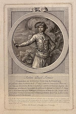
John Paul Jones, Commodore au service des Etats-Unis de l'Amerique
Published by Esnauts et Rapilly, Paris
Seller: Argosy Book Store, ABAA, ILAB, New York, NY, U.S.A.
Seller rating 5 out of 5 stars
Engraving. Image measures 8" x 5 1/4". Sheet measures 11 1/2" x 8 5/8". Stains and repairs to margins, not affecting the image, otherwise in good condition. This remarkable 18th century engraving shows John Paul Jones, a prominent US naval commander in the American Revolutionary War. Jones is depicted in this half-length portrait with his hand outstretched, holding a sword, standing aboard a ship during battle. Other ships are visible in the background, with smoke billowing through the air. The text, in French, describes the September 23, 1779 battle between Jones' Bonhomme Richard and Serapis, a British frigate led by Captain Pearson. The French admired Jones for his heroism and celebrated his success. LOC: 2003689054.
-

Florence ville d'Italie, Capitale de Toscane�
Published by Parigi,, 1770
Seller: libreria antiquaria perini Sas di Perini, Verona, VR, Italy
Seller rating 5 out of 5 stars
Art / Print / Poster
Incisione in rame, colorata d'epoca, 345x530. Non comune bella veduta della citt? presa dalla prospettiva classica, che fin dal Cinquecento fu la preferita dagli artisti. Perfettamente conservata. Nr.cat: P4090047.
-
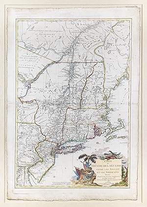
Carte du Theatre de la Guerre entre les Anglais et les Americains
Publication Date: 1778
Seller: Arader Galleries - AraderNYC, New York, NY, U.S.A.
Seller rating 5 out of 5 stars
Map
No Binding. Condition: Good. Engraved map with original hand coloring. [Paris: 1778] Esnauts & Rapilly's scarce, separately published, and attractive map of the Northeast, produced to inform the French public of the primary theatre of the early years of the American Revolution. The map illustrates the area from Quebec to Cape May, New Jersey, and from the Kennebec River to Lake Ontario. Boundaries, counties, towns and cities, forts, roads, and Indian nations are all depicted in great detail. According to Nebenzahl and Sellers Van Ee, this map should show the location of British troops at Frank-Fort and German Town in Pennsylvania and at Saratoga in New York, however this first state of the map only includes the troop positions in red manuscript. Numerous forts, minor are shown and named throughout the map, including Fort Washington in northern Manhattan, those along the Delaware River, many in northern Massachusetts and the several in the Lake Champlain - Lake George region. Numerous major and minor cities including New York, Philadelphia, Albany, New Haven, Newport, and Boston, are shown as walled cities.