Frederic Wit (24 results)
 More images
Seller: Berliner Büchertisch eG, Berlin, GermanyBerliner Büchertisch eG
Contact seller5-star sellerCondition: Used - Very good
US$ 11.30
US$ 114.22 shippingShips from Germany to U.S.A.Quantity: 1 available
CD-Hülle. Condition: Gut. Versand im Luftpolsterumschlag! CD-Hülle etwas berieben, Disc ist in einem guten Zustand; Case shows some wear, disc in good condition H260210cdm108 ISBN: 747313233670 Sprache: Englisch Gewicht in Gramm: 94.
 More images
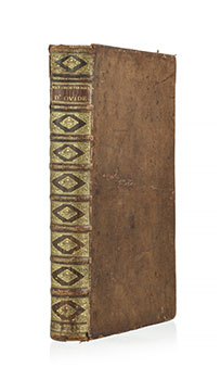
LES // METAMORPHOSES // D'OVIDE, // EN LATIN, // TRADUITES EN FRANÇOIS, // AVEC DES REMARQUES, // ET DES // EXPLICATIONS HISTORIQUES. // PAR MR. L'ABBE BANIER,// DE L'ACADEMIE ROYALE DES INSCRIPTIONS // ET BELLES LETTRES. // Ouvrage enrichi de Figures en taille douce, // Gravées par B. PICART, & autres habiles Maitres. // TOME PREMIER [and ] [SECOND] // [vignette] // A AMSTERDAM. 2 volumes in one. First edition.
Ovid; Ovide; M. l'abbé Banier, authors; Jacob Folkema (1692-1767); Balthasar Bernaerts (c.1711-1737);Wouter Jongman (engraving c.1712-1744), Joseph Mulder (c.1659/60?); Jan Schenk (engraving c.1731-1746); Jan Wandelaar (1690-1759), Philip Van Gunst (1685-1732); the Flemish: Martin Bouche (c. 1640-1693), Frederic Bouttats (c.1610-1675), Peter Paul Bouche (c.1646), and the French: Bernard Picart (1673-1733); after the works of the Dutch: Louis Fabritius Dubourg (1693-1775); Godfried Maes (16491-700); Jan Punt (1711-1779); Jacob De Wit (1695-1754); the French: Charles LeBrun (1619-1690); Sebastien Leclerc (1637-1714); and the Italians: Giulio Romano (1499-1546); and Pietro Testa (1612-1650),artists
Published by Amsterdam : Printed for the Wetsteins and Smith, MDCCXXXII. [1732], 1732
- Hardcover
Seller: Wittenborn Art Books, San Francisco, CA, U.S.A.Wittenborn Art Books
Contact seller5-star sellerCondition: Used - Good
US$ 5,000.00
US$ 10.00 shippingShips within U.S.A.Quantity: 1 available
Condition: Good. Folio. . Contemporary roan with gilt spine, worn along edges of spine, but tight Pages fresh and crisp. Very good. Bookplates and old ink inscription of previous private owners on inside front cover. 30 x 48.5 cm. Text in French and Latin. . See collation below.OCLC only lists the English language edtion of the…same year.References : Brunet III: 599; Cohen de Ricci: 768. .In -folio relié pleine basane brune, dos à nerfs orné et doré (Reliure de l'époque). [5] ff., 247 pp., [1] f., (249 254) pp., [2] ff. Orné d'un frontispice, une vignette armoriée de dédicace et de 130 figures in texte à mi-page d'après Lebrun, Leclere, Maas, Picard, Punt, J. Romain, Tosca, de Wit and Vandelaar par divers sculpteurs. Edition bilingue francol-atine imprimée sur 2 colonnes. Bon état, oxydation des ff. et rousseurs, usures à la reliure.

Published by de Wit, Amsterdam, 1680
- Map
Seller: Antiquariat Reinhold Berg eK Inh. R.Berg, Regensburg, GermanyAntiquariat Reinhold Berg eK Inh. R.Berg
Contact seller5-star sellerCondition: Used
US$ 211.76
US$ 27.41 shippingShips from Germany to U.S.A.Quantity: 1 available
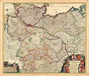
Original Copperplate Engraving by Frederic de Wit, depicting Circulus Saxoniae, Inferioris in quo sunt Ducatus Holsatiae, Meklenburgi, Lauwendurgi, Luneburgi, Brunsuigi, Bremae et Ferdae, Comitatus Dannebergi, Archiepiscopatus Maegdenburgensis, Episcopatus Hildesiae et Halberstad Per F. de Wit. Published Amsterdam, de Wit, 1680.… Sheet: 495 by 575mm (19 by 22 inches). A fine and example of de Wit's celebrated cartographic work, documenting this region of Germany with the precision and decorative artistry characteristic of the 16800s. Frederick de Wit (c.1630-1706) was a Dutch cartographer and publisher based in Amsterdam, one of the most important map publishers of the later Dutch Golden Age. He produced a large number of maps and atlases from the 1660s onwards, many of which were later republished by Covens & Mortier and other Amsterdam publishers. His maps are known for their fine engraving quality and are considered among the best examples of late 17th-century Dutch cartography.This original copperplate engraving depicts the region of Circulus Saxoniae, Inferioris in quo sunt Ducatus Holsatiae, Meklenburgi, Lauwendurgi, Luneburgi, Brunsuigi, Bremae et Ferdae, Comitatus Dannebergi, Archiepiscopatus Maegdenburgensis, Episcopatus Hildesiae et Halberstad Per F. de Wit., published in Amsterdam, de Wit, 1680. The map features a decorative Baroque cartouche containing the title inscription. A distance scale is incorporated within the cartouche or alongside it. The cartouche is elaborated with allegorical or figural ornamentation. The map records the political and geographic boundaries of the region as understood in 1680, offering a fascinating window into the history of German territorial organization. Sheet measures 495 by 575mm (19 by 22 inches). In good condition overall, with minor signs of age appropriate for a 17th-century engraving. Ready to frame. Trimmed top and bottom. Sheet browned throughout. Small corner tear at bottom right, outside the illustration. Two small brown spots at the bottom left of the leaf edge. Some small creases on the center fold. 495 by 575mm (19 by 22 inches). 495 by 575mm (19 by 22 inches).

Published by Amsterdam,, 1750
- Art / Print / Poster
Seller: libreria antiquaria perini Sas di Perini, Verona, VR, Italylibreria antiquaria perini Sas di Perini
Contact seller5-star sellerCondition: Used
US$ 352.93
US$ 45.69 shippingShips from Italy to U.S.A.Quantity: 1 available
Incisione in rame, colorata d'epoca ai confini, mm. 495x575. Ben conservata, con dello sporco superficiale al margine sinistro e una piccola crepa nella battuta visibile solo in controluce. Nr.cat: 100_6897.
Published by de Wit, Amsterdam, 1680
- Map
Seller: Antiquariat Reinhold Berg eK Inh. R.Berg, Regensburg, GermanyAntiquariat Reinhold Berg eK Inh. R.Berg
Contact seller5-star sellerCondition: Used
US$ 470.57
US$ 27.41 shippingShips from Germany to U.S.A.Quantity: 1 available
Other. Hand-Colored Original Copperplate Engraving by Frederic de Wit, depicting Circulus Saxoniae, Inferioris in quo sunt Ducatus Holsatiae, Meklenburgi, Lauwendurgi, Luneburgi, Brunsuigi, Bremae et Ferdae, Comitatus Dannebergi, Archiepiscopatus Maegdenburgensis, Episcopatus Hildesiae et Halberstad Per F. de Wit. Published Amst…erdam, de Wit, 1680. Sheet: 495 by 575mm (19 by 22 inches). A fine and original hand-colored example of de Wit's celebrated cartographic work, documenting this region of Germany with the precision and decorative artistry characteristic of the 16800s. Frederick de Wit (c.1630-1706) was a Dutch cartographer and publisher based in Amsterdam, one of the most important map publishers of the later Dutch Golden Age. He produced a large number of maps and atlases from the 1660s onwards, many of which were later republished by Covens & Mortier and other Amsterdam publishers. His maps are known for their fine engraving quality and are considered among the best examples of late 17th-century Dutch cartography.This original copperplate engraving, with original hand coloring depicts the region of Circulus Saxoniae, Inferioris in quo sunt Ducatus Holsatiae, Meklenburgi, Lauwendurgi, Luneburgi, Brunsuigi, Bremae et Ferdae, Comitatus Dannebergi, Archiepiscopatus Maegdenburgensis, Episcopatus Hildesiae et Halberstad Per F. de Wit., published in Amsterdam, de Wit, 1680. The map features a decorative Baroque cartouche containing the title inscription. A distance scale is incorporated within the cartouche or alongside it. The cartouche is elaborated with allegorical or figural ornamentation. The map records the political and geographic boundaries of the region as understood in 1680, offering a fascinating window into the history of German territorial organization. Sheet measures 495 by 575mm (19 by 22 inches). In good condition overall, with minor signs of age appropriate for a 17th-century engraving. Ready to frame. Near the centerfold one is crease slightly visible else in excellent condition. 495 by 575mm (19 by 22 inches). 495 by 575mm (19 by 22 inches).
Published by Amsterdam, 1680
- Art / Print / Poster
Seller: libreria antiquaria perini Sas di Perini, Verona, VR, Italylibreria antiquaria perini Sas di Perini
Contact seller5-star sellerCondition: Used
US$ 529.39
US$ 45.69 shippingShips from Italy to U.S.A.Quantity: 1 available
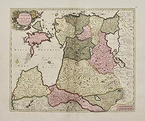
Incisione in rame, mm 420x510, dipinta a mano d'epoca. Fascinosa carta di Estonia e Lettonia in bella coloritura con restauri integrativi e rinforzi alla piega centrale, alcuni altri punti rinforzati in carta cina a caudsa dell'ossidazione del colore.Copper engraving, mm 420x510, original colour. Decorative map of the Baltic reg…ion, covering Estonia and the northern part of Latvia. Intop left corner a cartouche with coats-of-armsSome restorations with manuscript insertions and reinforcements at centerfold Nr.cat: 6678.
Published by Amsterdam, 1710
- Art / Print / Poster
Seller: libreria antiquaria perini Sas di Perini, Verona, VR, Italylibreria antiquaria perini Sas di Perini
Contact seller5-star sellerCondition: Used
US$ 552.92
US$ 45.69 shippingShips from Italy to U.S.A.Quantity: 1 available
Incisione in rame, finemente colorata a mano, mm 470x560. Due bei cartigli figurati negli angoli di destra. Tratta da "Atlas sive Descriptio Terrarum Orbis". De Wit fu uno dei pi? noti cartografi della seconda met? del '600; acquistÚ molte lastre da Blaeu e Jansonius, producendo molti atlanti. Esemplare ottimo, con minimo rinfor…zo alle estremit? della piega centrale e piccolo alone in alto. Nr.cat: P6150025.

Published by Amsterdam, 1680
- Art / Print / Poster
Seller: libreria antiquaria perini Sas di Perini, Verona, VR, Italylibreria antiquaria perini Sas di Perini
Contact seller5-star sellerCondition: Used
US$ 588.21
US$ 45.69 shippingShips from Italy to U.S.A.Quantity: 1 available
Incisione in rame, colorata d'epoca a tutto campo, 490x600. Bel cartiglio allegorico in basso a sinistra che riporta anche la scala delle miglia. Tratta da "Atlas sive Descriptio Terrarum Orbis". De Wit fu uno dei pi? noti cartografi della seconda met? del '600, acquistÚ molte lastre da Blaeu e Jansonius producendo molti atlanti…. Esemplareottimo, brunitura in corrispondenza di Freiuls, lieve alone al margine in basso, piccolo restauro alla parte inf. lungo la piega centrale; margini brevi eccetto quello inferiore. Nr.cat: 100_6882.

Published by Amsterdam, 1680
- Art / Print / Poster
Seller: libreria antiquaria perini Sas di Perini, Verona, VR, Italylibreria antiquaria perini Sas di Perini
Contact seller5-star sellerCondition: Used
US$ 1,058.78
US$ 45.69 shippingShips from Italy to U.S.A.Quantity: 1 available
Incisione in rame, finemente colorata a mano d'epoca a tutto campo, mm 500x615. Elegante cartiglio figurato nell'angolo sup. sin. Tratta da "Atlas sive Descriptio Terrarum Orbis". De Wit fu uno dei pi? noti cartografi della seconda met? del '600; acquistÚ molte lastre da Blaeu e Jansonius, producendo molti atlanti. Splendido ese…mplare in ottimo stato di conservazione e splendida coloritura Nr.cat: P2210003.

Published by Amsterdam, 1670
- Art / Print / Poster
Seller: libreria antiquaria perini Sas di Perini, Verona, VR, Italylibreria antiquaria perini Sas di Perini
Contact seller5-star sellerCondition: Used
US$ 8,234.96
US$ 45.69 shippingShips from Italy to U.S.A.Quantity: 1 available
Incisione in rame, mm 464 x 546, dipinta a mano díepoca. Primo stato su due, senza cherubini nelle cuspidi, a cui seguir? nel 1680 una nuova lastra con cornice e con numerosi aggiornamenti geografici delle nuove scoperte nel Pacifico e dellíinterno del continente americano. In questo primo stato compaiono la California come isol…a secondo il prototipo di Briggs (che sar? poi sostituita dal modello sansoniano) e Anian con lo stretto nella costa nord-ovest del continente americano. Nel Pacifico non compare ancora la Nova Guinea nellíemisfero occidentale. Bellissimo esemplare con minimi restauri alla piegatura centrale in basso.Uno fra i pi? decorativi mappamondi olandesi seicenteschi. Shirley, R.W. The Mapping of the World pag. 468: ìIl mappamondo di De Wit Ë uno dei pi? attraenti dellíepoca. Le brillanti scene agli angoli combinano le immagini delle quattro stagioni, degli elementi e dei segni zodiacali in modo equilibrato e naturalisticoî.De Wit (1629 c. -1706) fu un cartografo e commerciante di mappe nato a Gouda, che lavorÚ e morÏ ad Amsterdam. Si trasferÏ in citt? nel 1648, dove aprÏ uníattivit? di stampa. A partire dagli anni í60 Ë noto soprattutto per atlanti e piante di citt? olandesi. Dopo la morte di Frederic nel 1706, la moglie Maria gestÏ il negozio per quattro anni prima di venderlo poichÈ il figlio Franciscus non aveva alcun interesse per il negozio di mappe. La maggior parte delle tavole andÚ a Pieter Mortier, la cui ditta divenne Covens & Mortier, una delle pi? grandi case cartografiche del XVIII secolo.Bibliografia: Shirley 451Copper engraving, 464 x 546 mm, original colour. First state of two, without cherubs in the cusps, to be followed in 1680 by a new plate with frame and with numerous geographical updates of the new discoveries in the Pacific and the interior of the American continent. In this first state appear California as an island according to Briggsí prototype (later to be replaced by the Sansonian model) and Anian with the strait on the northwest coast of the American continent. Nova Guinea does not yet appear in the Pacific in the western hemisphere. Beautiful example with minimal restorations to the central fold at the bottom.One of the most decorative 17th century Dutch globes. Shirley, R.W. The Mapping of the World p. 468: ëDe Witís globe is one of the most attractive of the period. The brilliant scenes in the corners combine the images of the four seasons, the elements and the signs of the zodiac in a balanced and naturalistic mannerí. De Wit (c. 1629 -1706) was a cartographer and map dealer born in Gouda, who worked and died in Amsterdam. From the 1660s onwards, he is best known for atlases and plans of Dutch cities. After his death, most of the plates went to Pieter Mortier, whose firm became Covens & Mortier, one of the largest map houses of the 18th century. Bibliography: Shirley 451 Nr.cat: Cod 8200.
Published by Amsterdam, 1680
- Art / Print / Poster
Seller: libreria antiquaria perini Sas di Perini, Verona, VR, Italylibreria antiquaria perini Sas di Perini
Contact seller5-star sellerCondition: Used
US$ 1,646.99
US$ 45.69 shippingShips from Italy to U.S.A.Quantity: 1 available
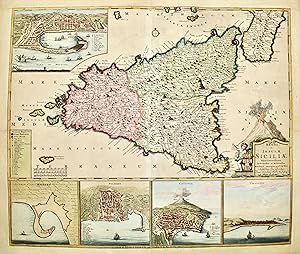
Incisione in rame, dipinta a mano díepoca, mm 495x590. Seconda e pi? rara versione della Sicilia, in cui líisola appare correttamente orientata, in confronto con la prima versione dove appariva con la punta ruotata verso il basso di circa 40? In basso sono posti dei riquadri con le piante di Milazzo, Palermo e Catania e veduta d…i Trapani, in alto vi Ë una veduta di Messina. Tratta da ìAtlas sive Descriptio Terrarum Orbisî. De Wit fu uno dei pi? noti cartografi della seconda met? del ë600, acquistÚ molte lastre da Blaeu e Jansonius producendo molti atlanti. Esemplare con qualche normale ossidazione del tempo, alcuni restauri conservativi a crepe dovute allíossidazione del colore, rifilata alla cornice ma con margini in carta antica aggiunti. Valerio, Spagnolo, "Sicilia 1477-1861, La collezione Spagnolo-Patermo in quattro secoli di cartografia", n? 58 Nr.cat: Cod 5765.
Published by Amsterdam/L'Aia, 1690
- Art / Print / Poster
Seller: libreria antiquaria perini Sas di Perini, Verona, VR, Italylibreria antiquaria perini Sas di Perini
Contact seller5-star sellerCondition: Used
US$ 1,470.53
US$ 45.69 shippingShips from Italy to U.S.A.Quantity: 1 available
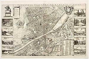
Due fogli incisi in rame uniti, mm 445x360 ogni foglio. Splendida pianta topografica rialzata arricchita da dieci vedutine con scorci principali della citt? Tratta da "Theatrum praecipuarum totius Europae urbium". Ottimo esemplare con le normali tracce di pieghe,visibili solo al verso, leggermente rinforzate da carta cina.Mori-B…offito, p. 63 e p. 70, segnala che l'autore della pianta in origine Ë il pittore incisore di Praga, Wenzel Hollar, che verso il 1660, prese a modello l'incisione di Stefano Bonsignori del 1584. La veduta dell'Hollar viene riedita ad Amsterdam nel 1700 da Frederick de Wit; la stessa lastra si trova anche nell'Historia fiorentina di Giovanni Michele Bruto e nel Thesaurus antiquitatum et historiarum Italiae di Giovanni Giorgio Grevio, Leida 1723. Nr.cat: 3675.

Published by Amsterdam,, 1680
- Art / Print / Poster
Seller: libreria antiquaria perini Sas di Perini, Verona, VR, Italylibreria antiquaria perini Sas di Perini
Contact seller5-star sellerCondition: Used
US$ 1,999.92
US$ 45.69 shippingShips from Italy to U.S.A.Quantity: 1 available
Incisione in rame, stupendamente colorata a mano, di mm 495x590. In basso sono posti dei riquadri con le piante di Messina, Milazzo, Palermo e Catania e veduta di Trapani. Tratta da "Atlas sive Descriptio Terrarum Orbis". De Wit fu uno dei pi? noti cartografi della seconda met? del '600, acquistÚ molte lastre da Blaeu e Jansoniu…s producendo molti atlanti. Esemplare ottimo, con lieve traccia di sporco superficiale all'angolo sinistro superiore. Restauro alla piega centrale, a qualche strappetto e ai bordi della battuta. Buoni i margini.
Published by Amsterdam, 1700
- Art / Print / Poster
Seller: libreria antiquaria perini Sas di Perini, Verona, VR, Italylibreria antiquaria perini Sas di Perini
Contact seller5-star sellerCondition: Used
US$ 1,411.71
US$ 45.69 shippingShips from Italy to U.S.A.Quantity: 1 available
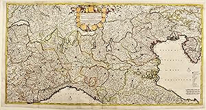
Incisione in rame su due fogli uniti, mm 490x970, colorata. Elegante cartiglio figurato al centro. Questa versione della carta fu pubblicata da De Wit in occasione della guerra di Successione Spagnola, utilizzando le precedenti carte del Dominio veneto e del Piemonte, qui unite, con relative variazioni della lastra nel titolo, a…d alcuni toponimi ed al cartiglio. Tratta da "Atlas sive Descriptio Terrarum Orbis". De Wit fu uno dei pi? noti cartografi della seconda met? del '600; acquistÚ molte lastre da Blaeu e Jansonius, producendo molti atlanti. Ottimo esemplare. Sanfelici-Zanasi. Terre di Langobardia, la "Lombardia", il corso del Po e il Ducato Estense, n. 22. Nr.cat: Cod 3273.

Published by Amsterdam, 1680
- Art / Print / Poster
Seller: libreria antiquaria perini Sas di Perini, Verona, VR, Italylibreria antiquaria perini Sas di Perini
Contact seller5-star sellerCondition: Used
US$ 705.85
US$ 45.69 shippingShips from Italy to U.S.A.Quantity: 1 available
Incisione in rame, dipinta a mano d'epoca, mm 495x575. Decorativa carta di Liguria, Piemonte e Lombardia in splendida coloritura a tutto campo, abbellita da cartiglio con stemmi regionali. De Wit (1629-1706) fu uno dei pi? noti cartografi della seconda met? del '600; nacque a Gouda ma svolse l'attivit? ad Amsterdam dal 1648; dal… 1660 acquistÚ molte lastre da Blaeu e Jansonius, producendo molti atlanti. Alla sua morte le lastre vennero acquistate da Pierre Mortier, che si associÚ poi a Covens formando una delle pi? grandi case cartografiche olandesi del 18? secolo.Copper engraving, original hand colour, mm 495x575. Decorative map of the Republic of Genoa, and Dutchies of Milan, Parma and Montisferrati and contiguous regions. De Wit (1629 ca.-1706) was a mapmaker and mapseller who was born in Gouda but who worked and died in Amsterdam. From the 1660s onward, he published atlases with a variety of maps. After Frederik's death in 1706, most of the plates went to Pieter Mortier, whose firm eventually became Covens & Mortier, one of the biggest cartography houses of the eighteenth century. Nr.cat: Cod 0310.
Published by F. de Wit, Amsterdam, 1690
- Map
Seller: Antiquariat Reinhold Berg eK Inh. R.Berg, Regensburg, GermanyAntiquariat Reinhold Berg eK Inh. R.Berg
Contact seller5-star sellerCondition: Used
US$ 2,294.02
US$ 27.41 shippingShips from Germany to U.S.A.Quantity: 1 available
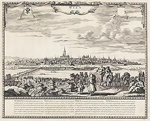
Other. Original copper engraving, uncolored when published. The engraving is shown the view of Vienna. At the top is a cartouche with the german name of the city,Wien'. At the bottom of the map with detailled text descriptions in Dutch, French, German and English. In excellent condition. 405 by 505mm (16 by 20 inches).
Published by Amsterdam, 1680
- Art / Print / Poster
Seller: libreria antiquaria perini Sas di Perini, Verona, VR, Italylibreria antiquaria perini Sas di Perini
Contact seller5-star sellerCondition: Used
US$ 1,058.78
US$ 45.69 shippingShips from Italy to U.S.A.Quantity: 1 available
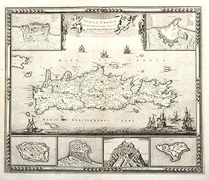
Incisione in rame, mm 470x555, firmata in basso nella cornice "Gedruckt tot Amsterdam by Frederick de Wit inde Kalverstraat inde Witte Paskaert ". Elegante cartiglio figurato al centro. Due riquadri in alto e quattro in basso raffiguranti fortezze e citt? dell'isola: Canea, Candia, Spina Longa, Retimno, Thine e Suda. La carta si… basa su quella di Sebastien de Pontault de Beaulieu, che qualche anno prima eseguÏ numerosei disegni di fortezze del mediterraneo. Tratta da "Atlas sive Descriptio Terrarum Orbis". De Wit fu uno dei pi? noti cartografi della seconda met? del '600; acquistÚ molte lastre da Blaeu e Jansonius, producendo molti atlanti. Splendido esemplare in ottimo stato di conservazione eccettuata una traccia di tarlo nei margini laterali. Map of Crete with six insets showing the fortifications of Canea, Candia Spina Longa, Retimo, Thine and Suda. Based on the cartography of Sebastien de Pontault de Beaulieu, who mapped a lot of Mediterranean fortifications approx. anno 1674. On the map a lot of informations of roads, towns and topography.Copper engraving, mm 470x555. Six insets with plans of Canea/ Chania, Candia/Iralkion, Spina Longa, Retimo, Thine and Suda. decorative banner title held by two cherubs at top and nice bordure. It is based on the cartography of Sebastien de Pontault de Beaulieu, who mapped a lot of Mediterranean fortifications approx. anno 1674. Dark Impression, very good conditio except some minor worming in outer margins. From "Atlas sive Descriptio Terrarum Orbis".De Wit was one of the most prominent and successful map engravers and publishers in Amsterdam in the period following the decline of the Blaeu and Jansson establishments, from which he acquired many copper plates when they were dispersed at auction.His output covered most aspects of map making: sea charts, world atlases, an atlas of the Netherlands, 'town books' covering plans of towns and cities in the Netherlands and Europe, and wall maps.Frederick de Wit was born in Gouda near Amsterdam in 1648 and by 1654 he had opened a printing office and shop under the name "De Drie Crabben" (the Three Crabs) which was also the name of his house on the Kalverstraat. In 1655, De Wit changed the name of his shop to the "Witte Pascaert" (the White Chart). Under this name De Wit and his firm became internationally known.Dating De Wit's atlases and maps is considered difficult because usually no dates were recorded on the maps and their dates of publication extended over many yearsZacharakis:3714/2392.
Published by Amsterdam, 1680
- Art / Print / Poster
Seller: libreria antiquaria perini Sas di Perini, Verona, VR, Italylibreria antiquaria perini Sas di Perini
Contact seller5-star sellerCondition: Used
US$ 1,058.78
US$ 45.69 shippingShips from Italy to U.S.A.Quantity: 1 available
Incisione in rame, finemente colorata a mano d'epoca a tutto campo, mm 500x615. Elegante cartiglio figurato nell'angolo sup. sin. Tratta da "Atlas sive Descriptio Terrarum Orbis". De Wit fu uno dei pi? noti cartografi della seconda met? del '600; acquistÚ molte lastre da Blaeu e Jansonius, producendo molti atlanti. Splendido ese…mplare in ottimo stato di conservazione e splendida coloritura Nr.cat: P2210003.
 More images
Published by Amsterdam, 1675
Seller: Antipodean Books, Maps & Prints, ABAA, Garrison, NY, U.S.A.Antipodean Books, Maps & Prints, ABAA
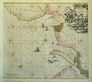
Contact seller4-star sellerHand colored copper plate engraved decorative sea chart of the Russian Arctic, oriented east, from De Wit's 'Orbis Maritimus ofte Zee Atlas'. Original color with the green beautifully toned brown, to confirm original color. Showing Mare Album and Lap Landt at the lower right, and Nova Zemla at the top. With a highly decorative c…artouche at the upper right, with a hunting scene of funny looking polar bears and walrus; compass roses and rhumb lines. The oceans include several sailing ships as well as whaling ships, whaling long boats and two whales. Image size: 22 1/4 x 19 1/2". Paper size: 24 1/2 x 21". Light damp marks at margins, no where near the image, very good condition.
Published by Norimberga,, 1710
- Art / Print / Poster
Seller: libreria antiquaria perini Sas di Perini, Verona, VR, Italylibreria antiquaria perini Sas di Perini
Contact seller5-star sellerCondition: Used
US$ 1,176.42
US$ 45.69 shippingShips from Italy to U.S.A.Quantity: 1 available
Incisione in rame incisa da J. B. Homann pubblicata da David Funck, colorata d'epoca, 495x575. Non comune edizione della carta di De Wit, originariamente stampata ad Amsterdam nel 1680 ca. Copperplate, original colour, 495x575, engraved by J. B. Homann, published by David Funck; an uncommon late edition of the De Wit map, origin…ally published in c.1680. A good example. Nr.cat: 1319.
Published by Amsterdam, 1680
- Art / Print / Poster
Seller: libreria antiquaria perini Sas di Perini, Verona, VR, Italylibreria antiquaria perini Sas di Perini
Contact seller5-star sellerCondition: Used
US$ 3,529.27
US$ 45.69 shippingShips from Italy to U.S.A.Quantity: 1 available
Incisione in rame, dipinta finemente d'epoca a tutto campo, 500x600. Una fra le pi? scenografiche, spettacolari e ricercate carte dell'isola, dominata dalla grande veduta generale di Messina in alto a sinistra, mentre nella fascia inf. vi sono quattro inserti delle citt? di Milazzo, Palermo, Catania e Trapani. Splendido esemplar…e marginoso in splendida coloritura strettamente coeva. Nr.cat: 1743.

- Map
Seller: Geographicus Rare Antique Maps, Brooklyn, NY, U.S.A.Geographicus Rare Antique Maps
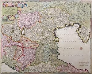
Contact seller4-star sellerGood. Few mended tears with slight impact on image; small ink stain to cartouche. Faint original outline color. Size 19 x 23 Inches. This is a c. 1688 Frederic De Wit map of Hungary and the surrounding region, including parts of modern-day Austria, Slovakia, Croatia, and Serbia. The map was issued at the height of the Great Turk…ish War (1683 - 1699), which ravaged the region, but a string of European victories ended Ottoman expansion into Europe. A Closer Look Spanning from Vienna (top-left) to Belgrade (bottom-right), the Danube River immediately commands this map. Buda and Pest are illustrated, along with numerous other towns and villages along the river and throughout the region. Mountains and trees are illustrated pictorially. The map's detail shows a sharp increase compared to the maps produced by the French and Dutch of the mid-17th century, reflecting the rise in interest in and data from this area during the Great Turkish War. The sharp detail of the south-north route between the rivers Sava Drava and the Danube leading to Vienna is less apparent, for example, on the 1677 Nicolas Visscher map covering this region. That said, De Wit's sources are obscure, a pity, as De Wit's map proved influential, being copied by the younger Visscher and other mapmakers, including Senex. The map is embellished with an allegorical cartouche in the lower right. One putto holds an imperial crown over the arms of the Kingdom of Hungary. To the left of the cartouche, a cheerful putto brandishes a sword and a Cross while treading upon a fallen putto in Turkish garb. This unsubtle, triumphal image likely refers to the 1683 Battle of Vienna, a victory by the Christian coalition over the Turkish Empire. Historical Context: The Great Turkish War The Great Turkish War (1683-1699), also known as the War of the Holy League, was a pivotal conflict between the Ottoman Empire and a coalition of European powers united under the Holy League, formed by the Papacy. The war began after the Ottoman siege of Vienna in 1683, where Ottoman forces, led by Grand Vizier Kara Mustafa, were decisively defeated by a combined army of the Holy Roman Empire, Poland-Lithuania, and other European allies under the command of Polish King John III Sobieski. This defeat marked the turning point of Ottoman expansion into Europe. The war saw a series of major battles across Central and Eastern Europe, involving Austria, Poland, Venice, and Russia against the Ottomans. Key events included the liberation of Hungary and Transylvania from Ottoman rule, as well as the Venetian recapture of parts of the Peloponnese. The conflict culminated in the Treaty of Karlowitz in 1699, which significantly curtailed Ottoman territorial control in Europe. Austria gained Hungary and Transylvania, Poland recovered Podolia, Venice gained territories in Greece and Dalmatia, and Russia secured Azov. The Great Turkish War marked the beginning of the Ottoman Empire's territorial decline and a shift in the balance of power in Eastern Europe, solidifying Habsburg dominance in Central Europe while weakening Ottoman influence in the Balkans. Publication History and Census This map was created for inclusion in Frederick de Wit's Atlas . We see dates for it in institutional collections as early as 1659, but these reflect the dates of the composite atlases in which the map had been inserted, likely much later. Given the content of the map relevant to the early part of the 1680s, we support a date no later than 1688. The map is well represented in institutional collections. References: OCLC 703875416; Rumsey 12220.078 (Estimated 1682).

- Map
Seller: Geographicus Rare Antique Maps, Brooklyn, NY, U.S.A.Geographicus Rare Antique Maps
Contact seller4-star sellerGood. Mended marginal tears and centerfold split at bottom. Size 19 x 22 Inches. This is an unrecorded, likely pirated map based on Frederic De Wit's c. 1680 map of Asia. While cartographically identical to the De Wit, there are enough variations in the engraving to conclude that it was printed from a different plate not referen…ced elsewhere. A Closer Look Coverage embraces from the Eastern Mediterranean in the west to embrace Japan in the east. The Spice Islands appear in detail, including half of New Guinea. Part of northern Australia ( Holandia Nova ) is sketched in at the lower right. Japan and Hokkaido (Yedso) are mapped according to the 1643 discoveries of Dutchmen Maerten de Vries and Cornelis Jansz Coen. Vries and Coen were in search of gold and silver islands supposedly previously discovered by a mysterious Spanish or Portuguese navigator, Juan de Gama. They sailed up the east coast of Japan and continued northward into the bay separating Honsh? from Hokkaido. They skirted the east coast of this bay before discovering Kunashir, here Staten Land, the most westerly of the Japanese Kuril Islands. They also sighted Iturup, also known as Etorofu, the second Kuril Island. This island they only tenuously explored and named Compagnie, after the VOC, their sponsors. Subsequent maps assigned great size to Compagnie on little more than speculation. These islands were not more properly mapped until the explorations of Vitus Bering. Korea appears with minimal detail, but correctly indicated as a peninsula rather than the insular depiction common on maps from the late 16th and early 17th century. Chiamay The apocryphal Lake Chiamay appears just north of the Bay of Bengal as the source of four important Southeast Asian River systems: the Irrawaddy, the Dharla, the Chao Phraya, and the Brahmaputra. The curious Lake Chiamay (also called Chiam-may or Chian-may), roughly located in the area of Assam but sometimes as far north as Tibet and China, began to appear on maps of this region as early as the 16th century and persisted well into the mid-18th century. An Unknown Engraving While adhering cartographically to the c. 1680 De Wit map, the present example contains numerous differences in engraving that distinguish it as a separate plate, possibly from the hand of a different engraver. De Wit's engravers' imprint (which appeared at bottom right of center, under the word 'India') is absent here. The longitude gradations have been rounded up to the nearest ten (for example, where the original numbers are 68, 78, and so on, the present example rounds up to 70, 80, and so on). Between longitude lines, lower-case reference letters in brackets have been included. The present map labels the Equator 'Aequator Siva Linea Aequinoctialis' (sic), where no label appears on the first state. On this map, the place name 'Holandia Nova' has only the single 'l', whereas the 1680 spelling of 'Hollandia' is correct. Most strikingly, the map's title on the cartouche has clearly been printed from a separate plate and exhibits a prominent platemark of its own. This separate plate even appears to have come from yet another copy of the c. 1680 De Wit plate: at its top edge, the remnants of the long tail feathers belonging to the bird engraved atop the plinth can be plainly seen between the words 'Accuratissima totius'. The variations shown - revealing misunderstandings that a cartographer would be less likely to miss than an engraver - suggest to us that this work is a pirated version of the map by a working engraver, rather than an actual De Wit edition. Publication History and Census This map was engraved by an unknown engraver at some point after 1689. We see no catalog entries for it and no sales records. Richard Betz, in his The Mapping Of Africa , identifies a single map after De Wit's 1680 map of Africa exhibiting similar alterations to the longitude lines as here, albeit without the reference letters evident here. References: Not in OCLC. Compare with OC.

Seller: Vangsgaards Antikvariat Aps, Copenhagen, DenmarkVangsgaards Antikvariat Aps
Contact seller5-star sellerCondition: Used
US$ 1,573.72
US$ 33.63 shippingShips from Denmark to U.S.A.Quantity: 1 available
Kobberstukket prospekt af København set fra Christianshavn. Udgivet af Frederic de Wit, Amsterdam c. 1670. Med versificeret tekst på nederlandsk, fransk, tysk og engelsk. Lysmål, inkl. tekst: 39 x 52 cm. Med pladerande og brede margener. Motivet lidt mørknet. Indrammet i smuk guldlakeret ramme fra c. 1850. * Meget dekorativt pro…spekt af København set fra Amager. Grundlaget er Jan van Wijks store malede prospekt af byen fra 1610, som kendes i et eneste bevaret kobberstik, men var internationalt udbredt i første halvdel af 1600-tallet. Maleriet brændte på Københavns Rådhus i 1728. Motivet er dog her opdateret, så Børsen og den nordligste ende af Christianshavn er kommet med. Holmens Kirke fremtræder dog stadig som Bremerholms ankersmedie. I havnen ses hollandske og engelske skibe, som de så ud på stikkets udførelsestidspunkt. I forgrunden er vist en stor gruppe dragoner, som minder om, at Svenskekrigene og belejringen var i frisk erindring. Øverst på billedet optræder det danske rigsvåben og Københavns våben.


