Fricx (38 results)

- Softcover
Seller: PBShop.store UK, Fairford, GLOS, United KingdomPBShop.store UK
Contact seller5-star sellerCondition: New
US$ 24.43
US$ 5.56 shippingShips from United Kingdom to U.S.A.Quantity: 15 available
PAP. Condition: New. New Book. Shipped from UK. Established seller since 2000.

- Softcover
Seller: Revaluation Books, Exeter, , United KingdomRevaluation Books
Contact seller5-star sellerCondition: New
US$ 18.56
US$ 13.36 shippingShips from United Kingdom to U.S.A.Quantity: 1 available
Paperback. Condition: Brand New. 138 pages. French language. 8.90x6.02x0.43 inches. In Stock.

- Softcover
- Print on Demand
Seller: Forgotten Books, London, United KingdomForgotten Books
Contact seller4-star sellerCondition: New
US$ 26.51
Free ShippingShips from United Kingdom to U.S.A.Quantity: Over 20 available
Paperback. Condition: New. Print on Demand. This book is a profound and multifaceted exploration of what it means to be truly human. Set against the backdrop of a turbulent political landscape, the author delves into the complex interplay between our genetic inheritance, personal choices, and the social forces that shape our liv…es. The book offers a thought-provoking examination of the ethical dilemmas we face as individuals and as a society, shedding light on the complexities of human nature and the search for meaning in an ever-changing world. Through its insightful analysis and compelling narratives, this book challenges readers to reflect on their own values and responsibilities, and to engage in meaningful dialogue about the future of humanity. This book is a reproduction of an important historical work, digitally reconstructed using state-of-the-art technology to preserve the original format. In rare cases, an imperfection in the original, such as a blemish or missing page, may be replicated in the book. print-on-demand item.

- Softcover
Seller: moluna, Greven, , Germanymoluna
Contact seller5-star sellerCondition: New
US$ 30.20
US$ 56.51 shippingShips from Germany to U.S.A.Quantity: Over 20 available
Condition: New. KlappentextrnrnThis is a reproduction of the original artefact. Generally these books are created from careful scans of the original. This allows us to preserve the book accurately and present it in the way the author intended. Since the origina.

Published by Fricx/Friex E.H., 1644-1730 1730
- Hardcover
Seller: Hammelburger Antiquariat, Hammelburg, , GermanyHammelburger Antiquariat
Contact seller5-star sellerCondition: Used - Very good
US$ 105.74
US$ 34.61 shippingShips from Germany to U.S.A.Quantity: 1 available
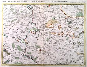
Hardcover. Condition: very good. Noord West-Vlaanderen, Bruges, anno 1712, map-Fricx Antique map of Noord West-Vlaanderen by Fricx E. Carte particulière des environs de Bruges, Ostende, Damme, L'Ecluse et Autres. - Fricx E. ,1712. This map covers the region of Northern West-Vlaanderen with the cities of Brugge (Bruges), Oostende…, Knokke, Damme and Sluis. Copper engraving Size: 42 x 56cm. Verso: Blank Condition: printed on thick opaper, little brownish, some small tears on margins. From: Table des cartes des Pays Bas et des Frontières de France, Avec un recueil des plans des villes, sièges et battailles données entre les Hauts Alliés et la France. Bruxelles, H. Fricx, 1712.
Published by Fricx/Friex E.H., 1644-1730 1730
- Hardcover
Seller: Hammelburger Antiquariat, Hammelburg, , GermanyHammelburger Antiquariat
Contact seller5-star sellerCondition: Used - Very good
US$ 106.93
US$ 34.61 shippingShips from Germany to U.S.A.Quantity: 1 available
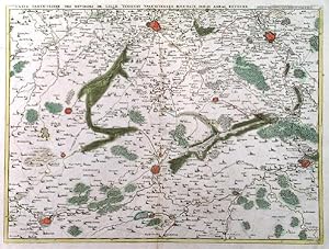
Hardcover. Condition: very good. Carte Lille/Tournay/Valenciennes/Bouchain, anno 1712, Fricx, size of the leaf: 52x62 cm., little brwonish, some small tears on margins.

Published by Fricx/Friex E.H., 1644-1730 1730
- Hardcover
Seller: Hammelburger Antiquariat, Hammelburg, , GermanyHammelburger Antiquariat
Contact seller5-star sellerCondition: Used - Very good
US$ 141.39
US$ 34.61 shippingShips from Germany to U.S.A.Quantity: 1 available
Hardcover. Condition: very good. Dunkerque, Bergues, Furnes, Calais, anno 1712, Fricx map Description: Carte Particuliere des Environs de Dunkerque, Bergues, Furnes (Veurne), Gravelines, Calais, et Autres France Eugene Henri Fricx 1712. A Handsome map of the coast from Calais to Furnes and into the interior as far as Cassel. Gre…at detail of roads, forests, canals and fortified cities. The map is decorated with several sailing ships and fishing boats. Size of the leaf: 52x62 cm. Condition: some small tears on margins, little brownish.

- Hardcover
- Print on Demand
Seller: True World of Books, Delhi, , IndiaTrue World of Books
Contact seller5-star sellerLeatherBound. Condition: New. BOOKS ARE EXEMPT FROM IMPORT DUTIES AND TARIFFS; NO EXTRA CHARGES APPLY. Leather Binding on Spine and Corners with Golden leaf printing on spine. Bound in genuine leather with Satin ribbon page markers and Spine with raised gilt bands. A perfect gift for your loved ones. Reprinted from 1736 edition.… NO changes have been made to the original text. This is NOT a retyped or an ocr'd reprint. Illustrations, Index, if any, are included in black and white. Each page is checked manually before printing. As this print on demand book is reprinted from a very old book, there could be some missing or flawed pages, but we always try to make the book as complete as possible. Fold-outs, if any, are not part of the book. If the original book was published in multiple volumes then this reprint is of only one volume, not the whole set and contains approximately 24 pages. IF YOU WISH TO ORDER PARTICULAR VOLUME OR ALL THE VOLUMES YOU CAN CONTACT US. Resized as per current standards. Sewing binding for longer life, where the book block is actually sewn (smythe sewn/section sewn) with thread before binding which results in a more durable type of binding. Language: French.

Published by Eugene Henry Fricx 1709 1709
- Map
Seller: Garwood & Voigt, Sevenoaks, United KingdomGarwood & Voigt
Contact seller5-star sellerCondition: Used - Fine
US$ 103.22
US$ 40.09 shippingShips from United Kingdom to U.S.A.Quantity: 1 available
Condition: Fine. 41x56cm. Original outline colour. Excellent condition.
Published by Eugene Henry Fricx 1708 1708
- Map
Seller: Garwood & Voigt, Sevenoaks, United KingdomGarwood & Voigt
Contact seller5-star sellerCondition: Used - Fine
US$ 137.63
US$ 40.09 shippingShips from United Kingdom to U.S.A.Quantity: 1 available
Condition: Fine. 41x55cm. Original outline colour. Excellent condition.
Published by Eugene Henry Fricx ca. 1706 1706
- Map
Seller: Garwood & Voigt, Sevenoaks, United KingdomGarwood & Voigt
Contact seller5-star sellerCondition: Used - Fine
US$ 137.63
US$ 40.09 shippingShips from United Kingdom to U.S.A.Quantity: 1 available
Condition: Fine. 40x55cm. Original outline colour. Excellent condition.
Published by Eugene Henry Fricx 1708 1708
- Map
Seller: Garwood & Voigt, Sevenoaks, United KingdomGarwood & Voigt
Contact seller5-star sellerCondition: Used - Fine
US$ 137.63
US$ 40.09 shippingShips from United Kingdom to U.S.A.Quantity: 1 available
Condition: Fine. 42x56cm. Original outline colour. Excellent condition.
Published by Eugene Henry Fricx 1706 1706
- Map
Seller: Garwood & Voigt, Sevenoaks, United KingdomGarwood & Voigt
Contact seller5-star sellerCondition: Used - Fine
US$ 137.63
US$ 40.09 shippingShips from United Kingdom to U.S.A.Quantity: 1 available
Condition: Fine. 41x55cm. Original outline colour. Excellent condition.
- Hardcover
Seller: Frans Melk Antiquariaat, HILVERSUM, NetherlandsFrans Melk Antiquariaat
Contact seller5-star sellerCondition: Used
US$ 118.81
US$ 78.44 shippingShips from Netherlands to U.S.A.Quantity: 1 available
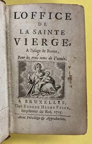
Bruxelles chez Eugene Henry Fricx, 1715. 11 x 6,5 cm. Bound in leather. Hardcover. Edges gilt. 403 pages. Very Acceptable Copy [Theologie / Theology [Theologie / Kerkgeschiedenis] ].

Published by Brussels 1712
- Map
Seller: Clive A. Burden Ltd., Chalfont St. Giles, BUCKS, United KingdomClive A. Burden Ltd.
Contact seller5-star sellerCondition: Used
US$ 240.84
US$ 29.60 shippingShips from United Kingdom to U.S.A.Quantity: 1 available
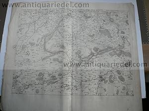
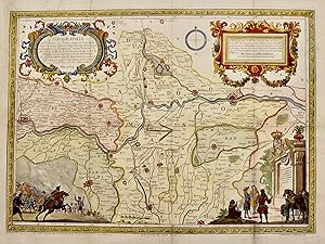
No binding. 420 x 560 mm., backed on linen and folded, but not cut. Eugene Henri Fricx (1644-1730) is best known for his maps of the military campaigns of the War of the Spanish Succession 1701-14. He was a bookseller and publisher in Brussels. One sheet of a 24 sheet map "Table des cartes des Pays Bas et des Frontieres de Franc…e". A rare map of Kent. Engraved by Harrewyn. Tooley's Dictionary of Mapmakers. Koeman II pp. 109-10.
 More images
Published by Fricx, Eugene Henri, Brussels 1707
Seller: poor man's rare books (mrbooks) IOBA NJB, Vineland, NJ, U.S.A.poor man's rare books (mrbooks) IOBA NJB
Contact seller3-star sellerMap. Condition: Very Good with no dust jacket. Belgium; We fit archival quality clear acrylic covers for additional protection whenever possible. ; Color Illustrations; 1 piece. Hand-Colored Engraved Town Plan. Fricx, Eugene Henri. "Plan de la Ville Dostende." Brussels, 1707. Approx. 20 x 28 1/2 inches (508 x 724 mm) ; scattered… light foxing, mat mounted on edges of map, tape repairs on verso.

Published by Paris. 1743 1743
Seller: Peter Harrington. ABA/ ILAB., London, United KingdomPeter Harrington. ABA/ ILAB.
Contact seller5-star sellerCondition: Used
US$ 302.78
US$ 29.40 shippingShips from United Kingdom to U.S.A.Quantity: 1 available
Fricx's famous maps of Belgium and northern France, accurate and detailed, show the fortifications of the towns very clearly, here boldly coloured in red. Originally published in 1712. Atlas Militaire. Copper engraving. Fine condition, good margins. Original colour. Size: 64.3 x 48.5 cm.

Published by Paris. 1744 1744
Seller: Peter Harrington. ABA/ ILAB., London, United KingdomPeter Harrington. ABA/ ILAB.
Contact seller5-star sellerCondition: Used
US$ 378.47
US$ 29.40 shippingShips from United Kingdom to U.S.A.Quantity: 1 available
Fricx's famous maps of Belgium and northern France, accurate and detailed, show the fortifications of the towns very clearly, here boldly coloured in red. Originally published in 1712 in the Atlas Militaire. Copper engraving. Good condition. Tear at top left corner, some loss to margin, not affecting map Later colouring. Size: 6…5 x 49 cm.

Published by Bruxelles, Eugène Henrÿ FRICX, 1709 1709
Seller: Librairie Historique F. Teissèdre, SAUVE, FranceLibrairie Historique F. Teissèdre
Contact seller5-star sellerCondition: Used
US$ 356.44
US$ 51.91 shippingShips from France to U.S.A.Quantity: 1 available
sans les marges : 42 x 54 cm - cadre : 60.5 x 70.5 cm, cadre contemporain à baguettes. Pliure centrale. Quelques taches. Beau plan gravé figurant la citadelle de Lille, oeuvre de Vauban et de son profil par Eugène Henry Fricx d'après les dessins du capitaine Brüchman. Titre dans un cartouche ornementé : Armoiries du prince Eugèn…e de Savoie entourées de figures allégoriques : "Présenté à S.A.S. Monseigneur le Prince Eugène de Savoye. par son res.humble serviteur et tres.obeissant Eugène Henry Fricx/Plan de la citadelle de Lille./ Laquelle, après que la Ville fut prise le 22 octobre, on a aussi commencé d'attaquer sous le commandement de S.A. le Prince Eugène de Savoye dès le 29 et ainsi continué, comme il se voit par les renvoys suivans, jusques au 8 Décembre 1708 lorsque l'ennemi battit la chamade à 8 heures du matin, et en sortit trois jours après tambour batant et enseignes déployées. Le tout dessiné et levé avec la dernière exactitude pendant et après le siège, avec les attaques et la force des ouvrages représentés en Profil par le Sueur Brüchman Capitaine de S.A.E. de Bruns: Luneb: et Hanovre [.]A BRUXELLES. Chez Eugène Henrÿ Fricx rue de la madeleine. 1709. Echelle de 200 toises pour la citadelle. Echelle de 20 toises pour le profil."Eugène Henri Fricx (1644-1730) Imprimeur-libraire belge, imprimeur du Roi (1689) et de Sa Majesté Impériale et Catholique (1715)Édifiée sur ordre de Louis XIV à sa conquête de la ville, la Citadelle de Lille a été édifiée entre 1667 et 1670 par Sébastien Le Prestre, marquis de Vauban (1633-1707) - - VENTE PAR CORRESPONDANCE UNIQUEMENT - LIEN DE PAIEMENT, NOUS CONSULTER.

Published by Atlas Militaire. 1743 1743
Seller: Peter Harrington. ABA/ ILAB., London, United KingdomPeter Harrington. ABA/ ILAB.
Contact seller5-star sellerCondition: Used
US$ 412.88
US$ 29.40 shippingShips from United Kingdom to U.S.A.Quantity: 1 available
Fricx's famous maps of Belgium and northern France, accurate and detailed, show the fortifications of the towns very clearly, here boldly coloured in red. Originally published in 1712 Copper engraving. Fine condition, good margins. Original colour. Size: 64.3 x 48.5 cm. (25½ x 19 inches).
 More images
Published by Fricx/Friex E.H., 1644-1730 1720
- Map
Seller: Hammelburger Antiquariat, Hammelburg, , GermanyHammelburger Antiquariat
Contact seller5-star sellerCondition: Used - Very good
US$ 414.65
US$ 34.61 shippingShips from Germany to U.S.A.Quantity: 1 available
Kein Einband. Condition: Gut. St.Venant-Plan, Capture of 1710, 2 maps, Fricx, anno 1720. Two copperengravings of the siege and capture of the duke of Nassau in the year 1710. 2 very good prints, wide margins, thick paper. Size of the leaves: 55x62 and 55x31 cm. Plate size: 41x48 and 41x24 cm. St. Venant. Assiege & pris en 1710 p…ar le Pr. d'Orange. Der Ort St. Venant in Nordfrankreich wurde im Spanischen Erbfolgekrieg vom Fürsten von Nassau Johann Wilhelm Friso (Prince d'Orange) eingenommen.

Published by Artist: Fricx Henry ( - 1730 ) Brussels dated : 1709 1680
Seller: Antique Sommer& Sapunaru KG, München, , GermanyAntique Sommer& Sapunaru KG
Contact seller4-star sellerCondition: Used
US$ 522.77
US$ 51.91 shippingShips from Germany to U.S.A.Quantity: 1 available
Technic: Copper print, colorit: original colored, condition: Perfect condition, size (in cm): 37 x 48 cm, Decorative map shows the citymap of Valencienne near Belgium.

Published by Artist: Fricx Henry ( - 1730 ) Brussels dated : 1709 1680
Seller: Antique Sommer& Sapunaru KG, München, , GermanyAntique Sommer& Sapunaru KG
Contact seller4-star sellerCondition: Used
US$ 629.70
US$ 51.91 shippingShips from Germany to U.S.A.Quantity: 1 available
Technic: Copper print, colorit: original colored, condition: Some stains according to the age, size (in cm): 44 x 56 cm, Map depicts the coast of Bologne-sur-mer with dea city map, decorative offshore ships and a big windrose. From the atlas: Kaart van de Franse kust bij Boulogne en Picardië, 1709. Printed from Harrewijn, Jacobu…s.

Published by Artist: Fricx Eugène-Henri ( - 1730 ) Bruxelles ca : 1704 1644
- Art Print
Seller: Antique Sommer& Sapunaru KG, München, , GermanyAntique Sommer& Sapunaru KG
Contact seller4-star sellerCondition: Used
US$ 629.70
US$ 51.91 shippingShips from Germany to U.S.A.Quantity: 1 available
Technic: Copper print, colorit: colored, condition: Some folds, tears perfectly set down, size (in cm): 43 x 59,5 cm, Representation of the disembarkment of the french king at Naples caused by the The War of the Spanish Succession (1702?1715). It was a major European conflict of the early 18th century, triggered by the death in…1700 of the last Habsburg King of Spain, the infirm and childless Charles II. In 1702 the war in northern Italy was in its second year. After Austria's initial success Louis XIV sent Marshal Vendôme to command the Bourbon army, and with greatly superior numbers he began to dominate and pin back his opponent. With the Duke of Savoy's desertion Piedmont-Savoy became an important goal for the French, who now aimed to isolate Victor Amadeus and Starhemberg from the Austrians to the east and secure communications between France and Milan. By the beginning of 1704 Marshal Tessé had taken the Duchy of Savoy.
 More images
- Hardcover
- First Edition
Seller: Herman H. J. Lynge & Søn ILAB-ABF, Copenhagen, , DenmarkHerman H. J. Lynge & Søn ILAB-ABF
Contact seller4-star sellerCondition: Used
US$ 4,450.79
Free ShippingShips from Denmark to U.S.A.Quantity: 1 available
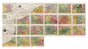
Brussels, 1712. Folio (512 x 315 mm). In contemporary half calf with seven raised bands. Spine and hindges with wear. Leather brittle and upper and lower 10 cm hindges detached. Two library labels pasted on to pasted down front end-paper. Upper margin of first three leaves blind-stamped. Handwritten (19th century hand) index mou…nted in on verso of first map and each map numbered. With 75 maps and plans, many double-page or folding: 24 cartes des Pays Bas, Carte générale de Brabant, Carte du Pays de Waes, Carte des Postes d'Allemagne, 48 plans des Villes, Sièges & Batailles (complete). 3 maps with minor marginal tear (outside plate), 2 with minor split to lower part of middle folding. A few maps at end with browning. A few plates (primarily 61, 50, 33, 25) heavily trimmed with slight loss to upper margin. An overall fine and clean copy. First edition of Fricx?s famous atlas consisting of topographical maps, plans of towns, fortresses, sieges and battlefields. Today Fricx is considered one of the most important map publishers in the Southern Netherlands in the 18th century. This collection of maps and plans of fortifications is also known under the title ?Recueil des cartes des provinces meridionales des Pays Bas et des frontiers de la France. The first 24 maps form together a topographical maps of the Southern Netherlands, scale 1:115.000. Most of the plates were engraved by Jacob Harrewijn. These maps were based on military maps by French engineers and show an accurate representation of the topography. The importance of the map of the Spanish Netherlands is demonstrated by the fact that the 24 sheets were copied in Paris, Augsburg, and Amsterdam. The maps were also published separately. ?The bookseller and printer, Eugéne Henri Fricx, was one of the most important map publishers of the Southern Netherlands in the 18th century. He lived in Brussels where he had his shop on Rue de la Madeleine. His activities in the field started in 1706 with the production of military plans of battles and sieges of the War of Succession. In the same year,he also stated the publication of the map of the Southern Netherlands in 24 sheets it was finished in 1712, apart from the sheet Luxemborg, which was engraved in 1727. He employed Jean Harrewijn of Brussels as an engraver and Cornelis Marke of Middelburg as a contractor for the ?enluminators? Although he had children, his business was not continued after his death (about 1740). His map of the Southern Netherlands was copied by Covens & Mortier and sold until ca. 1780, when it was replaced by Ferraris? Map of the Austrian Netherlands.? (Koeman II, Fri1) Koeman II, Fri1.

- Softcover
Seller: Antiquariaat A. Kok & Zn. B.V., Amsterdam, , NetherlandsAntiquariaat A. Kok & Zn. B.V.
Contact seller5-star sellerCondition: Used
US$ 1,633.67
US$ 32.61 shippingShips from Netherlands to U.S.A.Quantity: 1 available
Paris, Crepy, 1744. Large decorative copper-engraved wall-map of Belgium (total size when joined: 141 x 310 cm) still on 15 bound folded unjoined sheets (as published). Including a large plan of Lille (not intended to be part of the map) Bound in early 20 century limp wrappers. Folio. - Binding seriously worn; first maps slightl…y frayed in the lower-margins, some waterstains affecting the upper-margins.
Published by Paris, chez [Etienne Louis] Crépy 1744. 1744
Seller: Buch + Kunst + hommagerie Sabine Koitka, Basel, , SwitzerlandBuch + Kunst + hommagerie Sabine Koitka
Contact seller4-star sellerCondition: Used
US$ 5,793.50
US$ 16.73 shippingShips from Switzerland to U.S.A.Quantity: 1 available
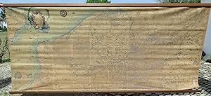
15 doppelblattgrosse Einzelkartenblätter in Kupferstich (je ca. 47x65 cm). Titelblatt mit Kartusche sowie die Wasserflächen mit Schiffstaffage koloriert. Alle Kartenblätter zur grossen Wandkarte zusammengefügt und auf Leinen montiert (ca. 1,43x3,23 m). Auf 2 Holzstäben aufgerollt. Koloriertes und zu einer einzigen, sehr grossen,… Wandkarte auf Leinen montiertes Exemplar der von Etienne Louis Crépy auf fünfzehn doppelblattgrossen Kartenblättern in Kupferstich gedruckten Neuausgabe von Eugène Henri Fricx? (oder Frickx) berühmter Generalkarte der Spanisch/Oesterreichischen Niederlande. - Der in Brüssel wirkende Eugène Henri Fricx (1644-1730) hatte sie unter dem Titel ?Table des Cartes des Pays Bas et des Frontieres de France? aufgrund diverser französischen Karten kompiliert und zuerst 1706-1712, respektive 1727 in 24 Kartenblättern veröffentlicht (das 24. und letzte Blatt erschien tatsächlich erst fünfzehn Jahre nach den vorausgegangenen ersten 23 Karten [siehe Wouter Bracke]). Crépys Pariser Druck weist Veränderungen gegenüber der Erstausgabe aus: ?Le découpage de la carte est différent de celui de l?édition originale, puisque l?édition de Crépy s?étend sur 80 % du territoire belge et inclut des parties du nord de la France? (Nationaal Geografisch Instituut, Bruxelles). - Ganz der Intention von Herausgeber und Verlag folgend, wurden hier alle fünfzehn Karten-blätter zur eindrucksvollen grossen Wandkarte (1,43 x 3,23 m) vereinigt. Die Kolorierung der Kartusche, der Wasserflächen in Blau und der Wälder in Grün [letztere sehr stark verblasst] wurde wohl etwas später ausgeführt). ? Etwas bestaubt, vereinzelte kleinere Fehlstellen. - Koeman, Atlantes neerlandici, Bd. II, S. 110, Fri 2 A; Kat. Inentaris der Kaarten en Globes, Rijksuniversiteit te Ghent (1967), Nr. 425; Klöti, Sammlung Ryhiner, Bd. I (2003), Nr. 4332 ; W. Bracke, Maps by Fricx, in : Brussels International Map Collectors? Circle BIMCC, Newsletter 24, Jan. 2006, S. 14-18. - Spezielle Transportkosten dieses aussergewöhnlich grossen Objekts auf Anfrage. Lang fr.
[Carte du Theatre de la Guerre aux Pais-Bas].
MORTIER, Pieter (1661-1711) - FRICX, Eugene Henri (1644-1730).
Published by Amsterdam: Chez Pierre Mortier, [1710-1711]. 1711
- Signed
Seller: Arader Galleries - AraderNYC, New York, NY, U.S.A.Arader Galleries - AraderNYC
Contact seller5-star sellerSPECTACULAR MAP OF THE SOUTHERN NETHERLANDS AND NORTHERN FRANCE. 21 double-page engraved map sheets numbered in the engraving 1-21 (each ca. 21 x 24 4/8 inches; 16 2/8 x 22 inches to the neat line; with full margins, showing the plate-mark). Each with EXCEPTIONALLY FINE ORIGINAL HAND-COLOUR IN FULL, with territories shown in dif…ferent bold watercolours of pink, green and yellow, the towns and parishes noted, and the important cities shown in red and HEIGHTENED WITH LIQUID GOLD, the coastline delineated in extraordinary detail with sandbanks shown and the Channel teeming with English, Dutch and French galleons, fishing trawlers and other sail boats, decorated with SUPERB WIND AND COMPASS ROSES, HEIGHTENED WITH LIQUID GOLD, and surrounded by a border of yellow wash (old central vertical creases). [WITH:] Carte d'Artois et des Environs; ou l'on voit le Ressort du Conseil Provincial d'Artois: Dresse sur les Observations de M.rs de L'Academie des Sciences. Par G. de l'Isle. Amsterdam: Chez Pierre Mortier. (21 x 24 4/8 inches; 19 2/8 x 24 inches to the neat line; with full margins, showing the plate-mark). A very fine and detailed map of the southern Netherlands and northern France, with EXCEPTIONALLY FINE ORIGINAL HAND-COLOUR IN FULL, with territories shown in different bold watercolours of pink, green and yellow, the towns and parishes noted, and the important cities shown in red and HEIGHTENED WITH LIQUID GOLD, the title within a banner across the top of the map, and within a large and extravagant allegorical cartouche, upper right, HEIGHTENED WITH LIQUID GOLD, decorated with a fine compass rose HEIGHTENED WITH LIQUID GOLD, and surrounded by a border of yellow wash, with the BATTLE LINES DRAWN AND ANNOTATED IN LIQUID GOLD, and dated between 1705 and 1711, CLEARLY SERVING AS A KEY-MAP. Provenance: each map with an additional contemporary manuscript number in the top right-hand corner of the margin; 11 of the maps with the BATTLE LINES DRAWN AND ANNOTATED IN LIQUID GOLD, and dated between 1704 and 1711. A BEAUTIFUL EXAMPLE OF THIS RARE, IMPORTANT AND LARGE-SCALE MAP, WHICH IF JOINED WOULD MAKE A SUPERB WALL MAP OF THE FIELD OF BATTLE FOR THE WAR OF SPANISH SUCCESSION (1701-1714) IN THAT PART OF EUROPE, AND IS ALL THAT WAS PUBLISHED OF THE SERIES BY PIETER MORTIER BEFORE HIS DEATH IN 1711, originally published by Eugene Henri Fricx between 1706 and 1712, in two parts: the first 23 maps forming a large topographical map of the southern Netherlands, as here, followed by 3 general maps and then 47 maps or plans of towns, sieges or battles. The current example is Mortier's version of the first part of Fricx's atlas, copied, improved and augmented by the celebrated Amsterdam cartographical publisher, up to and including the maps issued by Fricx to 1710-1711, eleven maps are illuminated with BATTLE LINES DRAWN AND ANNOTATED IN LIQUID GOLD, and dated between 1704 and 1711, on the first map Carte Particuliere d'une Partie d'Angleterre, Mortier states that his map IS COMPLETE IN 18 SHEETS "Cette Carte Contient 18 fuilles", so, published before a further three maps: "Carte Particuliere des environs d'Avesnes, Landrecy, La Capelle, Guise.", 1712, "Carte Particuliere des environs de Philleville, Charlemont, Marienbiurg, Rocroy.", 1712, and a third map, which might have been a key-map of the "Theatre de la guerre", published as early as 1703, but here replaced by the Carte d'Artois et des Environs; ou l'on voit le Ressort du Conseil Provincial d'Artois: Dresse sur les Observations de M.rs de L'Academied des Sciences. Par G. de l'Isle. Amsterdam: Chez Pierre Mortier, a very fine and detailed map of the southern Netherlands and northern France, with the BATTLE LINES DRAWN AND ANNOTATED IN LIQUID GOLD, and dated between 1705 and 1711. The War of Spanish Succession (17011714) was fought between the major European powers, including a divided Spain, over who had the right to succeed Charles II as King of Spain. That conflict spread to include Amer. Signed by Author(s).
Published by Madrid 1703
- Art Print
Seller: libreria antiquaria perini Sas di Perini, Verona, VR, Italylibreria antiquaria perini Sas di Perini
Contact seller5-star sellerCondition: Used
US$ 1,544.56
US$ 46.14 shippingShips from Italy to U.S.A.Quantity: 1 available
Incisione in rame eseguita a Bruxelles su disegno di Phelipe Palota, colorata, 435x600. Ricercata carta, tratta da "Succession de el Rey Phelipe V" di Antonio de Ubilla y Medina pubblicata nel 1704. Raffigura il teatro della guerra di Successione spagnola, arricchita da eleganti cartigli e scene. Usuali tracce di pieghe con mini…mi restauri nei punti di incrocio, ampio strappo restaurato all'angolo sup. sin. Nr.cat: Cod 2790.
- Hardcover
- Print on Demand
Seller: True World of Books, Delhi, , IndiaTrue World of Books
Contact seller5-star sellerLeatherBound. Condition: New. BOOKS ARE EXEMPT FROM IMPORT DUTIES AND TARIFFS; NO EXTRA CHARGES APPLY. LeatherBound edition. Condition: New. Reprinted from 1703 edition. Leather Binding on Spine and Corners with Golden leaf printing on spine. NO changes have been made to the original text. This is NOT a retyped or an ocr'd repri…nt. Illustrations, Index, if any, are included in black and white. Each page is checked manually before printing. Pages: 460 As this print on demand book is reprinted from a very old book, there could be some missing or flawed pages, but we always try to make the book as complete as possible. Fold-outs, if any, are not part of the book. If the original book was published in multiple volumes then this reprint is of only one volume, not the whole set. Sewing binding for longer life, where the book block is actually sewn (smythe sewn/section sewn) with thread before binding which results in a more durable type of binding. Pages: 460 Language: French.


