

Order Total (1 Item Items):
Shipping Destination:

Gendron Pedro (15 results)
Skip to main search results
Search filters
Product Type
- All Product Types
- Books (7)
- Magazines & Periodicals (No further results match this refinement)
- Comics (No further results match this refinement)
- Sheet Music (No further results match this refinement)
- Art, Prints & Posters (2)
- Photographs (No further results match this refinement)
- Maps (6)
- Manuscripts & Paper Collectibles (No further results match this refinement)
Condition Learn more
- New (No further results match this refinement)
- As New, Fine or Near Fine (No further results match this refinement)
- Very Good or Good (3)
- Fair or Poor (No further results match this refinement)
- As Described (12)
Binding
- All Bindings
- Hardcover (2)
- Softcover (No further results match this refinement)
Collectible Attributes
- First Edition (2)
- Signed (No further results match this refinement)
- Dust Jacket (No further results match this refinement)
- Seller-Supplied Images (13)
- Not Print on Demand (15)
Language (3)
Free Shipping
- Free Shipping to U.S.A. (No further results match this refinement)
Seller Location
Seller Rating
-

1972, Madrid, Granada, Extraido Original Al-Andalus Revista Estudios Arabes, Consejo Superior Investigaciones Cientificas, 50 paginas, 23x15, nuevas cubiertas en rustica sin impresion, buen estado.
-
El 'Señor del Zoco' en España: Edades media y moderna, Contribucion al Estudio de la Historia del Mercado.
Language: Spanish
Published by Madrid: Instituto Hispano-Arabe de Cultura, 1973
ISBN 10: 8460058980 ISBN 13: 9788460058984
Seller: Plurabelle Books Ltd, Cambridge, United Kingdom
Association Member: GIAQ
Seller rating 5 out of 5 stars

First Edition
US$ 168.68
US$ 10.57 shipping
Ships from United Kingdom to U.S.A.Quantity: 1 available
Add to basketHardback. Condition: Very Good. lxix 761p large format hardback, library rebound in plain red cloth with white lettering to spine, with a long preface by Maxine Rodinson, a clean and tight copy, a heavy tome with maps, tables, bibliography and index Language: Spanish.
-
Excerpt from Atlas o Compendio Geografico del Globo terrestre dividido. (7 maps with text pages)
Published by Madrid., 1756
Seller: Zephyr Books LLC, Reno, NV, U.S.A.
Association Member: ABAA ILAB IOBA
Seller rating 5 out of 5 stars
First Edition
1st Edition. Spanish text. Very scarce with the famous Vaugondy maps in Spanish. Engraved explanatory text pages. Maps are hand-colored in outline. Lacks the title page. Includes a full-page colored map legend - Carta General del Mundo - La Europa - El Africa - El Asia - La America Meridional -La America Septentrional - Reynos de Espana y Portugal. weight: 0.7 lb. Good, light wear to corners and spine ends, moderate foxing and marginal soiling, light worm damage to left margin. Seven full-page maps, one folding. 21.8x28x1 cm. [10] leaves text. Hardcover. Later quarter black cloth over marbled boards.
-

El 'Senor Del Zoco' en Espana: Edades media y moderna, Contribucion al Estudio de la Historia del Mercado. Pref.: M.Rodinson.
Published by Madrid: Instituto Hispano-Arabe de Cultura, 1973
Seller: Antiquariat Bergische Bücherstube Mewes, Overath, Germany
Association Member: GIAQ ILAB VDA
Seller rating 5 out of 5 stars
LXIX, 761 S. Lit.verz. Reg. Ln.mS. Sprache: Spanisch.
-
El "señor del zoco" en España: Edades Media y Moderna. Contribución al estudio de la historia del mercado.
Published by Instituto Hispano-árabe de Cultura,, Madrid, 1973
Seller: Salvador Cortés, Librero Anticuario, San Lorenzo del Escorial, M, Spain
Association Member: AILA ILAB LANCE
Seller rating 5 out of 5 stars
lxix+761 pp., planos. 4º tela editorial con sobrecubierta. Muy buen estado, aunque la siobrecubierta con desperfectos marginales. Firma del antiguo propietario.
-

Les Isles Britanniques ou sont le Royaume d'Angleterre. le Royaume d'Ecosse. le Royaume d'Irlande.
Published by Londres (Madrid?) 1760 ca., 1760
Seller: Libreria Ex Libris ALAI-ILAB/LILA member, Roma, RM, Italy
Seller rating 5 out of 5 stars
Map
Incisione originale su rame (cm. 74x54 più margini bianchi). Coloritura coeva all'acquerello. Alcuni piccole lievi macchie, ma ottimo esemplare. Rara.
-

El Reyno de Francia y sus Paises Confinantes hasta la Exstension de la Antigua Galia
Published by Londres (Madrid?) 1760 ca., 1760
Seller: Libreria Ex Libris ALAI-ILAB/LILA member, Roma, RM, Italy
Seller rating 5 out of 5 stars
Map
Incisione originale su rame (cm. 66x48 più ampi margini). Coloritura coeva all'acquerello. Alcuni restauri al margine inferiore bianco altrimenti ottimo esemplare. Rara.
-

La Alemania dividida en sus principales Estados segun las ultimas y nuevas observationes de las Accademias y de Paris y de Londres
Published by Londres (Madrid?) 1760 ca., 1760
Seller: Libreria Ex Libris ALAI-ILAB/LILA member, Roma, RM, Italy
Seller rating 5 out of 5 stars
Map
Incisione originale su rame (cm. 65x48 più margini). Coloritura coeva all'acquerello. Lievi tracce d'uso ai margini bianchi, ma ottimo esemplare. Rara.
-
![Seller image for Los Reynos de España y Portugal [.] Hesperia for sale by Frame](https://pictures.abebooks.com/inventory/md/md31939289998.jpg)
Los Reynos de España y Portugal [.] Hesperia
Published by c.1757, Londres, 1757
Art / Print / Poster
Condition: ACEPTABLE. [Un] Mapa representando la Península Ibérica, el Archipiélago Balear y parte de la costa norte de África, acompañado en el margen derecho por una extensa descripción de los diferentes lugares, y con una elaborada orla historiada conteniendo el título. Título completo: "Los Reynos de España y Portugal Según las últimas y nuevas observationes de las Accademias y de París, y de Londres ; En Londres ; España, conocida por los Antiguos con el nombre de Hesperia es uno de los Reynos más florecientes de Europa [.] ". Obra de Pedro Gendron cártografo y editor español de los primeros mapas de España, antes que Tomás López. Aunque no es una figura ampliamente conocida, su trabajo contribuyó a la difusión del conocimiento geográfico en su tiempo. Era activo en la esfera de las publicaciones y la cartografía, participando en la edición de obras que trataban sobre geografía y exploraciones. Su labor como editor ayudó a poner a disposición del público mapas y descripciones geográficas que eran fundamentales para la comprensión del mundo en una época en la que el conocimiento geográfico estaba en rápida expansión debido a las exploraciones y descubrimientos. Formato (cm): 51x67.
-
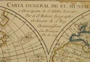
Condition: ACEPTABLE. De Juan Manuel Girón, A costa de Pedro Gendron Año 1756 Los mapas firmados en plancha por el sr. Roberto, geógrafo ordinario de el Rey con privilegio. Año 1754 Muy curioso pequeño Atlas, (28 x 22 cms.) con los famosos mapas de Vaugondy en español. Editados por Pedro Gendron. Pedro Gendron cártografo y editor de los primeros mapas de España antes que Tomás López. 14 mapas acuarelados cada uno con una o dos hojas de explicación o índice. La portada y frontispicio son ejemplares facsímiles copiados del ejemplar de la Biblioteca Nacional de España. La encuadernación es reciente en media piel y papel de aguas. Títulos : - Introducción para el conocimiento de los mapas (mapa inventado) - Carta General del Mundo - La Europa - El Africa - El Asia - La America Meridional -La America Septentrional - Reynos de España y Portugal - Parte meridional del Reyno de Portugal - Parte septentrional del Reyno de Portugal - El Reyno de Francia - El Imperio de Alemania - La Italia - El Reyno de Inglaterra Formato (cm): 22x28.
-

Los Reynos de Espana y Portugal.
Published by Londres (Madrid?) 1760 ca., 1760
Seller: Libreria Ex Libris ALAI-ILAB/LILA member, Roma, RM, Italy
Seller rating 5 out of 5 stars
Map
Incisione originale su rame (cm. 65x48 più ampi margini bianchi). Coloritura coeva all'acquerello. Ottimo esemplare. Rara.
-

El Africa dividida en todos sus principales Reynos.
Published by Londres (Madrid?) 1760 ca., 1760
Seller: Libreria Ex Libris ALAI-ILAB/LILA member, Roma, RM, Italy
Seller rating 5 out of 5 stars
Map
Incisione originale su rame (cm. 60,5x48 più ampi margini). Coloritura coeva all'acquarello. Ottimo esemplare. Rara.
-
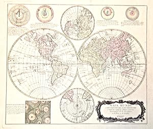
Mapa Mundi o descripcion del globo terrestre compuesta seg?n las ultimas y nuevas observationes de las academias y de Paris y de Londres.
Published by Londra (ma Madrid), 1770
Seller: libreria antiquaria perini Sas di Perini, Verona, VR, Italy
Seller rating 5 out of 5 stars
Art / Print / Poster
Copper engraving, original colour, mm 480x555. Rare spanish map showing four different systems of the universe and Descartes' vortex theory at bottom. Full margins, very good condition, traces of glue on verso.Incisione in rame, colorata d'epoca, mm 480x555. Rara carta spagnola con doppi emisferi e emisferi polari, in alto quattro diversi sistemi dell'universo, da Tolomeo a Brahe, mentre in basso Ë illustrata la teoria dei vortici di Cartesio. Pieni margini, ottime condizioni, traccia di colla al verso. Nr.cat: P8190014.
-
![Seller image for EL 'SENOR DEL ZOCO' EN ESPANA: EDADES MEDIA Y MODERNA, CONTRIBUCION AL ESTUDIO DE LA HISTORIA DEL MERCADO. Préface de Maxime Rodinson [en français]. for sale by Librairie Le Trait d'Union sarl.](https://pictures.abebooks.com/inventory/md/md30520157871.jpg)
EL 'SENOR DEL ZOCO' EN ESPANA: EDADES MEDIA Y MODERNA, CONTRIBUCION AL ESTUDIO DE LA HISTORIA DEL MERCADO. Préface de Maxime Rodinson [en français].
Language: French
Seller: Librairie Le Trait d'Union sarl., TROYES, France
Association Member: ILAB
Seller rating 5 out of 5 stars
Madrid, Instituto Hispano-arabe de Cultura, 1973. Très fort vol. in-8, cartonnage d'édition rouge, dos lisse titré, gardes marbrées, lxix pp, 761pp, bibliografia, indice general, indice de matérias. PART. I. Un mondo economico: et islam. Caracteriscas musulmanas; al Andalus - Teoria del mercato: modalidades y evolución general - Los aswaq al- Arab; el zoco del Projeta - Los zocos munsulmanes (rurales, urbanos y ferias) - Los súbditos de la actuación del zabazoque - La formación d los precios y su control - Esquema de estudio del mercado - Part II. EL "SENOR DEL ZOCO"Antecedentes pre-islamicos - Fuentes - a wilaya al-suq desde et nacimiento del Islam hasta la caída de los Omeyas orientales - El"gobierno del zoco" en al-Andalus (92-898/711-1492) - El "gobierno del zoco" e los reinos cristianos - La atribuciones teóricas del muhtasib - Evolucion general de la hisba en el mundo musulman. /21B Qqs. griffures sur les plats, par ailleurs en bonne condition. Envoi autographe de l'auteur.
-

La America Dispuesta segun las ultimas y nuevas observationes de las Accademias, y de Paris, y de Londres.
Publication Date: 1756
Seller: Geographicus Rare Antique Maps, Brooklyn, NY, U.S.A.
Association Member: ABAA ESA ILAB
Seller rating 4 out of 5 stars

Map
Very good. Small marginal mend not impacting printed image. Original wash color. Size 18 x 20.5 Inches. This is a scarce c. 1756 Spanish-language map of the Americas attributed to Pedro Gendron. This map is significant for its novel illustration of de L'Isle's Sea of the West. An Unusual Imprint The Spanish mapmaker first produced, in 1754, a virtually unacquirable map La America: dispuesta segun el Sistema de Mr. Hasius Profesor de Mathematicas en la Vniversidad de Witembergo, añadidos los ultimos descubrimientos por M. de Lisle . That map - probably printed in Madrid - was a translation of the authoritative mapping of Johann Matthias Hase, updated to include J.-N. De l'Isle's newly-theorized Sea of the West. The present work, printed in London, reproduced that work, without cartographic changes, on a new plate with a different cartouche and title. A Closer Look The map's style and coloration are strongly reminiscent of German maps of the period which provided Gendron's source material. Hase's map, published by Homann Heirs in Nuremberg, was itself informed by French geographer Guillaume De l'Isle. This is most evident in North America in the reasonably accurate Mississippi and the depiction of the Great Lakes (devoid of the phantom islands introduced by Charlevoix). As with the maps of Hase and De l'Isle, this map covers the Western Hemisphere from Pole to Pole and from the Marquesas to include the Guinea coast of Africa, the Atlantic coast of Europe, and the Western Mediterranean Sea. The map's treatment of South American geography was mostly restricted to the coastline, with a broad-brush treatment for the Amazon and the Rio de la Plata. The South Pacific showed islands associated with the explorations of Magellan (1520), Mendana (1595), Quiros (1605). Identifiable islands include 'Terre decouverte par Davis,' the Marquesas, and the Galapagos Islands. Easter Island ( Isla de Pascua ) appears as well. The Sea of the West In the Pacific Northwest, Gendron has included a feature not found on Hase's map: a tremendous bay penetrating almost twenty degrees of latitude into the continent called the Sea of the West. This bay is drawn from the Joseph-Nicolas de l'Isle's 1753 pamphlet Nouvelles cartes des decouvertes de l'Amiral de Fonte, et autres navigateurs espagnols, portugais, anglois, hollandois, françois et russes, dans les mers septentrionales . The text was the most thorough argument for the existence of this body of water, a concoction derived from the account of the fictional Admiral De Fonte and suspect interpretations of the actual discoveries of Juan de Fuca and Martin Aguilar. De l'Isle's illustrious elder brother Guillaume had speculated about the possible existence of the Sea of the West. However, he was unwilling to stake his reputation on it, going so far as to sue to prevent the mapmaker Nolin from plagiarizing De l'Isle's unpublished sketches of the notional sea. The younger Hoseph-Nicolas De l'Isle, eager to make boldly sensational claims before the French Academie des Sciences, had no such scruples: he produced several maps displaying the imaginary bay and its surrounding geography in his 1753 pamphlet. The delineation used here was unique to the map Carte Generale des Découvertes De l'Amiral de Fonte , which depicted the Sea of the West in conjunction with a tantalizing northwest passage attributed to de Fonte. While Gendron's map only shows the western extreme of the de Fonte geography along the top edge of the map, the selection of this source over the others presented by De l'Isle suggests the broad impact of the source map. Publication History and Census This plate was engraved by an anonymous engraver (ostensibly in London) and closely copied from Pedro Gendron's 1754 map. McGuirk dates this London version of the map c. 1756 and notes that it was accompanied by a group of maps, likewise with this work's London imprint. These maps, all in Spanish, were produced uniformly based on Gendron's 1754 works.


