Handkerchief Map (4 results)
 More images
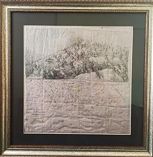
Published by no publisher, c. 1850. 1850
- Map
Seller: Michael S. Kemp, Bookseller, Sheerness, KENT, United KingdomMichael S. Kemp, Bookseller
Contact seller5-star sellerCondition: Used
US$ 537.00
US$ 53.20 shippingShips from United Kingdom to U.S.A.Quantity: 1 available
Handkerchief map printed in black and red, 575 x 575 mm. Some light staining and a small hole on the lower margin. A rare survival.

McIntire's Pocket Handkerchief and Guide of New York City.
1869 Bridgman Cloth Handkerchief Guide and Map of New York City
- Hardcover
- Map
Seller: Geographicus Rare Antique Maps, Brooklyn, NY, U.S.A.Geographicus Rare Antique Maps
Contact seller4-star sellerHardcover. Good. Printed on cloth. Some soiling. Size 17.5 x 17.5 Inches. This is a rare c. 1869 Bridgman and McIntire pocket guide map of New York City. It follows shortly after the development of New York's Elevated Train System - the city's first viable public transportation and the precursor of the modern system. Straphanger…s need a practical guide, and what could be better than the 'weatherproof,' 'tearproof,' and utilitarian handkerchief map - wipe the sweat from your brow and find your way! Published as 'McIntire's Pocket Handkerchief Guide of New York City,' the map depicts Manhattan from the Battery north to West 155th Street and the southern Bronx. Railroads in New York Elevated train lines along Second, Third, Sixth, Ninth, and Tenth Avenues are illustrated and generally labeled 'Manhattan Elevated Rail Road.' Railroads played an important role in New York City in the mid-19th century, but only the New York Central and Hudson Railroad and the New York and New Haven Railroad operated rail lines in Manhattan. All other rail lines ended on the banks of the Hudson River in New Jersey, and passengers were transported across the river by ferry. Even the Long Island Railroad did not operate in Manhattan at the time, with passengers directed to a ferry. Also, there were not yet bridges across the East River, thus necessitating ferry lines between Williamsburg and Manhattan. A Closer Look Streets and avenues throughout Manhattan are identified. New York served as a major commercial center, with most imports arriving by sea. Piers line the Hudson River and the East River in Lower Manhattan, many of which are identified by the operating shipping or railroad line. A handful of landmarks are identified, such as the American Museum of Natural History (which opened in 1869), Grand Central Station, and an insane asylum in the Upper West Side. Central Park appears in some detail, with Croton Reservoir, two receiving reservoirs, and The Ramble noted. Indexes of points of interest and ferries across the East and North rivers occupy the upper left, while indexes of railroads, hotels, and amusements appear in the lower right. Dating This Piece Although undated, we used the American Museum of Natural History (which opened in 1869) and the absence of the Metropolitan Museum of Art (which opened in 1870) to arrive at the c. 1869 date. Publication History and Census This map was created and printed by Bridgman Maps and published by McIntire c. 1869. This is the only known cataloged example.

It's a Long, Long, Way to Tipperary, My Heart's Right There.
1914 World War I Pictorial Cloth Handkerchief Map of the British Isles
- Hardcover
- Map
Seller: Geographicus Rare Antique Maps, Brooklyn, NY, U.S.A.Geographicus Rare Antique Maps
Contact seller4-star sellerHardcover. Very good. Cloth handkerchief. Slightly faded color. Size 12.75 x 14 Inches. This is a c. 1914 pictorial handkerchief of the British Isles illustrating the connection between British soldiers deployed on the Western Front in World War I (1914 - 1918) and their wives/sweethearts back home in Britain. A Closer Look A Br…itish soldier is illustrated in France carrying a rifle and waving his hat at the British Isles, which are personified by three women and a young girl. The women are impeccably dressed and are waving handkerchiefs in response. The last two lines of the chorus of the popular song 'It's a Long, Long Way to Tipperary' are included along the top. 'It's a Long, Long Way to Tipperary' 'It's a Long, Long Way to Tipperary' was a British music hall song written by Henry James 'Harry' Williams and Jack Judge. The song is about an Irishman in London missing his 'sweetest girl' in Tipperary, a county in rural Ireland. The song was immensely popular among British soldiers during World War I, probably since it was a lament for a love left behind. Thus, it is included on this handkerchief, which was designed as a memento for soldiers. Capturing the Historical Moment As this handkerchief is untitled except for lyrics to a popular song, tracing its origins and rarity are difficult. Nonetheless, this piece captures a moment in history and represents the deep connections between a soldier and the homefront.
[THE GRECO-TURKISH WAR MAP ON A SILK HANDKERCHIEF MADE IN YILDIZ PALACE] Devlet-i Aliyye ve Yunan Muhaberebesi. Engraved map of the Greco-Turkish War in 1897 on a silk handkerchief made in Yildiz Palace in the period of Sultan Abdulhamid II.
[YILDIZ PALACE MAP ON SILK HANDKERCHIEF FOR THE SOCIAL AIDS IN THE PERIOD OF SULTAN ABDULHAMID 2].
Language: Turkish, Ottoman (1500-1928)
Published by [Yildiz Palace]., [Dated fî 19 Agustos 1313], Istanbul 1897
- Map
Seller: Khalkedon Rare Books ABA, ILAB, IOBA, ESA, Istanbul, TurkeyKhalkedon Rare Books ABA, ILAB, IOBA, ESA
Contact seller5-star sellerCondition: Used - Very good
US$ 800.00
US$ 20.71 shippingShips from Turkey to U.S.A.Quantity: 1 available
No Binding. Condition: Very Good. Original engraved map on the silk handkerchief made in Yildiz Palace for the 'Iane Sergisi' [i.e. Exhibition of the Social Assistance] in the period of Sultan Abdülhamid II. In its decorative frame. Frame size: 53,5x53,5 cm; map size: 38x38 cm. In Ottoman script. Scale: 1/600.000. Several minima…l splits, minor foxing, and slight stains on cloth. Otherwise in good condition. A rare and decorative 1897 silk handkerchief map of the Greco-Turkish War in 1897, which was the only war in which the Ottoman army was victorious during the reign of Abdulhamid 2, is a fine example of Ottoman / Turkish cartographic textiles made in Ottoman court (Yildiz Palace textile workshops). This beautiful map depicts an attractive war scene from the 1313 Greek War on the upper half, and it's engraved a map of Balkan & Greek lands on its lower half. War painting has 'Melona' signature in Ottoman script. The map shows Thessaloniki [i.e. Salonica] Bay on the west; Yanya [i.e. Ioanna] Vilayat on the east; lands of Greece, Galos Bay, Uzi Strait on the south and Dimetoka and Avalonia areas in the Serefiye, Ergiri sanjaks on the north in its period. Written on the map, "Baht-i himâye-yi feyzvâne-i cenâb-i hilâfetpenâhide evlad-i süheda ve mecrûhin-i asakir-i sâhâne", [i.e. It was printed for the "Iane Sergisi" (i.e. The Social Help Exhibition) in the high memory of our soldiers who were martyred and veterans in the Greek War under the patronage of the Sultan.]. The Greco-Turkish War of 1897, also called the Thirty Days' War and known in Greece as the Black '97 (Mauro '97), or the Unfortunate War (Atychis polemos), was a war fought between the Kingdom of Greece and the Ottoman Empire. Its immediate cause was the question over the status of the Ottoman province of Crete, whose Greek majority long-desired union with Greece. Despite the Ottoman victory on the field, an autonomous Cretan State under Ottoman suzerainty was established the following year (as a result of the intervention of the Great Powers after the war), with Prince George of Greece and Denmark as its first High Commissioner. This was the first war effort in which the military and political personnel of Greece were put to test since the Greek War of Independence in 1821. For the Ottoman Empire, this was also the first war effort in which the reorganized military personnel were put to test. The Ottoman army was under the guidance of a German military mission led by Colmar Freiherr von der Goltz, who had reorganized it after the defeat in the Russo-Turkish War (1877-1878). The conflict proved Greece was wholly unprepared for war. Plans, fortifications and weapons were non-existent, the mass of the officer corps was unsuited to its tasks, and training was inadequate. As a result, the numerically superior, better organized, equipped and led Ottoman forces pushed the Greek forces south out of Thessaly. Almost all of the aids made to the families or disabled people of those who were martyred in the 1897 Ottoman-Greek War (such as printing this map) were made within the framework of the donations of "Evlâd-i Süheda and Malûlîn-i Guzât-i Asâkir-i Sahane". People and citizens of all classes and beliefs, including members of the Ottoman court, ministers, bureaucrats, civil servants, merchants and tradesmen, participated in this aid campaign at the end of the 19th, beginning of the 20th century. Not in OCLC.


