Order Total (1 Item Items):
Shipping Destination:

Hetreau (33 results)
Author:
hetreau
Refine with Advanced Search
Skip to main search results
Search filters
Product Type
- All Product Types
- Books (20)
- Magazines & Periodicals (No further results match this refinement)
- Comics (No further results match this refinement)
- Sheet Music (No further results match this refinement)
- Art, Prints & Posters (5)
- Photographs (No further results match this refinement)
- Maps (8)
- Manuscripts & Paper Collectibles (No further results match this refinement)
Condition Learn more
- New (No further results match this refinement)
- As New, Fine or Near Fine (13)
- Very Good or Good (1)
- Fair or Poor (No further results match this refinement)
- As Described (19)
Binding
Collectible Attributes
- First Edition (3)
- Signed (No further results match this refinement)
- Dust Jacket (No further results match this refinement)
- Seller-Supplied Images (29)
- Not Print on Demand (33)
Language (2)
Free Shipping
- Free Shipping to U.S.A. (No further results match this refinement)
Seller Location
Seller Rating
-

Hardcover. Condition: Bon. Halfbob (illustrator). Ancien livre de biblioth�que avec �quipements. Edition 2019. Livre reconditionn� de biblioth�que. Ammareal reverse jusqu'� 15% du prix net de cet article � des organisations caritatives. ENGLISH DESCRIPTION Book Condition: Used, Good. Former library book. Edition 2019. Refurbished library book. Ammareal gives back up to 15% of this item's net price to charity organizations.
-
Hardcover. Condition: Tr�s bon. Halfbob (illustrator). Ancien livre de biblioth�que avec �quipements. Ammareal reverse jusqu'� 15% du prix net de cet article � des organisations caritatives. ENGLISH DESCRIPTION Book Condition: Used, Very good. Former library book. Ammareal gives back up to 15% of this item's net price to charity organizations.
-

Le mouchoir rouge Suivi de La chasse au Caribou Lithographies de R�my H�treau Les Editions de la Tour 1945
Published by Les �ditions de la Tour 1945, 1945
Seller: JLG_livres anciens et modernes, Saint Maur des Foss�s, France
Seller rating 5 out of 5 stars

Condition: Tr�s bon. Nos envois se font avec suivi, pour tout probl�me n'h�sitez pas � nous contacter pour trouver une solution.
-
Le Mouchoir Rouge suivi de La Chasse au caribou
Language: French
Published by Les Editions de la Tour, Paris, 1945
Couverture rigide. Condition: Bon. HETREAU R�mi (illustrator). Cartonnage d'�diteur, trois tranches dor�es. 1945. 15,5 x 9,5 cm. 137 [9] pages. Lithographies de R�mi H�treaul. 3i�me vol. de la collection "Le Rouge et le Noir". Edition num�rot�e, un des 967 ex. sur v�lin pur chiffon (n� 405). BON ETAT. Coiffes un peu us�es, coins frott�s. Empreintes en relief sur pages liminaires.
-

Le grand Will. Drame historique en 3 actes.
Language: French
Published by Editions de la nouvelle France, Paris, 1945
Seller: L'ivre d'Histoires, Merbes Sainte Marie, Belgium
Seller rating 5 out of 5 stars
Couverture souple. Condition: Bon. H�treau R�my (illustrator). Collection "Pr�f�rences", n�2, quelques rousseures en premi�re de couverture.
-

Un Don Juan
Language: French
Published by Les �ditions de la Nouvelle France, Paris, 1946
Seller: L'ivre d'Histoires, Merbes Sainte Marie, Belgium
Seller rating 5 out of 5 stars
Couverture souple. Condition: Bon. H�treau R�my (illustrator). Collection "Pr�f�rences".
-

Couverture souple. Condition: Comme neuf. 60p, illustr� coul. tr�s nombreuses reproductions, (+1-927-08).
-
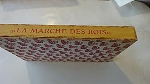
La Marche des Rois. Illustrations de R�my H�treau.
Language: French
Published by Laffont, Paris, 1944
Seller: BALAGU� LLIBRERIA ANTIQUARIA, Santa Coloma de Farners, GI, Spain
Seller rating 5 out of 5 stars
Caja Editorial. Condition: Muy bueno. R�my H�treau (illustrator). Primera edici�n. 99 pp. en buen papel de hilo. Sumamente y bellamente ilustrado con grabados a color. Muy cuidada edici�n limitada y numerada de mil ejemplares. Size: 27 x 18 Cm.
-
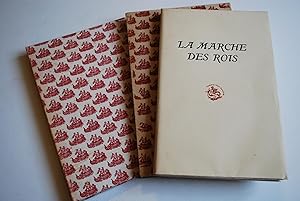
La Marche des Rois [ Edition originale ]
Language: French
Published by Robert Laffont, 1944
First Edition
rigide. Condition: Bon. Illustrations de R�my H�treau, exemplaire sur v�lin blanc de Rives num�rot�, 1 vol. grand in-8 reliure plein chagrin lie-de-vin, couvertures conserv�es, Robert Laffont, Paris, 1944, 96 pp. Bon �tat (reliure partiellement pass�e, des rouss.) Langue: Fran�ais.
-

LES ORAISONS FUNEBRES DE BOSSUET - EVEQUE DE MEAUX. COLLECTION PREFERENCES.
Published by NOUVELLE FRANCE, 1947
Couverture souple. Condition: bon. ROD0102367: 1947. In-8. Broch�. Bon �tat, Couv. convenable, Dos satisfaisant, Int�rieur frais. 267 pages. Quelques illustration en noir et rouge dans et hors texte. Fronctispice en noir et rouge. . . . Classification Dewey : 200-RELIGION.
-
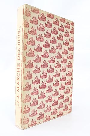
LA MARCHE DES ROIS
Language: French
Published by ROBERT LAFFONT, PARIS, 1944
Seller: LIBRAIRIE PHILIPPE BERTRANDY, LE PUY EN VELAY, France
Seller rating 5 out of 5 stars
Couverture rigide. Condition: Tr�s bon. Un volume grand in-8 broch� de 97 pages , couverture rempli�e et bien complet de l'embo�tage �diteur , illustrations en couleurs de R�my HETREAU , tirage � 1000 ex. num�rot�s , un des 900 sur velin de Rives ( N� 51 ) , l�gers d�fauts � l'embo�tage , l' ouvrage est en tr�s bon �tat .
-
L'Hotel du nord.
Language: French
Published by Deno�l, Paris, 1944
Seller: Librairie les mains dans les poches, Tourbes, France
Seller rating 5 out of 5 stars
Couverture souple. Condition: Tr�s bon. R�my H�treau (illustrator). Petit in-4 de 210-(1) pp.; en feuilles, sous couverture rempli�e, chemise et �tui cartonn�s de l'�diteur. Illustr� de cinquante-six eaux-fortes par R�my H�treau. Tir� � 301 exemplaires, un des 270 sur v�lin de Rives, num�ro 113. Bel exemplaire.
-
Genevi�ve. Avec dix-neuf eaux-fortes de Remy H�treau
Published by Librairie Gallimard, nrf, Paris, 1947
Couverture souple. Condition: Tr�s bon. Remy H�treau (illustrator). 167 pages. Roman de l'�crivain et critique dramatique fran�ais, Jacques Lemarchand (1908-1974), qui fut par ailleurs �galement directeur de collection chez Gallimard (Source : Wikip�dia). Il a �t� tir� de cette �dition 274 exemplaires sur v�lin de Rives B.F.K. , num�rot�s de 27 � 286 (apr�s 32 exemplaires sur un autre papier) et VII � XX pour les 14 hors commerce. Notre exemplaire est marqu� 251. Les eaux-fortes de Remy H�treau (1913-2001), furent imprim�es par Roger Lacouri�re, � Paris. Couverture souple, rempli�e, fond couleur saumon, papier pergamine de protection. Embo�tement rigide de l'�diteur. Etat : tr�s bon. Embo�tement : assez bon, quelques frottements et in�vitables ombres de salissures, mais encore bien solide. 25.3 x 16.5 x 2.5 cm 800g.
-
La marche des rois
Published by Robert Laffont, 1944
Seller: Librairie Le Feu Follet, Paris, France
Association Member: ILAB
Seller rating 5 out of 5 stars
Art / Print / Poster First Edition
couverture souple. Robert Laffont | Marseille 1944 | 17 x 26 cm | en feuilles sous chemise et �tui | Edition originale, un des 950 exemplaires num�rot�s sur v�lin blanc de Rives, seuls grands papiers apr�s 50 verg� teint� de Vidalon. Ouvrage illustr� de18 compositions originales de R�my H�treau grav�es sur bois et aquarell�es au pochoir. Agr�able exemplaire. | [ENGLISH DESCRIPTION FOLLOWS] First edition, one of 950 numbered copies on white Rives laid paper, the only deluxe copies after 50 on tinted Vidalon laid paper. Work illustrated with 18 original compositions by R�my H�treau engraved on wood and hand-colored with pochoir. Handsome copy. *.
-
Le mouchoir rouge Suivi de La chasse au Caribou Lithographies de R�my H�treau Les Editions de la Tour 1945
Published by Les �ditions de la Tour 1945
in-12, cartonnage illustr� �diteur, jaquette, 138p, tranche dor�e, ex sur v�lin du Marais n� 645/ 975, bel �tat.
-
En Arri�re. Nouvelles. Pointes s�ches de R�my H�treau. �dition originale
Published by La Parade,, s. l.,, 1949
Seller: Librairie Ancienne Richard (SLAM-ILAB), NANTES, France
Association Member: ILAB
Seller rating 4 out of 5 stars

First Edition
330 x 255 mm, 67-(5) pp., pointes s�ches de R�my H�reau en pleine page dont 1 en double-page. En feuilles, sous chemise cartonn�e rempli�es, �tui, �tui choqu� et sali aux bords, dos et bordure int�rieure des couvertures insol�s, minime d�chirure entre dos et premi�re de couverture, claires d�charges de la couvertures rempli�es sur premier et dernier feuillet blanc, les pointes s�ches sont prot�g�es par serpentes, tr�s bel �tat int�rieur. Tirage � 150 exemplaires num�rot�s. Bel exemplaire. "Ce livre a �t� achev� d'imprimer � Massy le 20 janvier 1949, sur la presse � bras de Michel Brient. Il en a �t� tir� cent cinquante exemplaires, � savoir vingt-cinq exemplaires avec suite num�rot�s de 1 � 25 ; cent vingt-cinq ex. num�rot�s de 26 � 150, & quelques hors commerce, le tout constituant l'�dition originale.".
-

French Vineyards Burgundy Wine
Published by France, 1950
Seller: AntikBar Original Vintage Posters, London, UK, United Kingdom
Seller rating 4 out of 5 stars
Art / Print / Poster
US$ 619.32
US$ 40.09 shipping
Ships from United Kingdom to U.S.A.Quantity: 1 available
Add to basketRemy Hetreau (illustrator). Original vintage drink advertising poster promoting French wines (one of a series issued by the Comite National de Propagande en Faveur du Vin national committee for the promotion of wine): Les Vignobles de France Vins de Bourgogne / The French Vineyards Wines of Burgundy featuring a colourful decorative map of the Bourgogne region marking the river Rhine and the vineyards with bunches of grapes and images of vineyards, a chateau, jug of wine, basket of grapes, coats of arms, a glass and bottle of wine on a picnic cloth and a lady wearing a traditional style dress and white bonnet hat on the side, surrounded with vine leaves on a background of wood with a smaller map of Chablis nailed on the left and a lantern hanging on the right, set against a blue background. Horizontal. Fair condition, foxing, staining, browning on edges, creasing, restored tears, tears. Size: 68x84.5cm.
-
ORIGINAL "EXPOSITION ARTISANS CREATEURS" FRENCH GALLERY POSTER
Published by Imp. S.A. Courbet, Paris, 1964
Seller: Second Story Books, ABAA, Rockville, MD, U.S.A.
Seller rating 4 out of 5 stars
Art / Print / Poster
Original poster in metallic frame measuring 15.25 in. x 25.25 in. Poster not examined out of frame. Condition of is Very Good with light age toning, light wrinkling/creasing. and remnants of adhesive along the top margin. AP Consignment. Shelved in Rockville Room B. [This is an oversized item. Additional postage necessary for expedited and international orders. Economy International shipping unavailable due to size/weight restrictions. For international/expedited customers, please inquire for rates]. 1381020. Special Collections - Upstairs.
-
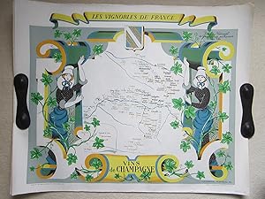
Vins de Champagne.
Published by Publi-Mab, Paris, 1950
Seller: Angelika C. J. Friebe Ltd. - MapWoman, Dorking, United Kingdom
Seller rating 5 out of 5 stars
Map
US$ 447.28
US$ 26.72 shipping
Ships from United Kingdom to U.S.A.Quantity: 1 available
Add to basketNo Binding. Condition: Near Fine. colour printed map. overall 68 x 84 cm. edges slightly frayed; some smaller marginal tears; some repaired;corners slightly bent; o/w exc. cond.- A beautifully decorated map of the French vine region of Bordeaux from Hetreau's Les Vignobles de France', showcasing the French wine regions with detailed and decorative borders.
-

French Vineyards Loire Valley Wine
Published by France, 1950
Seller: AntikBar Original Vintage Posters, London, UK, United Kingdom
Seller rating 4 out of 5 stars
Art / Print / Poster
US$ 550.50
US$ 40.09 shipping
Ships from United Kingdom to U.S.A.Quantity: 1 available
Add to basketRemy Hetreau (illustrator). Original vintage drink advertising poster promoting French wines (one of a series issued by the Comite National de Propagande en Faveur du Vin national committee for the promotion of wine): Les Vignobles de France Vins du Val de Loire / The French Vineyards Wines of the Loire Valley featuring a colourful decorative map of the Val de Loire region marking the river and the vineyards with bunches of grapes in red and white, a sailing boat at sea and a chateau and lighthouse behind an image of wine barrels loaded on a wooden boat below, a man smoking a pipe and a lady in a dress holding up the map as a scroll with a white dove carrying a vine leaf in its beak and a sun in the centre of the compass above, three coats of arms and trailing vines adorn the design on the pink and blue background. Horizontal. Fair condition, creasing, restored tears, tears, browning on edges, paper loss. Size: 68x84.5cm.
-
L'H�tel du Nord.
Paris, Les Editions Deno�l, 1944. Un fort vol. au format pt in-4 (253 x 193 mm) de 210 pp., sous couverture � rabats rempli�s. Tirage unique � 301 exemplaires. Celui-ci comptant parmi les 270 num�rot�s du tirage sur v�lin de Rives. Il s'agr�mente de 56 eaux-fortes in et hors-texte de R�my H�treau. ''El�ve de l'Ecole Boulle, R�my H�treau tint une place pr�pond�rante dans la d�coration et l'imagerie. D�corateur, il n'en est pas moins appr�ci� comme illustrateur. Il a ainsi orn� de figures gracieuses et solides L'H�tel du Nord, ou encore des ouvrages de del Vasto, Gobineau, Lemarchand, Aym� ou Nerval.'' (in B�n�zit). ''Eug�ne Dabit conte ici la vie et la mort du petit h�tel du quai de Jemmapes, encore debout aujourd'hui, et qui a inspir� � Marcel Carn� l'inoubliable H�tel du Nord, avec Arletty, Louis Jouvet, Bernard Blier.'' B�n�zit V, Dictionnaire des peintres, p. 525 - Monod I, 477. Coiffes l�g�rement �lim�es. Petite coupe en t�te du dos. Quelques rousseurs dans le texte ; davantage marqu�es aux trois premiers feuillets. Du reste, bonne condition.
-

1954 A fine original vintage FRENCH WINE VINEYARD Advertising Poster Remy Hetreau
Seller: Antique Paper Company, ASHFORD, KENT, United Kingdom
Seller rating 2 out of 5 stars

US$ 412.88
US$ 8.02 shipping
Ships from United Kingdom to U.S.A.Quantity: 1 available
Add to basket1954.Original vintage drink advertising poster promoting French wines (one of a series issued by the Comite National de Propagande en Faveur du Vin national committee for the promotion of wine): Les Vignobles de France Vins des Cotes du Rhone / The French Vineyards Cote du Rhone Wines featuring a colourful decorative map of the Rhone region in southern France marking the rivers and the vineyards with bunches of grapes held by a lady in a traditional white bonnet and dress standing in front of an archway with a chateau, bridge over the flowing river and chapel in the background, bottles with glasses of wine on wooden barrels and a table surrounded by trailing vine leaves and three coats of arms above and on the sides below. Horizontal.Overall size approx 82cm x 66cm. Condition generally good with some professionally restored teams in the margins.
-

1954 Les Vignobles de France | Vins de Roussillion Midi Provence
Seller: New World Cartographic, Chicago, IL, U.S.A.
Seller rating 4 out of 5 stars
Map
By: Remy HetreauDate: 1954 (published) FranceDimensions: 23.5 x 31 inches (59.7 cm x 78.75 cm)A splendid original, vintage travel poster promoting the wine regions in the south of France.The map was made aspart of a series commissioned by the Comite National de Propagande en Faveur du Vin to celebrate and promote the legendary wine regions of France. French artist, illustrator and print maker, Remy Hetreau took on this task, creating some magnificent posters highlighting local wineries of eight different regions.The title is contained in a ribbon cartouche at the top of the map. Here Hetreau presents a scroll background on which are positioned a young man and woman holding a map of the Languedoc-Roussillion province in southern France that is bordered by the Mediterranean Sea. Grape vines nearly surround the entire map, of which barrels from the towns of Montpellier, Nimes, and Beziers are suspended. At the bottom, an anchor is wrapped in a long ribbon featuring the port towns of Sete, Narbonne, and Perpignan.Languedoc-Roussillon wine comes from the region of France that spans the Mediterranean coastline from border with Spain to the region of Provence. With over 700,000 acres devoted to vineyards, it is the single biggest wine-producing region in the world, being responsible for more than a third of Frances total wine production.Condition: This map is in A condition, with some paper crinkling and smalltears confined to the left and right margins. The map boasts rich color over clean paper with full margins on all sides.Inventory #120981200 W. 35th Street #425 Chicago, IL 60609 | P: (312) 496 - 3622.
-

1954 Les Vignobles de France | Vins de Champagne
Seller: New World Cartographic, Chicago, IL, U.S.A.
Seller rating 4 out of 5 stars
Map
By: Remy HetreauDate: 1954 (published) FranceDimensions:25.5 x 31 inches (64.75 x 78.75 cm)A marvelousmid-century travel poster from 1954 made to promote tourism to the Champagne Region of France. It was part of a series of maps commissioned by theComite National de Propagande en Faveur du Vinto celebrate and promote the legendary wine regions of France. Remy Hetreau, Frenchillustrator and print maker took on this task, creatinga set of magnificent posters highlighting local wineries of eight different regions.The title is contained in a ribbon cartouche at the top of the map.Two maidens hold open a rolled map of the Champagne province of France, located in the northeast section of the country some 150 kilometers due east of Paris. Grape vines intertwine with baroque style scrollwork that surrounds the map on all sides. The mapidentifies nearly one hundred vineyards located between and around the towns ofTroyes, Epernay, Chalons Sur Marne, andReims, all of which are marked with white grapes.Champagneis the region where the sparkling white wine first originated and today,EU law and the laws of most countries reserve the term "Champagne" exclusively for wines that come from this region. The first recorded export of wine from the region wasreceived in 1518 by Henry VIIIs chancellor located in England. Production would increase dramatically during the 19th century from 300,000 bottles a year in 1800 to 20 million bottles in 1850. Over time, the wine increasingly became a symbol of celebration and in 1999 a record327 million bottles was set inpreparation for thecelebrations of the new millennium.Condition: This map is in A condition, boasting rich color over clean paper with full margins on all sides. This piece has been linen-backed for preservation and presentation purposes, a reversible process.Inventory #120961200 W. 35th Street #425 Chicago, IL 60609 | P: (312) 496 - 3622.
-

Les Vignobles de France. Vins de Roussillon Midi Provence.
Publication Date: 1954
Seller: Geographicus Rare Antique Maps, Brooklyn, NY, U.S.A.
Association Member: ABAA ESA ILAB
Seller rating 4 out of 5 stars
Map
Excellent. Light creasing. Size 25 x 30.5 Inches. This is a c. 1954 R�my H�treau pictorial wine map of the Languedoc, Roussillon, and Provence wine regions in France. Languedoc-Roussillon is the largest wine region in France. A Closer Look Depicting the French Mediterranean coast from the Spanish border east past Nice, major wine regions are identified with color-coded text. Grape varietals, specific wine regions, and even individual vineyards are referenced. Red and yellow grape bunches dot the map near specific named wineries. Several major cities are labeled, including Carcassonne, Perpignan, Marseille, Nice, Montpelier, Nimes, Arles, Avignon, and Toulon. St. Tropez is also identified. The region's rivers are illustrated since river valleys are important to viticulture. Two vineyard workers appear above and to the left of the map, while grape vines surround the piece. Sete, Narbonne, Perpignan, B�ziers, Nimes, and Montpelier are highlighted in the border, perhaps underscoring their importance to local wine production. Publication History and Census This map was created by R�my H�treau and published by the Comit� National de Propagande en Faveaur du Vin c. 1954. We note a single cataloged example, which is part of the David Rumsey Map Collection. This map appears on the private market occasionally. An earlier edition was published c. 1950. References: Rumsey 12318.000.
-

Les Vignobles de France. Vins d'Alsace.
Publication Date: 1954
Seller: Geographicus Rare Antique Maps, Brooklyn, NY, U.S.A.
Association Member: ABAA ESA ILAB
Seller rating 4 out of 5 stars
Map
Excellent. Size 25 x 30 Inches. This is a 1954 R�my H�treau pictorial wine map of the Alsace wine region, France. The map highlights local wineries and culture. A Closer Look Coverage embraces from Strasbourg to Mulhouse, with bunches of yellow grapes marking vineyards. Colmar, Ribeauvill�, S�lestat, Guebwiller, and Thann are labeled. Grape vines, an Alsatian vinter, and two white storks surround the map. In Alsace, storks symbolize fertility and are associated with luck and wealth. Publication History and Census This map was created by R�my H�treau and published 1954 by the Comit� National de Propagande en Faveur du Vin. This piece does not appear in OCLC, and we have not located any cataloged examples in institutional collections. This piece rarely appears on the private market. An earlier edition drawn by H�treau and published by the Comit� in 1950 differs slightly from the present 1954 edition.
-
"Tendre trio : cerf - biche et faon".
Publication Date: 1950
Seller: Librairie Pierre Chretien - Jean Izarn, PARIS, France
Association Member: ILAB
Seller rating 5 out of 5 stars
. Illustrateur : H�TREAU (R�my). (illustrator). Sculpture originale en pl�tre de fondeur s'assemblant en 2 parties, (1950), 78 x 74 x 27 cm. R�my H�treau (Patay 1913-2001) r�alise des sculptures pour le Salon de l'Imagerie d�s 1944. Un ouvrage lui rend hommage "R�my H�treau un monde enchant�". Avec son �pouse Janine ils firent de nombreuses cr�ations � quatre main comme, peut-�tre, ce trio "Cerf-biche et faon". Restauration au bois. La M�diath�que Marcel Proust organisa une r�trospective "H�treau, l'art en h�ritage". uvre originale.
-
1954 French Wine Map, Val de Loire - R. H�treau
Publication Date: 1954
Seller: L'Affichiste Vintage Posters, Montreal, QC, Canada
Seller rating 4 out of 5 stars
Art / Print / Poster
No Binding. Condition: Good. Date: 1954, Size: 24.5 x 32.75 inches , Artist: R. H�treau, About the poster: The Vall�e de la Loire, often called the "Garden of France," boasts a rich winemaking history that dates back to Roman times. By the early Middle Ages, Loire wines were already prized in royal courts and exported widely. The region's diverse terroirs and temperate climate give rise to an exceptional variety of winesfrom the crisp Sauvignon Blancs of Sancerre and Pouilly-Fum� to the elegant Chenin Blancs of Vouvray and the vibrant reds of Chinon and Saumur. Today, the Loire Valley remains one of France's most dynamic wine regions, celebrated for its authenticity, heritage, and wide-ranging expressions., Top left corner is ruffle. Please see pictures. Ready to frame !
-
Les Vignobles de France. Vins des C�tes du Rh�ne.
Publication Date: 1954
Seller: Geographicus Rare Antique Maps, Brooklyn, NY, U.S.A.
Association Member: ABAA ESA ILAB
Seller rating 4 out of 5 stars
Map
Excellent. Light creasing. Size 25 x 30 Inches. This is a c. 1954 R�my H�treau pictorial wine map of the C�tes du Rh�ne wine region, France. This region produces some of France's finest and most delicious wines. A Closer Look Depicting the Rh�ne Valley from north of Valence south to the Bouches du Rh�ne, red and yellow grape bunches highlight wine-producing areas within the region. Bold block font labels significant wineries, including the famed Ch�teauneuf du Pape. Arles, Aix-en-Provence, Avignon, and Marseille are identified. A French woman dressed in traditional clothing appears to the left, and a gorgeous landscape of vineyards, vines, and ancient buildings surrounds her. Publication History and Census This map was created by R�my H�treau and published by the Comit� National de Propagande en Faveaur du Vin c. 1954. An earlier edition was published c. 1950. Both editions are rare on the private market.
-

Les Vignobles de France. Vins de Bordeaux.
Publication Date: 1954
Seller: Geographicus Rare Antique Maps, Brooklyn, NY, U.S.A.
Association Member: ABAA ESA ILAB
Seller rating 4 out of 5 stars
Map
Very good. Closed margin tears professionally repaired on verso. Size 24.75 x 30 Inches. This is a c. 1954 R�my H�treau pictorial map of the Bordeaux wine region, France - specifically the Gironde Estuary. The map identifies smaller regions as well as specific wineries. A Closer Look Coverage embraces the Gironde Estuary and vicinity. The major wine regions, such as Haut M�doc, Graves, Entre Deux Mers, and Sauternes, are identified, although not explicitly delineated. Yellow squares identify cities, including Bordeaux, Langon, and Libourne. Bunches of red and yellow grapes mark specific wineries. Grape vines surround the map on three sides, with illustrations of a chateau, the sun, and a woman astride a wine cask, creating the rest of the pictorial border. Publication History and Census This map was created by R�my H�treau and published by the Comit� National de Propagande en Faveur du Vin c. 1954. We note a single cataloged example in OCLC, which is part of the collection at Cornell University. Examples appear on the market from time to time. An earlier example, published c. 1950, varies slightly in color and typography. H�treau created a series of 11 maps of wine regions for the Comit� National de Propagande en Faveur du Vin, which include Alsace, Bordeaux, Bourgogne, Champagne, C�te de Provence, C�te du Rh�ne, R�gion Est, R�gion Normandie, Roussillon, and the Val de Loire. The 11th was dedicated to the northern portion of Algeria, which was then considered part of France. References: OCLC 55642959. Rumsey 8476.000 (1950 edition).


![Seller image for La Marche des Rois [ Edition originale ] for sale by Librairie du Cardinal](https://pictures.abebooks.com/inventory/md/md31782054547.jpg)