
Order Total (1 Item Items):
Shipping Destination:

Ingard John (1 results)
Skip to main search results
Search filters
Product Type
- All Product Types
- Books (No further results match this refinement)
- Magazines & Periodicals (No further results match this refinement)
- Comics (No further results match this refinement)
- Sheet Music (No further results match this refinement)
- Art, Prints & Posters (No further results match this refinement)
- Photographs (No further results match this refinement)
- Maps (1)
- Manuscripts & Paper Collectibles (No further results match this refinement)
Condition Learn more
- New (No further results match this refinement)
- As New, Fine or Near Fine (No further results match this refinement)
- Very Good or Good (No further results match this refinement)
- Fair or Poor (No further results match this refinement)
- As Described (1)
Binding
- All Bindings
- Hardcover (No further results match this refinement)
- Softcover (No further results match this refinement)
Collectible Attributes
- First Edition (No further results match this refinement)
- Signed (No further results match this refinement)
- Dust Jacket (No further results match this refinement)
- Seller-Supplied Images (1)
- Not Print on Demand (1)
Language (1)
Price
- Any Price
- Under US$ 25 (No further results match this refinement)
- US$ 25 to US$ 50 (No further results match this refinement)
- Over US$ 50
Free Shipping
- Free Shipping to U.S.A. (No further results match this refinement)
Seller Location
Seller Rating
-
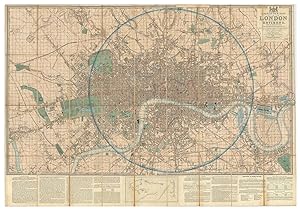
Laurie's New Plan of London and its Environs, with an improved Scale for Ascertaining Distances, the Fares of Hackney Coaches, Porterage of Parcels, &c. By John Lingard.Being an Original Survey by John Outhett with all the Recent Improvements.Dedicated by Permission, to the Right Honourable Lord Viscount Melbourne.
Published by LondonRichard Holmes Laurie. No. 3 Ave Maria Lane ., 1841
Seller: Robert Frew Ltd. ABA ILAB, London, United Kingdom
Association Member: ABA ILAB PBFA
Seller rating 5 out of 5 stars

Map
US$ 1,995.57
US$ 13.36 shipping
Ships from United Kingdom to U.S.A.Quantity: 1 available
Add to basketOriginal hand-coloured engraved plan of London (76 x 110 cm) extending from Hampstead in the north to Camberwell in the south, the East India Docks in the east and Shepherds bush in the west. Dissected into 36 sections and mounted onto linen, with descriptive 'ingenious Scale and Key' beneath 'for ascertaining distances in any direction at one view'. Some slight wear along folds, generally a most attractive example. The key explains that the map was based upon a new survey by John Outhett who, as the note beneath the title explains, based the map upon the trigonometric survey by General William Roy (who inspired the original Ordnance Survey) and extended by a recent survey by Mr. Findlay. Howgego 361 (3).