
Order Total (1 Item Items):
Shipping Destination:

Jode Cornelis (37 results)
Skip to main search results
Search filters
Product Type
- All Product Types
- Books (11)
- Magazines & Periodicals (No further results match this refinement)
- Comics (No further results match this refinement)
- Sheet Music (No further results match this refinement)
- Art, Prints & Posters (12)
- Photographs (No further results match this refinement)
- Maps (14)
- Manuscripts & Paper Collectibles (No further results match this refinement)
Condition Learn more
- New (11)
- As New, Fine or Near Fine (11)
- Very Good or Good (3)
- Fair or Poor (No further results match this refinement)
- As Described (12)
Binding
- All Bindings
- Hardcover (7)
- Softcover (No further results match this refinement)
Collectible Attributes
- First Edition (2)
- Signed (No further results match this refinement)
- Dust Jacket (No further results match this refinement)
- Seller-Supplied Images (33)
- Not Print on Demand (30)
Language (1)
Free Shipping
Seller Location
Seller Rating
-

Plate 8: Ferdinand on horseback crossing the Alps; from Guillielmus Becanus's 'Serenissimi Principis Ferdinandi, Hispaniarum Infantis.', A5
Published by Contentum Ltd., Larnaca, Cyprus
Art / Print / Poster
Loose Leaf. Condition: New. Reproduction. Original title: Plate 8: Ferdinand on horseback crossing the Alps; from Guillielmus Becanus's 'Serenissimi Principis Ferdinandi, Hispaniarum Infantis.' German: Platte 8: Ferdinand zu Pferd durch die Alpen; von Guillielmus Becanus' 'Serenissimi Principis Ferdinandi, Hispaniarum Infantis.' French: Plaque 8: Ferdinand � cheval traversant les Alpes; de Guillielmus Becanus 'Serenissimi Principis Ferdinandi, Hispaniarum Infantis.' Spanish: Placa 8: Fernando a caballo cruzando los Alpes; de Guillielmus Becanus 'Serenissimi Principis Ferdinandi, Hispaniarum Infantis.' High-quality fine-art reproduction based on an original work from the Met. Creation period: 17th century (1636). Professionally printed on premium fine-art paper (Photo Matt Fibre) in size A5. The motif is printed with a white border (museum-style presentation). No.
-

Plate 11: Ferdinand greeted by the Elector of Cologne; from Guillielmus Becanus's 'Serenissimi Principis Ferdinandi, Hispaniarum Infantis.', A5
Published by Contentum Ltd., Larnaca, Cyprus
Art / Print / Poster
Loose Leaf. Condition: New. Reproduction. Original title: Plate 11: Ferdinand greeted by the Elector of Cologne; from Guillielmus Becanus's 'Serenissimi Principis Ferdinandi, Hispaniarum Infantis.' German: Tafel 11: Ferdinand begr��t vom K�lner Kurf�rsten; aus Guillielmus Becanus' 'Serenissimi Principis Ferdinandi, Hispaniarum Infantis.' French: Plaque 11: Ferdinand accueilli par l'�lecteur de Cologne; de Guillielmus Becanus 'Serenissimi Principis Ferdinandi, Hispaniarum Infantis.' Spanish: Placa 11: Fernando saludado por el Elector de Colonia; de Guillielmus Becanus 'Serenissimi Principis Ferdinandi, Hispaniarum Infantis.' High-quality fine-art reproduction based on an original work from the Met. Creation period: 17th century (1636). Professionally printed on premium fine-art paper (Photo Matt Fibre) in size A5. The motif is printed with a white border (museum-style presentation). No.
-

Plate 10: The King of Hungary and Ferdinand on horseback; from Guillielmus Becanus's 'Serenissimi Principis Ferdinandi, Hispaniarum Infantis.', A5
Published by Contentum Ltd., Larnaca, Cyprus
Art / Print / Poster
Loose Leaf. Condition: New. Reproduction. Original title: Plate 10: The King of Hungary and Ferdinand on horseback; from Guillielmus Becanus's 'Serenissimi Principis Ferdinandi, Hispaniarum Infantis.' German: Tafel 10: Der K�nig von Ungarn und Ferdinand zu Pferd; von Guillielmus Becanus' 'Serenissimi Principis Ferdinandi, Hispaniarum Infantis.' French: Plaque 10: Le roi de Hongrie et Ferdinand � cheval; de Guillielmus Becanus 'Serenissimi Principis Ferdinandi, Hispaniarum Infantis.' Spanish: Plato 10: El rey de Hungr�a y Fernando a caballo; de Guillielmus Becanus 'Serenissimi Principis Ferdinandi, Hispaniarum Infantis.' High-quality fine-art reproduction based on an original work from the Met. Creation period: 17th century (1636). Professionally printed on premium fine-art paper (Photo Matt Fibre) in size A5. The motif is printed with a white border (museum-style presentation). No.
-

Plate 1: Ferdinand as Mars, standing on a pedestal; from Guillielmus Becanus's 'Serenissimi Principis Ferdinandi, Hispaniarum Infantis.', A5
Published by Contentum Ltd., Larnaca, Cyprus
Art / Print / Poster
Loose Leaf. Condition: New. Reproduction. Original title: Plate 1: Ferdinand as Mars, standing on a pedestal; from Guillielmus Becanus's 'Serenissimi Principis Ferdinandi, Hispaniarum Infantis.' German: Platte 1: Ferdinand als Mars, auf einem Sockel stehend; aus Guillielmus Becanus' 'Serenissimi Principis Ferdinandi, Hispaniarum Infantis.' French: Assiette 1: Ferdinand comme Mars, debout sur un pi�destal; de Guillielmus Becanus 'Serenissimi Principis Ferdinandi, Hispaniarum Infantis.' Spanish: Placa 1: Ferdinand como Marte, de pie en un pedestal; de Guillielmus Becanus 'Serenissimi Principis Ferdinandi, Hispaniarum Infantis.' High-quality fine-art reproduction based on an original work from the Met. Creation period: 17th century (1636). Professionally printed on premium fine-art paper (Photo Matt Fibre) in size A5. The motif is printed with a white border (museum-style presentation). No.
-

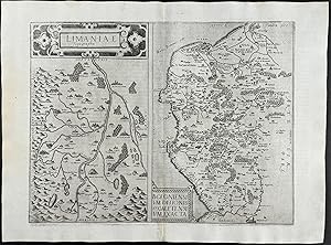
Map of the La Mans Region, France (Nova et Integra Caenomaniae Descriptio Vulg. La Mans)
Published by Antwerp, 1593
Seller: Trillium Antique Prints & Rare Books, Franklin, TN, U.S.A.
Seller rating 3 out of 5 stars

Art / Print / Poster
Condition: Fine. This truly significant map is from one of the rarest atlases ever published, Gerard and Cornelis de Jode's Speculum orbis Terrae. The work was published in Antwerp in 1593 by Arnold Coninx for the widow and heirs. This is considered the second edition, revised an expanded. The first edition was published in 1578. Van Ortroy knew of only 14 copies of the second edition being published. (Skelton, Introduction to the facsimile editions)De Jode drew upon his large stock of maps from Italian, German, and Flemish cartographers to create his atlas. He engraved some of the maps and his brothers, Joannes and Lucas van Deutecum, also contributed to the process. The second edition included additional maps from Gerard's son Cornelis. The maps have descriptive text to verso in Latin. The text for the first edition was written by the German scholar, Daniel Cellarius.The atlas contained some of the most groundbreaking maps ever published. The maps of the world, Americas, Australia, and China are of particular note and remain some of the most important maps ever published. While it may not have had commercial success at the time, it is considered a masterpiece of 16th century cartography. Very few examples of the maps have survived from either edition.Gerard de Jode (1521- 1591) was a Flemish cartographer, printer, and engraver. He produced and sold many maps in Antwerp, but his legacy lies in his outstanding atlas, Speculum Orbis Terrarum. De Jode was a contemporary and competitor of Abraham Ortelius. Ortelius was believed to have been responsible for delaying de Jode's work so his atlas Theatrum Orbis Terrarum would precede de Jode's. Because Ortelius's atlas had 8 years on the market it was well established and thus de Jode's atlas did not sell very well.To compete with Ortelius, de Jode worked on the second revised and expanded edition. De Jode's wife and son, Cornelis (1568-1600) took over the publishing upon Gerard's death in 1591. Cornelis prepared ten new maps of the World, North America, China, Australia and Alaska and re-issued the atlas. "Many of de Jode�s maps are judged to be superior to those of Ortelius, both in detail and style." (Burden)Antwerp publisher Joan Baptista Vrients purchased the plates after Cornelis's death. He also acquired Ortelius's plates for Theatrum Orbis Terrarum to which he gave priority. It is likely he bought de Jode's plates to prevent any further editions of Speculum of course only increasing the intrigue and worth of the maps today."Although the atlas may not have appealed to the public, it was admired by other cartographers. As evidence, Petrus Montanus mentions it in the same breath with Mercator�s Atlas and Ortelius� Theatrum in his preface to Pieter Kaerius� Germaniae inferior (Wardington Catalogue), Michael von Aitzing refers to it in his work, DeLeone Belgico (1583). Von Aitzing intended his work to act also as a supplement to both the Theatrum of Ortelius and the Speculum of De Jode." (Burden)Provenance : Ownership inscription at the bottom of the title page ex Bibliotheca Prim d Federici 1600.References: Van der Krogt 32:02B (titles 32:2A and 32:2B) ; Koeman II, Jod 2 ; Shirley, The mapping of the world, 165,184 ; Burden, The mapping of America, 81, 82 ; Symour, L. Schwartz, Ehrenberg, The mapping of America, pp. 78-79 ; Norwich, Maps of Africa 19 ; Navari, Maps of Cyprus, 29 ; Tooley, Dictionnary of mapmakers II, p. 441 ; Tooley, Mapping of Australia,; Tooley, Arabia in early maps, 38 (1st ed.) ; Koeman, Schilder, van Egmond, van der Krogt, HOC,vol. 3 part 2, Commercial Cartography and Map Production in the Low Countries, 1500 �" ca. 1672, pp. 1321-1323 ; Ortroy, Fern van, L�oeuvre cartographique de Gerard et de Corneille de Jode, Gand 1914, 82-121. --- The work is in very good to excellent condition overall. The maps from this work are truly in remarkable condition for the age. While some faint offset or minor marks or imperfections can be expected, they generally.
-

Map of the Duchy of Anjou, France (Exacta novaque descriptio ducatus Andegavensis)
Published by Antwerp, 1593
Seller: Trillium Antique Prints & Rare Books, Franklin, TN, U.S.A.
Seller rating 3 out of 5 stars
Art / Print / Poster
Condition: Fine. This truly significant map is from one of the rarest atlases ever published, Gerard and Cornelis de Jode's Speculum orbis Terrae. The work was published in Antwerp in 1593 by Arnold Coninx for the widow and heirs. This is considered the second edition, revised an expanded. The first edition was published in 1578. Van Ortroy knew of only 14 copies of the second edition being published. (Skelton, Introduction to the facsimile editions)De Jode drew upon his large stock of maps from Italian, German, and Flemish cartographers to create his atlas. He engraved some of the maps and his brothers, Joannes and Lucas van Deutecum, also contributed to the process. The second edition included additional maps from Gerard's son Cornelis. The maps have descriptive text to verso in Latin. The text for the first edition was written by the German scholar, Daniel Cellarius.The atlas contained some of the most groundbreaking maps ever published. The maps of the world, Americas, Australia, and China are of particular note and remain some of the most important maps ever published. While it may not have had commercial success at the time, it is considered a masterpiece of 16th century cartography. Very few examples of the maps have survived from either edition.Gerard de Jode (1521- 1591) was a Flemish cartographer, printer, and engraver. He produced and sold many maps in Antwerp, but his legacy lies in his outstanding atlas, Speculum Orbis Terrarum. De Jode was a contemporary and competitor of Abraham Ortelius. Ortelius was believed to have been responsible for delaying de Jode's work so his atlas Theatrum Orbis Terrarum would precede de Jode's. Because Ortelius's atlas had 8 years on the market it was well established and thus de Jode's atlas did not sell very well.To compete with Ortelius, de Jode worked on the second revised and expanded edition. De Jode's wife and son, Cornelis (1568-1600) took over the publishing upon Gerard's death in 1591. Cornelis prepared ten new maps of the World, North America, China, Australia and Alaska and re-issued the atlas. "Many of de Jode�s maps are judged to be superior to those of Ortelius, both in detail and style." (Burden)Antwerp publisher Joan Baptista Vrients purchased the plates after Cornelis's death. He also acquired Ortelius's plates for Theatrum Orbis Terrarum to which he gave priority. It is likely he bought de Jode's plates to prevent any further editions of Speculum of course only increasing the intrigue and worth of the maps today."Although the atlas may not have appealed to the public, it was admired by other cartographers. As evidence, Petrus Montanus mentions it in the same breath with Mercator�s Atlas and Ortelius� Theatrum in his preface to Pieter Kaerius� Germaniae inferior (Wardington Catalogue), Michael von Aitzing refers to it in his work, DeLeone Belgico (1583). Von Aitzing intended his work to act also as a supplement to both the Theatrum of Ortelius and the Speculum of De Jode." (Burden)Provenance : Ownership inscription at the bottom of the title page ex Bibliotheca Prim d Federici 1600.References: Van der Krogt 32:02B (titles 32:2A and 32:2B) ; Koeman II, Jod 2 ; Shirley, The mapping of the world, 165,184 ; Burden, The mapping of America, 81, 82 ; Symour, L. Schwartz, Ehrenberg, The mapping of America, pp. 78-79 ; Norwich, Maps of Africa 19 ; Navari, Maps of Cyprus, 29 ; Tooley, Dictionnary of mapmakers II, p. 441 ; Tooley, Mapping of Australia,; Tooley, Arabia in early maps, 38 (1st ed.) ; Koeman, Schilder, van Egmond, van der Krogt, HOC,vol. 3 part 2, Commercial Cartography and Map Production in the Low Countries, 1500 �" ca. 1672, pp. 1321-1323 ; Ortroy, Fern van, L�oeuvre cartographique de Gerard et de Corneille de Jode, Gand 1914, 82-121. --- The work is in very good to excellent condition overall. The maps from this work are truly in remarkable condition for the age. While some faint offset or minor marks or imperfections can be expected, they generally.
-

Map of Bayern, Germany (Bavariae Utriusque cum Inferioris tu Superioris Vera et ad Amus Sim Descriptio)
Published by Antwerp, 1593
Seller: Trillium Antique Prints & Rare Books, Franklin, TN, U.S.A.
Seller rating 3 out of 5 stars
Art / Print / Poster
Condition: Fine. This truly significant map is from one of the rarest atlases ever published, Gerard and Cornelis de Jode's Speculum orbis Terrae. The work was published in Antwerp in 1593 by Arnold Coninx for the widow and heirs. This is considered the second edition, revised an expanded. The first edition was published in 1578. Van Ortroy knew of only 14 copies of the second edition being published. (Skelton, Introduction to the facsimile editions)De Jode drew upon his large stock of maps from Italian, German, and Flemish cartographers to create his atlas. He engraved some of the maps and his brothers, Joannes and Lucas van Deutecum, also contributed to the process. The second edition included additional maps from Gerard's son Cornelis. The maps have descriptive text to verso in Latin. The text for the first edition was written by the German scholar, Daniel Cellarius.The atlas contained some of the most groundbreaking maps ever published. The maps of the world, Americas, Australia, and China are of particular note and remain some of the most important maps ever published. While it may not have had commercial success at the time, it is considered a masterpiece of 16th century cartography. Very few examples of the maps have survived from either edition.Gerard de Jode (1521- 1591) was a Flemish cartographer, printer, and engraver. He produced and sold many maps in Antwerp, but his legacy lies in his outstanding atlas, Speculum Orbis Terrarum. De Jode was a contemporary and competitor of Abraham Ortelius. Ortelius was believed to have been responsible for delaying de Jode's work so his atlas Theatrum Orbis Terrarum would precede de Jode's. Because Ortelius's atlas had 8 years on the market it was well established and thus de Jode's atlas did not sell very well.To compete with Ortelius, de Jode worked on the second revised and expanded edition. De Jode's wife and son, Cornelis (1568-1600) took over the publishing upon Gerard's death in 1591. Cornelis prepared ten new maps of the World, North America, China, Australia and Alaska and re-issued the atlas. "Many of de Jode�s maps are judged to be superior to those of Ortelius, both in detail and style." (Burden)Antwerp publisher Joan Baptista Vrients purchased the plates after Cornelis's death. He also acquired Ortelius's plates for Theatrum Orbis Terrarum to which he gave priority. It is likely he bought de Jode's plates to prevent any further editions of Speculum of course only increasing the intrigue and worth of the maps today."Although the atlas may not have appealed to the public, it was admired by other cartographers. As evidence, Petrus Montanus mentions it in the same breath with Mercator�s Atlas and Ortelius� Theatrum in his preface to Pieter Kaerius� Germaniae inferior (Wardington Catalogue), Michael von Aitzing refers to it in his work, DeLeone Belgico (1583). Von Aitzing intended his work to act also as a supplement to both the Theatrum of Ortelius and the Speculum of De Jode." (Burden)Provenance : Ownership inscription at the bottom of the title page ex Bibliotheca Prim d Federici 1600.References: Van der Krogt 32:02B (titles 32:2A and 32:2B) ; Koeman II, Jod 2 ; Shirley, The mapping of the world, 165,184 ; Burden, The mapping of America, 81, 82 ; Symour, L. Schwartz, Ehrenberg, The mapping of America, pp. 78-79 ; Norwich, Maps of Africa 19 ; Navari, Maps of Cyprus, 29 ; Tooley, Dictionnary of mapmakers II, p. 441 ; Tooley, Mapping of Australia,; Tooley, Arabia in early maps, 38 (1st ed.) ; Koeman, Schilder, van Egmond, van der Krogt, HOC,vol. 3 part 2, Commercial Cartography and Map Production in the Low Countries, 1500 �" ca. 1672, pp. 1321-1323 ; Ortroy, Fern van, L�oeuvre cartographique de Gerard et de Corneille de Jode, Gand 1914, 82-121. --- The work is in very good to excellent condition overall. The maps from this work are truly in remarkable condition for the age. While some faint offset or minor marks or imperfections can be expected, they generally.
-
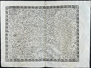
Regional Maps of France (Limaniae topographia & Boloniensium Ditionis)
Published by Antwerp, 1593
Seller: Trillium Antique Prints & Rare Books, Franklin, TN, U.S.A.
Seller rating 3 out of 5 stars
Art / Print / Poster
Condition: Fine. This truly significant map is from one of the rarest atlases ever published, Gerard and Cornelis de Jode's Speculum orbis Terrae. The work was published in Antwerp in 1593 by Arnold Coninx for the widow and heirs. This is considered the second edition, revised an expanded. The first edition was published in 1578. Van Ortroy knew of only 14 copies of the second edition being published. (Skelton, Introduction to the facsimile editions)De Jode drew upon his large stock of maps from Italian, German, and Flemish cartographers to create his atlas. He engraved some of the maps and his brothers, Joannes and Lucas van Deutecum, also contributed to the process. The second edition included additional maps from Gerard's son Cornelis. The maps have descriptive text to verso in Latin. The text for the first edition was written by the German scholar, Daniel Cellarius.The atlas contained some of the most groundbreaking maps ever published. The maps of the world, Americas, Australia, and China are of particular note and remain some of the most important maps ever published. While it may not have had commercial success at the time, it is considered a masterpiece of 16th century cartography. Very few examples of the maps have survived from either edition.Gerard de Jode (1521- 1591) was a Flemish cartographer, printer, and engraver. He produced and sold many maps in Antwerp, but his legacy lies in his outstanding atlas, Speculum Orbis Terrarum. De Jode was a contemporary and competitor of Abraham Ortelius. Ortelius was believed to have been responsible for delaying de Jode's work so his atlas Theatrum Orbis Terrarum would precede de Jode's. Because Ortelius's atlas had 8 years on the market it was well established and thus de Jode's atlas did not sell very well.To compete with Ortelius, de Jode worked on the second revised and expanded edition. De Jode's wife and son, Cornelis (1568-1600) took over the publishing upon Gerard's death in 1591. Cornelis prepared ten new maps of the World, North America, China, Australia and Alaska and re-issued the atlas. "Many of de Jode�s maps are judged to be superior to those of Ortelius, both in detail and style." (Burden)Antwerp publisher Joan Baptista Vrients purchased the plates after Cornelis's death. He also acquired Ortelius's plates for Theatrum Orbis Terrarum to which he gave priority. It is likely he bought de Jode's plates to prevent any further editions of Speculum of course only increasing the intrigue and worth of the maps today."Although the atlas may not have appealed to the public, it was admired by other cartographers. As evidence, Petrus Montanus mentions it in the same breath with Mercator�s Atlas and Ortelius� Theatrum in his preface to Pieter Kaerius� Germaniae inferior (Wardington Catalogue), Michael von Aitzing refers to it in his work, DeLeone Belgico (1583). Von Aitzing intended his work to act also as a supplement to both the Theatrum of Ortelius and the Speculum of De Jode." (Burden)Provenance : Ownership inscription at the bottom of the title page ex Bibliotheca Prim d Federici 1600.References: Van der Krogt 32:02B (titles 32:2A and 32:2B) ; Koeman II, Jod 2 ; Shirley, The mapping of the world, 165,184 ; Burden, The mapping of America, 81, 82 ; Symour, L. Schwartz, Ehrenberg, The mapping of America, pp. 78-79 ; Norwich, Maps of Africa 19 ; Navari, Maps of Cyprus, 29 ; Tooley, Dictionnary of mapmakers II, p. 441 ; Tooley, Mapping of Australia,; Tooley, Arabia in early maps, 38 (1st ed.) ; Koeman, Schilder, van Egmond, van der Krogt, HOC,vol. 3 part 2, Commercial Cartography and Map Production in the Low Countries, 1500 �" ca. 1672, pp. 1321-1323 ; Ortroy, Fern van, L�oeuvre cartographique de Gerard et de Corneille de Jode, Gand 1914, 82-121. --- The work is in very good to excellent condition overall. The maps from this work are truly in remarkable condition for the age. While some faint offset or minor marks or imperfections can be expected, they generally.
-

Map of Lorraine, France (Lotharingia Ducatus)
Published by Antwerp, 1593
Seller: Trillium Antique Prints & Rare Books, Franklin, TN, U.S.A.
Seller rating 3 out of 5 stars
Art / Print / Poster
Condition: Fine. This truly significant map is from one of the rarest atlases ever published, Gerard and Cornelis de Jode's Speculum orbis Terrae. The work was published in Antwerp in 1593 by Arnold Coninx for the widow and heirs. This is considered the second edition, revised an expanded. The first edition was published in 1578. Van Ortroy knew of only 14 copies of the second edition being published. (Skelton, Introduction to the facsimile editions)De Jode drew upon his large stock of maps from Italian, German, and Flemish cartographers to create his atlas. He engraved some of the maps and his brothers, Joannes and Lucas van Deutecum, also contributed to the process. The second edition included additional maps from Gerard's son Cornelis. The maps have descriptive text to verso in Latin. The text for the first edition was written by the German scholar, Daniel Cellarius.The atlas contained some of the most groundbreaking maps ever published. The maps of the world, Americas, Australia, and China are of particular note and remain some of the most important maps ever published. While it may not have had commercial success at the time, it is considered a masterpiece of 16th century cartography. Very few examples of the maps have survived from either edition.Gerard de Jode (1521- 1591) was a Flemish cartographer, printer, and engraver. He produced and sold many maps in Antwerp, but his legacy lies in his outstanding atlas, Speculum Orbis Terrarum. De Jode was a contemporary and competitor of Abraham Ortelius. Ortelius was believed to have been responsible for delaying de Jode's work so his atlas Theatrum Orbis Terrarum would precede de Jode's. Because Ortelius's atlas had 8 years on the market it was well established and thus de Jode's atlas did not sell very well.To compete with Ortelius, de Jode worked on the second revised and expanded edition. De Jode's wife and son, Cornelis (1568-1600) took over the publishing upon Gerard's death in 1591. Cornelis prepared ten new maps of the World, North America, China, Australia and Alaska and re-issued the atlas. "Many of de Jode�s maps are judged to be superior to those of Ortelius, both in detail and style." (Burden)Antwerp publisher Joan Baptista Vrients purchased the plates after Cornelis's death. He also acquired Ortelius's plates for Theatrum Orbis Terrarum to which he gave priority. It is likely he bought de Jode's plates to prevent any further editions of Speculum of course only increasing the intrigue and worth of the maps today."Although the atlas may not have appealed to the public, it was admired by other cartographers. As evidence, Petrus Montanus mentions it in the same breath with Mercator�s Atlas and Ortelius� Theatrum in his preface to Pieter Kaerius� Germaniae inferior (Wardington Catalogue), Michael von Aitzing refers to it in his work, DeLeone Belgico (1583). Von Aitzing intended his work to act also as a supplement to both the Theatrum of Ortelius and the Speculum of De Jode." (Burden)Provenance : Ownership inscription at the bottom of the title page ex Bibliotheca Prim d Federici 1600.References: Van der Krogt 32:02B (titles 32:2A and 32:2B) ; Koeman II, Jod 2 ; Shirley, The mapping of the world, 165,184 ; Burden, The mapping of America, 81, 82 ; Symour, L. Schwartz, Ehrenberg, The mapping of America, pp. 78-79 ; Norwich, Maps of Africa 19 ; Navari, Maps of Cyprus, 29 ; Tooley, Dictionnary of mapmakers II, p. 441 ; Tooley, Mapping of Australia,; Tooley, Arabia in early maps, 38 (1st ed.) ; Koeman, Schilder, van Egmond, van der Krogt, HOC,vol. 3 part 2, Commercial Cartography and Map Production in the Low Countries, 1500 �" ca. 1672, pp. 1321-1323 ; Ortroy, Fern van, L�oeuvre cartographique de Gerard et de Corneille de Jode, Gand 1914, 82-121. --- The work is in very good to excellent condition overall. The maps from this work are truly in remarkable condition for the age. While some faint offset or minor marks or imperfections can be expected, they generally.
-
Illustration from "Speculum orbis Terrae" (1593) "De Institutione Et Ordine Imperii Germanici Tabula II"
Published by Arnold Coninx, Antwerpen, 1593
Seller: Rare Books Honolulu, Honolulu, HI, U.S.A.
Association Member: IOBA
Seller rating 5 out of 5 stars

Art / Print / Poster
n/a. Condition: Very Good. from the 2nd Edition. Antwerpen, Arnold Coninx, 1593 --- ---- This truly significant map is from one of the rarest atlases ever published, Gerard and Cornelis de Jode's Speculum orbis Terrae. The work was published in Antwerp in 1593 by Arnold Coninx for the widow and heirs. This is considered the second edition, revised and expanded. The first edition was published in 1578. Van Ortroy knew of only 14 copies of the second edition being published. (Skelton, Introduction to the facsimile editions) --- --- from the 2nd Edition, Very Good. --- --- --- --- De Jode drew upon his large stock of maps from Italian, German, and Flemish cartographers to create his atlas. He engraved some of the maps and his brothers, Joannes and Lucas van Deutecum, also contributed to the process. The second edition included additional maps from Gerard's son Cornelis. The maps have descriptive text to verso in Latin. The text for the first edition was written by the German scholar, Daniel Cellarius. The atlas contained some of the most groundbreaking maps ever published. The maps of the world, Americas, Australia, and China are of particular note and remain some of the most important maps ever published. While it may not have had commercial success at the time, it is considered a masterpiece of 16th century cartography. Very few examples of the maps have survived from either edition. Gerard de Jode (1521- 1591) was a Flemish cartographer, printer, and engraver. He produced and sold many maps in Antwerp, but his legacy lies in his outstanding atlas, Speculum Orbis Terrarum. De Jode was a contemporary and competitor of Abraham Ortelius. Ortelius was believed to have been responsible for delaying de Jode's work so his atlas Theatrum Orbis Terrarum would precede de Jode's. Because Ortelius's atlas had 8 years on the market it was well established and thus de Jode's atlas did not sell very well. To compete with Ortelius, de Jode worked on the second revised and expanded edition. De Jode's wife and son, Cornelis (1568-1600) took over the publishing upon Gerard's death in 1591. Cornelis prepared ten new maps of the World, North America, China, Australia and Alaska and re-issued the atlas. "Many of de Jode's maps are judged to be superior to those of Ortelius, both in detail and style." (Burden) Antwerp publisher Joan Baptista Vrients purchased the plates after Cornelis's death. He also acquired Ortelius's plates for Theatrum Orbis Terrarum to which he gave priority. It is likely he bought de Jode's plates to prevent any further editions of Speculum of course only increasing the intrigue and worth of the maps today. "Although the atlas may not have appealed to the public, it was admired by other cartographers. As evidence, Petrus Montanus mentions it in the same breath with Mercator's Atlas and Ortelius' Theatrum in his preface to Pieter Kaerius' Germaniae inferior (Wardington Catalogue), Michael von Aitzing refers to it in his work, DeLeone Belgico (1583). Von Aitzing intended his work to act also as a supplement to both the Theatrum of Ortelius and the Speculum of De Jode." (Burden) Provenance : Ownership inscription at the bottom of the title page ex Bibliotheca Prim d Federici 1600. References: Van der Krogt 32:02B (titles 32:2A and 32:2B) ; Koeman II, Jod 2 ; Shirley, The mapping of the world, 165,184 ; Burden, The mapping of America, 81, 82 ; Symour, L. Schwartz, Ehrenberg, The mapping of America, pp. 78-79 ; Norwich, Maps of Africa 19 ; Navari, Maps of Cyprus, 29 ; Tooley, Dictionnary of mapmakers II, p. 441 ; Tooley, Mapping of Australia,; Tooley, Arabia in early maps, 38 (1st ed.) ; Koeman, Schilder, van Egmond, van der Krogt, HOC,vol. 3 part 2, Commercial Cartography and Map Production in the Low Countries, 1500 ca. 1672, pp. 1321-1323 ; Ortroy, Fern van, L'oeuvre cartographique de Gerard et de Corneille de Jode, Gand 1914, 82-121.
-

Novae Guineae Forma and Situs.
Published by Arnold Corunx for the widow & heirs of Gerard de Jode,
Seller: Daniel Crouch Rare Books Ltd, London, United Kingdom
Association Member: ABA ILAB PBFA
Seller rating 4 out of 5 stars

Map
US$ 24,817.60
US$ 26.77 shipping
Ships from United Kingdom to U.S.A.Quantity: 1 available
Add to basketThe first map to focus on "Australia" Full-page map with contemporary hand-colour in full. "The first printed map of Australia" (Tooley), showing part of New Guinea, and a speculative Australian coastline. New Guinea was named by the Spanish explorer ��igo Ort�z de Retes in 1545, who thought that the landscape and people were similar to those of the Guinea region of Africa: the Latin text on New Guinea explains this. Australia is populated by a hunter chasing real and mythical beasts. It was still a largely unexplored part of the world, with only the reports of a few Spanish and Portuguese voyages to draw on. The text on New Guinea warns that observers are still not sure whether it is an island or continent, but calls Australia "a fifth continent", indicating an awareness of its size. The map appeared only in the second and final edition of the De Jode family atlas, the 'Speculum' in 1593, and juxtaposes "a fairly conventional treatment of New Guinea and the Solomon Islands with an unannotated southern land and seas filled with strange and mythical creatures. In this respect, it is reminiscent of the Dieppe School maps, themselves believed to owe much to now-lost Portuguese mapping. While most of the annotations, and all the accompanying text, are in Latin, several terms used are Spanish, including 'Islas de Salamon', the Solomon Islands. The representation of New Guinea has significant text, both on the map and on its reverse. Text appearing on 'Nova Guinea' explains that it was given this name by sailors because the shore was thought to be similar to that of Guinea in Africa. The mapmaker ends by stating that it is not known whether New Guinea is joined to the southern land" (Helman). The mapmakers The 'Speculum' was first published in 1578 by Gerard de Jode (1509-1591) with text by Daniel Cellarius. It was designed to compete with Abraham Ortelius' atlas, 'Theatrum Orbis Terrarum', which had been published eight years earlier. Ortelius used his influence to disrupt de Jode's application for a royal privilege. By the time this was finally granted, seven years after the publication of the 'Theatrum', Ortelius' work had become so popular that de Jode's atlas did not sell well, despite the accuracy and clarity of his maps. His son Cornelis (1558-1600) continued his father's publishing business after studying at Douai. He produced an enlarged edition of the 'Speculum' in 1593, which Gerard had been planning before his death. Either Cornelis or Gerard was the first person to make a globe following the geography of Mercator in the southern hemisphere; no copies of it survive to provide evidence. Although sales of de Jode's work were less than ideal, the atlas was evidently held in high regard, with several contemporaries citing its importance alongside the atlases of Mercator and Ortelius. Few examples of either edition of the 'Speculum' have survived, making the maps within a rarity. Literature: National Library of Australia, Helman for 'Mapping our World: Terra Incognita to Australia', page 92; Schilder, 'Australia Unveiled', 13, image page 269; Suarez, 'Early Mapping of the Pacific', pages 60-61; Tooley, 'Landmarks of Mapmaking', page 247; Tooley, Mapping of Australia, 385.
-
Hemispheriu ab Aequinoctiali Linea ad Circulu Poli Arctici. Hemispheriu ab Aequinoctiali Linea, ad Circulu Poli Atarctici.
Published by Arnold Corunx for the widow & heirs of Gerard de Jode,
Seller: Daniel Crouch Rare Books Ltd, London, United Kingdom
Association Member: ABA ILAB PBFA
Seller rating 4 out of 5 stars
Map
US$ 55,150.22
US$ 26.77 shipping
Ships from United Kingdom to U.S.A.Quantity: 1 available
Add to basketDe Jode's striking world map on a north and south polar projection Double-page engraved map. One of the two new world maps published in the final edition of De Jode's 'Speculum' in 1593. The present map is extremely distinctive, drawn as two hemispheres on North and South polar projections, a style rarely used by sixteenth century cartographers. Drawing on a range of sources, particularly Guillaume Postel's 1581 'Polo Aptata Nova Charta Universi' and an anonymous set of gores from c1587, De Jode's map demonstrates not only the wealth of geographical insight generated by early European exploration, but also the limits of contemporary knowledge. On the one hand, the Northern hemisphere presents the continents of Europe, Asia, Africa and North America in great detail. The cartography is generally accurate, most major cities are named and relief is shown pictorially. On the other hand, however, India is shaped quite irregularly, and several of the south-east Asian islands are incorrect, either in name or in location. Similarly, while the American coast is well-drawn, the continent lacks many details, having not yet been thoroughly explored and mapped. It also contains a few mythical cities, such as Quivira and Civola. Similarly, although the land shown around the circumference of the Southern hemisphere is generally accurate, the second half of the map is dominated by the evidently erroneous 'Terra Australis Incognita'. As a result of the polar hemisphere projection, the land closest to the Equator has been compressed; consequently, there appears to be little space between Asia and America, with Japan equidistant between the two continents. The map appeared in the last edition of the de Jodes' atlas 'Speculum orbis terrae'. The 'Speculum' was first published in 1578 by Gerard de Jode (1509-1591) with text by Daniel Cellarius. It was designed to compete with Abraham Ortelius' atlas, 'Theatrum Orbis Terrarum', which had been published eight years earlier. Ortelius had used his influence to disrupt de Jode's application for a royal privilege. By the time this was finally granted, seven years after the publication of the 'Theatrum', Ortelius' work had become so popular that de Jode's atlas did not sell well, despite the accuracy and clarity of his maps. His son Cornelis (1558-1600) continued his father's publishing business after studying at Douai. He produced an enlarged edition of the 'Speculum' in 1593, which Gerard had been planning before his death. The present map appeared for the first time in that edition, along with another world map (Shirley 165). The individual maps may have been issued separately without text, prior to the publication of the atlas. Although sales of de Jode's work were less than ideal, the atlas was evidently held in high regard, with several contemporaries citing its importance alongside the atlases of Mercator and Ortelius. Few examples of either edition of the 'Speculum' have survived, making the maps within a rarity. Literature: Shirley, 'The mapping of the world: early printed world maps, 1472-1700', 184.
-
![Seller image for Novae Guineae Formus and Situs; Quivirae Regnu[m], cum alijs versus Borea[lem] for sale by Daniel Crouch Rare Books Ltd](https://pictures.abebooks.com/inventory/md/md31936710104.jpg)
Novae Guineae Formus and Situs; Quivirae Regnu[m], cum alijs versus Borea[lem]
Published by Arnold Corunx for the widow & heirs of Gerard de Jode,, Antwerp,, 1593
Seller: Daniel Crouch Rare Books Ltd, London, United Kingdom
Association Member: ABA ILAB PBFA
Seller rating 4 out of 5 stars
US$ 24,817.60
US$ 26.77 shipping
Ships from United Kingdom to U.S.A.Quantity: 1 available
Add to basketThe first printed map of Alaska and the first map to focus on "Australia" Two engraved maps on a double-page mapsheet. Two seminal maps of the Pacific: the earliest map focused on Alaska, the Northwest and upper California, and "the first printed map of Australia" (Tooley). In the map of North America the west coast is reasonably well delineated, and de Jode has chosen to include the mythical Strait of Anian separating America from Asia. The existence of a body of water between the two continents had been suggested but not proved when the map was made. Despite the channel between the continents, the figures populating America are outside tents and domed buildings which are distinctly Asian in appearance. It was widely believed that America was first settled by migrants from Asia, as confirmed by an inscription on the map comparing Native Americans to Tartars. De Jode obscures the lack of internal geographical knowledge of the continent with two large strategically placed cartouches. At the top of the map are four imaginary islands. Mercator believed that four great rivers ran into a central whirlpool between these four islands. The magnetic north pole is marked by the edge of a black rock at the left edge of the map, which supposedly stood between the islands. The map of Australasia shows part of New Guinea, and a speculative Australian coastline. New Guinea was named by the Spanish explorer ��igo Ort�z de Retes in 1545, who thought that the landscape and people were similar to those of the Guinea region of Africa: the Latin text on New Guinea explains this. Australia is populated by a hunter chasing real and mythical beasts. It was still a largely unexplored part of the world, with only the reports of a few Spanish and Portuguese voyages to draw on. The text on New Guinea warns that observers are still not sure whether it is an island or continent, but calls Australia "a fifth continent", indicating an awareness of its size. The two maps are rare, with only one known state. They appeared only in the second and final edition of the 'Speculum' in 1593. The 'Speculum' was first published in 1578 by Gerard de Jode (1509-1591) with text by Daniel Cellarius. It was designed to compete with Abraham Ortelius' atlas, 'Theatrum Orbis Terrarum', which had been published eight years earlier. Ortelius used his influence to disrupt de Jode's application for a royal privilege. By the time this was finally granted, seven years after the publication of the 'Theatrum', Ortelius' work had become so popular that de Jode's atlas did not sell well, despite the accuracy and clarity of his maps. His son Cornelis (1558-1600) continued his father's publishing business after studying at Douai. He produced an enlarged edition of the 'Speculum' in 1593, which Gerard had been planning before his death. Either Cornelis or Gerard was the first person to make a globe following the geography of Mercator in the southern hemisphere; no copies of it survive to provide evidence. Although sales of de Jode's work were less than ideal, the atlas was evidently held in high regard, with several contemporaries citing its importance alongside the atlases of Mercator and Ortelius. Few examples of either edition of the 'Speculum' have survived, making the maps within a rarity. Burden 82. For 'Quivirae Regnu[m]', see Falk, Alaskan Maps, 1593-2, p.14, xiii; Rey, Unveiling the Arctic, p.565; Wagner, Northwest Coast of America, no. 171, p.104. For 'Novae Guinea', see Allen, p.60-61; Harris, p.125; NLA, p.92; Schilder 13, ill. p.269; Suarez, p.60-61; Tooley, Landmarks of Mapmaking, p.247; Tooley, Mapping of Australia, 385. (Australia) 330 by 210mm (13 by 8.25 inches). (Alaska) 340 by 230mm (13.5 by 8,.75 inches).
-

Totius Orbis Cogniti Universalis Descriptio Cui etiam eandem orbis terrae delineationem, duorum circulorum capacitate huius descriptionis mundi longitudinem documento admirantibus adiecimus anno MDLXXXIX.
Published by Gerard de Jode, 1593]., [Antwerp,, 1593
Seller: Daniel Crouch Rare Books Ltd, London, United Kingdom
Association Member: ABA ILAB PBFA
Seller rating 4 out of 5 stars
US$ 33,090.13
US$ 26.77 shipping
Ships from United Kingdom to U.S.A.Quantity: 1 available
Add to basketDe Jode's rare world map Double-page engraved map. A map of the world by Cornelis de Jode and published by his father, Gerard. The map shows two views of the world. The main chart is a world map on a rectangular projection. Points of interest include the portrayal of the gigantic southern continent 'Terra Australis', believed to represent the rest of the landmass implied by the passage of Tierra del Fuego, reaching up to near New Guinea. The South American continent is disproportionately wide. The Strait of Anian separates America and Asia. The two small hemispheric maps to either side of the title show the western and eastern hemispheres on Roger Bacon's circular projection. The imprint at the lower edge states that the map was created by Cornelis de Jode in November 1589 at the Academy of Douai, and published or printed by his father Gerard de Jode. The map appeared in the second edition of the de Jodes' atlas 'Speculum orbis terrae'. The 'Speculum' was first published in 1578 by Gerard de Jode (1509-1591) with text by Daniel Cellarius. It was designed to compete with Abraham Ortelius' atlas, 'Theatrum Orbis Terrarum', which had been published eight years earlier. Ortelius used his influence to disrupt de Jode's application for a royal privilege. By the time this was finally granted, seven years after the publication of the 'Theatrum', Ortelius' work had become so popular that de Jode's atlas did not sell well, despite the accuracy and clarity of his maps. His son Cornelis (1558-1600) continued his father's publishing business after studying at Douai. He produced an enlarged edition of the 'Speculum' in 1593, which Gerard had been planning before his death. Either Cornelis or Gerard was the first person to make a globe following the geography of Mercator in the southern hemisphere; no copies of it survive to provide evidence. Although sales of de Jode's work were less than ideal, the atlas was evidently held in high regard, with several contemporaries citing its importance alongside the atlases of Mercator and Ortelius. Few examples of either edition of the 'Speculum' have survived, making the maps within a rarity. van der Krogt 0001:32B; Shirley 165.
-
Map of part of Germany
Published by Antwerp, 1593
Seller: Trillium Antique Prints & Rare Books, Franklin, TN, U.S.A.
Seller rating 3 out of 5 stars
Art / Print / Poster
Condition: Fine. This truly significant map is from one of the rarest atlases ever published, Gerard and Cornelis de Jode's Speculum orbis Terrae. The work was published in Antwerp in 1593 by Arnold Coninx for the widow and heirs. This is considered the second edition, revised an expanded. The first edition was published in 1578. Van Ortroy knew of only 14 copies of the second edition being published. (Skelton, Introduction to the facsimile editions)De Jode drew upon his large stock of maps from Italian, German, and Flemish cartographers to create his atlas. He engraved some of the maps and his brothers, Joannes and Lucas van Deutecum, also contributed to the process. The second edition included additional maps from Gerard's son Cornelis. The maps have descriptive text to verso in Latin. The text for the first edition was written by the German scholar, Daniel Cellarius.The atlas contained some of the most groundbreaking maps ever published. The maps of the world, Americas, Australia, and China are of particular note and remain some of the most important maps ever published. While it may not have had commercial success at the time, it is considered a masterpiece of 16th century cartography. Very few examples of the maps have survived from either edition.Gerard de Jode (1521- 1591) was a Flemish cartographer, printer, and engraver. He produced and sold many maps in Antwerp, but his legacy lies in his outstanding atlas, Speculum Orbis Terrarum. De Jode was a contemporary and competitor of Abraham Ortelius. Ortelius was believed to have been responsible for delaying de Jode's work so his atlas Theatrum Orbis Terrarum would precede de Jode's. Because Ortelius's atlas had 8 years on the market it was well established and thus de Jode's atlas did not sell very well.To compete with Ortelius, de Jode worked on the second revised and expanded edition. De Jode's wife and son, Cornelis (1568-1600) took over the publishing upon Gerard's death in 1591. Cornelis prepared ten new maps of the World, North America, China, Australia and Alaska and re-issued the atlas. "Many of de Jode�s maps are judged to be superior to those of Ortelius, both in detail and style." (Burden)Antwerp publisher Joan Baptista Vrients purchased the plates after Cornelis's death. He also acquired Ortelius's plates for Theatrum Orbis Terrarum to which he gave priority. It is likely he bought de Jode's plates to prevent any further editions of Speculum of course only increasing the intrigue and worth of the maps today."Although the atlas may not have appealed to the public, it was admired by other cartographers. As evidence, Petrus Montanus mentions it in the same breath with Mercator�s Atlas and Ortelius� Theatrum in his preface to Pieter Kaerius� Germaniae inferior (Wardington Catalogue), Michael von Aitzing refers to it in his work, DeLeone Belgico (1583). Von Aitzing intended his work to act also as a supplement to both the Theatrum of Ortelius and the Speculum of De Jode." (Burden)Provenance : Ownership inscription at the bottom of the title page ex Bibliotheca Prim d Federici 1600.References: Van der Krogt 32:02B (titles 32:2A and 32:2B) ; Koeman II, Jod 2 ; Shirley, The mapping of the world, 165,184 ; Burden, The mapping of America, 81, 82 ; Symour, L. Schwartz, Ehrenberg, The mapping of America, pp. 78-79 ; Norwich, Maps of Africa 19 ; Navari, Maps of Cyprus, 29 ; Tooley, Dictionnary of mapmakers II, p. 441 ; Tooley, Mapping of Australia,; Tooley, Arabia in early maps, 38 (1st ed.) ; Koeman, Schilder, van Egmond, van der Krogt, HOC,vol. 3 part 2, Commercial Cartography and Map Production in the Low Countries, 1500 �" ca. 1672, pp. 1321-1323 ; Ortroy, Fern van, L�oeuvre cartographique de Gerard et de Corneille de Jode, Gand 1914, 82-121. --- The work is in very good to excellent condition overall. The maps from this work are truly in remarkable condition for the age. While some faint offset or minor marks or imperfections can be expected, they generally.
-
Germania Inferior. Gallia Belgica Dicta, continens Hispaniarum Regis Provincias Septentrionales.
Published by De Jode Cornelis, Antwerp 1593, 1593
Seller: Sanderus Antiquariaat, Gent, Belgium
Association Member: ILAB
Seller rating 4 out of 5 stars
Map
No Binding. Condition: Fine. XVII Provinces, by Cornelis de Jode, 1593. Contemporary colored. A rare and beautiful map of the Low Countries. Size (not including margins): 345 x 434mm (13.58 x 17.09 inches). From: Speculum Orbis Terrae. Antwerpen, G. De Jode, 1593. (Van der Krogt 3, 2:02.
-
Brasilia et Peruvia
Published by De Jode Cornelis, Antwerp 1593, 1593
Seller: Sanderus Antiquariaat, Gent, Belgium
Association Member: ILAB
Seller rating 4 out of 5 stars
Map
No Binding. Condition: Fine. Beautiful contemporary coloured map of South America. A rare map. Some offsetting, else perfect condition. Size: engraving 36 x 42.5cm (14 x 16.6 inches), paper: 46 x 59,8 cm. From: Speculum Orbis Terrae. Antwerpen, G. De Jode, 1593. (Van der Krogt 3, 2:02).
-

Quivirae Regnu, cum alijs versus Borea. (California)
Published by Cornelis de Jode, Antwerp, 1593
Seller: Leen Helmink Antique Maps, Huntington Beach, CA, U.S.A.
Association Member: ILAB
Seller rating 4 out of 5 stars
Map
No Binding. Condition: Fine. Cornelis de Jode's epic map of the westcoast of North America, from latitude 30 degrees N all the way to latitude 90 degrees N, close to the North Pole. The map covers all of today's western US, western Canada and Alaska. The Tropic of Cancer (latitude 23 degrees 26') is given near the bottom of the map, and the Arctic Circle (latitude 66 degress 33') is present also, about two-thirds up the map. This is the first map dedicated to this region, and it is a fascinating amalgamation of Marco Polo's account of his travels to China, and the early California coast explorations of the Spanish Pacific explorers, up to and beyond C. de S. Francisco and Mendocino. The Sierra Nevada (Snowy Mountains) is noted, first named in 1542 by Juan Rodriguez Cabrillo for one of the few inland features that could clearly be seen from the Spanish explorers ships. America is separated from Asia by the undiscovered but correctly assumed El Streto de Anian (Anian Strait), a hypothesis first introduced by Giacomo Gastaldi and later adopted by Gerard Mercator. The Arctic islands in the far north also go back to Mercator, who relied on a famous but lost work of the 1360s known as Inventio Fortunata, containing a description of the North Pole as a magnetic island surrounded by a giant whirlpool and four islands. The book was a travel account by a Franciscan friar from Oxford who made half a dozen of journeys to the far north on behalf of the King of England (Edward III). The Inventio had already gone missing in Mercator's days, but he had access to a summary of it by Jacob Cnoyen, a traveller from Brabant, as Mercator writes in a letter to the English astronomer John Dee in 1577. The Cnoyen summary also went missing soon after. In the upper left is a rock representing the Magnetic Pole, which explains the deviation of the compass. It "respects the Cape Verdian Islands", where the deviation was known to be zero, meaning the magnetic pole had to be on the same or opposite meridian. Two sea monsters are in the Pacific, as well as a galley and two caravels, copied after designs by Pieter Bruegel the Elder. Interestingly, the tent dwellers depicted inland are probably the first printed depiction of north American natives in this part of the world. "Like the Americae Pars Borealis this single sheet map is largely derived from the eighteen sheet world map by Petrus Plancius of 1592. It is the first published map devoted to the west and north-west coasts of North America, and comes from de Jode's very rare atlas entitles Speculum Orbis Terrae. It depicts the west coast from below the Tropic of Cancer to the North Pole here represented by the top border of the map. Part of the four islands derived from Mercator surrounds the pole. Belows this runs the western end of the North West Passage leading into the El Streto de Anian. At this point we find the legend Polus Magnetis respectu insularu Capitis Viridis, and early indication of the magnetic pole. The map couples perfectly with the map Americae Pars Borealis to complete the coverage of North America. The inland details largely reflect the extent of various beliefs and legends that existed at the time; only part of the coastline records first hand knowledge. It is beautifully adorned with mythical sea creatures and ships. Being issued in only one edition the map is very rare. There is only one known state of it." (Burden 82). Gerard de Jode originally issued his atlas in 1578 to compete with Ortelius' atlas with little success. In 1593, two years after his death, Gerard's son Cornelius re-issued the atlas. The success of the atlas was very limited due to heavy competition with Ortelius, who also seems to have bought many copies of de Jode's atlas to take them off the market. Because of this, both editions of the de Jode atlas are exceptionally rare. "Gerard de Jode, born in Nijmegen, was a cartographer, engraver, printer and publisher in Antwerp, issueing maps from 1555 more or less in the same period as.
-

Novae Guineae Forma & Situs (Australia)
Published by Cornelis de Jode, Antwerp, 1593
Seller: Leen Helmink Antique Maps, Huntington Beach, CA, U.S.A.
Association Member: ILAB
Seller rating 4 out of 5 stars
Map
No Binding. Condition: Fine. "This map appeared for the first time in the second edition of de Jode's atlas Speculum Orbis Terrae, Antverpiae. 1593. Though the map is entitled Novae Gvineae, only the upper part shows New Guinea: the lower section shows a wholly imaginative mountainous, Australian north-coast. On it is depicted a dramatic encounter between a hunter, armed with bow and arrows, and a griffon, a lion and a snake. In a way, this can be called the first printed map of Australia. The legend on New Guinea, apart from repeating the old complaint that it is not known whether it is an island or part of a continent, states: 'New Guinea is so called by the sailors because those coasts, the nature of the country, are similar to the African Guinea.' The matter of New Guinea and the south-land is taken up even more extensively in the text of the atlas (fol. 12v): 'This region is even today almost unknown, because after the first and second voyages all have avoided sailing thither so that it is doubtful even until today whether it is a continent or an island. The sailors called this region New Guinea because its coasts, state and conditions are similar in many respects to the African Guinea. Andreas Consalius seems to call it Peccinacolij. After this region the huge Australian land follows which - as soon as it is once known - will represent a fifth continent, so vast and immense is it deemed. In the east the Salomon Islands join up, in the north the S. Lazarus Archipelago; it also takes its beginning at two or three degrees south of the equator. In the west it is, if not an island, connected up with the Australian continent.' " (Schilder). "De Jode's rare map of New Guinea and Terra Australis Incognita is considered by some authorities to represent the first printed map of Australia. One of the remaining contentious issues on the history of the discovery of Australia is whether or not the Dutch were the first European nation to land on Australian soil. Many argue that it was indeed the Portuguese who landed first. Some say it was a little known French voyage that should claim the prize. De Jode's extraordinary map, showing New Guinea, the Salomon Islands and a large fictitious northern Australia, is frequently used to illustrate knowledge of Australia prior to the Dutch landing on the west coast of Cape York Peninsula in 1606. Tooley notes, 'It may be called the first map of Australia', while Schilder states, 'In a way, this can be called the first printed map of Australia'. Certainly the accompanying text lends weight to this viewpoint. The text from the atlas states . 'After this region, the huge Australian land follows which - as soon as it is known - will represent a fifth continent .' As with Montanus' map [of the world], the depiction of an 'Australian landmass' here probably represents no more than the charting of the tip of 'Terra Australis Incognita'. Such a portrayal of the Southland can be seen on the 1570 world map by Ortelius. De Jode's map does however hold a significant place in the history of the charting of Australia. The map is decorated with sea monsters, mermaids and ships. The large southern mainland is resplendent with a lion, griffin and a spear-hurling warrior. Gerard originally issued his atlas in 1578 to compete with Ortelius' atlas with little success. In 1593, two years after his death, Gerard's son Cornelius re-issued the atlas. This map first appeared in that posthumous edition and appears on the same sheet as 'Quivirae Regnum'." (Dewez). Gerard de Jode originally issued his atlas in 1578 to compete with Ortelius' atlas with little success. In 1593, two years after his death, Gerard's son Cornelius re-issued the atlas. The success of the atlas was very limited due to heavy competition with Ortelius, who also seems to have bought many copies of de Jode's atlas to take them off the market. Because of this, both editions of the de Jode atlas are exceptionally rare. "Gerard de Jode, born in Nijmegen, was a cartographer, engraver.
-

Brasilia et Peruvia.
Published by Antwerp,, 1593
Seller: Daniel Crouch Rare Books Ltd, London, United Kingdom
Association Member: ABA ILAB PBFA
Seller rating 4 out of 5 stars
Map
US$ 20,681.33
US$ 26.77 shipping
Ships from United Kingdom to U.S.A.Quantity: 1 available
Add to basketDe Jode's map of South America in original colour Double page engraved map, fine original hand colour. A fine original colour example of de Jode's second map of South America. The map shows part of Central America and the whole of South America, including a large landmass representing the Tierra del Fuego merging into Australia. It is one of the earliest maps to show the continent on its own, and the earliest Dutch map of South America. The Southern American continent's interior is densely detailed with many place names, annotations and images describing the territory, its people, and the flora and the fauna. Two vignettes show life at a cannibal's campsite, including a human-based dinner, and a battle between indigenous people armed with bows and arrows and explorers armed with rifles. The seas are filled with several vessels, boats, monsters, and more annotations. The map appeared in the second edition of the de Jodes' atlas 'Speculum orbis terrae'. The 'Speculum' was first published in 1578 by Gerard de Jode (1509-1591) with text by Daniel Cellarius. It was designed to compete with Abraham Ortelius' atlas, 'Theatrum Orbis Terrarum', which had been published eight years earlier. Ortelius used his influence to disrupt de Jode's application for a royal privilege. By the time this was finally granted, seven years after the publication of the 'Theatrum', Ortelius' work had become so popular that de Jode's atlas did not sell well, despite the accuracy and clarity of his maps. His son Cornelis (1558-1600) continued his father's publishing business after studying at Douai. He produced an enlarged edition of the 'Speculum' in 1593, which Gerard had been planning before his death. This map was produced specifically for the second edition. Either Cornelis or Gerard was the first person to make a globe following the geography of Mercator in the southern hemisphere; no copies of it survive to provide evidence. Although sales of de Jode's work were less than ideal, the atlas was evidently held in high regard, with several contemporaries citing its importance alongside the atlases of Mercator and Ortelius. Few examples of either edition of the 'Speculum' have survived, making the maps within a rarity. Van der Krogt 9800:32B.
-

Totius Orbis Cogniti Universalis Descriptio Cui etiam eandem orbis terrae delineationem, duorum circulorum capacitate huius descriptionis mundi longitudinem documento admirantibus adiecimus anno MDLXXXIX.
Published by Gerard de Jode, 1593]., [Antwerp,, 1593
Seller: Daniel Crouch Rare Books Ltd, London, United Kingdom
Association Member: ABA ILAB PBFA
Seller rating 4 out of 5 stars
Map
US$ 33,090.13
US$ 26.77 shipping
Ships from United Kingdom to U.S.A.Quantity: 1 available
Add to basketDe Jode's rare world map Double-page engraved map. A map of the world by Cornelis de Jode and published by his father, Gerard. The map shows two views of the world. The main chart is a world map on a rectangular projection. Points of interest include the portrayal of the gigantic southern continent 'Terra Australis', believed to represent the rest of the landmass implied by the passage of Tierra del Fuego, reaching up to near New Guinea. The South American continent is disproportionately wide. The Strait of Anian separates America and Asia. The two small hemispheric maps to either side of the title show the western and eastern hemispheres on Roger Bacon's circular projection. The imprint at the lower edge states that the map was created by Cornelis de Jode in November 1589 at the Academy of Douai, and published or printed by his father Gerard de Jode. The map appeared in the second edition of the de Jodes' atlas 'Speculum orbis terrae'. The 'Speculum' was first published in 1578 by Gerard de Jode (1509-1591) with text by Daniel Cellarius. It was designed to compete with Abraham Ortelius' atlas, 'Theatrum Orbis Terrarum', which had been published eight years earlier. Ortelius used his influence to disrupt de Jode's application for a royal privilege. By the time this was finally granted, seven years after the publication of the 'Theatrum', Ortelius' work had become so popular that de Jode's atlas did not sell well, despite the accuracy and clarity of his maps. His son Cornelis (1558-1600) continued his father's publishing business after studying at Douai. He produced an enlarged edition of the 'Speculum' in 1593, which Gerard had been planning before his death. Either Cornelis or Gerard was the first person to make a globe following the geography of Mercator in the southern hemisphere; no copies of it survive to provide evidence. Although sales of de Jode's work were less than ideal, the atlas was evidently held in high regard, with several contemporaries citing its importance alongside the atlases of Mercator and Ortelius. Few examples of either edition of the 'Speculum' have survived, making the maps within a rarity. van der Krogt 0001:32B; Shirley 165.
-
China Regnum
Published by Cornelis de Jode, Antwerp, 1593
Seller: Leen Helmink Antique Maps, Huntington Beach, CA, U.S.A.
Association Member: ILAB
Seller rating 4 out of 5 stars
Map First Edition
No Binding. Condition: Fine. 1st Edition. One of the rarest, most sought-after, and most decorative early maps of China. Double-page engraved map, the corners decorated with vignettes, two pages of Latin text describing China on verso. A pristine example of an important and distinctive map, seminal to any China collection. Only the second maps of China printed in Europe. While all of De Jode's maps are rare, this one is even more so, as it appeared in only one single 1593 edition of the De Jode atlas Speculum Orbis Terrae" (Mirror of the World). The map is based on the work of the Portuguese Jorge de Barbuda, whose map of China first appeared in the work of Cornelius de Jode's competitor Abraham Ortelius in 1584. Although this map is derived from the Jorge de Barbuda model, it has been significantly updated with the latest European discoveries. The map has been recast in a north-south orientation, and the view shifted north to show north-eastern Tartary and inner Asia. The new information is mainly derived from Jesuit sources like Giovanni Pietro de Maffei, although de Jode also acknowledges the author Juan Gonz�lez de Mendoza as source for the map. While well regarded by scholars today, De Jode's atlas was commercially no match for Ortelius's. This edition was to be the last: after the death of Cornelis in 1600 the plates were bought by Joan Baptista Vrientius, then the owner of the Ortelius plates, merely to suppress them. Copperplate engraving. Size of printed area 36.5 x 45 cms. In perfect collector's condition. Thick paper, with wide margins all around. In attractive hand coloring. Paper color off-white/ivory with no browning. From the 1593 first and only edition. The item comes with a certificate of authenticity and elaborate description. For more details and scans please contact or visit us.
-

China Regnum
Published by Collectore Cornelio de Iudeis, [1593]., Antwerp,, 1593
Seller: Daniel Crouch Rare Books Ltd, London, United Kingdom
Association Member: ABA ILAB PBFA
Seller rating 4 out of 5 stars
Map
US$ 38,605.16
US$ 26.77 shipping
Ships from United Kingdom to U.S.A.Quantity: 1 available
Add to basketDe Jode's rare map of eastern Asia Double-page engraved map with hand colour. A superb example of de Jode's map of eastern Asia, showing Japan, China and Korea, produced especially for the 1593 edition of the 'Speculum'. The map is based upon the work of the Portuguese cartographer Luiz Jorge de Barbuda, whose map of China also appeared in the work of de Jode's competitor, Abraham Ortelius, in 1584. The circular map is framed by elaborate strap-work and three vignettes of Chinese life, calculated to appeal to European interest. At the upper left corner is a fisherman working with the aid of a cormorant, a practice that continues in rural China; at the upper right there is a houseboat with a pen attached to the side. The lower right vignette is of a cart with a sail attached, the Chinese windcarts that fascinated European observers. The final image is of India, showing two people in Eastern dress worshipping a triple-headed god. The map appeared in the second edition of the de Jodes' atlas 'Speculum orbis terrae'. The 'Speculum' was first published in 1578 by Gerard de Jode (1509-1591) with text by Daniel Cellarius. It was designed to compete with Abraham Ortelius' atlas, 'Theatrum Orbis Terrarum', which had been published eight years earlier. Ortelius used his influence to disrupt de Jode's application for a royal privilege. By the time this was finally granted, seven years after the publication of the 'Theatrum', Ortelius' work had become so popular that de Jode's atlas did not sell well, despite the accuracy and clarity of his maps. His son Cornelis (1558-1600) continued his father's publishing business after studying at Douai. He produced an enlarged edition of the 'Speculum' in 1593, which Gerard had been planning before his death. Either Cornelis or Gerard was the first person to make a globe following the geography of Mercator in the southern hemisphere; no copies of it survive to provide evidence. Although sales of de Jode's work were less than ideal, the atlas was evidently held in high regard, with several contemporaries citing its importance alongside the atlases of Mercator and Ortelius. Few examples of either edition of the 'Speculum' have survived, making the maps within a rarity. van der Krogt 8410:32.
-
Theatrum principum. Extra illustrated. First edition. ( From the Collection of Paul F�lixBeuvain de Beaus�jour, Bishop of Carcassonne.)
Published by Antwerp: Circa 1651, 1651
Seller: Wittenborn Art Books, San Francisco, CA, U.S.A.
Seller rating 5 out of 5 stars
Art / Print / Poster
Condition: Good. Large 8vo. 17 x 23.5. Contemporary marbled roan, spine repaired.Unique copy with 68 17th portraits after Van Dyck, Rubens et al. with 5 additional rare 18th century engravings, including two fold-outs entitled "Arriv�e de notre St. P�re le Pape en France , l'an 1799" and a large format portrait of the celebrated monk Benoit Joseph Labre and others. The plates are pasted on support pages with extensive 18th Century manuscript annotations on facing pages. Also included are 2 Als, likely from the bishop dated 23 and 26 juin 1929 from "le Mont. " They are addressed to Henri with greetings to Madame Beaus�jour, who may have been his brother or cousin. Expertise by: Jean Lequoy, Librairie Giraud-Badin, Paris. The portraits are afterAegidius Rucholle, Titian, Anthony van Dyck, Pieter van Mol, Otto Vaenius, Rubens, Cornelis Galle, Cornelis de Vos, Gaspar de Crayer, Coenraerd Waumans, Charles Woutier, FranciscusNys and T. Willebroorts Bossaerts.Hollstein, Dutch &Flemish, Engravers, IX, pp. 212-219; OCLC Number: 2337084.Paul F�lix Beuvain de Beaus�jour, n� le 16 d�cembre 1839 � Vesoul et d�c�d� le4 avril 1930 � Carcassonne, est un pr�tre fran�ais qui fut �v�que de Carcassonne.[DE JODE (Pieter)]. Theatrum principium. S.l.n.d. Manuscrit du XVIIIe si�cle. In-4, basane marbr�e, dos orn�, roulette sur les coupes, tranches mouchet�es (Reliure de l'�poque).Important recueil de portraits grav�s de rois, princes et autres personnages illustres, grav�s et publi�s pour la plupart par Pieter de Jode le Jeune (1606-1674).Le volume renferme 73 gravures contrecoll�es et accompagn�es de notices manuscrites, dont 68 portraits, ex�cut�s pour l'essentiel au XVIIe si�cle. Il s'ouvre sur un titre-frontispice libell� Theatrum principium et s'ach�ve par une table manuscrite.De la biblioth�que Paul-F�lix Beuvain de Beaus�jour, �v�que de Carcassonne, avec ex-libris. Dos restaur�.
-
Secundae Partis Asiae [.].
Published by Antwerp, 1593., 1593
Seller: Antiquariat INLIBRIS Gilhofer Nfg. GmbH, Vienna, A, Austria
Association Member: ILAB PADA VDA VDAO
Seller rating 5 out of 5 stars
First Edition
20 x 13 inches. Hand-coloured. Fine example of De Jode's modern map of the Middle East, from his Speculum Orbis Terrae, published in Antwerp in 1578 and engraved by Joannes & Lucas van Deutecum. The complete title reads: "Secundae partis Asiae: typus qua oculis subijciuntur itinera nautarum qui Calecutium Indiae mercandorum aromatum caufa fre quentant, ac eorum quoqz qui terrestri itinere ade unt Suacham, Laccam, in domino Praeto Iani, nec non eorum qui Aden et ormum inuifunt, et Balsaram quoque castrum, supra Euphratem fluuium situm, omnia suis gradibus subiecta, cum longitudinis tum latitudinis / Iacobo Castaldo pedemontano authore; Gerhardus de Iode excudebat". As noted in the title, the map was prepared by Gerard De Jode and is largely identical to Giacomo Gastaldi's highly influential map of 1559. De Jode's delineation of Arabia is vastly superior to the contemporary maps of Ortelius, showing far more accuracy and detail. Extending from the Nile to Afghanistan and centered on the Arabian Peninsula and the Gulf, the map depicts what was then still among the most important trading centers of the commercial world. The present example is from the first edition of De Jode's work, which can be distinguished from the second edition by the pagination on the verso (VII for the 1578 edition; 9 for the 1593 edition). The map is drawn from the rare first edition of De Jode's Speculum Orbis Terrarum. At least one commentator has opined that as few as 11 examples of the first edition are known to have survived, making separate maps from this first edition very rare on the market. - Giacomo Gastaldi (fl. 1542-1565) is widely considered the most important and influential of all of the Lafreri School mapmakers. Born in Piedmont, Gastaldi worked in Venice, where he become Cosmographer to the Venetian Republic. Karrow described him as "one of the most important cartographers of the sixteenth century. He was certainly the greatest Italian mapmaker of his age". While his achievement is obvious, it is hard to quantify. A large number of maps were published throughout this period with the geography credited to Gastaldi, but it is often difficult to know what role Gastaldi played in their creation. As a practice, he did not sign himself as publisher, although his name may be found in the title, dedication, or text to the reader. Frequently where there is no imprint one may assume that Gastaldi was the publisher. A further clue may be that many of the maps attributable to Gastaldi as publisher seem to have been engraved by Fabius Licinius. In other cases, where publication is credited to another, it is not always certain whether Gastaldi was commissioned by the publisher to compile the map, whether another less-enterprising publisher merely copied his work and attribution, or simply added Gastaldi's name in the title to add authority to the delineation. His name clearly commanded the same sort of respect that the Sanson name had in the last years of the 17th century, and as Guillaume de L'Isle's had in the first half of the 18th century. Gastaldi's first published map was of Spain, engraved on four sheets, and issued in 1544. The following year he published a map of Sicily, among the most widely copied of all his maps. In the course of a prolific career, Gastaldi subsequently produced a number of maps of Italy, and individual parts of the peninsula, with his general map of Italy, and the map of Piedmont also being very influential. Among the most important of his maps, however, were of areas outside Italy. Principal among these was his map of the World, published in 1546, a four sheet map of the countries of south-eastern Europe, published in 1559, and his series of three maps of the Middle East, Southern Asia, and South-East Asia with the Far East, issued between 1559 and 1561. In 1562, Gastaldi issued a two-sheet map of the Kingdom of Poland, and in 1564, a magnificent eight-sheet map of Africa. - Karrow, Mapmakers of the Sixteenth Century, 30/.
-
Primae Partis Asiae. (Title on verso: Asiae Prima. Pars Sive Persicum Regnum).
Published by c.1593, Antwerp, 1593
Seller: Alexandre Antique Prints, Maps & Books, Toronto, ON, Canada
Seller rating 4 out of 5 stars
Map
Condition: Very Good. Latin text on verso., Size : 300x502 (mm), 11.81x19.76 (Inches), Hand Colored.
-
Quivirae Regnu, Cum Alija Versus Borea
Published by Antwerp: Arnold Coninx for Fornelis De Jode, 1593., 1593
Seller: Arader Galleries - AraderNYC, New York, NY, U.S.A.
Seller rating 5 out of 5 stars
Single sheet, float-mounted and framed (sheet size: 17 4/8 x 11 4/8 inches; framed size: 29 x 22 6/8 inches) Fine engraved map of Alaska with original hand-colour in full. This is the first printed map to show the area of Alaska, and a landmark in the mapping of the American north-west and California. Although printed on a separate sheet in the atlas, this map was intended to be contiguous with de Jode's map of North America to complete the coverage of North America in its entirety. This map reaches to the northwestern part of the American continent to the Strait of Anian, which divides North America from Asia. De Jode has adroitly placed two text cartouches to fill the space in the interior as a device to hide his lack of geographical knowledge, but the vignettes of Tartar-style figures and buildings, and accompanying text, reflect the contemporary view that the region was populated by migration from Asia. At the top of the map are four legendary islands believed to encircle the North Pole, and a strait running across the north of North America, apparently forming a navigable channel from Europe to Asia, the famous North-West Passage. Highly decorated with sea monsters and galleons, this map is appealing for both its beauty and its historical significance. Born in Nijmegen in 1509, Cornelis de Jode was a cartographer, engraver, printer and publisher based in Antwerp, then one of the major commercial capitals of Europe. Little is known of his early training or education, and it was not until well into his 30s, in 1547, that de Jode was admitted to the Guild of St. Luke and became a print seller. In 1550 he was licensed as a printer. He printed Jacopo Gastaldi's map of the world in 1555, Jacob van Deventer's map of Brabant in 1558, maps by Bartholomeus Musinus, Fernando Alvares Seco, and (before they became competitors) Abraham Ortelius's eight-sheet map of the world (1564).
-
De Quadrante geometrico libellus 1594 [Leather Bound]
Publication Date: 2025
Leather Bound. Condition: New. Presenting an Exquisite Leather-Bound Edition, expertly crafted with Original Natural Leather that gracefully adorns the spine and corners. The allure continues with Golden Leaf Printing that adds a touch of elegance, while Hand Embossing on the rounded spine lends an artistic flair. This masterpiece has been meticulously reprinted in 2025, utilizing the invaluable guidance of the original edition published many years ago in 1594. The contents of this book are presented in classic black and white. Its durability is ensured through a meticulous sewing binding technique, enhancing its longevity. Imprinted on top-tier quality paper. A team of professionals has expertly processed each page, delicately preserving its content without alteration. Due to the vintage nature of these books, every page has been manually restored for legibility. However, in certain instances, occasional blurriness, missing segments, or faint black spots might persist. We sincerely hope for your understanding of the challenges we faced with these books. Recognizing their significance for readers seeking insight into our historical treasure, we've diligently restored and reissued them. Our intention is to offer this valuable resource once again. We eagerly await your feedback, hoping that you'll find it appealing and will generously share your thoughts and recommendations. Pages:- 85, Print on Demand. If it is a multi-volume set, then it is only a single volume. We are specialised in Customisation of books, if you wish to opt different color leather binding, you may contact us. This service is chargeable. Product Disclaimer: Kindly be informed that, owing to the inherent nature of leather as a natural material, minor discolorations or textural variations may be perceptible. Explore the FOLIO EDITION (12x19 Inches): Available Upon Request. 85 85.
-
Americae Pars Borealis, Florida, Baccalaos, Canada, Corterealis.
Publication Date: 1593
Seller: Geographicus Rare Antique Maps, Brooklyn, NY, U.S.A.
Association Member: ABAA ESA ILAB
Seller rating 4 out of 5 stars
Map
Very good. Mend to bottom centerfold with some reinstated wormholing. Tallow stain to left border. Faint offsetting. Else a beautiful, full-margined example. Size 14.5 x 20 Inches. This is Cornelis De Jode's rare map of North America, printed in a single edition of 1593. The first full-size folio map specifically of North America, it was among the updated maps added to the De Jode atlas specifically to compete with Ortelius' Theatrum Orbis Terrarum . To this end, it combined cartographic information from current sources with a level of decorative flourish that had not yet appeared in any atlas. In the case of this map, Cornelis focused on a part of the world omitted from the elder De Jode's 1578 atlas. A Closer Look The map presents North America on a cylindrical projection from the Tropic of Cancer to 90� north, thus spanning from Florida, the northern Gulf Coast, and most of Baja California, well up into the Arctic; the map reaches from a highly speculative California in the west, to beyond the Canadian Maritimes in the east. Coverage extends far enough to the east to include the Azores islands and (in the north) Iceland, Greenland, and Nicolo Zeno's phantom islands of Frisland, Icaria, and Drogeo. It also features a prominent Northwest Passage. A Wealth of Descriptive Detail, Richly Embellished Cornelis understood that improved detail alone would be insufficient to challenge Ortelius' market dominance. He thus anticipated the mapmakers of the Dutch Golden Age by elaborating his maps with graphic imagery to better illustrate the relevant subject areas. Here, in the upper right, native warriors pull bows to threaten a European ship approaching the coast, cannons ablaze. In a cartouche at the lower right are six figures representing Virginian natives. An elegant dedication to the Dutch bishop Theodorus Echter is in the upper left. The map itself is beautifully engraved, with abundant pictorial forests and mountains. In addition to the finely engraved place names, De Jode includes Latin descriptions of key North American discoveries of the 16th century and descriptions of the Indigenous population. Updating the De Jode Atlas In order to produce the new continent maps for his 1593 atlas, Cornelis drew on the cartography of Peter Plancius' 1592 wall map of the world, Nova et Exacta Terrarum Orbis Tabula Geographica ac Hydrographica . The east-west distortion on each of Cornelis' new maps reflects Plancius' cylindrical projection. Plancius was a veritable clearinghouse of geographic information, so the younger De Jode's choice of source was canny. The present work thus encapsulates a unique and state-of-the-art view of the northern part of the Americas at the dawn of the European colonial era. Mapping The East Coast This is one of the first general maps to use the place name 'Virginia,' preceded only by the unobtainable Western Hemisphere maps of Hakluyt, Mazza, and Hogenberg. It is remarkable that, while the coastline and other placenames can all be found on the 1592 Plancius, that map did not include the name 'Virginia.' Its presence here indicates that De Jode was not slavishly copying Plancius and was alert to contemporary geographical developments. Also, De Jode includes a brief history of the Roanoke Colony, containing a rosy account of the region's resources: this, too, did not appear on the Plancius and is an important revision. De Jode's map is also an important Floridianum: it was the first general map to name 'St. Augustine,' preceded by only one other printed map of any kind, the 1589 Batista Boazio map. In the north (beyond a largely imaginary northeast) is a prominent St. Lawrence River, including the settlement of Hochelaga, at present-day Montreal. The river's sources lie deep within the continent, although there is no indication of the Great Lakes. Newfoundland can be recognized, termed Terra de Baccalao [Land of Cod]. The Zeno Cartography Iceland and Greenland appear at the upper right, accompanied by the phanto.
-

Hemispheriu Ab Aequinoctli Linea, Ad Circulu Poli Arctici / Hemispheriu Ad Circulu Poli Atarctici.
Publication Date: 1593
Seller: Geographicus Rare Antique Maps, Brooklyn, NY, U.S.A.
Association Member: ABAA ESA ILAB
Seller rating 4 out of 5 stars
Map
Very good. Mend to upper centerfold, not impacting image; else excellent. Size 12.5 x 20.25 Inches. This is Cornelis De Jode's rare 1593 double-polar projection map of the world. It is among the most striking early world maps and among the earliest to introduce the double hemispheric polar projection. Moreover, as a competitor to Ortelius' cartography, it is the sole obtainable map to preserve the innovative Guillaume Postel/ Antwerp Unicum cartography. The map is quite rare, having been published in only a single edition. The Sources To differentiate his map from his competitor Ortelius' Mercator-derived maps, De Jode drew on an array of sources: predominantly the 1581 world map of Guillaume Postel, and an anonymous, c. 1587 globe known as the Antwerp Unicum . To these, De Jode applied his own geographical innovations to produce a remarkably fresh work. Postel's work and the Unicum each survive in only a single confirmed example, making this De Jode map the only acquirable work to preserve their content. Postel Guillaume Postel (1510 - 1581) was a French scholar and mystic whose wide-ranging output included a world map ( Polo Aptata Nova Charta Universi ) whose polar projection was the primary influence on the present composition. A woodcut on six sheets, this map was executed by Jean de Gourmont in 1581 and survives in a sole example at the Service Historique de la Marine . Postel's geography drew heavily on the 1564 Gerard de Jode / Abraham Ortelius cordiform world map. Postel's theories on the hypothetical southern continent and his interpretations of the Arctic thus figured prominently in this, the younger De Jode's 1593 map. The Antwerp Unicum The Antwerp Unicum gained its name because of its city of composition, the absence of other surviving examples, and its anonymous maker. The Unicum consists of a full set of terrestrial globe gores, which Shirley dates c. 1587, and scholar Marcel Destombes argues were engraved in Antwerp on behalf of the De Jodes. The Unicum is assiduous in citing its sources, which include Ortelius, Thevet, and Postel. A Closer Look Double-hemisphere projections were atypical in the 16th century, and this map, employing dual polar projections, is both unique and among the earliest to adopt this convention. The hemispheres are framed with turbulent clouds, in which eight wind-heads puff furiously. The map's title is presented at the top in a pair of elegant, strapwork cartouches - the cartouche for the southern hemisphere is supported by faun-like gargoyles. Both hemispheres' oceans are neatly stippled, and the calligraphic engraving is of the highest quality, with text blocks that are sharp and legible. The southern Atlantic sports both a sea monster and a pair of sailing ships. The Arctic Islands In composing this map, De Jode likely had access to both Postel's map and the Antwerp Unicum , as it contains elements unique to each. Scrutiny of the map's presentation of Mercator's four Arctic landmasses will show, for example, that the Arctic landmass directly north of Scandinavia is conflated with the island of Nova Zembla. This appears on both precursor maps. But on the De Jode, the island falling to the east of this 'Nova Zembla' is connected to the Siberian mainland. (Despite being referred to in text as 'the best island in the whole north.') In contrast, the Postel map illustrated a conglomeration of ice floes and described an ice bridge between the mainland and the island. The Unicum shows a misinterpretation of these ice floes as an isthmus, and it is this depiction - not that of the Postel - that De Jode follows. Curiously, an ice bridge occasionally formed in this region, linking the Siberian mainland with the Lyakhovsky Islands (New Siberian Archipelago), known for its rich deposits of fossilized mammoth ivory. Although occasionally visited by trappers and fortune hunters during winter freezes, these islands were not documented until the late 18th century. American Eastern Seaboard On the o.


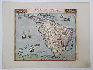
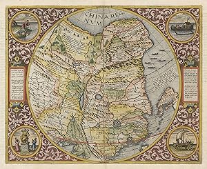

![Seller image for Secundae Partis Asiae [.]. for sale by Antiquariat INLIBRIS Gilhofer Nfg. GmbH](https://pictures.abebooks.com/inventory/md/md30296060500.jpg)
![Seller image for De Quadrante geometrico libellus 1594 [Leather Bound] for sale by Gyan Books Pvt. Ltd.](https://pictures.abebooks.com/inventory/md/md31965294564.jpg)
