Order Total (1 Item Items):
Shipping Destination:

John Golborne (5 results)
Skip to main search results
Search filters
Product Type
- All Product Types
- Books (5)
- Magazines & Periodicals (No further results match this refinement)
- Comics (No further results match this refinement)
- Sheet Music (No further results match this refinement)
- Art, Prints & Posters (No further results match this refinement)
- Photographs (No further results match this refinement)
- Maps (No further results match this refinement)
- Manuscripts & Paper Collectibles (No further results match this refinement)
Condition Learn more
- New (No further results match this refinement)
- As New, Fine or Near Fine (No further results match this refinement)
- Very Good or Good (3)
- Fair or Poor (No further results match this refinement)
- As Described (2)
Binding
- All Bindings
- Hardcover (No further results match this refinement)
- Softcover (5)
Collectible Attributes
- First Edition (3)
- Signed (No further results match this refinement)
- Dust Jacket (No further results match this refinement)
- Seller-Supplied Images (3)
- Not Print on Demand (5)
Language (1)
Price
- Any Price
- Under US$ 25 (No further results match this refinement)
- US$ 25 to US$ 50 (No further results match this refinement)
- Over US$ 50
Free Shipping
- Free Shipping to U.S.A. (No further results match this refinement)
Seller Location
Seller Rating
-
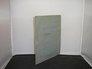
The Report of John Golborne, Engineer, Concerning the Drainage of the North Level of the Fens, and the Outfal of the Wisbeach River
Published by No Publisher, [?Chester], 1769
Seller: Zetetic Books, Berkhamsted, United Kingdom
Association Member: PBFA
Seller rating 5 out of 5 stars

First Edition
US$ 68.22
US$ 39.74 shipping
Ships from United Kingdom to U.S.A.Quantity: 1 available
Add to basketPaper Covers. Condition: Good. First Edition. [2], 3-11pp, folding map. Original paper covers. Name of Golborne in ink to upper cover (probably as issued), rubbed and lightly soiled to edges, some light browning to text, with light foxing. With a folding map engraved by Anthony Vere (fl. 1754-1778), (see Worms and Baynton-Williams, page 686), after William Elstobb. Skempton 547 Size: 4to.
-

The Report of John Golborne, Engineer, concerning the Drainage of the North Level of the Fens, and the Outfal of the Wisbeach River.
Published by Chester:, 1769
Seller: Forest Books, ABA-ILAB, Grantham, LINCS, United Kingdom
Association Member: ABA ILAB PBFA
Seller rating 5 out of 5 stars
First Edition
US$ 150.09
US$ 33.12 shipping
Ships from United Kingdom to U.S.A.Quantity: 1 available
Add to basketFirst edition, 4to, [2], 3-11, [1]pp., large fine folding map at end drawn by Mr. Elstobb, "Vere sculp. Maiden Lane Covt. Gardn.", orig. wrappers, a fine copy. The report to the General Commissioners concerning the drainage of the north level of the fens. Both Golborne and Yeoman reported on the drainage of the North Level in 1769, followed by Grundy's report of 1770. In 1773-74 Golborne served as consulting engineer when a new cut was made below Wisbeach, which was known as "Kinderley's Cut" in honour of Nathaniel Kinderley, who first proposed a scheme of this kind in 1721. By Golborne's admission, this is a preliminary report, giving an estimate of costs but not attempting to determine the course of the new channel. Kress, 6641; Goldsmith, 10586.1; Higgs, 4586; Skempton, Bibliotheca Mechanica, p.141.
-
The Report of John Golborne, Engineer, concerning the drainage of the North Level of the Fens and the Outfal of the Wisbeach River.
Published by No printer or publisher, 1769
US$ 237.41
US$ 21.20 shipping
Ships from United Kingdom to U.S.A.Quantity: 1 available
Add to basket11[1] pp, multifolding map of the River Nene and Bay from Wisbeach to the Eye taken in 1767. Contemporary blue paper wraps with 'Mr Golborne' written in ink on front wrap, sewn. 24 cm x 20 cm. Wraps soiled, minor loss to spine tips & corners, contents lightly age browned with some occasional random spotting. Skempton 547. 7 copies.
-
The Report of John Golborne, Engineer, Concerning the Drainage of the North Level of the Fens, and the Outfal of the Wisbeach River.
Publication Date: 1769
Seller: Kerr & Sons Booksellers ABA, Cartmel, CMA, United Kingdom
Seller rating 5 out of 5 stars
First Edition
US$ 68.22
US$ 39.74 shipping
Ships from United Kingdom to U.S.A.Quantity: 1 available
Add to basketSoft cover. Condition: Good. 1st Edition. Small Thin Quarto. 11pp. In light blue card covers, a previous owner has written 'Mr Golborne' to the front cover. Minor creasing and edge wear to the covers. Some light spotting to end papers. With fold out map in rear. Overall a Very Good copy.
-
US$ 88.69
US$ 33.12 shipping
Ships from United Kingdom to U.S.A.Quantity: 1 available
Add to basketSoft cover. Condition: Very Good. Small quarto pamphlet, no publication date (COPAC suggests a date of 1769), 11 pages, large folded map of the River Nene and Bay from Wisbeach to the Eye, very good condition in original paper cover, corners of covers slightly creased, text and map in fine condition, lower corner of final blank leaf folded back due to paper flaw, engineer's name written on front cover.