Order Total (1 Item Items):
Shipping Destination:

Leonard Valk (39 results)
Skip to main search results
Search filters
Product Type
- All Product Types
- Books (13)
- Magazines & Periodicals (No further results match this refinement)
- Comics (No further results match this refinement)
- Sheet Music (No further results match this refinement)
- Art, Prints & Posters (5)
- Photographs (No further results match this refinement)
- Maps (21)
- Manuscripts & Paper Collectibles (No further results match this refinement)
Condition Learn more
- New (5)
- As New, Fine or Near Fine (No further results match this refinement)
- Very Good or Good (13)
- Fair or Poor (1)
- As Described (20)
Binding
Collectible Attributes
- First Edition (No further results match this refinement)
- Signed (No further results match this refinement)
- Dust Jacket (No further results match this refinement)
- Seller-Supplied Images (29)
- Not Print on Demand (36)
Language (5)
Free Shipping
Seller Location
Seller Rating
-

Extreme Right Wing Political Violence and Terrorism (New Directions in Terrorism Studies)
Seller: WorldofBooks, Goring-By-Sea, WS, United Kingdom
Seller rating 5 out of 5 stars

Paperback. Condition: Very Good. The book has been read, but is in excellent condition. Pages are intact and not marred by notes or highlighting. The spine remains undamaged.
-
Extreme Right Wing Political Violence and Terrorism (New Directions in Terrorism Studies)
Seller: Midtown Scholar Bookstore, Harrisburg, PA, U.S.A.
Seller rating 5 out of 5 stars
Paperback. Condition: Good. Good - Bumped and creased book with tears to the extremities, but not affecting the text block, may have remainder mark or previous owner's name - GOOD PAPERBACK Standard-sized.
-

Operation Mincemeat: How A Dead Man and A Bizarre Plan Fooled the Nazis and Assured An Allied Victory
Language: English
Published by Broadway Paperbacks/An Imprint of Crown Publishing Group/A Division of Random House, Inc., New York, 2011
ISBN 10: 0307453286 ISBN 13: 9780307453280
Trade Paperback. Condition: Very Good. Jon Valk (Cover Design); Jerry Bauer (Author Photo); Leonard W. Henderson (Design) (illustrator). 5th Printing. 412 pp. Solidly bound copy with minimal external wear, crisp pages and clean text. Small stain on top edge.
-
Extreme Right Wing Political Violence and Terrorism (New Directions in Terrorism Studies)
Seller: Ria Christie Collections, Uxbridge, United Kingdom
Seller rating 5 out of 5 stars
US$ 61.33
US$ 15.98 shipping
Ships from United Kingdom to U.S.A.Quantity: Over 20 available
Add to basketCondition: New. In English.
-
Extreme Right Wing Political Violence and Terrorism
Language: English
Published by Continuum International Publishing Group, 2013
ISBN 10: 1441151621 ISBN 13: 9781441151629
Condition: New.
-

Hardcover. Condition: very good. Burgundiae/Franche Comte, anno 1700, Valk G Coppermap, edited by Valk Gerard, anno 1700, size of the leaf: 60x52 cm., old colours, some oxidations, small cracs.
-

"Praefectura Piccardiae;- eaque partita in Comitatus Guinensem, Bononiensem, ac Ponticum, Capellae Praefecturum specialem, ut et Agros Vimesium, Veromanduum, Tirasciam et Sancteriensem, eorumque finitima" - Picardie Boulogne-sur-Mer Dunkerque Amiens Douai Cambrai Tournai Montreuil carte gravure
Language: French
Published by Amsterdam ca. 1700., 1700
Seller: Antiquariat Steffen V�lkel GmbH, Seubersdorf, Germany
Seller rating 5 out of 5 stars
Map
Gro�formatige altkolorierte Kupferstich-Karte von ca. 1700. -- Blatt-Ma�e: ca. 53 x 61 cm. -- gut erhalten. || Large old colored engraved map from ca. 1700. -- in good condition. // Wir, das Antiquariat Steffen V�lkel, kaufen und verkaufen alte B�cher, Handschriften, Zeichnungen, Autographen, Grafiken und Fotografien. Wir sind stets am Ankauf von kompletten Bibliotheken, Sammlungen und Nachl�ssen interessiert. Sprache: Franz�sisch Gewicht in Gramm: 550.
-

Hardcover. Condition: very good. Campaniae Praefectura,map anno 1705 Valk, old colours Coppermap, edited by Valk G. and L., anno 1705, old colours, size of the leaf: 63x52 cm., little brownish, little restorations in the fold. Detailed map of the Champagne, showing Dijon in the south and Paris in the west.
-
Hardcover. Condition: very good. Kupferkarte, verlegt bei G und L Valk, anno 1700, altkoloriert, Blattma�: 50x60 cm., untere mittelfalz hinterlegt, min. gebr�unt, etwas fingerfleckig. Zeigt Norddeutschland ab Kassel.
-
Hardcover. Condition: very good. La Mer Mediterranee divi s�e en ses Principales Parties ou Mers. Original Copperengraving by G. Valk, ca. anno 1700 Size: 48 x 85 cm., old colours, some small restorations, little brownish, please look the pictures.
-

"Gubernatio Insulae Franciae, divisa in Electiones Lutetiae, Augustae Suessionum, Novioduni, Lauduni, Compendii, Bellovaci, Dresiae, Nemursi etc. cum adjacentibus Gubernationibus" - Ile-de-France Paris Meaix Soissons Beauvais Melun carte gravure
Language: French
Published by Amsterdam ca. 1700., 1700
Seller: Antiquariat Steffen V�lkel GmbH, Seubersdorf, Germany
Seller rating 5 out of 5 stars
Map
Gro�formatige altkolorierte Kupferstich-Karte von ca. 1700. -- Blatt-Ma�e: ca. 53 x 61 cm. -- gut erhalten. || Large old colored engraved map from ca. 1700. -- in good condition. // Wir, das Antiquariat Steffen V�lkel, kaufen und verkaufen alte B�cher, Handschriften, Zeichnungen, Autographen, Grafiken und Fotografien. Wir sind stets am Ankauf von kompletten Bibliotheken, Sammlungen und Nachl�ssen interessiert. Sprache: Franz�sisch Gewicht in Gramm: 550.
-
Kein Einband. Condition: Ausreichend. Kupferkarte, verlegt von G.und L. Valk, anno 1700, altkoloriert, Mittelfalz restauriert, kleines L�chlein mit min. Bildverlust (3x3 mm.), leicht zu restaurieren. Blattma�: 51x62 cm.
-

"Artesiae comitatus, complectens proprii comitatus nomine Fanum S. Pauli, baliviatus S. Audomari, Ariensem, Bethunensem, Lentiacensem, Atrebatensem, Hesdiensem Bapolmensem, Aubigniensem, Aveniensem, et dominum Teruanense, eosque circumjacentes provincias, accurant." - Artois Arras Bethune Lille Calais Hesdin Aire Montreuil carte gravure
Language: Latin
Published by Amsterdam ca. 1700., 1700
Seller: Antiquariat Steffen V�lkel GmbH, Seubersdorf, Germany
Seller rating 5 out of 5 stars
Map
Altkolorierte Kupferstich-Karte von ca. 1700. -- Blatt-Ma�e: ca. 53 x 61 cm. -- gut erhalten. || Old colored engraved map from ca. 1700. -- in good condition. // Wir, das Antiquariat Steffen V�lkel, kaufen und verkaufen alte B�cher, Handschriften, Zeichnungen, Autographen, Grafiken und Fotografien. Wir sind stets am Ankauf von kompletten Bibliotheken, Sammlungen und Nachl�ssen interessiert. la Gewicht in Gramm: 550.
-

"Hannonia Comitatus in Praeposituris Montensi, Valentianensi, Quercetensi, Bavacensi, Malobodiensi, Athuniensi, Binchiensi, distinctus; additis Castellaniis Bucciniensi et Brennanensi; tum etiam Agris Angeensi, et Flobequensi & Lessinensi, Principatu Chimaensi; Comitatu Bellomentsi; et Cameracensium Archi-Episcopatu" - Hainaut Valenciennes Mons Quesnoy Landrecies Chimai Ath Belgique Belgium Belgien
Language: Latin
Published by Amsterdam ca. 1700., 1700
Seller: Antiquariat Steffen V�lkel GmbH, Seubersdorf, Germany
Seller rating 5 out of 5 stars
Map
Altkolorierte Kupferstich-Karte von ca. 1700. -- Blatt-Ma�e: ca. 53 x 61 cm. -- gut erhalten. || Old colored engraved map from ca. 1700. -- in good condition. || -- This is an original! - No copy! - No reprint! // Wir, das Antiquariat Steffen V�lkel, kaufen und verkaufen alte B�cher, Handschriften, Zeichnungen, Autographen, Grafiken und Fotografien. Wir sind stets am Ankauf von kompletten Bibliotheken, Sammlungen und Nachl�ssen interessiert. la Gewicht in Gramm: 550.
-

Gerard und Leonard Valk - Area Bella Gerentium in Gallia et Belgio - um 1740 - kolorierter Kupferstich
Published by Gerard und Leonard Valk
Art / Print / Poster
Condition: Good. K�NSTLER: Gerard und Leonard Valk; TITEL: Area Bella Gerentium in Gallia et Belgio; JAHR: um 1740; DARSTELLUNG: Altkolorierte Karte in gro�em Format.; BESCHRIFTUNG: In der Darstellung typografisch bezeichnet. Am Blattrand unten und verso handschriftliche Notizen.; MA�E: Das Blatt misst ca. 53,0 x 63,0 cm, die Darstellung ca. 49,0 x 59,0 cm.; ZUSTAND: Kr�ftiger, farbfrischer Abzug mit sichtbarer Bugfalz. Der Bogen beschnitten, stark gebr�unt, an den Kanten st�rker gedunkelt, fleckig und angeschmutzt. Rand und Ecken besto�en, geknickt und teils leicht eingerissen, mit Papierstreifen verso verst�rkt. Die Darstellung r�ckseitig durchschlagend.; PROVENIENZ: Aus Berliner Privatbesitz.;
-

REGNUM DANIAE, divisum in DIOECESES ARHUSIAM, ALBERGUM, VIBORGUM et RIPAM; Insulas ZELANDIAM, FIONIAM, LALANDIAM, FALSTRIAM, MONAM, LANGELANDIAM, ARRAM, SAMSOAM, AMAGAM, SOLTHOLMIAM et BORNHOLMIAM, et partem in Ducatibus SLESVICO et HOSATIA, per GERARDO et LEONARDO VALK, CUM PRIV.
Published by G. & L. Valck 1690-1704, Amsterdam, 1690
Seller: Antiquariat Reinhold Berg eK Inh. R.Berg, Regensburg, Germany
Seller rating 5 out of 5 stars
Map
Other. Engraved map, contemporary handcolored in outline and wash when published. The map shows decorative the kingdom of Denmark with its neighbouring countries around 1690-1704. Copenhagen is shown in the centre of the map, as well the map shows the southern tip of Sweden, which belonged in that period to Denmark. In very good condition, a minor browning at the centre-fold. 492 by 578mm (19� by 22� inches).
-
Kein Einband. Condition: Gut. Normannia Ducatus, anno 1700, Valk G&L, old colours We offer a scarce map, edited by L. Valk., approx. anno 1700, contemporary full coloured: "NORMANNIA DUCATUS". To see is Northwestfrance with the Normandy between St. Malo, Cherbourg and Dieppe. With the french Towns Paris, Chartres, Beaumont, Senlis, etc. Size of the leaf: 50 x 60 cm., little brownish, some small restored cracs at the centerfold. WE GARANTEE AN ORIGINAL MAP!!
-
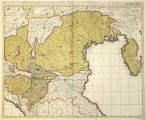
Kein Einband. Condition: Gut. Kupferkarte, verlegt vei G und L Valk, ca. 1700, altkoloriert, Blattma�: 50x60 cm., min. Randl�suren. Die Karte wird begrenzt im S�dwesten durch den Mainlauf und Schweinfurt, im S�dosten durch B�hmen mit Prag, im Nordosten durch Brandenburg und im Nordwesten durch Hameln und Hildesheim.
-
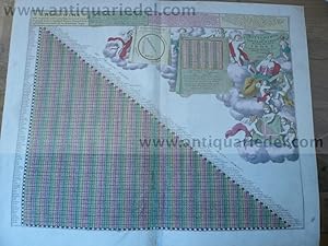
Kein Einband. Condition: Gut. Meilenzeiger. "Astygnomon sive Europaearum Urbium Maxime Insignum Index". Altkolor. Kupferstich von G.Valck, Amsterdam um 1700. Ca. 42 x 53 cm., Blatt: 50x60 cm. Mit gr. ausgem. fig. Kart. u. zahlr. geometr. mathemat. Formen und Werkzeugen. Etw. finger- u. schmutzfl., tls. knittrig, unterl. Falzeinri� unten. Diverse Reparaturen, verursacht durch S�urefra�.
-

Russia Alba, sive Moscovia, regio valde extensa divisaque in Regna, Ducatus, Pricipatus, et Provincias, cum adjacentibus Regnis, cura Gerardi et Leonardi Valk cum Privilegio ordinum Hollandiae et West-Frisiae
Published by G. & L. Valck, Amsterdam, 1702
Seller: Antiquariat Reinhold Berg eK Inh. R.Berg, Regensburg, Germany
Seller rating 5 out of 5 stars
Map
Other. Original copper engraving, hand colored in outline and wash when published. Scarce map of Russia and Ukraine, hand colored by political subdivisions, by Gerard and Leonard Valk.The map extends to the east, showing some portions of the Tartar and Mongol regions. In good condition. 480 by 590mm (19 by 23� inches).
-
Kein Einband. Condition: Befriedigend. Russia, map, anno 1710, G.Valk, old colours Coppermap, edited by G. Valk, anno 1710, old colours, size of the leaf: 51x61 cm., centerfold partly restored.
-
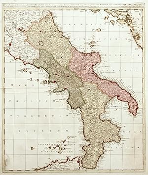
Regnum Neapolis�
Published by Amsterdam,, 1710
Seller: libreria antiquaria perini Sas di Perini, Verona, VR, Italy
Seller rating 5 out of 5 stars
Art / Print / Poster
Incisione in rame, 582x494. Gerard Valk, oltre alla collaborazione con Pieter Schenk, pubblic� insieme al figlio Leonard numerose carte fino al 1720 ca. Ottimo esemplare. Nr.cat: P4290008.
-
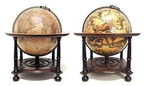
An extraordinary, eye-catching pair of 15 inch. table globes from the Golden Age.
Published by Amsterdam, Gerard and Leonard Valk 1750/1700, 1750
Seller: Antiquariaat de Roo, Zwijndrecht, Netherlands
Seller rating 4 out of 5 stars

US$ 375,329.50
US$ 26.50 shipping
Ships from Netherlands to U.S.A.Quantity: 1 available
Add to basketTerrestrial globe: Cosmotheore, Caelesti nostro Globo, Par, et plane Novus, Hic Terrestris ut existeret, Certo scias, Errore Veterum Sublato, Non tantum Utriusque Orbis, Longitudines ac Latitudines, Par reiterates Neotericorum Observationes, Hicce esse restitutas, Sed et nullum typis Emendatiorem prodiisse, Hoc igitur Novissim� tam diu fruere, Donec sub Majori forma, Me� aere Alios excudam Gerardus Valk Calcographus, Amsterdami, A(nn)o 17(50) Cum privilegio. / Celestial globe: Uranographia, Caelum omne hie Complectens, Illa pro ut aucta, et ad annum 1700 Competum, Magno ab Hevelio, correcta est, ita, ejus ex Prototypis, sua noviter haec Ectypa, veris Astronomiae cultoribus, exhibit et consecrate, Ger. et Leon. Valk, Amstelaedamenses. A pair of rare Valk table globes published by Gerard and Leonard Valk in Amsterdam in 1700 and 1750. The Dutch globe makers Gerard Valk (1652-1726) and his son Leonard Valk (1675-1746) were the only significant publishers of globes in the Netherlands in the eighteenth century. The design of their globes was completely new and incorporated the latest geographical and astronomical discoveries, and they were hence the most accurate globes for that time. Valk completed his present 15-inch. (39 cm) Globes in 1707, and the copper plates went through several states over the years. The terrestrial globe is here in what Van der Krogt calls state 3 (with the date changed to 1750 by pasting a slip over the "45" of the "1745" in state 2). Leonard Valk made the most important revision to the 1707 topographic image sometime between 1730 and 1745, when he revised the Caspian Sea and the Aral Sea based on a new mapping. The celestial globe is in state 2 (as published ca. 1711, when Leonard's name was added to his father's, but it was not further revised until 1745). The Valks apparently numbered each globe they made, stamping the number on the back of the brass meridian ring near the north pole and beginning a new series when the plate was revised. The present terrestrial globe is numbered "3"; the meridian ring of the celestial globe is not original and bears no number. They apparently made very few of these globes, for in the present states Van der Krogt records no numbers higher than 10 for the terrestrial globe or 7 for the globe. The present pair forms a beautiful example of the outstanding work of the Dutch Valk family as globe makers. Each globe was made up of two hollow paper-mach� hemispheres joined at the equator and covered with a layer of plaster, the whole covered with eighteen engraved gores and two polar calottes, the celestial calottes on the ecliptic poles. The equator is graduated in individual degrees, the ecliptic in individual days of the houses of the Zodiac with sigils. Each globe has a brass meridian ring and hour dial with a hand-coloured printed paper ring on the wooden horizon ring, showing degrees and the days of the houses of the Zodiac. Each globe is supported by four columns with bun feet on a Dutch-style oak stand connected by cross-stretchers supporting a circular base plate, with support for the meridian ring at its centre. Including the oak stand. Each globe has a height of 59 cm (23 inches). The last two digits of the year on the terrestrial globe have been nearly obliterated, but one can see that they were formerly covered with a slip, as expected in state 3. The celestial globe has a new stand, a later hour dial, a brass meridian ring, and its paper horizon ring is in facsimile. Some minor paper repairs in Ethiopia (terrestrial globe) have been professionally restored. Overall, in good condition. An extraordinary, eye-catching set of these rare globes. Literature: Van der Krogt, Globi Neerlandici, pp. 313-331, 555-557, globes VAL III T state 3 (4 copies: numbered 2, 4, 8 & 10) & VAL III C state 2 (4 copies, numbered 2, 6, 7 & one unnumbered).
-
Regnum Hiberniae, divisum in Provinciae Ultoniam, Connachiam, Lageniam et Momoniam
Published by c.1720, Amsterdam, 1720
Seller: Alexandre Antique Prints, Maps & Books, Toronto, ON, Canada
Seller rating 4 out of 5 stars
Map
Detailed map of Ireland., Size : 593x503 (mm), 23.35x19.80 (Inches), Original Hand Coloring Very Good, backed on acid free tissue paper for long term preservation.
-

Sueciae Magnae, Totius Orbis Regni Antiquissimi, Hodierna In Sex Principales Suas Partes, Gothiam Nempe, Sueciam Propriam, Sive Stricte Sumptam, Nordlandiam, Finniam, Ingriam, Livoniam.
Published by Gerard & Leonard Valk, Amsterdam, 1710
Seller: Antiquariat Reinhold Berg eK Inh. R.Berg, Regensburg, Germany
Seller rating 5 out of 5 stars
Map
Other. Copper engraving, hand colored in outline and wash when published. This fine map shows Norway, Sweden, Finland, Estonia and Latvia. 595 by 495mm (23� by 19� inches).
-

Europa Pars tenet Haec Mundi reliquas Celeberrima Partes Auctoribus.
Published by Amsterdam 1706 (data anticamente ms. sul cartiglio), 1706
Seller: Libreria Ex Libris ALAI-ILAB/LILA member, Roma, RM, Italy
Seller rating 5 out of 5 stars
Map
Carta geografica originale (cm. 59x49 pi� margini bianchi). Coloritura antica all'acquerello. Due piccole tracce di ossidazione e due macchioline su un margine laterale bianco. Buon esemplare.
-
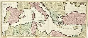
Mare Mediterraneum exhibens oras Hispaniae, Galliae, Italiae�
Published by Amsterdam, 1700
Seller: libreria antiquaria perini Sas di Perini, Verona, VR, Italy
Seller rating 5 out of 5 stars
Art / Print / Poster
Incisione in rame, colorata d'epoca, mm 495x1165. Decorativa carta in bella coloritura. Ottimo esemplare, seppur con una piccola mancanza reintegrata in basso destra, margine sinistro breve qualche piccola menda e qualche leggero rinforzo alle pieghe. Gerard e Leonard Valck o Valk, padre e figlio, furono tra i pi? noti stampatori della fine del periodo d'oro della cartografia fiamminga, autori di numerose carte, lavorando spesso in societ? con Schenk.Copperplate, original colouring, mm 495x1165. Gerard and Leonard Valck or Valk, father and son, were amongst the most important cartographers in the late XVIIth century; they published many maps, often in association with Schenck. A good example with a small restoration bottom right, left margin trimmed at platemark, some stains at bottom margin and little reinforcements at folds and margins. Nr.cat: Cod 7929.
-
Respublica Veneta, Ducatus Mutinae, Parmae et Mirandulae divisa in Ducatum Venetum , et ei subjectas ditiones Forum Julii, Vicentii, Patavii, Tervisium, Rhodiginae, Veronae, Bresciae, Cremae et Bergami cum adjacentibus regionibus
Published by Amsterdam, 1720
Seller: libreria antiquaria perini Sas di Perini, Verona, VR, Italy
Seller rating 5 out of 5 stars
Art / Print / Poster
Incisione in rame, mm 495x600, colore d'epoca. Splendido esemplare di questa non comune carta del Dominio Veneto. Gerard Valk � capostipite della pi? importante famiglia di stampatori di Amsterdam di fine Seicento, che associ� il figlio Leonardus e Peter Schenk, di cui Leonardus spos� la figlia. L'attivit? continu� grazie a figli e nipoti fino alla seconda met? del '700. Nr.cat: Cod. 1908.
-
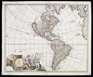
America Aurea Pars Alter Mundi Auctoribus
Published by Amsterdam, 1700
Seller: Donald A. Heald Rare Books (ABAA), New York, NY, U.S.A.
Seller rating 5 out of 5 stars
Map
Copper-engraved map, full period hand-colouring. Highly decorative map of North and South America showing California as an island and here with full period hand colouring. This decorative map by the Valk brothers is after a similar map by Carol Allard, first published circa 1696. Cartographically, both Allard and the Valks borrow heavily from the De Wit map of 1675, naming the Great Lakes, showing California as an island and with a Terra Esonis and Fretum Anian in the northwest. Interestingly, the Valks here re-issue the first state of Allard's map, i.e. before the re-engraving of the western Great Lakes and the Mississippi River (based on Hennepin's mapping). In addition, the lower left corner of the cartouche is left blank, whereas in subsequent issues of the Allard map, an inset of New Zealand appears. In the present issue, there are no toponyms on Terra Esonis and the South Pacific is without New Guinea. Cf. Burden, The Mapping of North America II: 724 (discussing the map under the entry for Allard); Wagner, Cartography of the Northwest Coast, 496; Tooley, "California as an Island," 68 in Tooley, The Mapping of America; McLaughlin,The Mapping of California as an Island, 176.
-
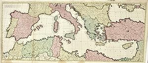
Mare Mediterraneum exhibens oras Hispaniae, Galliae, Italiae�
Published by Amsterdam, 1700
Seller: libreria antiquaria perini Sas di Perini, Verona, VR, Italy
Seller rating 5 out of 5 stars
Art / Print / Poster
Incisione in rame, colorata d�epoca, 495x1165. Gerard e Leonard Valck o Valk, padre e figlio, furono tra i pi? noti stampatori della fine del periodo d�oro della cartografia fiamminga, autori di numerose carte, lavorando spesso in societ? con Schenk. Decorativa carta in bella coloritura. Ottimo esemplare, seppur con una piccola mancanza reintegrata in basso destra, rifilata alla lastra a sin. e lievi aloni in basso. Nr.cat: 966.