
Order Total (1 Item Items):
Shipping Destination:

Leth Hendrick (32 results)
Skip to main search results
Search filters
Product Type
- All Product Types
- Books (1)
- Magazines & Periodicals (No further results match this refinement)
- Comics (No further results match this refinement)
- Sheet Music (No further results match this refinement)
- Art, Prints & Posters (1)
- Photographs (No further results match this refinement)
- Maps (30)
- Manuscripts & Paper Collectibles (No further results match this refinement)
Condition Learn more
- New (No further results match this refinement)
- As New, Fine or Near Fine (No further results match this refinement)
- Very Good or Good (2)
- Fair or Poor (No further results match this refinement)
- As Described (30)
Binding
- All Bindings
- Hardcover (No further results match this refinement)
- Softcover (1)
Collectible Attributes
- First Edition (No further results match this refinement)
- Signed (No further results match this refinement)
- Dust Jacket (No further results match this refinement)
- Seller-Supplied Images (7)
- Not Print on Demand (32)
Language (1)
Free Shipping
Seller Location
Seller Rating
-

Carte Nouvelle de la Mer du Sud, dressee par Ordre des principaux Directeurs des Memoires les plus recents et des Relations des Navigateurs les plus Modernes .
Published by Amsterdam, 1730
Seller: Clive A. Burden Ltd., Chalfont St. Giles, BUCKS, United Kingdom
Seller rating 5 out of 5 stars

Map
US$ 20,095.66
US$ 29.55 shipping
Ships from United Kingdom to U.S.A.Quantity: 1 available
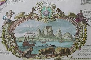
Add to basketNo binding. Condition: Good. 590 x 940 mm., in fine early wash colour, some light restoration to folds at the centre, otherwise in good condition. An attractive example of the third state of Hendrick de Leth's rare large map of the American continent which extends to cover both the Pacific and Atlantic Oceans along with their Asian, European, and African coastlines. The first state is considered a proof. It is an amalgam of two earlier maps, the very rare wall map by Nicholas de Fer of 1713, and Henri Abraham Chatelain's of 1719. Although it covers such a large area, the focus of the map as stated in the title is the 'Mer du Sud', or Pacific Ocean.Hendrick de Leth (1703-66) was born in Amsterdam, the son of the engraver and bookseller Andries de Leth (1662-1731). His father had acquired the business of Nicolaas Visscher II. Hendrick joined his father and subsequently the bookseller's guild in 1728. This map is undated and was separately published. It is usually ascribed the date of c.1730.The map displays the tracks of famous navigators such as Ferdinand Magellan and Willem Schouten, along with the tracks of the Spanish Manila galleons across the Pacific Ocean. Indeed, the whole map is focused on global trade, an activity the Dutch were heavily involved in. Trade routes are shown across the Oceans. As with the earlier maps from which it is derived, it has a French bias with the English colonies in North America for example, confined to the east coast. As might be expected of this timeframe the Mississippi River is mistakenly depicted flowing into the Gulf of Mexico too far to the west. The Great Lakes are well displayed unlike California which is here still depicted as an island. By this date the myth which had started in 1622 had been refuted by Father Eusebio Kino in a publication of 1705. Throughout this whole period maps were published with California as a peninsula as not everyone had been convinced. Depictions of it as an island continued until the middle of the eighteenth century.New Holland or present-day Australia is curiously depicted with a confused coastline incorporating 'Terre de Quir' and New Zealand. It reflects the yet to be charted eastern coastline of Australia and the accurate mapping of New Zealand undertaken by James Cook later in the century.The map contains several insets. Over the north Pacific an ornate cartouche includes three plans of the ports of Vera Cruz, Rio de Janeiro, and Havana. This replaces one of Niagara Falls as seen in the original Nicolas de Fer map. In the upper right corner of the map is a map of the Straits of Gibraltar oriented at ninety degrees. From left to right across the bottom are several more cartouche which conveniently enable de Leth to evade the issue of the presence of a southern continent or not. Lower left are plans of Porto Bello and the Isthmus of Panama. The south Atlantic is covered by an extremely attractive vignette view of the Cape of Good Hope and Table Mountain, at the time a significant colony for the Dutch in their trade with the East Indies. The dating of this third state likely coincides with the commencement of the French and Indian War in 1754. Provenance: Richard B. Arkway Inc. 2002; Juan and Peggy Rada Collection. Koeman (1967-70 p. 267; Leighly (1972) 169; McLaughlin & Mayo. (1995) 220; Norwich (1983) 320; Tooley (1964) no. 94.
-

Nouvelle carte du Comt� de Flandre
Published by Amsterdam 1770 ca., 1770
Seller: Libreria Ex Libris ALAI-ILAB/LILA member, Roma, RM, Italy
Seller rating 5 out of 5 stars
Map
Incisione originale su rame (cm. 21,5x17 pi� ampi margini). Coloritura coeva all'acquarello dei confini. Ottimo esemplare. Non comune.
-
Seigneurie d'Overysel
Published by Amsterdam 1770 ca., 1770
Seller: Libreria Ex Libris ALAI-ILAB/LILA member, Roma, RM, Italy
Seller rating 5 out of 5 stars
Map
Incisione originale su rame (cm. 21,5x16,5 pi� ampi margini). Coloritura coeva all'acquarello dei confini. Ottimo esemplare. Non comune.
-
Friesland
Published by Amsterdam 1770 ca., 1770
Seller: Libreria Ex Libris ALAI-ILAB/LILA member, Roma, RM, Italy
Seller rating 5 out of 5 stars
Map
Incisione originale su rame (cm. 21x16 pi� ampi margini). Coloritura coeva all'acquarello dei confini. Ottimo esemplare. Non comune.
-
La France
Published by Amsterdam 1770 ca., 1770
Seller: Libreria Ex Libris ALAI-ILAB/LILA member, Roma, RM, Italy
Seller rating 5 out of 5 stars
Map
Incisione originale su rame (cm. 22x16,5 pi� ampi margini). Coloritura coeva all'acquarello dei confini. Ottimo esemplare. Non comune.
-
La Sud Hollande
Published by Amsterdam 1770 ca., 1770
Seller: Libreria Ex Libris ALAI-ILAB/LILA member, Roma, RM, Italy
Seller rating 5 out of 5 stars
Map
Incisione originale su rame (cm. 23x17 pi� ampi margini). Coloritura coeva all'acquarello dei confini. Ottimo esemplare. Non comune.
-
Comitatus Zelandiae
Published by Amsterdam 1770 ca., 1770
Seller: Libreria Ex Libris ALAI-ILAB/LILA member, Roma, RM, Italy
Seller rating 5 out of 5 stars
Map
Incisione originale su rame (cm. 22x16 pi� ampi margini). Coloritura coeva all'acquarello dei confini. Ottimo esemplare. Non comune.
-
Nouvelle carte du Duch� de Brabant
Published by Amsterdam 1770 ca., 1770
Seller: Libreria Ex Libris ALAI-ILAB/LILA member, Roma, RM, Italy
Seller rating 5 out of 5 stars
Map
Incisione originale su rame (cm. 18x19,5 pi� ampi margini). Coloritura coeva all'acquarello dei confini. Ottimo esemplare. Non comune.
-
Duch� de Gueldre
Published by Amsterdam 1770 ca., 1770
Seller: Libreria Ex Libris ALAI-ILAB/LILA member, Roma, RM, Italy
Seller rating 5 out of 5 stars
Map
Incisione originale su rame (cm. 18x23 pi� margini). Coloritura coeva all'acquarello dei confini. Ottimo esemplare. Non comune.
-
Les Royaumes de Portugal et d'Algarve
Published by Amsterdam 1770 ca., 1770
Seller: Libreria Ex Libris ALAI-ILAB/LILA member, Roma, RM, Italy
Seller rating 5 out of 5 stars
Map
Incisione originale su rame (cm. 17x22,5 pi� ampi margini). Coloritura coeva all'acquarello dei confini. Ottimo esemplare. Non comune.
-
Isle et Royaume de Candie
Published by Amsterdam 1770 ca., 1770
Seller: Libreria Ex Libris ALAI-ILAB/LILA member, Roma, RM, Italy
Seller rating 5 out of 5 stars
Map
Incisione originale su rame (cm. 22x17 pi� ampi margini). Coloritura coeva all'acquarello dei confini. Una piega nella parte sinistra dell'incisione altrimenti ottimo esemplare. Non comune.
-
La Nord Hollande
Published by Amsterdam 1770 ca., 1770
Seller: Libreria Ex Libris ALAI-ILAB/LILA member, Roma, RM, Italy
Seller rating 5 out of 5 stars
Map
Incisione originale su rame (cm. 22,5x16,5 pi� ampi margini). Coloritura coeva all'acquarello dei confini. Ottimo esemplare. Non comune.
-
L'Empire d'Allemagne
Published by Amsterdam 1770 ca., 1770
Seller: Libreria Ex Libris ALAI-ILAB/LILA member, Roma, RM, Italy
Seller rating 5 out of 5 stars
Map
Incisione originale su rame (cm. 22x16 pi� ampi margini). Coloritura coeva all'acquarello dei confini. Pallido alone al margine superiore bianco, ma ottimo esemplare. Non comune.
-
Uitrecht
Published by Amsterdam 1770 ca., 1770
Seller: Libreria Ex Libris ALAI-ILAB/LILA member, Roma, RM, Italy
Seller rating 5 out of 5 stars
Map
Incisione originale su rame (cm. 22x17 pi� ampi margini). Coloritura coeva all'acquarello dei confini. Ottimo esemplare. Non comune.
-
Groningen en Ommelanden
Published by Amsterdam 1770 ca., 1770
Seller: Libreria Ex Libris ALAI-ILAB/LILA member, Roma, RM, Italy
Seller rating 5 out of 5 stars
Map
Incisione originale su rame (cm. 16,5x21 pi� ampi margini). Coloritura coeva all'acquarello dei confini. Ottimo esemplare. Non comune.
-
Les Isles et coste de la Dalmatie
Published by Amsterdam 1770 ca., 1770
Seller: Libreria Ex Libris ALAI-ILAB/LILA member, Roma, RM, Italy
Seller rating 5 out of 5 stars
Map
Incisione originale su rame (cm. 22x17 pi� ampi margini). Coloritura coeva all'acquarello dei confini. Ottimo esemplare. Non comune.
-
La Grece ou partie Meridionale de la Turquie d'Europe
Published by Amsterdam 1770 ca., 1770
Seller: Libreria Ex Libris ALAI-ILAB/LILA member, Roma, RM, Italy
Seller rating 5 out of 5 stars
Map
Incisione originale su rame (cm. 22x17 pi� ampi margini). Coloritura coeva all'acquarello dei confini. Ottimo esemplare. Non comune.
-
Estats de la couronne de Suede
Published by Amsterdam 1770 ca., 1770
Seller: Libreria Ex Libris ALAI-ILAB/LILA member, Roma, RM, Italy
Seller rating 5 out of 5 stars
Map
Incisione originale su rame (cm. 22x16,5 pi� ampi margini). Coloritura coeva all'acquarello dei confini. Pallido alone al margine superiore bianco, ma ottimo esemplare. Non comune.
-
Nouvelle Carte des XVII Provinces du Pais Bas
Published by Amsterdam 1770 ca., 1770
Seller: Libreria Ex Libris ALAI-ILAB/LILA member, Roma, RM, Italy
Seller rating 5 out of 5 stars
Map
Incisione originale su rame (cm. 15x19 pi� ampi margini). Coloritura coeva all'acquarello dei confini. Pallido alone al margine superiore bianco, ma ottimo esemplare. Non comune.
-
La Suisse
Published by Amsterdam 1770 ca., 1770
Seller: Libreria Ex Libris ALAI-ILAB/LILA member, Roma, RM, Italy
Seller rating 5 out of 5 stars
Map
Incisione originale su rame (cm. 22x16 pi� ampi margini). Coloritura coeva all'acquarello dei confini. Pallido alone al margine superiore bianco, ma ottimo esemplare. Non comune.
-
Le Royaume de Hongrie
Published by Amsterdam 1770 ca., 1770
Seller: Libreria Ex Libris ALAI-ILAB/LILA member, Roma, RM, Italy
Seller rating 5 out of 5 stars
Map
Incisione originale su rame (cm. 22x16,5 pi� ampi margini). Coloritura coeva all'acquarello dei confini. Ottimo esemplare. Non comune.
-
Nouvelle carte de l'Europe
Published by Amsterdam 1770 ca., 1770
Seller: Libreria Ex Libris ALAI-ILAB/LILA member, Roma, RM, Italy
Seller rating 5 out of 5 stars
Map
Incisione originale su rame (cm. 20,5x15,5 pi� ampi margini). Coloritura coeva all'acquarello dei confini. Pallido alone al margine superiore bianco, ma ottimo esemplare. Non comune.
-
L'Afrique
Published by Amsterdam 1770 ca., 1770
Seller: Libreria Ex Libris ALAI-ILAB/LILA member, Roma, RM, Italy
Seller rating 5 out of 5 stars
Map
Incisione originale su rame (cm. 22,5x16,5 pi� ampi margini). Coloritura coeva all'acquarello dei confini. Pallido alone al margine superiore bianco, ma ottimo esemplare. Non comune.
-
Carte de l'Amerique meridionale
Published by Amsterdam 1770 ca., 1770
Seller: Libreria Ex Libris ALAI-ILAB/LILA member, Roma, RM, Italy
Seller rating 5 out of 5 stars
Map
Incisione originale su rame (cm. 22x16,5 pi� ampi margini). Coloritura coeva all'acquarello dei confini. Pallido alone al margine superiore bianco, ma ottimo esemplare. Non comune.
-
Estats du Grand Duc de Moscovie ou de l'Empereur de la Russie blanch�
Published by Amsterdam 1770 ca., 1770
Seller: Libreria Ex Libris ALAI-ILAB/LILA member, Roma, RM, Italy
Seller rating 5 out of 5 stars
Map
Incisione originale su rame (cm. 21,5x16,5 pi� ampi margini). Coloritura coeva all'acquarello dei confini. Pallido alone al margine superiore bianco, ma ottimo esemplare. Non comune.
-
L'Asie
Published by Amsterdam 1770 ca., 1770
Seller: Libreria Ex Libris ALAI-ILAB/LILA member, Roma, RM, Italy
Seller rating 5 out of 5 stars
Map
Incisione originale su rame (cm. 22,5x17 pi� ampi margini). Coloritura coeva all'acquarello dei confini. Pallido alone al margine superiore bianco, ma ottimo esemplare. Non comune.
-

Le Nouveau Continent ou L'Amerique
Published by Amsterdam, 1740
Seller: Clive A. Burden Ltd., Chalfont St. Giles, BUCKS, United Kingdom
Seller rating 5 out of 5 stars
Map
US$ 1,288.19
US$ 29.55 shipping
Ships from United Kingdom to U.S.A.Quantity: 1 available
Add to basketNo binding. Condition: Very Good. 480 x 510 mm., in early wash colour, in good condition. An uncommon map of the American continent by Hendrik de Leth published c.1740. Depicted on an equal area Mercator projection with corrected lines of longitude, it illustrates the continent at a time just before conflict was about to reshape North America. France is granted all of Louisiana and Florida and California is correctly illustrated as a peninsula. It draws on Nicolas Sanson for information regarding climate, native peoples, and languages. The cartography is drawn from the more recent work of Robert de Vaugondy. The unknown northwest is marked as 'Mer Glaciale'. In South America, the source of the Rio de la Plata is given as the mythical lake 'Xarayes'. Similarly, the higher latitudes are sparsely detailed, especially 'Terre Magellanique' or modern-day Patagonia. The whole is finished with an attractive cartouche for the title and scale of miles. Hendrick de Leth (1703-66) was born in Amsterdam, the son of the engraver and bookseller Andries de Leth (1662-31). His father had acquired the business of Nicolaas Visscher II from his widow Elizabeth Visscher (fl.1702-26). Hendrick joined his father and subsequently the bookseller's guild in 1728. He is also well known for collaborating with Leonard Schenk and for his production of topographical works. Provenance: Richard B. Arkway 2001; Juan and Peggy Rada Collection. Koeman (1967-70) p. 267; Tooley's Dictionary (1999-2004).
-

Carte de la petite Tartarie dress�e par ordre de l'Imperatrice de toutes le Russies
Published by Amsterdam 1785 ca., 1785
Seller: Libreria Ex Libris ALAI-ILAB/LILA member, Roma, RM, Italy
Seller rating 5 out of 5 stars
Map
Carta geografica originale (cm. 48,5x41,5 pi� ampi margini bianchi). Coloritura all'acquarello. Alcuni aloni marginali di umidit� (ben lontani dalla parte incisa), peraltro esemplare in ottimo stato di conservazione. Rara carta ('grav� d'apres la copie de Petersbourg dress�e par les Ingenieurs de sa Maj. l'Imperatrice de Russie') della parte meridionale dell'Ucraina. Basata su una mappa russa disegnata per ordine con tutta probabilit� di Caterina la Grande che nel 1783 annesse la Crimea.
-
Carte Nouvelle de la Mer du Sud dresse par ordere des principaux Directeurs, & tiree des Memoires les plus receiits et des Relations des Navigateurs les plus Modernes, tant de France que d'Espagno.
Published by Amsterdam: for Hendrick and Andries de Leth by Visscher, [1740]., 1740
Seller: Arader Galleries - AraderNYC, New York, NY, U.S.A.
Seller rating 5 out of 5 stars
Two sheets joined, float mounted and framed (23 1/8 x 36 1/8 inches to the neat line, margins showing the plate-mark). Fine engraved map of the Southern Hemisphere, with six fine insets of plans of important port cities including Veracruz, Rio de Janeiro, and Havana, an exceptionally fine vignettes of Mexico City, and the Cape of Good Hope. A MAGNIFICENT LARGE SCALE 18TH CENTURY DUTCH MAP OF THE WORLD. Issued separately and EXCEPTIONALLY RARE. Based in part on de Fer's also extremely rare 1713 wall map, this is the third issue, with the inset city plans replacing a vignette of Niagara Falls and the publisher's imprint below the title. Hendrick de Leth began his cartographic career working for the foremost family printing company in 17th and 18th-century Amsterdam, the Visscher firm. The family of Visscher was one of the most distinguished of all 17th-century cartographic firms, and a major player in the era now considered the golden age of Dutch mapmaking. In the late 1600's, a period of great geographical discovery, Amsterdam became an international center of the arts and of cartography, with engravers and printers produced magnificent maps and charts of every kind. The fields of artistic production and mapmaking were arguably more seamlessly united during this era than any period before or since, as the strong competition among publishers meant that maps not only had to be scrupulously accurate, but also visually appealing. In this milieu, a number of venerable firms, including those established by Blaeu, Jansson, Hondius, as well as Visscher, competed for the ever-expanding market for maps and atlases. The firm founded by Nicholas Visscher set standards for exceptional quality that few others were able to equal, and Hendrick de Leth, who eventually rose to assume control of the Visscher publishing house in the 18th century, maintained the company's standards for excellence during a period when Amsterdam's cartographic preeminence was just beginning to be challenged by the French school of scientific cartography. Boasting advanced geographical information, fine engraving and coloring, and striking decoration, this map is one of de Leth's foremost works, and a fundamental example the best in 18th-century Dutch cartography. Encompassing much of the world, including all of the Atlantic and Pacific Oceans, it includes a wealth of geographical, historical, practical and anecdotal information, including commercial sea routes and the paths of famous explorers like Magellan, as well as inset plans of important port cities including Veracruz, Rio de Janeiro, and Havana. One cartouche at lower center is surmounted by a plan of Mexico City, while another, at lower right, shows an atmospheric view of the dramatic coast of the Cape of Good Hope. Decorative flourishes include cherubs bearing inscribed informational banners, magnificent strapwork designs, wild animals and allegorical figures. This is a magnificent and highly engaging map by one of the last prominent mapmakers from the golden age of Dutch cartography. McLaughlin 220; Norwich 320; Tooley (Amer) p. 133, 94; Tooley (MCC-23) 75. Catalogued by Kate Hunter.
-

Amsterdam - Hendrik de Leth, 1783
Seller: Inter-Antiquariaat Mefferdt & De Jonge, Amsterdam, Netherlands
Seller rating 3 out of 5 stars

Map
US$ 2,789.35
US$ 48.40 shipping
Ships from Netherlands to U.S.A.Quantity: 1 available
Add to basketPLAN TRES EXACT DE LA VILLE FAMEUSE MARCHANDE D'AMSTERDAM [very exact plan of the famous merchant city of Amsterdam]. Copper engraving printed on two sheets, made by Hendrik de Leth, published in 1783. Coloured by a later hand. Size: 57.5 � 88 cm. On 24 and 27 April 1734, the following advertisement appeared in the Amsterdamsche Courant: "In Amsterdam, at the Beurssluys, Hendrik de Leth now publishes an entirely new and accurate plan of the city of Amsterdam, with many additions not found on any previous maps; adorned on either side with the coats of arms of the Honourable and Most Noble Gentlemen Burgomasters of this city, from the Reformation to the present day, carefully reviewed by notable connoisseurs." Buyers could choose between a luxurious versionflanked by coats of arms of the city's mayorsand a more modest version without these heraldic panels. This example concerns the latter, without coats of arms. Among many competitors (such as Covens & Mortier), Hendrik de Leth managed to produce a reliable map that was particularly useful within the city's administrative apparatus. Despite its elegant French title, likely intended for ceremonial or representative purposes, the rest of the print is entirely in Dutch, making it more accessible to professional and municipal users. Below the title appears the phrase: "Grav�e et mis au jour Par Henry de Leth a l'enseigne du Pecheur" which translates as: "Engraved and brought to light by Hendrik de Leth under the sign of the Fisherman." This refers to the former publishing house of Nicolaes Visscher II, which retained that name even after his death in 1702. Both Hendrik de Leth and his father Andries had worked in Visscher's shop during his lifetime. After Visscher's passing, his widow Elisabeth Verseyl continued the business until 1726. Around 1720, however, Andries de Leth had already taken over its daily operations. When he died in 1731, his son Hendrik assumed control and continued using the well-established name. The map itself is exceptionally clear and legible, with only the principal buildings shown in elevation. De Leth based his city plan on an older model, but completely redesigned the decorative elements. One subtle innovation is the way he added cast shadows to the engraved buildings in elevation a feature not seen on earlier plans. The light falls from the left, consistent with the morning sun in the east. To the left of the decorative, open curtain, we see a "Caarte van Amstelland" (Map of Amstelland). In the legend block in the upper right corner, nine buildings are marked with the letter "I." A note explains: "NB: where an 'I' appears, it indicates Jansenists." Jansenism named after Cornelius Jansenius (15851638) was a religious and political movement of the 17th and 18th centuries, especially influential in France. It arose in reaction to developments within the Catholic Church and the absolutism of contemporary monarchs. Jansenists were known for their ascetic rejection of worldly life and their pessimistic ethics. Among other things, they also rejected papal infallibility. The fact that buildings associated with Jansenism are singled out on this map suggests that Hendrik de Leth, both engraver and publisher, may have been sympathetic to this political-religious current. The central cartouche beneath the map is tastefully and carefully designed. The title is integrated into a group of allegorical figures: the maiden of the city is flanked by the two lions of the Amsterdam coat of arms and by the river gods of the Amstel and the IJ, while Fortuna rises from the sea. The compass rose and scale bar are given a three-dimensional sculptural quality and are visually embedded within the scene. The city's seal and arms, shown at the top of the map, are held aloft by two putti. Literature: Marc Hameleers - Kaarten van Amsterdam 1538-1865, no. 114 p.228-231 Prijs: Euro 2.350,-.
