
Order Total (1 Item Items):
Shipping Destination:

Lotter Seutter (40 results)
Skip to main search results
Search filters
Product Type
- All Product Types
- Books (18)
- Magazines & Periodicals (No further results match this refinement)
- Comics (No further results match this refinement)
- Sheet Music (No further results match this refinement)
- Art, Prints & Posters (13)
- Photographs (No further results match this refinement)
- Maps (9)
- Manuscripts & Paper Collectibles (No further results match this refinement)
Condition Learn more
- New (No further results match this refinement)
- As New, Fine or Near Fine (No further results match this refinement)
- Very Good or Good (6)
- Fair or Poor (No further results match this refinement)
- As Described (34)
Binding
- All Bindings
- Hardcover (3)
- Softcover (No further results match this refinement)
Collectible Attributes
- First Edition (1)
- Signed (No further results match this refinement)
- Dust Jacket (No further results match this refinement)
- Seller-Supplied Images (34)
- Not Print on Demand (40)
Language (2)
Free Shipping
Seller Location
Seller Rating
-
WEISSENFELS. - Karte. Praefecturae Leicopetranae" Altkolorierter Kupferstich, um 1740
Published by . um 1740, ., 1740
Seller: Buecherstube Eilert, Versandantiquariat, Dresden, DD, Germany
Seller rating 5 out of 5 stars

48 x 56,5 cm. Kupferstich, gro�e, seitliche fig�rliche Kartusche, rechts und links Ortssuchregister. Grenzkoloriert, Fl�che zart farbig koloriert. Auf Leinwand aufgezogen. Flexibel, 8 Segmente 15 x 25 cm, faltbar. R�ckseiten ( wohl sp�ter ) beschriftet. Insgesamt guter Zustand. 26, DD, Krippe Sprache: de, lat.
-
[Composite Atlas]
Published by Homann Heirs / Matthaus Seutter / Tobias Conrad Lotter, 1750
Seller: Barry Lawrence Ruderman, La Jolla, CA, U.S.A.
Seller rating 5 out of 5 stars
Hardcover. Condition: vg. Interesting composite historical atlas featuring an engraved portrait-frontispiece of Pope Clement XIV and 26 maps, plans, and plates mostly in contemporary coloring on 32 sheets (31 of which are double-page), as we. Folio. Contemporary calf, ruled in blind; spin in seven compartments separated by raised bands. 50 engraved sheets of maps and tables (numbered 1-36 and 37-51 in early red chalk; presumably lacking one at number 36) many of which in original hand-color. Interesting composite historical atlas featuring an engraved portrait-frontispiece of Pope Clement XIV and 26 maps, plans, and plates mostly in contemporary coloring on 32 sheets (31 of which are double-page), as well as 12 tables (2 colored) partly engraved on 16 sheets, some of which are folded.The atlas contains notable works such as Lotter's celestial hemispheres, a world map after Delisle, an elaborate engraved compass rose by Lotter, and plans of Jerusalem (Seutter) and Venice (Lotter). Among the Homann publications, there is a detailed four-sheet plan of Rome after L. Bufalino by J. B. Nolli (here complete with four sheets, though only two are illustrated in our images), as well as maps of Germany, Poland, and W rttemberg. Other highlights include genealogical plates, historical and geographical tables, and several maps by the Parisian publishers Mondhare, Veuve Tilliard, and Debure Freres. The time map "Chronologie figuree pour l'intelligence de l'histoire des revolutions monarchiques" is also noteworthy.An unusually diverse mid-18th-century German composite atlas. Book.
-

"S.R.I. Principat. et Archiepiscopatus Salisburgensis mappa Geographica delineatus cura et studio Matth. Seutteri, S.C.M.G. Aug. Vind. A.C. Seutter delin. - Tob. Conrad Lotter sculpsit". Aus: Atlas Minor Praecipua Orbis Terrarum Imperia.
Published by Augsburg, Seutter, um 1744., 1744
Seller: Antiquariat MEINDL & SULZMANN OG, Wien - Vienna, Austria
Seller rating 5 out of 5 stars
Blattgr��e ca. 22 x 28,5 cm, Bildausschnitt ca. 19 x 25 cm (Oberrand au�erhalb des Kartenbildes braunfleckig und Einrisse hinterlegt).
-

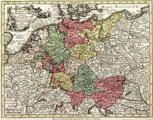
BRANDENBURG ( Kurf�rstentum ) Kupferstich "Electoratus sive Marchia Brandenburgensis .".Lotter bei Seutter Altkolorierter Kupferstich um 1745
Published by . um 1745, ., 1745
Seller: Buecherstube Eilert, Versandantiquariat, Dresden, DD, Germany
Seller rating 5 out of 5 stars
19,2 x 23,5 cm kolorierter Kupferstich, Unten links die Titelkartusche ( Wappen, fig. Staff. und Adler). Zeigt auch die Alt- und Neumark.Sehr kr�ftiges Kolorit. Karte insgesamt in gutem Zustand 19 Sprache: lat, de.
-

TRIER ( Erzbistum ) Kupferstich Karte, Landkarte "Trevirensis Archi-episcopatus et Electoratus . Eyfaliae".Lotter bei Seutter Altkolorierter Kupferstich um 1745
Published by . um 1745, ., 1745
Seller: Buecherstube Eilert, Versandantiquariat, Dresden, DD, Germany
Seller rating 5 out of 5 stars
19,6 x 25,5 altkolorierter Kupferstich, Karte zeigt das Gebiet zwischen Br�hl (Norden), Limburg, St. Wendel (S�den) und teile von Luxemburg. Mit fig�rlicher Titelkartusche und Wappen rechts unten. Verkleinerte Copie der gro�en Seutterkarte, die erstmals 1740 erschien, gestochen von seinem Schwiegersohn. Im oberen Rand und Leiste hinterklebter " Mottenfrass " ( im Preis ber�cksichtigt) sonst guter Zustand 19 Sprache: lat, de.
-
Imperium Romano-Germanicum�
Published by Augsburg,, 1750
Seller: libreria antiquaria perini Sas di Perini, Verona, VR, Italy
Seller rating 5 out of 5 stars
Art / Print / Poster
Incisione in rame, colorata d'epoca, mm 197x260, tratta da "Atlas minor". Lotter, incisore e geografo tedesco, dopo aver lavorato per Seutter, suo suocero, ne rilev� l'attivit? alla sua morte mantenendo alto il livello artistico della sua produzione. Ottimo esemplare fascinoso, con cartiglio decorativo nell'angolo sin. superiore. Nr.cat: P5280011.
-
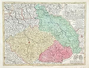
Regnum Bohemiae�
Published by Augsburg,, 1750
Seller: libreria antiquaria perini Sas di Perini, Verona, VR, Italy
Seller rating 5 out of 5 stars
Art / Print / Poster
Incisione in rame, colorata d'epoca, mm 195x255, tratta da "Atlas minor". Lotter, incisore e geografo tedesco, dopo aver lavorato per Seutter, suo suocero, ne rilev� l'attivit? alla sua morte mantenendo alto il livello artistico della sua produzione. Ottimo esemplare fascinoso, con cartiglio decorativo nell'angolo destro superiore, raffigurante cavalieri. Nr.cat: P5280012.
-
Regni Hungariae.
Published by Augsburg,, 1750
Seller: libreria antiquaria perini Sas di Perini, Verona, VR, Italy
Seller rating 5 out of 5 stars
Art / Print / Poster
Incisione in rame, colorata d'epoca, mm 200x265, tratta da "Atlas minor". Lotter, incisore e geografo tedesco, dopo aver lavorato per Seutter, suo suocero, ne rilev� l'attivit? alla sua morte mantenendo alto il livello artistico della sua produzione. Ottimo esemplare fascinoso, con cartiglio decorativo nell'angolo destro superiore. Nr.cat: P5280018.
-
Poloniae regnum ut et Magni ducat Lithuania�
Published by Augsburg, 1750
Seller: libreria antiquaria perini Sas di Perini, Verona, VR, Italy
Seller rating 5 out of 5 stars
Art / Print / Poster
Incisione in rame, colorata d'epoca, mm 197x255, tratta da "Atlas minor". Lotter, incisore e geografo tedesco, dopo aver lavorato per Seutter, suo suocero, ne rilev� l'attivit? alla sua morte mantenendo alto il livello artistico della sua produzione. Ottimo esemplare fascinoso, con cartiglio decorativo nell'angolo destro superiore. Nr.cat: P5280016.
-
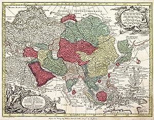
Asia cum omnibus Imperiis provinciis�
Published by Augsburg,, 1750
Seller: libreria antiquaria perini Sas di Perini, Verona, VR, Italy
Seller rating 5 out of 5 stars
Art / Print / Poster
Incisione in rame, colorata d'epoca, mm 195x255, tratta da "Atlas minor". Lotter, incisore e geografo tedesco, dopo aver lavorato per Seutter, suo suocero, ne rilev� l'attivit? alla sua morte mantenendo alto il livello artistico della sua produzione. Ottimo esemplare fascinoso, con cartigli decorativi negli angoli. Nr.cat: Cod 7448.
-

XVII Provinciae Belgii sive Germaniae inferioris�
Published by Augsburg,, 1750
Seller: libreria antiquaria perini Sas di Perini, Verona, VR, Italy
Seller rating 5 out of 5 stars
Art / Print / Poster
Incisione in rame, colorata d'epoca, mm 197x256, tratta da "Atlas minor". Raffigura Belgio e Germania inferiore. Lotter, incisore e geografo tedesco, dopo aver lavorato per Seutter, suo suocero, ne rilev� l'attivit? alla sua morte mantenendo alto il livello artistico della sua produzione. Ottimo esemplare fascinoso, con cartiglio decorativo in alto a sinistra raffigurante gli stemmi. Nr.cat: P5280010.
-
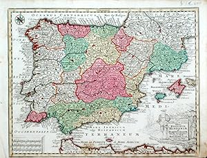
Novissima et accuratissima Regnorum Hispaniae et Portugalliae�
Published by Augsburg,, 1750
Seller: libreria antiquaria perini Sas di Perini, Verona, VR, Italy
Seller rating 5 out of 5 stars
Art / Print / Poster
Incisione in rame, colorata d'epoca, mm 197x260, tratta da "Atlas minor". Lotter, incisore e geografo tedesco, dopo aver lavorato per Seutter, suo suocero, ne rilev� l'attivit? alla sua morte mantenendo alto il livello artistico della sua produzione. Ottimo esemplare fascinoso, margine inferiore breve, cartiglio decorativo nell'angolo destro in basso. Nr.cat: P5280009.
-

Poloniae regnum et magni Ducat Lithuaniae accuratiss. Delin.
Published by Augsburg, 1750
Seller: libreria antiquaria perini Sas di Perini, Verona, VR, Italy
Seller rating 5 out of 5 stars
Art / Print / Poster
Incisione in rame, colorata d�epoca, 196x258, tratta da �Atlas minor�. Bell�esemplare Nr.cat: P5280016.
-
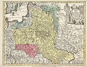
[Sachsen : Herzogtum Magdeburg u. Halle] : Ducatus Magdeburgensis et Halensis cum finitimis Delineatio geographica, curante Mattaeo Seuttero Geographo Caesar. Cum Priv. S. Reg. Polon. et Elect. Saxon [wohl: Privilegio Serenissimo Regis (K�nig) Poloniae et Electore (Kurf�rst) Saxoniae].
Published by Augsburg, s.n., s.d. (wohl: Seutter, um 1750) -, 1750
Seller: Franz K�hne Antiquariat und Kunsthandel, Affoltern am Albis, Switzerland
Seller rating 5 out of 5 stars
Gest., grenzkolorierte Faltkarte (50 x 59.5 cm, innerer Rahmen/Kartenbild 48.3 x 42 cm) in 15 Segmenten a. weisses Rohleinen aufgezogen (ev. wenig sp�ter). Linke obere Ecke mit Rokoko-Kartusche (Akanthus, Roccaillen, Wein- u. Brotsymbole), Zeichen- u. Massstabkartusche unten links, Windrose unten mittig, Ortsregister beidseits des Kartenbildes. Bis an die Einfassungslinien beschnitten, unter weitestgehendem Verlust von 'Tob. Conr. Lotter sc. Aug. Vind.' Gesamthaft sauberes, recht gutes Exemplar. - - Lorenz 1900, p. 158, Fb, N. 21890-91, mit Massangabe 0,42 x 0,49 m [B x H], dat. '(ca. 1745)', klassifiziert als 'Nachdruck' von P. Schenk jun., Geographische Charte des Herzogthums Magdeburg und Halle, 'mit lateinischen statt deutschen Landesbezeichnungen und anderer Coloratur', 1 : 305'000, 0,40 x 0,51 m, dat. '(c. 1756)', auf 1745 berichtigt p. 160. - Kolorierte Exemplare digitalis. in ULB Sachsen-Anhalt; vorliegende Version noch ohne Lotters Impressum unterhalb Bayer Naumburg (Beyernaumburg). - Die Karte wurde von Seutter bearbeitet bzw. besorgt, ('curante') resp. herausgegeben; dies geschah gem. Sandler (p. 16) im Rahmen des sog. S�chsischen Spezialatlas mit 18 Karten. Ob Seutter �berhaupt einen solchen Atlas publizierte, l�sst sich allerdings nicht verbindlich belegen (vgl. KVK). Sein Oeuvre besteht "�berwiegend aus Nachstichen und Kompilationen von Karten anderer Verlage" (NDB), wozu auch das vorliegende Blatt geh�rt (zu den 'Originalkarten', "die er nach Originalzeichnungen gestochen und unter Nennung des Autors herausgegeben hat" s. Chr. Sandler, in: Mitt. d. Ver. f. Erdkunde zu Leipzig, Jg. 1894, Leipzig 1895, p. 33). - Die Zeichnung dieser Karte des Herzogtums Magdeburg wird bis heute dem s�chs. Theologen u. Kartographen Adam Friedrich Z�rner (Mariney 1679-1742 Dresden) zugeschrieben, der ein grosses Kartenwerk von Sachsen, den sog. Atlas Augusteus (ADB, Z�rner), konzipiert hatte, welcher jedoch unvollendet und zu Lebzeiten Z�rners unver�ffentlicht geblieben ist. Nach Z�rners Tod wurde ein Grossteil der noch vorhandenen Bl�tter "an Peter Schenk in Amsterdam [verhandelt], welcher sie von 1745 bis 1760 stechen liess, Z�rner's Namen aber dabei verschwieg [.]. So entstand der Schenksche oder vielmehr Z�rnersche Atlas von Sachsen. Auch die von anderen Landkartenverlegern der damaligen Zeit, wie Homanns Erben in N�rnberg, Seutter, Lotter und Probst in Augsburg, Le Ronge in Paris, herausgegebenen Karten sind s�mmtlich Abdr�cke der Z�rnerschen Karten." (Zschoke, in: Arch. f. Post u. Telegraphie, Bd. 20, Berlin 1892, p. 174) - Die neuere Forschung zeigt, dass der Weg zu diesen Karten prim�r �ber Peter od. Pieter II. Schenk (Amsterdam 1693-1775 ibid.) f�hrt, und bez�glich der Urheberschaft derselben eher von Z�rners Atelier, Werkstatt oder 'Schule' gesprochen werden m�sste : "Neben dem ab 1719 fest in Leipzig ans�ssigen Johann Georg Schreiber darf Schenk als bedeutendster Verleger s�chsischer Spezialkarten in der ersten H�lfte des 18. Jahrhunderts gelten. Sein besonderer Erfolg beruhte auf der zeitweilig engen Kooperation mit Adam Friedrich Z�rner und dessen Schule. [.] Die Herstellung der Schenkschen Karten und Bilder fand jedoch immer in Amsterdam statt. [.] Mitte der 1740er-Jahre begann die Hochphase der Zusammenarbeit mit der Z�rner-Schule. In dichter Folge publizierte Schenk seitdem Karten der kurs�chsischen Kreise und �mter, die ganz in Z�rnerscher Darstellungsmanier gehalten waren" (P. Wiegand, 2006, in: S�chs. Biografie, online). 1752-1760 publizierte Schenk seinen 'Atlas Saxonicus Novus' mit 30 bis 49 Karten, von denen nur 4 von Z�rner, die �brigen jedoch von Trenckmann sen., einem ehem. Mitarbeiter Z�rners, und seinem Sohn entworfen worden waren. "Beide Trenckmanns waren in der Z�rnerschen Darstellungsmanier erfahren, was erkl�rt, dass die Karten des Schenkschen Atlas schon den Zeitgenossen als Z�rnersche Karten galten, ohne im engeren Sinn ein Werk dieses Kartografen zu sein." (ibid.). - Seutter hatte "1747 seinerseits.
-

Mainz ( Erzbistum ). Archiepiscopat. et Electoratus Moguntinus, ut et Comitatus utergq. Catimelibocens, Wertheimens, Erpacens. Altkolorierter Kupferstich, um 1750
Published by . um 1750, Augsburg., 1750
Seller: Buecherstube Eilert, Versandantiquariat, Dresden, DD, Germany
Seller rating 5 out of 5 stars
19,5 x 25,5 Altkol. Kupferstich. Mit zwei h�b. kleinen Kartuschen. Die kleine Seutterkarte! - Mit Druckprivileg.Die fl�chenkolorierte Karte zeigt Hessen vom Neckar bis Wetzlar im Norden. Mit zwei kleinen Kartuschen. R�nder etwas fleckig im Bild guter Zustand 25, DD, Krippe Sprache: de, lat.
-
Tabula Hungaria
Published by Augsberg, 1720
Seller: Alexandre Antique Prints, Maps & Books, Toronto, ON, Canada
Seller rating 4 out of 5 stars

Map
Size : 475x650 (mm), 18.75x25.625 (Inches), Original Hand Coloring Very Good; slight yellowing of the fold; slight ink streak due to sliding of the printing plate.
-
![Seller image for Novissimum Astronomiae Geographiae, Ac Gnomonicae Compendium Theoreticum aqque ac practieu, unacu figuris, earu explicatione et usu, in unius mappae geographicae philyram Collectum A�. 1749 - Matthaeus Seutter, S.C.M. Geogr. excud. et venale tenet Aug. Vind. in platea S. Annae [.] for sale by Antiquariat & Kunsthandlung Bachmann & Rybicki - Dresden](https://pictures.abebooks.com/inventory/md/md32226637910.jpg)
Novissimum Astronomiae Geographiae, Ac Gnomonicae Compendium Theoreticum aqque ac practieu, unacu figuris, earu explicatione et usu, in unius mappae geographicae philyram Collectum A�. 1749 - Matthaeus Seutter, S.C.M. Geogr. excud. et venale tenet Aug. Vind. in platea S. Annae [.]
Published by Augsburg, Matth�us Seutter, 1749, 1749
Seller: Antiquariat & Kunsthandlung Bachmann & Rybicki - Dresden, Dresden, Germany
Seller rating 4 out of 5 stars
Art / Print / Poster
Blatt: 65,5x52,5cm - Platte: 59x51cm - Altkolorierter Kupferstich - Lehrtafel zur Funktionsweise und Anfertigung von Sonnenuhren sowie zu deren astronomischen und geographischen Grundlagen. Neben ausf�hrlichen Erl�uterungen in Latein werden die komplexen Zusammenh�nge durch Zeichnungen einer sogenannten Quadrantenuhr (links) und einer Universal-Uhr (rechts) sowie durch weitere illustrierende Skalen und fig�rlichen Abbildungen veranschaulicht. - Gleicherma�en etwas gebr�unt, minimal angeschmutzt/fleckig. Unterer Rand knapp beschnitten. im �u�ersten Rand mit geringen Randl�suren, Ecken im wei�en Rand mit je kleinem L�chlein vom Aufh�ngen. Verso mit Tinte alt bezeichnet. Gutes, altkoloriertes Exemplar.
-
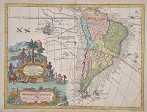
America Meridionalis, per sua Regna Province et Ins juxta observation,.
Published by Artist: Lotter/ Seutter Tobias Conrad/Albrecht ( - 1777 ) Augsburg ca : 1744, 1717
Seller: Antique Sommer& Sapunaru KG, M�nchen, Germany
Seller rating 4 out of 5 stars
Technic: Copper print, colorit: original colored, condition: Some browning, size (in cm): 19,5 x 25,5 cm, Map shows the whole of South America with detailed depiction of all national borders, rivers, lakes and mountains. With splendid title cartouche, mileage cartouche and ship routes of the various navigators/explorers.
-

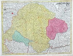
Carinthia Ducatus distincta in superiorem et inferior cum insertis Dominiis Ad Archiep. Salisurgens. et Episcop. Bambergensis pertinentibus nova mappa Geographica [.].
Published by Ausgburg [um 1762]., 1762
Seller: Antiquariat Burgverlag, Wien, Austria
Association Member: ILAB VDA VDAO
Seller rating 5 out of 5 stars
Altkolorierte Kupferstichkarte. ca. 50 x 65 cm. (Bildausschn.); 49,8 x 58, 5 cm (Plattengr.). Unter Passepartout. Sehr gut erhalten. Lexikon zur Geschichte der Kartographie, C2, S. 53 ff. - Altkolorierte Kupferstichkarte des Herzogtums K�rnten mit 2 Kartuschen, davon 1 mit einer Ansicht von Klagenfurt ("Clagenfurt"). Zeigt das Gebiet von Hochfilzen bis Tiliach und von Judenburg bis zum Kloster Michelstetten/ Velesovo mit dem "Feldes See" (Bleder See/Blejsko jezero) sowie u.a. dem W�rthersee ("Wert See") und dem Weissensee ("Wei� See"). Die Karte schuf Matth�us Seutter (1678-1757), nach dessen Tod �bernahm sein Schwiegersohn Tobias Lotter (1717-1777) einen Teil der Platten. Gewicht in Gramm: 1000.
-

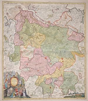
Delineatio Geographica Ditionis Martisburgensis?
Published by Artist: Lotter/ Seutter Tobias Conrad/Albrecht ( - 1777 ) Augsburg ca : 1720, 1717
Seller: Antique Sommer& Sapunaru KG, M�nchen, Germany
Seller rating 4 out of 5 stars
Technic: Copper print, colorit: original colored, condition: Very good, size (in cm): 49 x 57, Regional map of Merseburg - Halle - Leipzig (Saxony and Saxony-Anhalt).
-
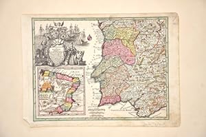
Portugalliae et Algarbiae Regna cu confin Hispan. Prov. ? Brasiliae Regn. in America.
Published by Artist: Lotter/ Seutter Tobias Conrad/Albrecht ( - 1777 ) Augsburg ca : 1740, 1717
Seller: Antique Sommer& Sapunaru KG, M�nchen, Germany
Seller rating 4 out of 5 stars
Technic: Copper print, colorit: original colored, condition: Perfect condition, size (in cm): 19,5 x 25,5 cm, Map shows Portugal, partly Spain, two magnificent cartouches with the coat of arms of the Kingdom of the Algarve and Portugal. On a partial map of Brazil with the Portuguese colonies.
-

Delineatio geographica ditiones Martisburgensis hodie regiis et electora libus.
Published by Artist: Lotter/ Seutter Tobias Conrad/Albrecht ( - 1777 ) Augsburg ca : 1720, 1717
Seller: Antique Sommer& Sapunaru KG, M�nchen, Germany
Seller rating 4 out of 5 stars
Technic: Copper print, colorit: original colored, condition: Very good, size (in cm): 48 x 57, Map shows the area of Merseburg in Sachsen- Anhalt with the cities of Halle, L�tzen and Leipzig.
-
Electoratus Hanoverani cum ditionibus et praefecturis suis nova et accurata delincurata
Published by Artist: Lotter/ Seutter Tobias Conrad/Albrecht ( - 1777 ) Augsburg ca : 1737, 1717
Seller: Antique Sommer& Sapunaru KG, M�nchen, Germany
Seller rating 4 out of 5 stars
Technic: Copper print, colorit: original colored, condition: Perfect condition, size (in cm): 57 x 49 cm, Map shows the Electorate of Hanover. On the lower left decorative title cartouche surrounded by Diana hunting, Vulcan in the forge, Apollo with the muses, putti, a bust and much more. The map was published on the occasion of the foundation of the Georg August University in G�ttingen in 1737.
-
Atlas
Publication Date: 1770
Seller: Arader Galleries - AraderNYC, New York, NY, U.S.A.
Seller rating 5 out of 5 stars
Hardcover. Condition: Good. Augsburg, C.1770-1775. Folio, (20 �" x 13 �"). With 38 engraved colored maps, likely from "Atlas novus sive tabulae geographicae totius orbis." Bound in contemporary half tan deer over mottled paper boards. Some marginal tears and tears along folds and crossing onto image on several maps, significantly so on maps 29 and 33. Maps 1 and 38 are loose from binding, some staining, significantly on maps 26 and 34). Cover and spine very worn with faded damaged spine. Provenance: Gustaf Odencrantz signature dated 1911 on front pastedown. BEAUTIFULLY ENGRAVED ATLAS WITH A EUROPEAN FOCUS. Most maps are of individual regions/states of Europe with a few maps in the rear dedicated to Asia, Middle East, Africa and North America. Seutter (1685-1757) established his own publishing house and print shop in 1710 and subsequently produced numerous maps, atlases and globes, few of which were original. Seutter made his own engravings based on the work of other cartographers. His most well known works were the "Atlas Geographicus order.", "Gross Atlas" and the "Atlas minor". His son-in-law was Tobias Lotter (1717-1777) who had married his oldest daughter. Lotter engraved many of Seutter's maps and took over the business in 1756; he went on to become one of the most famous cartographers of the eighteenth century German School. Bagrow, History of Cartography p.187, 189, 258, 272; Phillips, Atlases 593.
-
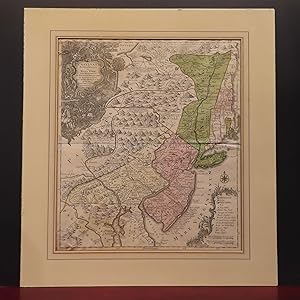
Pensylvania, Nova Jersey et Nova York cum Regionibus ad Fluvium Delaware in America Sitis nova delineatione ob oculos posita per Tob. Conr. Lotter, geographum Aug. Vind. Tob. Conr. Lotter sculps. Aug. V.
Published by Lotter circa 1760, Augsburg, 1760
Seller: William Chrisant & Sons, ABAA, ILAB. IOBA, ABA, Ephemera Society, Fort Lauderdale, FL, U.S.A.
Association Member: ABAA ESA ILAB
Seller rating 5 out of 5 stars
Condition: Very Good. Unusual rendering of New England with odd boundaries & including placement of Cape Cod & Boston in Connecticut. Nice original color. Trimmed at or near plate mark; occasional wear & discoloration to edges; dampstaining to lower left corner (see image); repair to verso of upper left corner; edges of verso taped to mat; still presents handsomely (see image).; 22 3/8 x 19 3/8 inches; 568 x 492 mm; All shipments through USPS insured Priority Mail.
-
Partie orientale de la Nouvelle France ou du Canada avec l'isle de Terre - Neuve et de Nouvelle Escosse, Acadie et Nouv. Angleterre avec Fleuve St. Laurence
Published by Augsburg, 1745
Seller: Alexandre Antique Prints, Maps & Books, Toronto, ON, Canada
Seller rating 4 out of 5 stars
Map
Condition: Very Good. Second State. Very unusual elongated map of the East coast of Canada. A beautiful map of Northeastern Canada, including Nova Scotia, Labrador and Newfoundland. This is the second state of the map originally drawn by Seutter and engraved by Lotter, with Lotter?s imprint. The map's vertical format elongates the geography and distorts Newfoundland. The St. Lawrence River runs nearly north-south. It is very detailed, especially along the coastlines and rivers. Many place names, both European and Indian. At bottom right is a scene with several sailing ships. At top left is a huge decorative title cartouche featuring allegorical figures, Indian chiefs, explorers, mapmakers, a fleet of ships, fishermen and wildlife. "The artwork and engraving are typical of the German school. Denied first-hand exploration information by the location of their country, the Germans, far from the sea, explore the world of fantasy with bold finesse, making imagery more imprtant than scientific fact. . The whole surface is cluttered with illustrations. It is difficult to find another map on this scale with so many small, well-drawn scenes."-Armstrong, Size : 585x499 (mm), 23x19.625 (Inches), Original Hand Coloring, 0.
-
Spatiosissimum Russiae Magnae juxta recentissimas Observationes Mappa Geographica accuratissime delineatum opera et sumtibus Tobiae Conradi Lotteri, Geogr. et Chalcogr. Augustae Vindel.
Published by Tobias Conrad Lotter c. 1757, Augsburg, 1757
Seller: Alexandre Antique Prints, Maps & Books, Toronto, ON, Canada
Seller rating 4 out of 5 stars
Map
Title cartouche in lower left depicts the shield of Russia, an Imperial solider, and two travelers. The lower right features a small legend., Size : 510x590 (mm), 20.08x23.23 (Inches), Hand Colored in Outline Minor browning along central fold, otherwise Very Good; laid down on acid-free tissue paper for long-term preservation.
-
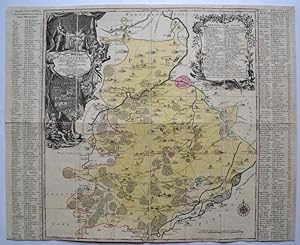
Praefecturae Saxonicae Wurcensis, Eilenburgensis, Dubensis, Geographica accuratione, secundum oppida, vicos, pagos, vinias descriptae, a Matthaeo Seuttero, S.C. M. Geogr. Aug. Vindel.
Published by Tobias Conrad Lotter c. 1750, Augsburg, 1750
Seller: Alexandre Antique Prints, Maps & Books, Toronto, ON, Canada
Seller rating 4 out of 5 stars
Condition: Very Good; This is a map of the wine region in Saxony, Germany., Size : 500x580 (mm), 19.69x22.83 (Inches), Original Hand Coloring.
-
Pagi Basileensis, qui pars esr republicae Helvetiorum cum adjacentibus terrarum tractibus nova eaque accurata mappa geographica concinnata opera et studio Matthaei Seutteri Georgraphi Caesarei Aug. Vindel.
Language: Latin
Published by Seutter, Matth�us, Augsburg, 1750, 1750
Seller: Antiquariat Carl Wegner, Berlin, B, Germany
Association Member: GIAQ
Seller rating 5 out of 5 stars
First Edition
Nicht gebunden. 57,5 : 49,5 cm Stichgr��e / 60,0 : 53,5 Blattgr��e. Altkolorierter Kupferstich von Tobias Conrad Lotter. Unten links im barocken Figuren-Schmuckemblem betitelt, unten rechts eine weitere fig�rliche Kartusche mit Ansicht der Stadt Basel, darunter mit dem Vermerk: Tob. Conr. Lotter sculps. Auf der Karte verteilt sieben kleine Wappen. Detaillierte Karte mit alter Grenzkolorierung. Das Blatt im oberen Rand mit bis zu 8 cm reinreichendem alten Feuchtrand. Auch sonst etwas gebr�unt. Insgesamt durchaus gut erhalten. -- 57.5 : 49.5 cm engraving size / 60.0 : 53.5 sheet size. Old colored copperplate engraving by Tobias Conrad Lotter. Titled lower left within a baroque figural ornamental emblem, lower right another figural cartouche with a view of the city of Basel, below with the note: Tob. Conr. Lotter sculps. Seven small coats of arms are distributed across the map. Detailed map with old border coloring. The upper margin of the sheet has an old wet margin extending up to 8 cm. Also slightly browned elsewhere. Overall, in very good condition. -- Gravure (57,5 x 49,5 cm) / feuille (60 x 53,5 cm). Ancienne gravure sur cuivre colori�e de Tobias Conrad Lotter. Titr�e en bas � gauche dans un embl�me ornemental figuratif baroque, en bas � droite dans un autre cartouche figuratif avec une vue de la ville de B�le, avec la mention en dessous : Tobias Conrad Lotter sculpte. Sept petites armoiries sont r�parties sur la carte. Carte d�taill�e avec ancienne coloration des bordures. La marge sup�rieure de la feuille pr�sente une ancienne marge humide s'�tendant jusqu'� 8 cm. L�g�rement brunie ailleurs. En tr�s bon �tat g�n�ral. -- Bitte Portokosten au�erhalb EU erfragen! / Please ask for postage costs outside EU! / S ' il vous plait demander des frais de port en dehors de l ' UE! // Bitte beachten Sie auch unsere Fotos! / Please also note our photos! / Veuillez noter nos photos -- Nehmen Sie sich ein gutes Buch mit auf die Sommerwiese. Bei uns werden Sie f�ndig! -- Wir kaufen Ihre werthaltigen B�cher! FL0799-319577.
-

S.R.I. Principat. et Archiepiscopatus Salisburgensis. Mappa geographica delineatus in qua Subjecta appertinent. finitima Regiones et Ditiones accuratiss. ob oculos ponuntur cura et studio Tob: Conrad Lotter, Geogr. Aug. Vind.
Language: Latin
Published by Augsburg, Lotter [zwischen 1760/1780], 1780
Art / Print / Poster
Altkolorierter Kupferstich. ca. 50 x 59 cm. Vgl. Schaup, S. 115: 3.4.1. - Randl�suren, mit hds. Nr. in linken oberen Ecke, mittig angeklebter Falz a. R�ckseite, Gbrsp.
![Seller image for [Composite Atlas] for sale by Barry Lawrence Ruderman](https://pictures.abebooks.com/inventory/md/md31941102311.jpg)
![Seller image for [Sachsen : Herzogtum Magdeburg u. Halle] : Ducatus Magdeburgensis et Halensis cum finitimis Delineatio geographica, curante Mattaeo Seuttero Geographo Caesar. Cum Priv. S. Reg. Polon. et Elect. Saxon [wohl: Privilegio Serenissimo Regis (K�nig) Poloniae et Electore (Kurf�rst) Saxoniae]. for sale by Franz K�hne Antiquariat und Kunsthandel](https://pictures.abebooks.com/inventory/md/md17503287569.jpg)

