
Order Total (1 Item Items):
Shipping Destination:

M�ndung (16 results)
Author:
m�ndung
Refine with Advanced Search
Skip to main search results
Search filters
Product Type
- All Product Types
- Books (4)
- Magazines & Periodicals (No further results match this refinement)
- Comics (No further results match this refinement)
- Sheet Music (No further results match this refinement)
- Art, Prints & Posters (7)
- Photographs (No further results match this refinement)
- Maps (5)
- Manuscripts & Paper Collectibles (No further results match this refinement)
Condition Learn more
- New (1)
- As New, Fine or Near Fine (No further results match this refinement)
- Very Good or Good (No further results match this refinement)
- Fair or Poor (No further results match this refinement)
- As Described (15)
Binding
Collectible Attributes
- First Edition (No further results match this refinement)
- Signed (No further results match this refinement)
- Dust Jacket (1)
- Seller-Supplied Images (12)
- Not Print on Demand (15)
Language (3)
Free Shipping
Seller Location
Seller Rating
-

Stahlstich aus Meyers Universum.
Language: German
Published by Hildburghausen um 1845., 1845
Art / Print / Poster
10,6 x 16,5 cm. Im wei�en Rand etwas stockfleckig. [SW - Ansicht, Ansichten, Rumanien].
-
US$ 18.44
Free Shipping
Ships from United Kingdom to U.S.A.Quantity: Over 20 available
Add to basketPaperback. Condition: New. Print on Demand. This book meticulously details plans for a new railway line between England and mainland Europe, connecting London with Germany via the Scheldt and Rhine rivers, offering a comprehensive overview of the project's potential benefits and economic impact. It highlights the advantages of this line for trade and travel, with a particular focus on the transport of goods and passengers between England and central Europe, as well as its role in facilitating access to eastern European markets. The author argues that this railway will revolutionize trade between Britain and Europe, providing a faster, more efficient, and more cost-effective means of transporting goods and people. Ultimately, this book makes a compelling case for the construction of this railway line, demonstrating its potential to transform trade and travel between Britain and the continent. This book is a reproduction of an important historical work, digitally reconstructed using state-of-the-art technology to preserve the original format. In rare cases, an imperfection in the original, such as a blemish or missing page, may be replicated in the book. print-on-demand item.
-

Zweibr�cken: G. Ritter, 1842. Reprint: Prestel-Verlag M�nchen, 1976. OHardc. im schwarzen, goldgepr�gten OPappschuber. 29 rot- u. schwarzgedruckte Bll. - 19,5 x 24. * Wohlerhaltene Wiedergabe des Erstdrucks nach dem Exemplar der Bayerischen Staatsbibliothek in M�nchen ! - Schuber ganz gering berieben.
-
83 (1) Seiten mit 13 Anlagen und 4 farbigen Faltkarten in Deckellasche, gr�nes Orig.-Leinen mit wei�er Typographie, 4�. - Hinteres Gelenk gelockert. Kommentar: *Erste Ausgabe. -.
-
".das herrliche Institut.". Die Geschichte der Kreissparkasse Weserm�nde-Hadeln und ihrer Vorg�nger-Institute 1837-1987. Mit mancherlei lokalen und regionalen Begebenheiten an Elb- und Weserm�ndung aus 150 Jahren von H. E. Hansen.
Language: German
Published by Bremerhaven KSK Weserm�nde-Hadeln, 1987
Seller: M�ller & Gr�ff e.K., Stuttgart, Germany
Association Member: GIAQ ILAB VDA
Seller rating 5 out of 5 stars

4�. 360 S. Mit tls. farb. Abb. Original-Pappband mit Schutzumschlag. 1 Ecke angesto�en, sonst gutes Exemplar. Gewicht (Gramm): 1760.
-

Ansicht m. zahlr. Schiffen, "Die M�ndung der Themse".
Language: German
Seller: Antiquariat Clemens Paulusch GmbH, Berlin, Germany
Seller rating 5 out of 5 stars
Art / Print / Poster
Stahlstich b. Bibliogr. Institut, 1863, 9,5 x 14,7.
-
Portr�t. Halbfigur. Original - Lithographie von Brandt nach A. Kneisel, Blattformat: 17,2 x 13 cm.
Seller: Antiquariat Michael Eschmann, Gro�-Gerau, Germany
Seller rating 5 out of 5 stars
Art / Print / Poster
0. Selten. - Blattr�nder beschnitten. - Gute Erhaltung. Sprache: Deutschu.
-

Senegal / Afrika / Westafrika.
Seller: Antiquariat Martin Barbian & Grund GbR, Saarbruecken, Germany
Seller rating 5 out of 5 stars
Art / Print / Poster
Altkolorierter Kupferstich aus " Schauplatz des gegenw�rtigen Kriegs ." bei Raspe, N�rnberg, um 1765. 21.5x36.5 cm.
-
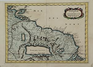
GUIANA in GUIANAM & CARIBANAM divisa.
Seller: Graphik-Antiquariat Jason D�ssel, Berlin, Germany
Seller rating 5 out of 5 stars
Art / Print / Poster
Kolorierter Kupferstich, Nicolas Sanson um 1690. 20 x 27 cm. Rechts am Rand ein 2,5 cm kleiner Einri�, hinterlegt mit reparaturband. Insgesamt gut erhalten. Zeigt das K�stengebiet Amazonas-M�ndung bis zum Golf von Paria mit Trinidad und Tobago.
-

Fort de la Volana - Village de la Ponpose - Chateau de la Mezzola - Port de Goro.
Language: German
Seller: Antiquariat Clemens Paulusch GmbH, Berlin, Germany
Seller rating 5 out of 5 stars
Art / Print / Poster
Kupferstich aus Roux, Recueil des principaux plans des ports et rades de la Mer Mediterran�e, 1764, 12,4 x 18,7.
-

Kupferstich- Karte, v. Bellin, "Carte du Golphe de St. Laurent et Pays Voisins".
Language: German
Seller: Antiquariat Clemens Paulusch GmbH, Berlin, Germany
Seller rating 5 out of 5 stars
Map
um 1760, 22 x 36 Zeigt dien St. Lorenz Golf und Neufundland.
-

Kupferstich- Karte, v. Bellin, "Karte von dem Laufe des Flusses St. Laurenz von seiner M�ndung an bis �ber Quebec".
Language: German
Seller: Antiquariat Clemens Paulusch GmbH, Berlin, Germany
Seller rating 5 out of 5 stars
Map
1758, 19 x 29,7 Zeigt das M�ndungsgebiet des St. Lorenzstromes, im Osten noch Quebec.
-

Lithografie- Karte, n. F.W. Streit b. J. Engelmann in Heidelberg, "Karte des Rheins von Linz bis zu seinen M�ndungen in die Nord- und Zuyder-See nebst der Maas von Maastricht bis zu ihrer M�ndung.".
Language: German
Seller: Antiquariat Clemens Paulusch GmbH, Berlin, Germany
Seller rating 5 out of 5 stars
Map
1840, 38 x 49,5 Schmidt, Rhein, 220. Aus der 5. Ausgabe von Schreiber, A. "Der Rhein. Handbuch f�r Reisende". Mit der �blichen alten Faltung.
-

Syrmien. Ausfluss der Nera in die Donau.
Language: German
Seller: Antiquariat Clemens Paulusch GmbH, Berlin, Germany
Seller rating 5 out of 5 stars
Art / Print / Poster
Lithographie v. Kunike aus Kunike, Donaustrom, 1826, 26 x 35 Nebehay-Wagner 336, 187. - Zeigt die M�ndung des Grenzflusses Nera (Hepa) zwischen Serbien und Rum�nien bei Palanka. Personen um eine Kochstelle im Vordergrund.
-

Kupferstich- Karte, v. Fricx b. Covens et Mortier, "Les embouchures de la Somme et de Bresle Riv. ou est St. Valeri, Eu et Dieppe",.
Language: German
Seller: Antiquariat Clemens Paulusch GmbH, Berlin, Germany
Seller rating 5 out of 5 stars
Map
mit altem Grenzkolorit, um 1745, 44,7 x 56 Blattgr. 57 x 68 Zeigt die K�ste der Normandie von Quiberville bis Crotoy. - Sauber und sehr gut erhalten.
-

Kupferstich- Karte, von 2 Platten gedruckt aus "Neptun francais", "Suite de la Carte R�duite du Folphe de St. Laurent Contenant Les Costes de Labrador, depuis Mecatina jusqu'a la Baye des Esquimaux .".
Language: German
Seller: Antiquariat Clemens Paulusch GmbH, Berlin, Germany
Seller rating 5 out of 5 stars
Map
dat. 1754, 86 x 53,5 (H) Oben links die prachtvolle Titelkartusche. Zeigt die "Detroit de Belle Isle", im S�den der n�rdl. Teil der Insel Neufundland, im Norden das kanadische Festland. - A detailed chart showing the entire coastline on Newfoundland and the adjacent Canadian mainland.

