
Order Total (1 Item Items):
Shipping Destination:

Mansfeld Ernst (73 results)
Skip to main search results
Search filters
Product Type
- All Product Types
- Books (64)
- Magazines & Periodicals (No further results match this refinement)
- Comics (No further results match this refinement)
- Sheet Music (No further results match this refinement)
- Art, Prints & Posters (8)
- Photographs (No further results match this refinement)
- Maps (No further results match this refinement)
- Manuscripts & Paper Collectibles (1)
Condition Learn more
Binding
Collectible Attributes
- First Edition (6)
- Signed (No further results match this refinement)
- Dust Jacket (No further results match this refinement)
- Seller-Supplied Images (60)
- Not Print on Demand (36)
Language (2)
Free Shipping
Seller Location
Seller Rating
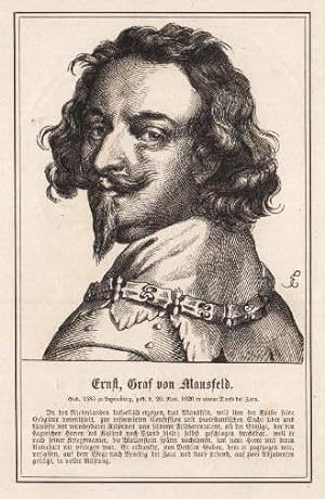
-

geb. 1580, gest. 19./20. November 1626. Brustbild.
Published by Holzstich bei Spamer, aus dem Jahr., 1878
Bildgr��e 7x5 cm.
-
15,0 x 9,5 cm. Unterhalb der Darstellung mit biographischen Angaben. Beidseitig bedruckt, R�ckseite mit Portr�t von Albrecht von Wallenstein. [SW - Portrait, Ernst von Mansfeld].
-
Jugendliche in der Berufsbew�hrung. Schriftenreihe aus dem Gebiete des �ffentlichen Gesundheitswesens. Heft 7
Published by Thieme, Stuttgart, 1958
Broschur. SEHR GUTES EXEMPLAR !, VIII, 179 S. m. Tab., Grafiken u. Abb. Size: 23 x 15 Cm. 550 Gr.
-

Portr�t. Original - Holzstich, 11 x 9 cm, 1857.
Seller: Antiquariat Michael Eschmann, Gro�-Gerau, Germany
Seller rating 5 out of 5 stars

Art / Print / Poster
0. Sprache: Deutschu.
-

Handw�rterbuch der Volkswirtschaft (German Edition)
Seller: Ria Christie Collections, Uxbridge, United Kingdom
Seller rating 5 out of 5 stars
US$ 63.18
US$ 16.09 shipping
Ships from United Kingdom to U.S.A.Quantity: Over 20 available
Add to basketCondition: New. In.
-

-

Observationes forenses varii argumenti.
Published by Leipzig, Langenheim, 1745
Seller: Wissenschaftliches Antiquariat K�ln Dr. Sebastian Peters UG, K�ln, Germany
Seller rating 5 out of 5 stars
First Edition
Condition: gut. Pr�ses: Johann Gottlieb Siegel; Disputatio: 1745-03-11; Widmung an: August Clamor von Busch; 2 Bl., 28 S., 21 x 17 cm, florale Vignette, florale Initiale, deutsche Einsch�be, Ecken geknickt, Titelblatt fleckig, Staubrand, papierbedingt gebr�unt. Sprache: Latin Erstausgabe.
-

-
Handw?rterbuch der Volkswirtschaft (German Edition)
Language: German
Published by Westdeutscher Verlag GmbH, 1978
ISBN 10: 3663000753 ISBN 13: 9783663000754
Condition: New. pp. 874.
-

Die Christlichen Jahrhunderte, Part 4
Language: German
Published by Kessinger Publishing, LLC, 2009
ISBN 10: 1104858606 ISBN 13: 9781104858605
Condition: New. KlappentextrnrnThis scarce antiquarian book is a facsimile reprint of the original. Due to its age, it may contain imperfections such as marks, notations, marginalia and flawed pages. Because we believe this work is culturally important, we have.
-
Brevis Notitia Urbis Veteris Vindobonae ex Variis Docvmentis Collecta Iosepho II Romanorvm Regi Semper Avgvsto ab Avstriaca Iesv Societate in Aeternae Observantiae Monvmentvm Oblata
Published by Vindobonae [Vienna] : Ioannis Thomae Trattner, 1764
First Edition
Johann Ernst Mansfeld (1739-1796) (illustrator). First Edition. ~ Engraved portrait frontispiece by Mansfeld, 1 heading cut depicting a view of Vienna, capital letters, 1 folded map of Vienna 1547, 10 leaves of genealogy tables (fold) ~ A History of Vienna since the Romans to the XVIIIth century, written by the Jesuit priest Leopold Fischer and published anonymously ~ Contemporary leather partially rebacked with paper at a later date, preserving old spine and corners ~ [34]+257+[1]p+1 blank leaf - Sign: X- XXXX4, A-Z4, Aa-Kk4 [Kk4 blank]. Catchwords on all pages ~ 24x21x4cm. ~ Joints partially broken, some slight wear at spine, occasional light browning and spotting, some minimal worming affecting frontis and text of first leaves ~ LANGUAGE: Latina / Additional images available/// We accept PayPal & EU bank transfer in EUROS //.
-

Brevis notitia urbis veteris Vindobonae ex variis documentis collecta Iosepho II, Romanorum Regi semper Augusto ab Austriaca Iesu societate in aeternae observantiae monumentum oblata.
Published by Wien, Trattner 1764., 1764
Seller: Antiquariat L�cker, Wien, Austria
Association Member: GIAQ ILAB VDA VDAO
Seller rating 5 out of 5 stars
First Edition
Erste Ausgabe. Eine Geschichte Wiens von den R�mern bis zum XVIII. Jahrhundert, verfasst durch den Jesuitenpater Leopold Fischer und anonym ver�ffentlicht, gewidmet Josef II., dessen Portr�t das Frontispiz zeigt; der detaillierte Wienplan nach Hirschvogel samt Erl�uterungen gilt heute als grundlegend zur Dokumentation Wiens.- Gugitz 18; Mayer 82; Giese 630; de Backer III,756. kl.-4�. Tit.-Kupfer, 16 Bl., 257 (1) Seiten. Gestochenes Portr�t-Frontispiz, 1 gest. Ansicht von Wien, 1 mehrfach gef. Vogelschau-Plan von Wien (nach Augustin Hirschvogel, 1547), 10 Faltbl. mit angefalzten Ahnentafeln. Lederband d. Zt. mit reicher Deckel- u. R�ckengoldpr�gung, umlauf. Goldschnitt. Kap. berieben, Vorsatzbl. u. Falze der Ahnentaf. mit alten Wurml�chern.
-
Warhaffter Bericht von der Belagerung und mit Gesturmter Hand Eroberung der Stadt Pilsen inn Behem.
Published by Simon Halbmayer, Nuremberg, 1619
Seller: Sanctuary Books, A.B.A.A., New York, NY, U.S.A.
Seller rating 5 out of 5 stars
Hardcover. Condition: Near Fine. Small quarto. Full modern brown calf. 57 pp. Large folding engraved city plan at front. A very nice copy in a handsome binding.
-

"Post Charte der Kaiserl. K�nigl. Erblanden. Durch Herrn Abbe Georg Ignaz Freyherrn von Mezburg".- In 4 Kartenbl�ttern, mit gro�er figuraler Titelkartusche, einer Zierrandleiste und einer "postalischen" Legende.
Published by Wien 1787., 1787
Seller: Antiquariat MEINDL & SULZMANN OG, Wien - Vienna, Austria
Seller rating 5 out of 5 stars
Je ca. 50 x 75 cm, Gesamtgr��e ca. 100 x 150 cm. D�rflinger, Die �st. Kartographie I, 1984, 82 ff. Kat. Austria Picta, S. 100 u. S. 328, Nr. 27.3.- Neuauflage der gro�formatigen und seltenen ersten �sterreichischen Postkarte, vorliegend nicht auf Leinen aufgezogen, wie es seinerzeit f�r diese Karte gro�teils vorgesehen war. Erstmals 1782 erschienen. ".Die erste Karte der gesamten Monarchie nach mehr als einem halben Jahrhundert und zugleich die erste thematische Karte des Habsburgerstaates �berhaupt war die vierbl�ttrige 'Post Charte der Kaiserl. K�nigl. Erblanden' (ca. 1 : 1,3 Mill.; 1782) des Wiener Mathematikprofessors Georg Ignaz von Metzburg (1735-1798)." (Austria Picta S. 100). ". Sie enth�lt 'nebst allen kais. k�n. Erbl�ndern gegen Mittag Italien bis Rom, gegen Niedergang Frankreich nach Paris, gegen Mitternacht Deutschland bis Berlin, und gegen Aufgang die Moldau bis Jassy, so da� man die �brigen deutschen Postcharten leicht entbehren kann', hei�t es in einem zeitgen�ssischen Prospekt." (Austria Picta S. 328). ". Das gro�formatige Kartenwerk Metzburgs mit seiner pr�chtig ausgestalteten Titelkartusche (Szenen aus dem Postverkehr) war wohl weniger f�r den Postreisenden selbst gedacht, sondern sollte in erster Linie Poststationen, Handelskontoren und �hnlichen Stellen als informativer, zugleich jedoch auch als repr�sentativer Wandschmuck dienen. Nachdem Metzburg, der die Karte in Eigenregie vertrieb, mindestens eine, den Ver�nderungen im Postliniennetz Rechnung tragende Neuauflage (1787) herausgegeben hatte, gingen die Kupferplatten nach seinem Tod in den Besitz der Firma Artaria." (D�rflinger S. 83).- Kr�ftiger Abdruck, in der Darstellung tls. etw. braunfleckig. Beim vierten Kartenblatt (Bosnien, Serbien, Ungarn, Walachei) leider 2 gro�e Fehlstellen, die zeitgen�ssisch mit Papier hinterlegt und erg�nzt wurden.
-
Historischer Grundriss der Kais.-K�n. Haupt- und Residenz-Stadt Wien von den �ltesten Zeiten ihrer Entstehung bis auf gegenw�rtige glorreiche Regierung Seiner K. K. Majest�t Franz des II. mit allen Merkw�rdigkeiten und Versch�nerungen im Jahr 1802. Plans anciens et moderne de la Ville et residence I. et R. de Vienne pour Servir � l`essai historique et � la description de cette Capitale. Gestochen von Johan Mansfeld.
Published by Wien 1802., 1802
Seller: Antiquariat L�cker, Wien, Austria
Association Member: GIAQ ILAB VDA VDAO
Seller rating 5 out of 5 stars
First Edition
Erste Ausgabe. Mit Geb�udekennzeichnung u. Erl�uterungen zur Stadtentwicklung. - D�rflinger S. 404. Ca 49,5 x 66 cm, Ma�stab ca 1:3328. Kol. Kupferstich, in 18 Segmenten auf Leinen montiert. Mit 2 Nebenkarten: Erster Grundriss der Stadt Vien oder Vindobona. Grundriss der Stadt Wien zur Zeit der ersten t�rkischen Belagerung im Jahr 1529. In Orig.-Pappschuber mit Titelschildchen, Karte mit nur wenigen, kleinen, Stockflecken, der Schuber etwas berieben.
-
Versuch �ber die nat�rliche und politische Geschichte der b�hmischen und m�hrischen Bergwerke. I. Theil; II. Theil
Published by Wien: Gedruckt bey Matthias Andreas Schmidt, Universit�ts Buchdruckern 1780, 1780
Seller: Antikvariat Valentinska, Praha, Czech Republic
Association Member: ILAB
Seller rating 5 out of 5 stars
First Edition
US$ 1,363.21
US$ 30.77 shipping
Ships from Czech Republic to U.S.A.Quantity: 1 available
Add to basket"The Natural and Political History of Bohemian and Moravian Mines"; both parts of the first edition of a seminal work by Johann Thadd�us Anton Peithner, Edler von Lichtenfels (1727-1792), a renowned geologist and scientist. The author focuses not only on mines and their geology and history but also on Czech and Moravian rivers. Ancient statutes of Bohemian kings are also included, some of them in Latin (the rest of book is written in German). The book contains a fold-out map of the Iglau and Deutschbrod region (with an etching), an engraved title page and 15 large original etchings/vignettes (scenes from miners' life, portraits of kings and aristocrats, coins, coats of arms etc.), made by Jacob (Jakob) Adam (1748-1811) or Johann Ernst Mansfeld (1739-1796). /// Half-parchment binding with parchment corners, raised bands and gilt title; hardback, XX, 464, [34] pp., 1 map, 2� (24.5 x 37.5 cm); cover slightly worn, coated with a thin layer of glue, backstrip slightly cracked; new bookplate on front endpaper, another new bookplate on back endpaper; several pages with traces of dust; pages only slightly yellowed; deckle edges; condition: very good Book Language/s: German, Latin.
-
Tyrolis sub felici regimine Mariae Theresiae Rom. Imper. Aug. chorographice delineate a Petro Anich et Blasio Hueber . Viennae 1774.
Published by Vienna: The authors, 1774., 1774
Seller: Arader Galleries - AraderNYC, New York, NY, U.S.A.
Seller rating 5 out of 5 stars
First Edition
Quarter Leather. Condition: Very Good. 1st Edition. Folio (59 x 86 cm.): title from banner/scroll on "Tyrol gegen Suden" map; key sheet plus 20 sheets joined as four sections. Bound in contemporary quarter sheep over blue paste paper boards, leather label "Carte du Tyrol" and oval leather label with initials "M.G."; binding scuffed, especially spine, and a few wormholes. ORIGINAL EDITION OF ANICH AND HUEBER'S TYROL WALL-MAP, THE MOST ACCURATE TO DATE AND THE STANDARD WELL INTO THE 19TH CENTURY. Full engraved title: "Tyrolis sub felici regimine Mariae Theresiae Rom. Imper. Aug. chorographice delineate a Petro Anich et Blasio Hueber Colonis oberperfussianis curante Ignat. Weinhart Profess. Math. in Univers. Oenipontaria. Aeri incise a Ioa. Erneste Mansfeld, Viennae 1774." Ignaz Weinhart S.J., Austrian Jesuit and professor of mathematics and physics at the University of Innsbruck, was the brainchild behind the first geographic survey of the Tyrol. Weinhart acted as mentor and teacher to Peter Anich and Blasius Hueber, who served as the principal cartographers of the project; Johann Ernst Mansfeld was the engraver. Weinhart met Anich in 1751 and immediately recognized his surveying and cartographic talents. Anich and Heuber conducted their survey of the Tyrol over several years, from 1760 to 1774, with Weinhart supervising their activity. The fruit of their long collaborative efforts--the 20-part map of north and south Tyrol--was the first accurate land survey of the region and became the model for later surveying in the field of military geography. REFERENCES: R.V. Tooley, Maps and Map-makers, p. 27. Book.
-

Ducreux, G: Christlichen Jahrhunderte, Part 4
Language: German
Published by Kessinger Publishing, LLC, 2009
ISBN 10: 1104858606 ISBN 13: 9781104858605
Taschenbuch. Condition: Neu. Neuware - This scarce antiquarian book is a facsimile reprint of the original. Due to its age, it may contain imperfections such as marks, notations, marginalia and flawed pages. Because we believe this work is culturally important, we have made it available as part of our commitment for protecting, preserving, and promoting the world's literature in affordable, high quality, modern editions that are true to the original work.
-
Kr�ssmann, Walter: Ernst von Mansfeld (1580-1626). Grafensohn, S�ldnerf�hrer, Kriegsunternehmer gegen Habsburg im Drei�igj�hrigen Krieg. Berlin, Dunker & Humblot, 2010. Mit Titelportr�t, 742 S., OKart.; gutes Expl. (= Historische Forschungen, 94). - P.E.v.Mansfeld (1580 Luxemburg-1626 Sarajewo) war als privater Kriegsunternehmer in herrschaftl.Diensten u.der Protestantischen Union 1620-26 einer der f�hrenden S�ldnergener�le gegen Habsburg u.dessen Verb�ndete im Drei�igj�hrigen Krieg.
Seller: Wissenschaftliches Antiquariat Mayrhofer, P�rbach, Austria
Seller rating 5 out of 5 stars
Kr�ssmann, Walter: Ernst von Mansfeld (1580-1626). Grafensohn, S�ldnerf�hrer, Kriegsunternehmer gegen Habsburg im Drei�igj�hrigen Krieg. Berlin, Dunker & Humblot, 2010. Mit Titelportr�t, 742 S., OKart.; gutes Expl. (= Historische Forschungen, 94). - P.E.v.Mansfeld (1580 Luxemburg-1626 Sarajewo) war als privater Kriegsunternehmer in herrschaftl.Diensten u.der Protestantischen Union 1620-26 einer der f�hrenden S�ldnergener�le gegen Habsburg u.dessen Verb�ndete im Drei�igj�hrigen Krieg.
-
![Seller image for Edictalis (Cassatio electionis Gabrielis Betlen etc.) Edictal-Cassation der Wahl Gabriel Bethlens zum Konig von Ungarn, neben angehengten Annulation aller derjenigen Arten und Handlungen, so auff den zusammenkunfften zur Preburg vnd Newen Pol beschlossen worden. Item Copey eines Schreibens so der Graf von Mansfeld an den Bethlem Gabor soll gethan haben 1621 [LeatherBound] for sale by True World of Books](https://pictures.abebooks.com/inventory/md/md31617354732.jpg)
LeatherBound. Condition: New. BOOKS ARE EXEMPT FROM IMPORT DUTIES AND TARIFFS; NO EXTRA CHARGES APPLY. LeatherBound edition. Condition: New. Reprinted from 1621 edition. Leather Binding on Spine and Corners with Golden leaf printing on spine. Bound in genuine leather with Satin ribbon page markers and Spine with raised gilt bands. A perfect gift for your loved ones. Pages: 29 NO changes have been made to the original text. This is NOT a retyped or an ocr'd reprint. Illustrations, Index, if any, are included in black and white. Each page is checked manually before printing. As this print on demand book is reprinted from a very old book, there could be some missing or flawed pages, but we always try to make the book as complete as possible. Fold-outs, if any, are not part of the book. If the original book was published in multiple volumes then this reprint is of only one volume, not the whole set. Sewing binding for longer life, where the book block is actually sewn (smythe sewn/section sewn) with thread before binding which results in a more durable type of binding. Pages: 29.
-
Bataille de Tunis entre Xantippe et Regulus
Published by Tunisi - Tunisia
Seller: Sergio Trippini, Gavirate, VA, Italy
Seller rating 4 out of 5 stars

Raffigurazione dello schieramento militare. Pieghe editoriali.
-
Bataille d'Antioche soter contre les Galates
Published by Antiochia
Seller: Sergio Trippini, Gavirate, VA, Italy
Seller rating 4 out of 5 stars
Raffigurazione dello schieramento militare. Pieghe editoriali.
-
Leopoldus Comes a Daun Austriaci Exercitus Supremus Dux.
Published by Leopoldus Comes
Seller: Sergio Trippini, Gavirate, VA, Italy
Seller rating 4 out of 5 stars
Ritratto in ovale.
-

Portr�t. Brustbild. Kupferstich von C. P. Landon nach van Dyck, 17 x 10 cm, 1806.
Seller: Antiquariat Michael Eschmann, Gro�-Gerau, Germany
Seller rating 5 out of 5 stars
Art / Print / Poster
0. Sprache: Deutschu.
-
Ordre de bataille de Mantin�e
Published by Mantinea - Grecia
Seller: Sergio Trippini, Gavirate, VA, Italy
Seller rating 4 out of 5 stars
Raffigurazione dello schieramento militare. Pieghe editoriali.
-
Camp de Denain ordre sur le quel lauteur auroit propose de combattre
Published by Denain - Francia
Seller: Sergio Trippini, Gavirate, VA, Italy
Seller rating 4 out of 5 stars
Raffigurazione di schieramento militare. Pieghe editoriali.
-
Ordre de bataille des imperiaux et des Suedois a Lutzen
Published by L�tzen - Sassonia
Seller: Sergio Trippini, Gavirate, VA, Italy
Seller rating 4 out of 5 stars
Piano della battaglia. Pieghe editoriali.
-
Ordre de bataille de Leuctres
Published by Leuctres - Boezia - Grecia
Seller: Sergio Trippini, Gavirate, VA, Italy
Seller rating 4 out of 5 stars
Raffigurazione dello schieramento militare. Pieghe editoriali.
-
Blocus et bataille d'Agrigente
Published by Agrigento
Seller: Sergio Trippini, Gavirate, VA, Italy
Seller rating 4 out of 5 stars
Piano della battaglia e veduta della citt�. Pieghe editoriali.
-
![Seller image for Grundriss und Durchschnitt zwoer Schleusen um die Bewegungsart zu zeigen wie ein Schiff sich stuffenweise zu gewissen Hoehen erheben und ebenso wieder abwaerts gehen koenne. - Plan et Coupe de deux Ecluses a l �ffet de montrer par quel mecanisme un Bateau peut s �lever graduellement � de certaines hauteurs et en descendre - [Kupferstich]. - for sale by Antiquariat Tautenhahn](https://pictures.abebooks.com/inventory/md/md30775702900.jpg)
Grundriss und Durchschnitt zwoer Schleusen um die Bewegungsart zu zeigen wie ein Schiff sich stuffenweise zu gewissen Hoehen erheben und ebenso wieder abwaerts gehen koenne. - Plan et Coupe de deux Ecluses a l �ffet de montrer par quel mecanisme un Bateau peut s �lever graduellement � de certaines hauteurs et en descendre - [Kupferstich]. -
Published by [Wien: C. & F. Bargum um 1785], 1785
Seller: Antiquariat Tautenhahn, L�beck, Germany
Association Member: GIAQ ILAB VDA
Seller rating 5 out of 5 stars
Art / Print / Poster
Kupferstich, Blattma�: 40 x 52 cm (quer), Bildma�: 37 x 49 cm (quer). Der Kupferstich von Mansfeld ? (1738-1796), nach der Zeichnung des franz�sischen Wasserbauingenieurs Francois Joseph Maire, zeigt drei Abbildungen auf einem Blatt: Grundriss und L�ngsschnitt der Schleusen und einen Schnitt durch die Wasserleitung. Mit franz�sischem und deutschem Titel jeweils im unteren linken, bzw. rechten Bilddrittel. Der Ma�stab am unteren Bildrand ist in Schuhen (pieds) angegeben. - Das Blatt ist anger�ndert, fleckig und etwas gebr�unt. Sonst ordentliches Exemplar in detaillierter Zeichnung.


