Order Total (1 Item Items):
Shipping Destination:

Map Australia (77 results)
Skip to main search results
Search filters
Product Type
- All Product Types
- Books (24)
- Magazines & Periodicals (No further results match this refinement)
- Comics (No further results match this refinement)
- Sheet Music (No further results match this refinement)
- Art, Prints & Posters (No further results match this refinement)
- Photographs (No further results match this refinement)
- Maps (53)
- Manuscripts & Paper Collectibles (No further results match this refinement)
Condition Learn more
- New (3)
- As New, Fine or Near Fine (2)
- Very Good or Good (16)
- Fair or Poor (No further results match this refinement)
- As Described (56)
Binding
Collectible Attributes
- First Edition (11)
- Signed (2)
- Dust Jacket (No further results match this refinement)
- Seller-Supplied Images (60)
- Not Print on Demand (77)
Language (2)
Free Shipping
- Free Shipping to U.S.A. (No further results match this refinement)
Seller Location
Seller Rating
-

AUSTRALIA, AN ANTIQUE MAP, CIRCA 1860
Language: English
Published by GEORGE VIRTUE, Edinburgh, 1837
Seller: K Books Ltd ABA ILAB, York, YORKS, United Kingdom
Association Member: ABA ILAB PBFA
Seller rating 5 out of 5 stars

First Edition
US$ 17.82
US$ 26.14 shipping
Ships from United Kingdom to U.S.A.Quantity: 1 available
Add to basketSingle Sheet Engraving. Condition: Very Good. No Jacket. J DOWER (illustrator). First Edition. AUSTRALIA, AN ANTIQUE MAP, CIRCA 1860 A VERY GOOD MAP . VERY REASONABLY PRICED, . MEASURES 10 X 8 INCHES, 30 X 22 CMS, WELL PACKED MOUNTED AND READY TO FRAME, SEEMS VERY FEW TOWNS MENTIONED OTHE THAN ROUND THE COAST, VERY GOOD CONDITION, SPLENDID VALUE.
-
AUSTRALIA, DETAILED MAP, CIRCA 1860
Language: English
Published by LONDON PRINTING COMPANY, London, 1860
Seller: K Books Ltd ABA ILAB, York, YORKS, United Kingdom
Association Member: ABA ILAB PBFA
Seller rating 5 out of 5 stars
First Edition
US$ 27.48
US$ 26.14 shipping
Ships from United Kingdom to U.S.A.Quantity: 1 available
Add to basketSingle Sheet Engraving. Condition: Very Good. No Jacket. First Edition. AUSTRALIA, DETAILED MAP, CIRCA 1860 , good condition, very detailed, too large to mount so would dispatch rolled in a strong tube . MEASURES 14 X 10 INCHES, 36 X 25 CMS .
-
Australia - an Antique Map
Language: English
Published by London, 1890
Seller: K Books Ltd ABA ILAB, York, YORKS, United Kingdom
Association Member: ABA ILAB PBFA
Seller rating 5 out of 5 stars
US$ 20.71
US$ 26.14 shipping
Ships from United Kingdom to U.S.A.Quantity: 1 available
Add to basketNo Binding. Condition: Very Good. An attractive coloured map - excellent condition . mounted - matted - and ready to frame. Mount size approx 9 x 7 inches , 27 x 21 cms. Circa 1890 , An excellent map of .Australia.
-
THE COMMONWEALTH OF AUSTRALIA - an Original Coloured Map, Printed C1908
Language: English
Published by George Philip & Son/The London Geographical Institute, London, 1908
Seller: K Books Ltd ABA ILAB, York, YORKS, United Kingdom
Association Member: ABA ILAB PBFA
Seller rating 5 out of 5 stars
US$ 27.62
US$ 26.14 shipping
Ships from United Kingdom to U.S.A.Quantity: 1 available
Add to basketNo Binding. Condition: Very Good. An original map, printed in full colour, central fold. A map of Australia, with a population density map inset showing inhabitants per square mile, and a map of Tasmania also inset.
-
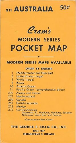
Cram's Modern Series Pocket Map #311 - Australia
Published by George F. Cram Co. Inc. nd, Indianapolis
Seller: Antipodean Books, Maps & Prints, ABAA, Garrison, NY, U.S.A.
Association Member: ABAA ANZAAB ESA ILAB
Seller rating 3 out of 5 stars

Condition: Fine. The map is tipped into its original, 8 �" x 4 �", yellow wrapper that lists the available Modern Series Maps offered by the Cram company on both sides. The colored map unfolds to 16" x 22". A small map on Tasmania is inserted at upper left corner. Someone has used a black marker throughout the Western Australia portion of the map to denote eucalyptus forests, savannah, desert, mallee, and mulga.
-
Australia - an Original Map Circa 1890
Language: English
Publication Date: 1890
Seller: K Books Ltd ABA ILAB, York, YORKS, United Kingdom
Association Member: ABA ILAB PBFA
Seller rating 5 out of 5 stars
US$ 20.71
US$ 26.14 shipping
Ships from United Kingdom to U.S.A.Quantity: 1 available
Add to basketNo Binding. Condition: Very Good. An original antique map of Australia - Victoria Region . Mounted - matted - and ready to frame. Mount size approx 14 x 12 inches , 42 x 36 cms . Very good condition. Circa 1890. Shows - in colour - a map of the Victoria Region in Australia.
-
AUSTRALIA, AN ANTIQUE MAP - an Original Antique MAP
Language: English
Publication Date: 1866
Seller: K Books Ltd ABA ILAB, York, YORKS, United Kingdom
Association Member: ABA ILAB PBFA
Seller rating 5 out of 5 stars
US$ 24.86
US$ 26.14 shipping
Ships from United Kingdom to U.S.A.Quantity: 1 available
Add to basketNo Binding. Condition: Very Good. An original antique coloured map printed in 1866. Mounted (matted) and ready to frame. Very good condition. AN EARLY MAP , IN GOOD CONDITION, MOUNT SIZE 12 X 14 INCHES, 34 X 38 CMS THE MAP SHOWS AUSTRALIA IN 1866.
-
Map of Australia - an Original Engraving
Language: English
Seller: K Books Ltd ABA ILAB, York, YORKS, United Kingdom
Association Member: ABA ILAB PBFA
Seller rating 5 out of 5 stars
US$ 27.62
US$ 26.14 shipping
Ships from United Kingdom to U.S.A.Quantity: 1 available
Add to basketNo Binding. Condition: Very Good. A fine Engraving - printed circa 1870. Mounted and ready to frame. A fine opportunity to purchase an attractive and decorative engraved Map of Australia.
-

Philippine social history: Global trade and local transformations (Southeast Asia publications series)
Language: English
Published by Ateneo de Manila University Press, 1900
ISBN 10: 9710200062 ISBN 13: 9789710200061
US$ 37.28
US$ 69.92 shipping
Ships from United Kingdom to U.S.A.Quantity: 1 available
Add to basketSoft cover. Condition: Good. Map (illustrator). good.
-

Understanding Traffic Systems
Language: English
Published by Ashgate Publishing Company, 2000
ISBN 10: 0754612481 ISBN 13: 9780754612483
US$ 225.24
US$ 8.71 shipping
Ships from United Kingdom to U.S.A.Quantity: 3 available
Add to basketCondition: New. pp. 484 60 Figures, Illus.
-
Understanding Traffic Systems
Language: English
Published by Ashgate Publishing Company, 2000
ISBN 10: 0754612481 ISBN 13: 9780754612483
Condition: New. pp. 484 2nd Edition.
-
Understanding Traffic Systems
Language: English
Published by Ashgate Publishing Company, 2000
ISBN 10: 0754612481 ISBN 13: 9780754612483
Condition: New. pp. 484.
-

Whitehead's New Map of Victoria, with Alphabetical Key
Language: English
Published by E Whitehead, Melbourne, 1874
Seller: Anah Dunsheath RareBooks ABA ANZAAB ILAB, Auckland, NZ, New Zealand
Association Member: ABA ANZAAB ILAB
Seller rating 5 out of 5 stars
Map
Soft cover. Condition: Very Good. Original linen backed map. 56 x 87 cm, folding into cloth covers 20 x 14 cm. Both map and cloth in very good condition.
-
Indian Ocean, India and Australia Etc - an Antique Map
Language: English
Seller: K Books Ltd ABA ILAB, York, YORKS, United Kingdom
Association Member: ABA ILAB PBFA
Seller rating 5 out of 5 stars
US$ 55.24
US$ 26.14 shipping
Ships from United Kingdom to U.S.A.Quantity: 1 available
Add to basketNo Binding. Condition: Very Good. Engraved By Walker (illustrator). A fine antique map - printed in 1844. Mounted (matted) and ready to frame. Engraved Size 12 x 10 Ins, 30 x 26 Cms. Mounted size approx 15 x 13 ins, 38 x 33cms. Coloured in outline, hand colouring contemporary. A fine opportunity to purchase an attractive and decorative engraved antique map of the Indian Ocean, India and Australia Etc.
-
MAP OF PART OF SOUTH AUSTRALIA Centred Round Spencer Gulf
Language: English
Published by JOHN TALLIS, LONDON, 1850
Seller: K Books Ltd ABA ILAB, York, YORKS, United Kingdom
Association Member: ABA ILAB PBFA
Seller rating 5 out of 5 stars
US$ 117.38
US$ 26.14 shipping
Ships from United Kingdom to U.S.A.Quantity: 1 available
Add to basketNo Binding. Condition: Very Good. H WARREN. J ROGERS J RAPKIN (illustrator). Antique map . Hand coloured, engraved map. mounted - matted - and ready to frame .10 x 13 inches. a vg copy of an attractive decorative hand coloured antique map. . A splendid map, colouring not contemporary but delicately and expertly done - a fine map of part of South Australia with colour washed vignettes of Adelaide, the seal of South Australia, a dingo, aborigines on a Catamaran and a bird called a Nymphicus.
-
Western Australia and Van Diemen Island - Showing Swan River, King George's Sound, Etc - an Antique Map
Language: English
Seller: K Books Ltd ABA ILAB, York, YORKS, United Kingdom
Association Member: ABA ILAB PBFA
Seller rating 5 out of 5 stars
US$ 62.14
US$ 26.14 shipping
Ships from United Kingdom to U.S.A.Quantity: 1 available
Add to basketNo Binding. Condition: Very Good. Engraved By Walker (illustrator). A fine antique map in very good condition - printed in circa 1844. Mounted (matted) and ready to frame. Engraved size approx 16 x 13 Ins, 41 x 33 Cms. Mounted size approx 19 x 16 in, 49 x 41cm. Coloured in outline, hand colouring contemporary. A fine engraved map of Western Australia and Van Diemen Island - Showing Swan River, King George's Sound, Etc.
-
MAP OF VICTORIA, OR PORT PHILLIP, AUSTRALIA.
Language: English
Published by JOHN TALLIS, LONDON, 1850
Seller: K Books Ltd ABA ILAB, York, YORKS, United Kingdom
Association Member: ABA ILAB PBFA
Seller rating 5 out of 5 stars
US$ 138.09
US$ 26.14 shipping
Ships from United Kingdom to U.S.A.Quantity: 1 available
Add to basketNo Binding. Condition: Very Good. A WARREN. J ROGERS J RAPKIN (illustrator). Antique map . Hand coloured, engraved map. mounted - matted - and ready to frame .10 x 13 inches. a vg copy of an attractive decorative hand coloured antique map. . A splendid map, colouring not contemporary but delicately and expertly done - a fine map of Victoria or Port Phillip, with colour washed vignettes of kangaroos, aborigines, Melbourne and the River Glenelg.
-
MAP OF NEW SOUTH WALES, AUSTRALIA.
Language: English
Published by JOHN TALLIS, LONDON, 1850
Seller: K Books Ltd ABA ILAB, York, YORKS, United Kingdom
Association Member: ABA ILAB PBFA
Seller rating 5 out of 5 stars
US$ 138.09
US$ 26.14 shipping
Ships from United Kingdom to U.S.A.Quantity: 1 available
Add to basketNo Binding. Condition: Very Good. H WARREN. J ROGERS J RAPKIN (illustrator). Antique map . Hand coloured, engraved map. mounted - matted - and ready to frame .10 x 13 inches. a vg copy of an attractive decorative hand coloured antique map. . A splendid map, colouring not contemporary but delicately and expertly done - a fine map of New South Wales, Australia with colour washed vignettes of the Murray River, Sydney Cove and a Xanthorrhaea plant.
-
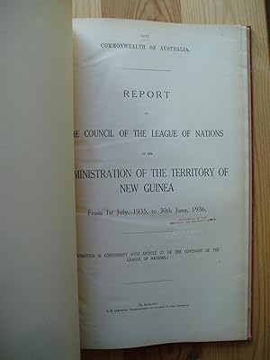
Report to the Council of the League of Nations on the Administration of the Territory of New Guinea.1 Jule 1935 - 30 June 1936
Published by L.F. Johnston, Govt. Printer, Canberra, 1937
Seller: Expatriate Bookshop of Denmark, Svendborg, Denmark
Seller rating 5 out of 5 stars
Binder's cloth. Textual tables, folding map (illustrator). 33x20cm, 130 pp, Rubberstamps to flyleaf & title-page. Cardpocket to rear fixed flyleaf. A small waterstain to the page-corner margin of the last 82 pages. Contents: Introductory; Administration; Law & Justice; Native Affgairs & District Administration; Native Labour; Arms, Liquor & Dangerous Drugs; Education; Public Health; Agriculture; Commerce; Public Finance; Lands, Surveys, Mines & Forests; Public Works; Immigration & Emigration; Freedom of Conscvience & Religiousd Missions; Miscellanrous; Appendices. Light water stain to binding, Good+.
-
Bibliomappe du premier age. G�ographie de la jeunesse.
Published by Paris, Bureau du Bibliomappes, 1827., 1827
circa 19,3 x 13 cm. XVI, 212 pp., 8 (or 9 on 8?) folding coloured engraved maps Contemporary half-leather with gilt spine "Introduction into geography for children with 8 nice coloured maps. The title says "avec neuf cartes" but we cannot trace copies that really have 9 maps, in fact most seem to have less than 8 - possibly the 2 hemispheres on the large plate of the worldmap count as two maps, which would make it 9 on 8 plates. Our copy contains: a worldmap, Europe, Asia, Africa, North-America, South-America, Australia with Oceania and France - there is no indication of another missing map. " - Just a little rubbed, clean inside, maps in nice colour.
-
Philips' Series of Travelling Maps. South Australia [cover title on the cloth case of a linen-backed folding map]
Published by George Philip, London, 1861
Seller: Michael Treloar Booksellers ANZAAB/ILAB, Adelaide, SA, Australia
Association Member: ANZAAB ILAB
Seller rating 5 out of 5 stars
Map First Edition
Hardcover. Condition: Fine. First Edition. London, George Philip, [late 1861]. A full-colour map, printed surface 610 � 510 mm, cut into 20 panels mounted on linen (as issued), folded, and mounted in the publisher's gilt-decorated cloth case (external dimensions 190 � 118 mm). Slight wear to the corners of the case, with minimal restoration to the spine; light erasures to the pastedown and paper-lined verso of the exposed panel of the folded map; the map is lightly marked in one spot, but is essentially in fine condition. There are two interesting rubber-stamps on one cloth panel, that of 'W.C. Rigby, Newsagent, Adelaide' and 'Archiv. Provinciae Austriae S. J.'; the erasures mentioned above appear to have removed a couple of examples of the Jesuit Archive stamp. Philips' Authentic Maps of the Australian Colonies, Number 6 (according to the information printed on the front pastedown). Tooley 974 (basic details of the map only, not noting the Travelling Maps series). Pertinent details printed on the map that provide evidence of the date of publication include 'Burke & Wills 1860-61', and the locations where King, and the bodies of Gray, Burke and Wills, were found (King was found in September 1861). The latest reference to Stuart is 'Stuart's Route 1860' (presumably his fifth expedition, from November 1860 to September 1861). The entire region of South Australia west of about 133 degrees east longitude and north of the coastline is described as 'Unexplored Country added to South Australia in 1861'; the Act to annex this land was passed in Great Britain in August 1861. Historians of Australian bookselling will know that William Charles Rigby commenced trading as a bookseller and newsagent in Adelaide in late 1859.
-
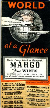
World At A Glance. The Personal Map
Published by American Map Company, New York, 1940
Seller: Antipodean Books, Maps & Prints, ABAA, Garrison, NY, U.S.A.
Association Member: ABAA ANZAAB ESA ILAB
Seller rating 3 out of 5 stars
Ephemera. Folding color map of the world with tabs across the bottom, each with on a different topic, so that one can choose a tab and open the map to the desired region. Including: Near East, Europe, North America, Far East, United States (eastern portion), United States (western portion), Statistical Data, East Indies (Western Australia), South Pacific (Eastern Australia), Central and South America, So. Africa, and India. Large advertisement for "Margo Fine Wines" on Philadelphia on the front wrapper. Heavy card stock with title in red on black at front cover, and with a table of Air Line Distances between Important Cities on the rear cover. Folds into 3x6.35". With the original envelope. Folds out to 34.75 x 6.25". Color printed both sides. Printed at base of index: "Boundaries. .those recognized at the start of WW2 September 1939", very good condition.
-

Johnson's Australia.
Published by Johnson and Ward. (Circa1865)., 1865
Seller: Asia Bookroom ANZAAB/ILAB, Canberra, ACT, Australia
Association Member: ANZAAB ILAB
Seller rating 5 out of 5 stars
Hand coloured map, 32.3 x 39.7 x cms (including the decorative border); 35.6 x 45.8 cms (sheet), key to major centres, unrelated text on verso, sheet age toned, in very good condition. Detailed map from the leading mid 19th Century American firm of Johnson and Ward. Although Tasmania was known as such from 1856, the map refers to "Van Diemen Land".
-

Australasia
Language: English
Publication Date: 1865
Seller: Anah Dunsheath RareBooks ABA ANZAAB ILAB, Auckland, NZ, New Zealand
Association Member: ABA ANZAAB ILAB
Seller rating 5 out of 5 stars
Map
No Binding. Condition: Very Good. Linen-backed map of Australia, New Zealand, Papua New Guinea and western Pacific islands. The Australia map particularly noteworthy for showing the tracks of Burke & Wills, Howitt, Landsborough, Walker, Stuart, McInlay, and Gregory in their explorations of 1861 and 1862 from Victoria, and South and West Australia. The map shows details of capital and other cities, coastal details, and shipping routes. New Zealand islands still named as New Ulster, and New Munster. 31 x 40 cm A rare map with particular interest because of the depicted exploring routes.
-

???????????????? Hyo?jun Daito?a bunzu daito?a bunzu: ?sutorariyahen. Standard Maps of Greater East Asia: Complete Map of Australia.
Published by To?seisha. Showa 18 [1943], Tokyo., 1943
Seller: Asia Bookroom ANZAAB/ILAB, Canberra, ACT, Australia
Association Member: ANZAAB ILAB
Seller rating 5 out of 5 stars
Folding colour map of Australia, 54.2 x 76.4cm. Some foxing particularly along folds and upper right margins a few repaired tears and small holes at folds.With original sleeve. The 15th map in the Standard Maps of Greater East Asia series (of 20 maps). Shows the natural resources such as sheep, gold, pearl, diary regions, opals etc. Tasmania appears as an inset in the bottom right corner. Text in Japanese.
-

J.M. Gilmore's Reise in Central Australien, Jan-Okt. 1871, und Ubersicht des Standpunktes der Geographischen Kenntniss jener Gebiete in 1872. Von A. Petermann
Published by Justus Perthes, Gotha, 1872
Seller: Michael Treloar Booksellers ANZAAB/ILAB, Adelaide, SA, Australia
Association Member: ANZAAB ILAB
Seller rating 5 out of 5 stars
Map
Gotha, Justus Perthes, 1872. A three-colour map (printed surface 246 � 424 mm), mounted on plain paper, with the two original vertical folds barely visible; minimal light foxing; in excellent condition. 'Petermann's Geographische Mittheilungen. Jahrgang 1872, Tafel 22' is printed in the top margin outside the printed border. 'Petermann's Geographische Mittheilungen' (Petermann's Geographical Communications), founded by August Heinrich Petermann in 1855, ceased publication only as recently as 2004. It was 'the oldest German-language journal for geography, in which all major geographical discoveries of the 19th and 20th centuries were published' (Wikipedia). About J.M. Gilmore we have unearthed nothing, and when even such an indefatigable bibliographer as Ian McLaren doesn't record him, you're definitely made a discovery. The map is much more informative. Gilmore made two trips in the Channel Country in south-west Queensland, one in January to March 1871, the other in September-October 1871. The routes are marked in red on the map.
-
Australia. Prepared by Authority of the Honourable the Minister of State for the Interior. Scale 1:253,440 .
Published by 'Prepared by the National Mapping Section, Department of the Interior . Reproduced by Royal Australian Survey Corps', [Canberra], 1951
Seller: Michael Treloar Booksellers ANZAAB/ILAB, Adelaide, SA, Australia
Association Member: ANZAAB ILAB
Seller rating 5 out of 5 stars
Map
Condition: Very Good. [Canberra], 'Prepared by the National Mapping Section, Department of the Interior . Reproduced by Royal Australian Survey Corps', 1951. One map on four sheets, printed surface of each sheet 703 � 955 mm (when joined together, the sheets form a map measuring around 5' � 7' in imperial terms); the sheets are numbered 1-4 (left to right, top then bottom), with the publisher's reference 'AHQ / AO-12 / 0221' printed in the left-hand bottom margin. Four single sheets, as issued; minimal cockling and a few trifling blemishes to some unprinted margins; an excellent set. The states are printed en bloc in different colours; Tasmania appears on the third sheet as an inset (239 � 239 mm). This very large and detailed map shows 'homesteads, minor settlements, Aboriginal reserves, stock routes, highways, principal and other roads, railways, principal civil aerodromes' (Trove), with relief shown by spot heights. We have recently unearthed a small quantity of these maps. Purchasers of the full set may avail themselves of a special offer on a first-come first-served basis: additional copies of the fourth sheet (the south-eastern portion) may be had for $100 each. [4 items].
-
Indiae Orientalis Nova Descriptio.
Publication Date: 1630
Seller: Geographicus Rare Antique Maps, Brooklyn, NY, U.S.A.
Association Member: ABAA ESA ILAB
Seller rating 4 out of 5 stars

Map
Soft cover. Excellent. Gently toned; one tiny wormhole not impacting printed image. Else fine with rich original color. Size 15.5 x 19.75 Inches. This is a gorgeous, original color example of Jan Jansson's 1630 map of the East Indies - the first printed map to present Willem Janszoon's 1606 contact with Australia. It also represents a milestone in the mapping of the Philippines, containing a markedly more precise depiction of the archipelago than any prior printed map. A Closer Look The map reaches from the Andaman and Nicobar Islands to the Marianas ( Insulae de Ladrones ) and from southern China south beyond Java and Timor, thus embracing modern-day Indonesia, the Philippines, Malaysia, Thailand, Laos, and Vietnam, as well as providing a glimpse of the first documented European contact with Australia at York Peninsula. The map is a classic of Dutch decorative cartography, sporting ships, a sea monster, fine compass roses, and elegant cartouches. The scale cartouche is flanked by a merman and a mermaid, and the title cartouche features indigenous warriors. First Dutch Glimpses of Australia The southeastern quarter of the map is rich in new exploration. An elongated north coastline appears for New Guinea: this, and the islands north of it, derive from the ill-fated voyage of Le Maire and Schouten, as transmitted by Joris Spilbergen (1568 - 1620). To the south, the islands spanning from Java Maior and Bali eastwards appear in greater detail than on any earlier printed work. Lombok and the Lesser Sunda Islands have only their north coasts charted, suggesting reports from an unknown voyage touching those coastlines. Following these islands eastwards, the chain turns upwards to the southern coastline of an island not appearing on earlier printed works at all: Duyfkens Eylant , whose blank northern coasts face the blank southern coasts of t' Landt vande Papuos , or New Guinea. Even further east appear more incomplete coastlines, with the placenames Modder Eylandt and Tyuri . These latter details are derived from Willem Janszoon's 1606 voyage on the pinnace Duyfken . Janszoon's Duyfkens Eylant proved to be southwestern New Guinea, and he supposed that the coastline of Modder Eylandt might connect. That discovery would prove momentous: this was not part of New Guinea but was instead the western coast of Australia's Cape York Peninsula. While Janszoon's report spurred further exploration, it was not committed to any prior printed map. His 1606 discoveries were not publicized at the time, nor were they coherently synthesized with other East India discoveries. His journal and chart were lost, although reports of these discoveries would spread, being mentioned in Dutch documents as early as 1618. The earliest appearance of this cartography is on the 1622 Hessel Gerritsz manuscript map Mar del Sur , produced when Gerritsz was the Official Hydrographer to the Dutch East India Company (VOC). Scrutiny of that work reveals it to be the clear precursor to Jansson's map from Borneo eastwards. A Landmark in the Mapping of the Philippines Jansson's map also benefits from Gerritsz in its sophisticated depiction of the Philippine Archipelago, appearing in print here for the first time. In the first part of the 17th century, European printed maps of the Philippines were overwhelmingly derived from Jan van Linschoten. Even the 1619 De Bry map - produced to accompany Joris van Spilbergen's account of his circumnavigation - did not materially improve Philippine geography. This was likely the result of protections the VOC maintained until 1619, strictly controlling the dissemination of new information relating to their sphere of operation. In that context, the depiction of the Philippines found on the present map appears out of nowhere. Gerritsz's geography does, however, reintroduce an error that had appeared fleetingly on some earlier maps: the phantom island of St. Juan, on the northeast coast of Mindanao. It appeared first on Ortelius' 1570 map of Asia, only to.
-

Map of Australia Compiled from the Nautical Surveys, Made by Order of The Admiralty, And other Authentic Documents, By James Wyld Geographer to the Queen.
Publication Date: 1858
Seller: Geographicus Rare Antique Maps, Brooklyn, NY, U.S.A.
Association Member: ABAA ESA ILAB
Seller rating 4 out of 5 stars
Map
Hardcover. Good. Dissected and mounted on original linen in 24 panels. Even overall toning. Exhibits light soiling. Brown cellophane tape residue evident along top border. Accompanied by red leather case. Size 23 x 34.25 Inches. This is a c. 1858 James Wyld map of Australia during the Australian Gold Rush. Depicting the entire continent as well as Tasmania, Wyld illustrates Australia as is being transformed by aggressive colonization and mineral exploitation. A Closer Look Counties are most prevalent in New South Wales and Victoria, while a handful had been established in South Australia, Queensland, and modern-day Western Australia. Cities and towns in these counties are labeled, including Sydney, Brisbane, Melbourne, and Perth. Gold veins are indicated by very thin lines, many of which resemble small rivers. Very little inland detail is present, although some lakes and rivers are noted. Australian Gold Rush of 1851 Gold was known to be present in Australia prior to 1851, but the intentional suppression of this information by the colonial government of New South Wales prevented all-out gold rushes. When gold was discovered at Sutter's Mill, California, in 1848, causing the California Gold Rush, countless Australians migrated in search of their fortunes. Desirous of maintaining their dwindling work force, the colonial governors rethought their position, and sought approval from the Colonial Office in England to allow the exploitation of the mineral resources and also offered rewards for the finding of payable gold. This led to the first major Australian gold rush when prospector Edward Hargraves discovered gold at Ophir, near Orange. A series of subsequent discoveries followed, transforming the Australian economy and leading to a rush of new immigration. In Victoria, for example, Melbourne, which had a population of around 29,000 in 1851, grew to over 500,000 by 1861 and then to 700,000 by 1869. This population boom forced the British government to allow the Port Philip District to secede from New South Wales and form the Colony of Victoria. Gold production in Victoria exceeded all other gold producing regions in the world, excepting California, with its highest annual yield reaching 3,053,744 troy ounces in 1856. It is estimated that between 1851 and 1896 a total of 61,034,682 ounces of gold were extracted from mines in Victoria. Publication History of Wyld's Map of Australia Wyld's Map of Australia is generally underappreciated. Wyld published meticulously updated editions from 1833 until at least 1869, with his son publishing subsequent editions until the 1890s. This attention to detail and regular updates provide an map-to-map historical record Australia's development. Counties proliferate from a small group clustered around Sydney to encompassing the whole of Victoria by the mid-1860s. Here, as stated above, counties spread all along the coasts of New South Wales and Victoria with small enclaves in South Australia and Queensland. At least 22 editions of Wyld's Australia are catalogued by the National Library of Australia, with 20 viewable online, while one of the other 2 are available via the Biblioth�que nationale de France and the State Library of New South Wales. Dating This Edition Despite a long publication history, Wyld dated the editions of this map only from 1833 to about 1844, with the next dated edition appearing in 1890. Editions between 1844 and 1890 are universally undated, leading to countless cataloging errors. After comparing editions digitized by the National Library of Australia, the State Library of New South Wales, and the Biblioth�que nationale de France, we have created a rough timeline for this map. The present map identifies MacDonnell county, which was not founded until 1857, thus suggesting a c. 1858 publication. Publication History and Census This map was created by James Wyld and was published c. 1858 in London. While multiple editions of this map do appear in various catalogs, we have not been able to.
-

Carte de La Nle. Galles Meridle. Ou de la Cote Orientale de la Nle. Hollande Decouverte et visitee par le Lieutenant J. Cook, Commandant de L'Endeavour, vaisseau de sa Majeste en 1770.
Publication Date: 1774
Seller: Geographicus Rare Antique Maps, Brooklyn, NY, U.S.A.
Association Member: ABAA ESA ILAB
Seller rating 4 out of 5 stars
Map First Edition
Soft cover. 1st Edition. Very good. Margin reinstated at insertion point not affecting image, else excellent. Size 14 x 30.5 Inches. This is the 1774 first French edition of James Cook's seminal first map of New South Wales, Australia. The map is a product of Cook's search for the often speculated upon southern continent or 'Terra Australis,' which scholars from the 16th century on believed, based upon ancient Greek texts, must exist at the base of the world. This map is significant for Australia collectors as the first definitive mapping of the coasts of New South Wales. A Closer Look Oriented to the West, the map extends from Cape York, Prince of Wales Island, and the Endeavour Straits to Point Hicks (Victoria). The map notes both Botany Bay and Port Jackson. Cook's Voyage After observing the Transit of Venus on June 3, 1769, Cook sailed westward, planning to return to England via the Cape of Good Hope, as he believed the Endeavour would not survive a second trip around Cape Horn. Instead, he sailed west, where he hoped to discover Terra Australis. He sailed around New Zealand and headed for Tasmania, intending to follow up on Abel Tasman's work, when gales forced him northward. On April 19, 1770, his second, Zachary Hicks, sighted land, what Cook immediately named Point Hicks. While Cook was most certainly aware he had not discovered 'Terra Australis,' he did spend several months, from April 19 to August 22, 1770, mapping the long sought east coast of New Holland (Australia), what he came to call New South Wales. He proceeded northwards, navigating the coast with great care, naming notable locations along the way. Unmapped Coast It is of note that the coast between Cape Flattery and Weymouth remains unmapped. This area is so full of small islands and dangerous reefs that Cook aptly named it 'The Labyrinth.' Just as he entered this area, near Cape Tribulation, the Endeavour struck a reef. On our map, there is a note reading, 'On this ledge the ship laid 23 hours.' Rather than risk his ship further Cook sailed the Endeavour further out to sea, around the perilous reefs, landing at Cape York to officially name New South Wales and claim the land for England, I now once more hoisted English Coulers and in the Name of His Majesty King George the Third took possession of the whole Eastern Coast from the above Latitude [38] down to this place by the name of New South Wales, together with all the Bays, Harbors, Rivers, and Island s situate upon the said coast. (Cook, J., Journal, August 22, 1770) Until this time, it was assumed that Australia, or New Holland as it was known, was a barren wasteland, as the Dutch navigators had explored only a small part of the arid western coast. On the other hand, Cook sailed up the fertile east coast and was impressed by what he saw. It was Cook who recommended settlement and persuaded Joseph Banks to argue for using the remote continent as a penal colony. Cook's nomenclature largely remains in use today. Publication History and Census This map was engraved by Robert B�nard for the 1774 French edition of James Hawkesworth's 1773 account of Cook's voyages. It follows the 1772-1773 English edition engraved by William Whitchurch and published in 1773. There are known editions in English, French, and German. While well represented institutionally, this map is rare to the market. References: OCLC 977416224. Australia in Maps, (National Library of Australia), page 51. National Library of Australia, MAP T 325. Tooley, R.V. (Australia) 325, pl.20. Tooley, R.V., Bricker, C.; Crone, Gerald Roe, Landmarks of Mapmaking; an Illustrated Survey of Maps and Mapmakers, p.263. Clancy, R. 6.33. Perry, T. M., and Prescott, D. F., A Guide to Maps of Australia in Books Published 1780-1830, 1773.02.


![Seller image for Philips' Series of Travelling Maps. South Australia [cover title on the cloth case of a linen-backed folding map] for sale by Michael Treloar Booksellers ANZAAB/ILAB](https://pictures.abebooks.com/inventory/md/md14916534518.jpg)