

Order Total (1 Item Items):
Shipping Destination:

Map Crimea (5 results)
Skip to main search results
Search filters
Product Type
- All Product Types
- Books (1)
- Magazines & Periodicals (No further results match this refinement)
- Comics (No further results match this refinement)
- Sheet Music (No further results match this refinement)
- Art, Prints & Posters (No further results match this refinement)
- Photographs (No further results match this refinement)
- Maps (4)
- Manuscripts & Paper Collectibles (No further results match this refinement)
Condition Learn more
- New (No further results match this refinement)
- As New, Fine or Near Fine (No further results match this refinement)
- Very Good or Good (1)
- Fair or Poor (No further results match this refinement)
- As Described (4)
Binding
- All Bindings
- Hardcover (No further results match this refinement)
- Softcover (1)
Collectible Attributes
- First Edition (No further results match this refinement)
- Signed (No further results match this refinement)
- Dust Jacket (No further results match this refinement)
- Seller-Supplied Images (5)
- Not Print on Demand (5)
Language (1)
Price
- Any Price
- Under US$ 25 (No further results match this refinement)
- US$ 25 to US$ 50 (No further results match this refinement)
- Over US$ 50
Free Shipping
- Free Shipping to U.S.A. (No further results match this refinement)
Seller Location
Seller Rating
-
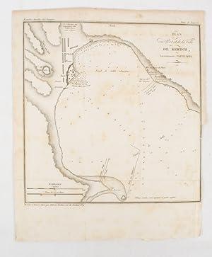
Plan du Port at de la Ville de Kertch, Anciennement Panticapée
Published by (Librairie de Gide). (1839)., (Paris)., 1839
Seller: Asia Bookroom ANZAAB/ILAB, Canberra, ACT, Australia
Association Member: ANZAAB ILAB
Seller rating 5 out of 5 stars

Engraved map, 21.1 x 20.8 cm, 27 x 22 cm (sheet), original folds trimmed to the inner margin with slight loss to the border only, map spotted, but otherwise in sound condition. Map of the Port of Kerch in Crimea prepared for the 1839 edition of the French Journal "Nouvelles Annales des Voyages.", the editors for this edition (amongst others) the translator and geographer Jean-Baptiste Benoît Eyriès and Alexander von Humboldt, founding members of the world's first geographical society, the Société de Géographie.
-
HER MOST GRACIOUS MAJESTY QUEEN VICTORIA AND THE ALLIED ARMIES OF FRANCE AND ENGLAND MILITARY AND TOPOGRAPHICAL MAP OF THE KRIMA PENINSULA.
Published by Engraved and Printed at the Military Topographical Depot attached to the Etat-Major or Staff of His Imperial Majesty ar, 1817
Seller: HALEWOOD AND SONS ABA ILAB Est. 1867., PRESTON, United Kingdom
Association Member: ABA ILAB PBFA
Seller rating 2 out of 5 stars

Map
US$ 2,078.78
US$ 16.28 shipping
Ships from United Kingdom to U.S.A.Quantity: 1 available
Add to basketStunning LARGE 3 part linen-mounted folding colour Map;- each part extending to 51" x 31" and with sheets of letter-press laid on to outer panels. In remnants of heavily worn original leather slip-case (with 'The Yorkshire Brigade Museum Reference Library' bookplate to verso.) A Very Good example of this Rare Map.
-

Philips' New Map of the Crimea with Map of Europe and View of Sevastopol.
Publication Date: 1854
Seller: Geographicus Rare Antique Maps, Brooklyn, NY, U.S.A.
Association Member: ABAA ESA ILAB
Seller rating 4 out of 5 stars

Map
Very good. Verso repairs to fold separations. Exhibits old verso repairs at a few fold intersections. Exhibits slight loss at a few fold intersections. Size 20.25 x 27 Inches. This is a striking 1854 George Philip map of the Crimean Peninsula (Crimea) during the Crimean War. Coverage extends from the Dnieper River to the Black Sea, and from Tendra Bay to the Sea of Azov. Text near Kalamita Bay follows the action of the Crimean War. A notation marks where the Allies landed on September 14, and another indicates the site of the Battle of the Alma and Allied and Russian positions. Sevastopol, the Allied objective, is identified at the bottom of Kalamita Bay. A view of Sevastopol is situated along the bottom border. Within the view, three forts, the cemetery, and a lighthouse are named. An inset map of Europe in the bottom right situates Crimea in relation to continental Europe. The Crimean War The Crimean War, with an alliance of the Ottoman Empire, Britain, France, and Sardinia on one side of the conflict and the Russian Empire on the other, lasted from October 1853 until February 1856. The root cause of the war has never been fully understood, but the stated impetus for hostilities was the rights of Christians in the Holy Land, with the Catholics being supported by the French and the Greek Orthodox Church gaining the support of the Russians. Other factors also included the gradual decline of the Ottoman Empire and British and French concerns about Russian gains in the region at the cost of the Ottomans. Hostilities erupted in July 1853 when Russia invaded two Ottoman suzerainties known collectively as the Danubian Principalities: Wallachia and Moldavia. The Ottomans immediately responded and fought a defensive campaign that eventually halted the Russian advance at Silistra, which the Russians besieged. Alarmed by the possibility of an Ottoman collapse, the British and French jumped to their aid, sending troops and supplies to Gallipoli. They did not arrive at Silistra until after the Russians had withdrawn. At this point, public opinion at home, where discontent aroused by the wasted effort and expense of sending armies to the Balkans, exerted an influence on the alliance. This outcry led to the planning and execution of an invasion of the Crimean Peninsula and a siege of the Russian naval port of Sevastopol, their primary naval base in the Black Sea. The siege lasted eleven months. Russia finally sued for peace in March 1856. In the Treaty of Paris that ended the war Russia lost its Black Sea ports, Wallachia and Moldavia gained a modicum of independence, and Christians in the Holy Land were given a degree of equality. Publication History and Census This map was created and published by George Philip in 1854. We note a single example cataloged in OCLC which is part of the collection at the National Library of Scotland. References: OCLC 316360022.
-

Carte de l'Asie Mineure ou de la Natolie et du Pont Euxin, tiree des Voyages et des Observations des Anciens et Modernes. Asiae Minoris Veteris et Novae, itemque Ponti Euxini et Paludis Maeotidis Mappa val Tabula.
Publication Date: 1743
Seller: Geographicus Rare Antique Maps, Brooklyn, NY, U.S.A.
Association Member: ABAA ESA ILAB
Seller rating 4 out of 5 stars
Map
Very good. Minor wear along original centerfold. Minor creasing. Original platemark visible. Minor foxing. Manuscript notes in pencil along left margin, can be easily erased. Size 20 x 23.5 Inches. This is an attractive 1743 map of Asia Minor by the Homann Heirs. The map depicts Turkey and the regions surrounding the Black Sea including parts of modern day Crimea, Romania, Russia, Ukraine, Georgia and Greece. Centered on the Black Sea, extends south to Cyprus and Crete and north to include the Sea of Azov. Notes the ancient Kingdoms of Asia Minor, many of which were Greek colonies or heavily influenced by Greek culture. These include Mysia, Lycia, Pisidia, Cilicia, Phrygia, Pontus, Lydia, Caria, Thynia, Phrygia Minor, Cappadocia, Armenia Minor, etc. This region saw the development of currency, the conquest of Troy as well as the construction of three of the Ancient World's Seven Wonders. Highly detailed, it notes important cities rivers, mountains and a host of other topographical features. A large decorative cartouche in the upper left quadrant includes a description with illustrations of a temple, two warriors and other medieval and classical accents. This map was drawn by Johann Matthias Haas and issued by Homann Heirs in 1743. References: OCLC: 842521113.
-

Tartaria d'Europa o vero Piccola Tartaria divisa da Giacomo Cantelli da Vignola ne Tartari Nogai e del Crim, o di Precop Soggetti al proprio Kam ne Tartari di Budziack, d'Oczackow, e di Dobruss, soggetti al Turco, ne Tartari Circassi, e di Mordua Soggetti al Gran Duca di Moscovia e nelle Due Uckraine.
Publication Date: 1684
Seller: Geographicus Rare Antique Maps, Brooklyn, NY, U.S.A.
Association Member: ABAA ESA ILAB
Seller rating 4 out of 5 stars
Map
Very good. Marginal mend at bottom centerfold not impacting printed image. Minor stain at right in 'Astrachan.' Else excellent with a bold strike and original outline color. Size 17.5 x 22 Inches. This is a 1684 Cantelli da Vignola map of the Caucasus, the lands of the Circassian and Crimean Tartars, Georgia, and Ukraine. The region - peopled by an array of Tatar and Cossack tribes - was largely under the domination of the Crimean Khanate and the Nogai Horde, but represented a borderland contested by the Grand Duchy of Muscovy and the Turkish Empire. Ukraine The region surrounding the lower Dnieper River is here identified as Ukraina ó Paese de Cosacchi di Zaporowa , that is to say the country of the Zaporozhian Cossacks. As recently as the end of the 16yth century, these were considered subjects of the Polish-Lithuanian Commonwealth, at least to the extent that they chose to raid the Ottoman Empire, as Tatars subject to the Ottomans raided the Commonwealth. Indeed, in 1615 and 1625 the Cossacks were burning Constantinople's suburbs, forcing the Sultan to flee. Following the Polish-Ottoman War of the 1670s, the famed intransigence of the Zaporozhian Cossacks were immortalized in the justifiably long-lived, hilarious literary forgery of the Correspondence between the Ottoman Sultan and the Cossacks . The Russian Frontier The map captures the region during the dual regency of Peter (the Great) and his elder brother Ivan, with power in the hands of their half-sister Sophia Alekseyevna (1657 - 1704). She wrested the regency from Peter's mother in a temporarily successful bid to prevent Peter from bypassing his brother and inheriting the throne. Between 1682 and 1689, Sophia ruled as an autocrat behind her puppet brothers. Despite her canny political sense, and the support of the Streltsy, her reign was marked and weakened by unsuccessful efforts to defeat the Crimean Khanate, who raided southern Russia with impunity. It was not until the 1690s that Peter, as Tsar, captured the fortress of Azov from the Crimean Khan Tatars and the Ottoman Sultan, thus taking control of the Don River. On Cantelli's map, Azov is marked with the symbol of the crescent, signifying its allegiance to the Turkish Empire. A Much-Updated Work Cantelli is notable for his efforts to reconcile conflicting modern and classical information. According to Chikobava, (2006) the place names employed in the vicinity of Georgia, particularly the Principalities of Odishi and Guria, indicate that Cantelli's map reflected the conquest of Guria by Georgian leader Levan II Dadiani (1611 - 1657). Thus, despite many map features being drawn from antique sources, Cantelli also updated his work with recent data. This would have been significant, as the region's primary characteristic is one of turmoil: the allegiances, territorial holdings, and borders were in constant flux. Sevastopol? The place name Sevastopol appears in two different forms on this map, and in two separate locations. Sixteenth and seventeenth century maps show a Black Sea port of Savatopolis in the vicinity of modern-day Sukhumi (also named Dioscurias by the Greeks; Ortelius' Pontus Euxinus uses both Savatopolis and the Greek term; Cantelli's map places Savatopoli ). Both Ortelius and Cantelli apply the name Sebastopoli to the city of Faso at the mouth of the Rioni river. Modern day Sevastopol did not exist at the time this map was produced - it was not founded for another century, following Russia's annexation of the Crimean Khanate. In 1784, Catherine the Great ordered the construction of a fortress there, and named it Sevastopol to emphasize the Russian Empire's role as the Third Rome, and successor to the Byzantine Empire. The Engraving Cantelli's maps, notably their cartouches, were some of the most attractively engraved of the later 17th century. The present map is no exception. A superbly executed copperplate engraving, it is the work of engraver Vincenzo Marietti, whose imprint appears in the lower.


