Order Total (1 Item Items):
Shipping Destination:

Map Cruchley (17 results)
Skip to main search results
Search filters
Product Type
- All Product Types
- Books (3)
- Magazines & Periodicals (No further results match this refinement)
- Comics (No further results match this refinement)
- Sheet Music (No further results match this refinement)
- Art, Prints & Posters (No further results match this refinement)
- Photographs (No further results match this refinement)
- Maps (14)
- Manuscripts & Paper Collectibles (No further results match this refinement)
Condition Learn more
- New (No further results match this refinement)
- As New, Fine or Near Fine (No further results match this refinement)
- Very Good or Good (2)
- Fair or Poor (No further results match this refinement)
- As Described (15)
Binding
Collectible Attributes
- First Edition (1)
- Signed (1)
- Dust Jacket (No further results match this refinement)
- Seller-Supplied Images (16)
- Not Print on Demand (17)
Language (2)
Price
- Any Price
- Under US$ 25 (No further results match this refinement)
- US$ 25 to US$ 50 (No further results match this refinement)
- Over US$ 50
Free Shipping
- Free Shipping to U.S.A. (No further results match this refinement)
Seller Location
Seller Rating
-
Circa 1868 CRUCHLEY'S RAILWAY AND TELEGRAPHIC COUNTY MAP OF SHROPSHIRE
Language: English
Published by G. F. Cruchley, Map Publisher and Globe Manufacturer, London, 1868
Seller: Andrew Cox PBFA, Shropshire, United Kingdom
Association Member: PBFA
Seller rating 5 out of 5 stars

First Edition
US$ 75.95
US$ 26.14 shipping
Ships from United Kingdom to U.S.A.Quantity: 1 available
Add to basketSoft cover. Condition: Good. 1st Edition. Undated, but circa 1868, this is a folding hand coloured railway map of Shropshire from G. F. Cruchley, Map Publisher and Globe Manufacturer, bound in the original printed paper covers, the folding map fully opened measures 56cm by 50cm approx., the covers have edge wear chipping and creasing wear. The map has splits along fold lines, a couple of short tears with no loss, some creasing wear and marking else in good acceptable condition. this is a lighter item, shipping costs will be reduced at checkout where possible.
-

From the Ordnance Survey.
Published by G.F.Cruchley, London
Seller: Hereward Books, Ely, CAMBR, United Kingdom
Association Member: PBFA
Seller rating 4 out of 5 stars

US$ 303.80
US$ 46.92 shipping
Ships from United Kingdom to U.S.A.Quantity: 1 available
Add to basketHardcover. Condition: Very Good. 137 x 110 cm, Full wash hand colour with ornate Decorative border. Segmented & pasted on linen. Taken from Cruchleys Improved Map of ENGLAND AND WALES Engraved on Sixty-Five sheets and ?PLANNED ON A SCALE OF TWO MILES TO AN INCH? Sheets 32-33-26-27 Covering the counties of Leicestershire, Huntingdonshire, Cambridgeshire Buckinghamshire, Hertfordshire, Oxfordshire, Essex. Extent Peterborough to Edgeware and Banbury to Halstead. Showing railways and proposed railways, stations, roads boundaries, woodlands Gentlemen?s Seats,etc. The coloring bright and fresh. Folding into brown cloth wallet, blind stamped boards with gilt title to front; REDUCED ORDNANCE SURVEY. Pasted labels inside showing index and key maps. Cloth cracked on joints but case remains tight some age fading to the cloth.
-
Cruchley's Improved Geographical Companion Throughout England & Wales Including Part of Scotland.
Published by London: G. F. Cruchley Map-Seller, 1830
Seller: Forest Books, ABA-ILAB, Grantham, LINCS, United Kingdom
Association Member: ABA ILAB PBFA
Seller rating 4 out of 5 stars
Map
US$ 338.32
US$ 33.52 shipping
Ships from United Kingdom to U.S.A.Quantity: 1 available
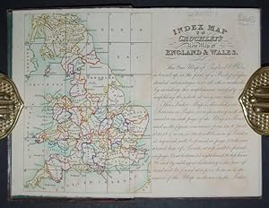
Add to basket8vo, [2], 36pp., detailed general map divided into 36 sections corresponding with the index map at the beginning, neatly hand-coloured, cont. cloth, orig. printed label on upper cover. Includes a table of reference giving a list of cities with population figures for 1801, 1811 and 1821 with the distances from London, and index map. Inset of the Scilly Isles. "This New Map of England & Wales, as bound up in the form of a Book, possesses decided advantages over all other methods, by avoiding the unpleasant necessity of unfolding the whole at any one time".
-
CRUCHLEY'S IMPROVED GEOGRAPHIC COMPANION THROUGHOUT ENGLAND & WALES Including Part of SCOTLAND
Published by G. F. Cruchley, 349 Oxford Street, London, 1822
Seller: Tavistock Books, ABAA, Reno, NV, U.S.A.
Association Member: ABAA ESA ILAB IOBA
Seller rating 5 out of 5 stars
Condition: A VG+ map in a similar case. Second Edition [stated]. A dissected, very detailed 25-panel, hand-colored in outline, linen-backed map. Title set in border top-right. Scale: 1" = 10.91 miles. Unfolded: 38-5/8" x 26-1/4"; Folded in Portfolio: 7-3/4" x 5-1/4" An early publication from this London carographer- no copy recorded on OCLC, with the British Library, per their on-line listings, holding only a later 1827 edition. Housed in the publisher's original green paste-paper slipcase, with printed paper title label to one side ["CRUCHLEY'S NEW MAP Of ENGLAND And WALES ."]. Matching green paper backing to 2 outer panels of folded map.
-

Europe.
Publication Date: 1850
Seller: Geographicus Rare Antique Maps, Brooklyn, NY, U.S.A.
Association Member: ABAA ESA ILAB
Seller rating 4 out of 5 stars
Map
Very good. Minor wear and some toning over original centerfold. Blank on verso. Spotting near the Lofoden Isles. Size 15 x 18 Inches. This is an attractive 1850 map of Europe issued by George Frederick Cruchley. It covers the entirety of the continent, including Iceland, from the Arctic Ocean to the Mediterranean Sea and from the Antarctic Ocean eastward as far as the Ural Mountain range. It shows the Austrian Empire at its height and the many states of the German Confederacy. This map was created at a time in history that witnessed the unification of Italy and saw the British empire rise to its peak. It was also a time of decline for the Ottoman Empire. The map is color coded according to countries and territories with various towns, cities, rivers, mountains and several other topographical details identified. Elevation is rendered by hachures. Cruchley's General Atlas was unique for its period, employing a vivid color scheme extending even to the oceans, distinctive typography, and various uncommon decorative elements including a peacock feather crown and an imprint medallion, both of which break the printed border. Though many of the maps in this atlas are copyrighted in 1841 or 1842, the atlas was first published in 1843 from the Cruchley office at 81 Fleet Street, London, and proving popular went through numerous reissues well into the 1850s.
-

Austria.
Publication Date: 1850
Seller: Geographicus Rare Antique Maps, Brooklyn, NY, U.S.A.
Association Member: ABAA ESA ILAB
Seller rating 4 out of 5 stars
Map
Very good. Minor wear and some toning over original centerfold. Blank on verso. Size 15 x 18 Inches. This is a lovely example of the 1850 George Frederick Cruchley map of Austria. It covers the territories claimed by the once vast Austro-Hungarian Empire, including in whole or part the modern day nations of Austria, Hungary, Germany, Italy, Albania, Croatia, Romania, and the Czech Republic. The Austrian empire, founded in 1804 by the last Holy Roman emperor, Francis II, lasted only till 1866. It was transformed into the Austro-Hungarian Empire after Austria was defeated in the Austro-Prussian War of 1866. Cruchley's General Atlas was unique for its period, employing a vivid color scheme extending even to the oceans, distinctive typography, and various uncommon decorative elements including a peacock feather crown and an imprint medallion, both of which break the printed border. Though many of the maps in this atlas are copyrighted in 1841, the atlas was first published in 1843 from the Cruchley office at 81 Fleet Street, London, and proving popular went through numerous reissues well into the 1850s.
-

England.
Publication Date: 1850
Seller: Geographicus Rare Antique Maps, Brooklyn, NY, U.S.A.
Association Member: ABAA ESA ILAB
Seller rating 4 out of 5 stars
Map
Very good. Minor wear and some toning over original centerfold. Blank on verso. Size 18 x 15 Inches. This is a lovely example of George Frederick Cruchley's 1850 map of England. It covers both England and Wales from Northumberland to Cornwall and from the St. George's Channel east as far as the Strait of Dover. The Isle of Man is also included. During this time, both England and Wales were in the midst of the Industrial Revolution, wherein much of the rural agricultural population was relocating to urban centers. This map is color coded according to regions and provinces and identified several important towns, cities, rivers, mountains and an assortment of other topographical features. Relief is shown by hachures. Cruchley's General Atlas was unique for its period, employing a vivid color scheme extending even to the oceans, distinctive typography, and various uncommon decorative elements including a peacock feather crown and an imprint medallion, both of which break the printed border. Though many of the maps in this atlas are copyrighted in 1841, the atlas was first published in 1843 from the Cruchley office at 81 Fleet Street, London, and proving popular went through numerous reissues well into the 1850s.
-

France.
Publication Date: 1850
Seller: Geographicus Rare Antique Maps, Brooklyn, NY, U.S.A.
Association Member: ABAA ESA ILAB
Seller rating 4 out of 5 stars
Map
Very good. Minor wear and some toning over original centerfold. Blank on verso. Size 15 x 18 Inches. This is a fine example of George Frederick Cruchley's 1850 map of France. It covers all of France subdivided according to its various departments. An inset in the lower right quadrant details Corsica. The map is color coded according the departments with elevation shown by hachures. Several towns, rivers, cities, mountains, along with a host of other topographical features are also identified. The French Department system was established on March 4th, 1790 by theNational Constituent Assemblyto replace the provinces with what the Assembly deemed a more rational structure. They were designed to deliberately break up France's historical regions in an attempt to erase cultural differences and build a more homogeneous nation. Initially there were 83 departments but by 1800 that number increased to roughly 130. Many of the departments that were created in 1790 remain the administrative districts to this day. Cruchley's General Atlas was unique for its period, employing a vivid color scheme extending even to the oceans, distinctive typography, and various uncommon decorative elements including a peacock feather crown and an imprint medallion, both of which break the printed border. Though many of the maps in this atlas are copyrighted in 1841, the atlas was first published in 1843 from the Cruchley office at 81 Fleet Street, London, and proving popular went through numerous reissues well into the 1850s.
-

Holland and Belgium.
Publication Date: 1850
Seller: Geographicus Rare Antique Maps, Brooklyn, NY, U.S.A.
Association Member: ABAA ESA ILAB
Seller rating 4 out of 5 stars
Map
Very good. Minor wear over original centerfold. Blank on verso. Size 18 x 15 Inches. A beautiful example of by George Frederick Cruchley's 1850 map of Holland (Netherlands) and Belgium. It covers the region from the North Sea to the Duchy of Luxemburg in the South. This map is color coded according the counties and provinces, showing important cities, towns, rivers, lakes, mountains and other important topographical features. Elevation is rendered in hachure. In 1830, the Belgian Revolution led to the secession of Belgium from the United Kingdom of Netherlands and it's subsequently consolidation as the independent Kingdom of Belgium. Though Belgium had successfully attained self-rule, the Netherlands refused to recognize the new country until the 1839 Treaty of London. Cruchley's General Atlas was unique for its period, employing a vivid color scheme extending even to the oceans, distinctive typography, and various uncommon decorative elements including a peacock feather crown and an imprint medallion, both of which break the printed border. Though many of the maps in this atlas are copyrighted in 1841, the atlas was first published in 1843 from the Cruchley office at 81 Fleet Street, London, and proving popular went through numerous reissues well into the 1850s.
-

Russia in Europe.
Publication Date: 1850
Seller: Geographicus Rare Antique Maps, Brooklyn, NY, U.S.A.
Association Member: ABAA ESA ILAB
Seller rating 4 out of 5 stars
Map
Very good. Minor wear over original centerfold. Blank on verso. Size 18 x 15 Inches. This is a lovely 1850 map of Russia by George Frederick Cruchley. It covers the European portions of Russia from the Gulf of Bothnia to the Ural Mountains and from the Arctic south as far as the Black Sea. The modern day nations of Russia, Ukraine, Belarus, Moldova, Poland, Lithuania, Latvia, Estonia and Finland are included. Russia at this time was under the suzerainty of Tzar Alexander the II. Alexander is best known for his liberal reforms including the emancipation Reform of 1861 which liberated Russia's countless serfs and is considered to be the most important event in 19th century Russian history. This map is color coded according the counties and provinces, showing important cities, towns, rivers, lakes, mountains and other important topographical features. Elevation is rendered by hachures. Cruchley's General Atlas was unique for its period, employing a vivid color scheme extending even to the oceans, distinctive typography, and various uncommon decorative elements including a peacock feather crown and an imprint medallion, both of which break the printed border. Though many of the maps in this atlas are copyrighted in 1841, the atlas was first published in 1843 from the Cruchley office at 81 Fleet Street, London, and proving popular went through numerous reissues well into the 1850s.
-

Spain and Portugal.
Publication Date: 1850
Seller: Geographicus Rare Antique Maps, Brooklyn, NY, U.S.A.
Association Member: ABAA ESA ILAB
Seller rating 4 out of 5 stars
Map
Very good. Minor wear and some toning over original centerfold. Blank on verso. Size 15 x 18 Inches. This is a beautiful example of George Frederick Cruchley's 1850 map of Spain and Portugal. It covers all of Spain and Portugal from the Pyrenees to the Strait of Gibraltar and includes the Balearic Islands of Ibiza and Majorca, with Minorca in a small inset. The map is color coded according to regions and territories and notes several cities, towns, rivers, mountains and other topographical features. As this map was printed liberal sentiments within Spain were gaining popularity. This eventually led to the Progressive Biennium, in which the Progressive Party tried to replace the conservative liberalism of the Moderate Party with more radical liberalism. Cruchley's General Atlas was unique for its period, employing a vivid color scheme extending even to the oceans, distinctive typography, and various uncommon decorative elements including a peacock feather crown and an imprint medallion, both of which break the printed border. Though many of the maps in this atlas are copyrighted in 1841, the atlas was first published in 1843 from the Cruchley office at 81 Fleet Street, London, and proving popular went through numerous reissues well into the 1850s.
-

Switzerland.
Publication Date: 1850
Seller: Geographicus Rare Antique Maps, Brooklyn, NY, U.S.A.
Association Member: ABAA ESA ILAB
Seller rating 4 out of 5 stars
Map
Very good. Minor wear and some toning over original centerfold. Blank on verso. Size 15 x 18 Inches. A lovely example of the 1850 George Frederick Cruchley map of Switzerland. It covers the entirety ofSwitzerland divided into its constituent Cantons from Vaud to the Grisons. After the ratification of a federal constitution in 1848, Switzerland underwent a rapid social and economic development. The cantonal currencies were replaced by a single currency (the Swiss Franc) and many of the cantons subsequently established representative governments and instituted freedom of the press and trade. Cruchley's General Atlas was unique for its period, employing a vivid color scheme extending even to the oceans, distinctive typography, and various uncommon decorative elements including a peacock feather crown and an imprint medallion, both of which break the printed border. Though many of the maps in this atlas are copyrighted in 1841, the atlas was first published in 1843 from the Cruchley office at 81 Fleet Street, London, and proving popular went through numerous reissues well into the 1850s.
-

United States with Upper & Lower Canada.
Publication Date: 1850
Seller: Geographicus Rare Antique Maps, Brooklyn, NY, U.S.A.
Association Member: ABAA ESA ILAB
Seller rating 4 out of 5 stars
Map
Very good. Minor wear and some toning over original centerfold. Blank on verso. Size 18 x 15 Inches. An attractive 1850 map of the United States and parts of Canada by George Frederick Cruchley. The map covers the United States east of Texas and the Indian Territory as well as parts of Canada south of the Hudson Bay and west of Nova Scotia. Cruchley divides the states with color coding identifying major cities as well major rivers. Topography is rendered by hachure. The 1850s were a period of both great hope and simmering tensions in the United States. The discovery of gold in California one year earlier initiated and mass trans-continental emigration in the quest for wealth and land. California was admitted as the 31st state in September of this year and the cities of Los Angeles and San Francisco were incorporated. Meanwhile, tensions continued to rise between the slave holding agrarian southern states and the industrialized 'free' northern states. The Compromise of 1850, intended to placate the slave holding states, essentially divided the United States along lines that, by 1861, would degenerate in the American Civil War. Cruchley's General Atlas was unique for its period, employing a vivid color scheme extending even to the oceans, distinctive typography, and various uncommon decorative elements including a peacock feather crown and an imprint medallion, both of which break the printed border. Though many of the maps in this atlas are copyrighted in 1841, the atlas was first published in 1843 from the Cruchley office at 81 Fleet Street, London, and proving popular went through numerous reissues well into the 1850s.
-

Cruchley's New Plan of London.
Publication Date: 1860
Seller: Geographicus Rare Antique Maps, Brooklyn, NY, U.S.A.
Association Member: ABAA ESA ILAB
Seller rating 4 out of 5 stars
Map
Very good. Folds into original binder. Size 18.5 x 25.5 Inches. A first-edition example of George Frederick Cruchley's 1860 pocket map of London, England. The map captures the city at the height of the city-wide 19th-century urbanization that coincided with the Industrial Revolution. A Closer Look Centered on Blackfriars Bridge, the map covers from Regent's Park to Chelsea Hospital and from Hyde Park to Southwark Park. Streets, bridges, wharves, docks, parks, the imprints of important buildings, and railway stations are identified throughout. The map gives particular attention to the railroads, highlighted in red, that were being developed throughout London at the time. A purple border outlines the City of London. Historical Context: A City of Extremes London in 1860 was a rapidly growing metropolis at the heart of the British Empire, undergoing an epoch-defining transformation due to the Industrial Revolution. At the time, London's population reached over three million, making it the largest city in the world, with a skyline increasingly defined by new industrial structures and railways. Extensive urbanization of the suburbs and landmark projects like the construction of the London Underground (which began in 1863) aimed to modernize the city - forcing map makers to constantly update maps to keep up with the changes. Alongside this prosperity, there was a growing undercurrent of severe social problems: overcrowded slums, poor sanitation, class inequality, and widespread poverty. Publication History and Census This map was printed by Gall and Inglis of 25 Paternoster Square for George Frederick Cruchley. References: Hyde, R., Printed Maps of Victorian London 1851 - 1900, #66.1.
-
Cruchley's New Plan of London Improved including the East and West India Docks.
Publication Date: 1831
Seller: Geographicus Rare Antique Maps, Brooklyn, NY, U.S.A.
Association Member: ABAA ESA ILAB
Seller rating 4 out of 5 stars
Map Signed
Very good. Some sporadic areas of wear and creasing. Size 18.5 x 37 Inches. A fine example of the scarce 1831 edition of George Frederick Cruchley's large and famous city plan or map of London, contained within its original rolled silk slip-bag, a unique presentation giving the piece an authentic objective tactility. A Closer Look The map depicts the city from Hyde Park to the London Docks and from Regent's Park and the Regents Canal to Kennington and Walworth. It is highly detailed, with streets and other locations labeled throughout. Buckingham Palace, St. James's Palace, the Houses of Parliament, Westminster Abbey, and the Tower of London are among the sites specifically identified. The detail even extends to labeling locations within the city parks. The City of London, Westminster, and Southwark are differentiated. Within Southwark, the jurisdictions of the Rules of the King's Bench Prison, Rules of Fleet Prison, and Liberty of Clink are similarly demarcated. Center of the 19th Century World The early 19th century was a period of extraordinary growth for London as the industrial revolution motivated thousands to relocate to the teaming metropolis. The wealth generated by a global empire combined with a population explosion led to greater demand for modern urban infrastructure. Cruchley aptly names this his 'New Plan of London' and takes pains to note all the latest and greatest additions to the city's landscape. From docks and canals to new bridges and tunnels (including the projected Thames Tunnel at right-center, a pioneering engineering marvel), Cruchley's London was transforming into a modern global megapolis. Peerage Provenance The verso is signed 'John and Eliza Elphinstone, London, December 1831.' Undoubtedly, these were members of the esteemed Scottish noble and baronial family which played an especially prominent role in the history of India. The exact identity of these individuals is unclear. John may be the 13th Lord Elphinstone, who became a member of Parliament and had an esteemed career in India, including governorships of Madras and Bombay, including during the 1857 Mutiny. However, that Lord Elphinstone is not known to have ever married (though a rumor contends that he was sent to India after gaining the attractions of a young Queen Victoria). The John signed here may have been John Fullerton (c. 1784 - 1854), son of William Fullerton-Elphinstone and Elizabeth Fullerton. Though his father (who had been director of the East India Company several times) was still alive, he had suffered a stroke in 1825 and it conceivable that John and his mother jointly signed this map together, though John appears to have been in Canton with the East India Company for most of his adult life. It is also possible that the John signed here was a lesser-known member of the family, not memorialized at length in the family genealogies, and Eliza was his wife or perhaps sister or mother. Publication History and Census Cruchley first issued this map in 1827, with more than 18 subsequent editions, most of which included significant updates throughout. Aside from the date of the signature on the verso, the present example can be tentatively dated as it lacks the phrase 'improved to 1829/1832' present on earlier and subsequent editions, but can be judged to depict London in the early 1830s. It is also distinguished by the inclusion of the phrase 'including the East and West India Docks' in its title. Examples of this edition are scarce, only being noted among the holdings of the Zentralbibliothek Z�rich (dated 1832 by them), and this example is especially notable for being accompanied by its original roll slip bag. References: Howgego, James L., Printed Maps of London circa 1553-1850, #304, B, state 6. OCLC 1284309215, 730018666. Signed by Author(s).
-

Cruchley's New Plan of London. Improved to 1826.
Publication Date: 1826
Seller: Geographicus Rare Antique Maps, Brooklyn, NY, U.S.A.
Association Member: ABAA ESA ILAB
Seller rating 4 out of 5 stars
Map
Very good. Dissected and mounted on linen in twenty (20) panels. Light soiling. Size 18.5 x 24.75 Inches. This is an 1827 George F. Cruchley pocket city plan or map of London, England. Depicting from Hyde Park to the London Dock and from Camden Town to Kennington and Walworth, Cruchley uses color to highlight the boundaries of the City of London, Westminster, and Southwark. Colored boundaries also mark the Rules of the King's Bench Prison and the Rules of the Fleet Prison, along with the 'Extent of the Clink Liberty'. These three areas were boundaries within which convicts could serve out their sentences outside the prison walls, usually for a very high price. Roads are illustrated and labeled throughout the city, along with squares, gardens, and other buildings. St. Paul's Cathedral, the Tower of London, Westminster Abbey, Buckingham Palace, and the Houses of Parliament are all labeled. Publication History and Census This map was created and published by George F. Cruchley in 1826. We note a single cataloged example, which is part of the collection at Yale University. References: Howgego, James L., Printed Maps of London circa 1553-1850#304 A1. OCLC 793030839.
-

From the Ordnance Survey of the Country Thirty Miles round London.
Publication Date: 1855
Seller: Geographicus Rare Antique Maps, Brooklyn, NY, U.S.A.
Association Member: ABAA ESA ILAB
Seller rating 4 out of 5 stars
Map
Very good. Backed on original linen. Folds into binder. Linen exhibits minor splits here and there, mostly near edges. Size 40 x 50 Inches. This is an uncommon 1855 George Frederick Cruchley map of London and its immediate environs. Presented here in case format, Cruchley's map depicts the area thirty miles around London, or from Hertford to Turnbridge and Godalming, and from Windsor to Chatham. Exceptionally vivid color work identifies counties, rail lines, roads, and forests. The detail throughout is extraordinary, with even such insignificant features as the ancient earthen embankments on Wimbledon Common illustrated. Similarly, market towns and market days are carefully identified throughout. Within London itself, Hyde Park, Kensington Gardens, Regent's Park, and the Tower of London are illustrated. Publication History and Census George Frederick Cruchley based this map on an earlier map issued by J. W. Froggett from 1831 to 1854. He must have acquired the map plates in that year, as the first Cruchley issue also dates to 1854. It was published from Cruchley's offices at 81 Fleet Street, London. Victorian map historian Ralph Hyde identifies six states of this map - of which this corresponds to none. The present edition is not noted in the catalogs of any of the major private or institutional collections that Hyde canvassed, signaling its exceptional rarity. Even so, although not mentioned by Hyde, the present example, based upon the date, must be considered the second edition, between Hyde 333-1 (1854) and 333-2 (1857). References: Hyde, Ralph, Printed Maps of Victorian London, 1851 - 1900, 333 (this however is a scarce state not identified by Hyde, but fits between Hyde 333-1 and 333-2).