
Order Total (1 Item Items):
Shipping Destination:

Map Rapkin J (8 results)
Skip to main search results
Search filters
Product Type
- All Product Types
- Books (7)
- Magazines & Periodicals (No further results match this refinement)
- Comics (No further results match this refinement)
- Sheet Music (No further results match this refinement)
- Art, Prints & Posters (No further results match this refinement)
- Photographs (No further results match this refinement)
- Maps (1)
- Manuscripts & Paper Collectibles (No further results match this refinement)
Condition Learn more
- New (No further results match this refinement)
- As New, Fine or Near Fine (No further results match this refinement)
- Very Good or Good (7)
- Fair or Poor (No further results match this refinement)
- As Described (1)
Binding
- All Bindings
- Hardcover (1)
- Softcover (No further results match this refinement)
Collectible Attributes
- First Edition (1)
- Signed (No further results match this refinement)
- Dust Jacket (No further results match this refinement)
- Seller-Supplied Images (3)
- Not Print on Demand (8)
Language (2)
Price
- Any Price
- Under US$ 25 (No further results match this refinement)
- US$ 25 to US$ 50
- Over US$ 50
Free Shipping
- Free Shipping to U.S.A. (No further results match this refinement)
Seller Location
Seller Rating
-

The Battle of the Alma - Showing the English, French , Russian and Turkish Forces - an Original Antique Engraved Map
Language: English
Publication Date: 1860
Seller: K Books Ltd ABA ILAB, York, YORKS, United Kingdom
Association Member: ABA ILAB PBFA
Seller rating 5 out of 5 stars

US$ 27.40
US$ 25.93 shipping
Ships from United Kingdom to U.S.A.Quantity: 1 available
Add to basketNo Binding. Condition: Very Good. Engraved By J. Rapkin (illustrator). An original antique engraved map, printed circa 1860. Hand-colouring contemporary. Mounted and ready to frame. A fine opportunity to purchase an attractive and decorative map - The Battle of the Alma - Showing the English, French , Russian and Turkish Forces on the 19th and 20th September, 1854. Lovley decoratively engraved frame.
-
Independent Tartary - Antiquarian Coloured Map
Language: English
Published by The London Printing and Publishing Company, London
Seller: K Books Ltd ABA ILAB, York, YORKS, United Kingdom
Association Member: ABA ILAB PBFA
Seller rating 5 out of 5 stars
US$ 61.65
US$ 25.93 shipping
Ships from United Kingdom to U.S.A.Quantity: 1 available
Add to basketNo Binding. Condition: Very Good. Engraved By J Rapkin (illustrator). An original antique map of the Independent Tartary printed ca. 1850. Mounted and ready to frame. Contemporary colouring in outline with hand-coloured vignettes of Tartars, Tartar life etc etc. In excellent condition, decorative and impressive. *Excellent map of Central Asia.
-
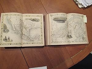
The History And Topography Of The United States Of America. Fourth Edition, With Folding Map "Mexico, California, And Texas. The Newly Discovered Gold Districts" Illustrated By H Warren, Illustrations Engraved By J Rogers, Map By J. Rapkin
Language: English
Published by The London Printing and Publishing Company - Limited, London and New York, 1850
Seller: Arroyo Seco Books, Pasadena, Member IOBA, Pasadena, CA, U.S.A.
Association Member: IOBA
Seller rating 4 out of 5 stars

First Edition
Half Leather. Condition: Good. 3 Colored Maps, 22 Colored Plates, 30 Uncolored Plates (illustrator). First Edition Thus. Two Volumes, Three Quarter Leather. Volume 1: 944 Pp With 30 Uncolored Plates And One Colored Map "Mexico, California, And Texas: The Newly Discovered Gold Districts". Volume Ii: 784 Pp With Two Colored Maps Of Canada, And 22 Colored Plates, All With Yellow Borders And Nice Original Color Throughout. The Map Of Mexico And California, Tipped In But Neatly Loosened And Detached (Without Intention) And Usually Not Present, Has Nicely Detailed Illustrations Of The Ruins At Uxmal, Yucatan, Mexican Peasantry, And Gold Washing, And Outlines The Gold Districts Of The U S And Mexico In Yellow. No Date Of Publication Indicated But Presumably 1850. Bindings Poor, Three Of Four Boards Detached, Spines Perished, Boards Very Worn And Frayed, Deserving Of An Expensive Rebind. Contents Near Fine, Clean, Maps Perfectly Preserved. Volume I With Additional Illustrated Title Page, Showing Penn's Treaty, Painted By Benjamin West And Here Engraved By J. Rogers. This Greatly Enlarged Fourth Edition With The Colored California Gold Map Is Uncommon, About 7 Holdings Shown In Worldcat; It Is Not Listed In Carl Wheat's "The Maps Of The California Gold Region 1848 - 1857", Nor In The Addendum To The 1997 Martino Reprint Of That Book.
-
MAP OF PART OF SOUTH AUSTRALIA Centred Round Spencer Gulf
Language: English
Published by JOHN TALLIS, LONDON, 1850
Seller: K Books Ltd ABA ILAB, York, YORKS, United Kingdom
Association Member: ABA ILAB PBFA
Seller rating 5 out of 5 stars
US$ 116.44
US$ 25.93 shipping
Ships from United Kingdom to U.S.A.Quantity: 1 available
Add to basketNo Binding. Condition: Very Good. H WARREN. J ROGERS J RAPKIN (illustrator). Antique map . Hand coloured, engraved map. mounted - matted - and ready to frame .10 x 13 inches. a vg copy of an attractive decorative hand coloured antique map. . A splendid map, colouring not contemporary but delicately and expertly done - a fine map of part of South Australia with colour washed vignettes of Adelaide, the seal of South Australia, a dingo, aborigines on a Catamaran and a bird called a Nymphicus.
-
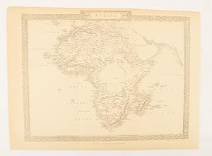
Africa.
Published by The London Printing and Publishing Company. [Circa1880s]., London., 1880
Seller: Asia Bookroom ANZAAB/ILAB, Canberra, ACT, Australia
Association Member: ANZAAB ILAB
Seller rating 5 out of 5 stars
Printed map, 24 x 32.1 cm, decorative border, two original vertical folds, paper toned, mainly at the edges, inner margin of the sheet ragged, but in good order. A late edition of the map used for the well-known Tallis map, this without the characteristic vignettes and on thinner paper.
-
MAP OF VICTORIA, OR PORT PHILLIP, AUSTRALIA.
Language: English
Published by JOHN TALLIS, LONDON, 1850
Seller: K Books Ltd ABA ILAB, York, YORKS, United Kingdom
Association Member: ABA ILAB PBFA
Seller rating 5 out of 5 stars
US$ 136.99
US$ 25.93 shipping
Ships from United Kingdom to U.S.A.Quantity: 1 available
Add to basketNo Binding. Condition: Very Good. A WARREN. J ROGERS J RAPKIN (illustrator). Antique map . Hand coloured, engraved map. mounted - matted - and ready to frame .10 x 13 inches. a vg copy of an attractive decorative hand coloured antique map. . A splendid map, colouring not contemporary but delicately and expertly done - a fine map of Victoria or Port Phillip, with colour washed vignettes of kangaroos, aborigines, Melbourne and the River Glenelg.
-
MAP OF NEW SOUTH WALES, AUSTRALIA.
Language: English
Published by JOHN TALLIS, LONDON, 1850
Seller: K Books Ltd ABA ILAB, York, YORKS, United Kingdom
Association Member: ABA ILAB PBFA
Seller rating 5 out of 5 stars
US$ 136.99
US$ 25.93 shipping
Ships from United Kingdom to U.S.A.Quantity: 1 available
Add to basketNo Binding. Condition: Very Good. H WARREN. J ROGERS J RAPKIN (illustrator). Antique map . Hand coloured, engraved map. mounted - matted - and ready to frame .10 x 13 inches. a vg copy of an attractive decorative hand coloured antique map. . A splendid map, colouring not contemporary but delicately and expertly done - a fine map of New South Wales, Australia with colour washed vignettes of the Murray River, Sydney Cove and a Xanthorrhaea plant.
-

US$ 135.62
US$ 8.64 shipping
Ships from United Kingdom to U.S.A.Quantity: 1 available
Add to basketNo Binding. Condition: Very Good. Original antique map with original hand colouring of the county boundaries as issued. Vignettes of London, Oxford, Portsmouth Harbour, Sunderland Bridge, Newcastle-upon-Tyne, Doncaster Races and Hunting. The border is topped by the Royal coat of arms and with drawings in the corners showing agriculture, commerce, science and the arts. Early edition without centrefold. Full margins all round. Toned verso but not showing on the face. Sold with ivory bevelled mount and a single ruling. Mount window 25.5 x 35.5. Overall size 35.5 x 45.5. The size of the mount makes it a Medium Parcel so shipping in UK �6. Shipped without mount, if preferred. 26.5 x 37 cm.
