
Order Total (1 Item Items):
Shipping Destination:

Map Tardieu (26 results)
Skip to main search results
Search filters
Product Type
- All Product Types
- Books (4)
- Magazines & Periodicals (No further results match this refinement)
- Comics (No further results match this refinement)
- Sheet Music (No further results match this refinement)
- Art, Prints & Posters (No further results match this refinement)
- Photographs (No further results match this refinement)
- Maps (22)
- Manuscripts & Paper Collectibles (No further results match this refinement)
Condition Learn more
- New (No further results match this refinement)
- As New, Fine or Near Fine (No further results match this refinement)
- Very Good or Good (1)
- Fair or Poor (No further results match this refinement)
- As Described (25)
Binding
Collectible Attributes
- First Edition (3)
- Signed (No further results match this refinement)
- Dust Jacket (No further results match this refinement)
- Seller-Supplied Images (25)
- Not Print on Demand (26)
Language (1)
Price
- Any Price
- Under US$ 25 (No further results match this refinement)
- US$ 25 to US$ 50 (No further results match this refinement)
- Over US$ 50
Free Shipping
- Free Shipping to U.S.A. (No further results match this refinement)
Seller Location
Seller Rating
-
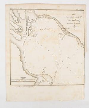
Plan du Port at de la Ville de Kertch, Anciennement Panticap�e
Published by (Librairie de Gide). (1839)., (Paris)., 1839
Seller: Asia Bookroom ANZAAB/ILAB, Canberra, ACT, Australia
Association Member: ANZAAB ILAB
Seller rating 5 out of 5 stars

Engraved map, 21.1 x 20.8 cm, 27 x 22 cm (sheet), original folds trimmed to the inner margin with slight loss to the border only, map spotted, but otherwise in sound condition. Map of the Port of Kerch in Crimea prepared for the 1839 edition of the French Journal "Nouvelles Annales des Voyages.", the editors for this edition (amongst others) the translator and geographer Jean-Baptiste Beno�t Eyri�s and Alexander von Humboldt, founding members of the world's first geographical society, the Soci�t� de G�ographie.
-
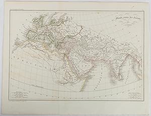
Monde comm des Anciens.
Published by (circa1820)., (Paris.), 1820
Seller: Asia Bookroom ANZAAB/ILAB, Canberra, ACT, Australia
Association Member: ANZAAB ILAB
Seller rating 5 out of 5 stars
Engraved map with original outline hand-colour, 21.1 x 31.5cm, original folds, a few spots and a little creased but in very good condition. Latin map of the Ancient world encompassing Europe, India, Arabia, the Middle East and North Africa, by the French cartographer Jean Baptiste Poirson (1761-1831), finely engraved.
-

Isles Britanniques. Quatrieme carte. Ecosse.
Published by [Paris]: [N.p.], [C. 1798]., 1798
Seller: Spike Hughes Rare Books ABA, Innerleithen, United Kingdom
Seller rating 5 out of 5 stars
Map
US$ 62.17
US$ 34.88 shipping
Ships from United Kingdom to U.S.A.Quantity: 1 available
Add to basketEngraved map. 335 X 440 mm., hand-coloured in outline, numbered No. 14 in top left margin, centre fold, couple of stains in extreme top margin, faint marks in upper left blank area, edges sl. dusty.
-
Includes engraved frontispiece; fold-out engraved map by Pierre Tardieu. (illustrator). Early French translation edition (1829). A scarce four-volume set of Waverley, Sir Walter Scott�s landmark historical novel, here in an 1829 French translation published by the Librairie de Lecointe in Paris. Bound in contemporary quarter calf with marbled paper boards, these two stout tomes contain all four parts. Includes a fine engraved frontispiece scene (�Evan Dhu chez le Baron Bradwardine�) and a large folding map of Scotland engraved by Pierre Tardieu, showing the Jacobite theaters of action. First appearing anonymously in 1814, Waverley is widely regarded as the first historical novel in English literature and the book that made Walter Scott an international literary celebrity. The subtitle ��Tis Sixty Years Since� alludes to the Jacobite rising of 1745, which Scott transformed into a romantic yet deeply researched narrative. The French reading public was especially receptive to Scott�s novels during the Restoration and July Monarchy, both for their evocation of rebellion and their romantic medievalism. This Paris imprint by Lecointe reflects the strong demand for Scott�s works on the Continent, which were often pirated, translated, and circulated widely. Such editions are significant both for literary history and for the study of 19th-century European reception of Scott. Context & Significance: Waverley is the novel that essentially invented the genre of historical fiction, influencing Balzac, Dumas, and beyond. Its French reception was intense: Scott�s novels were read as political allegory in the wake of Napoleon�s defeat and the Bourbon restoration. The engraved map by Tardieu adds cartographic and historical appeal, situating the reader within the Scottish landscape of the rebellion. Collectors value French Scott editions for their rarity compared to English printings, and for their unique Continental publishing history. This 1829 French four-volume-in-two edition of Waverley represents the spread of Scott�s influence across Europe. Featuring both engraved illustration and a folding map, it is a remarkable artifact of the novel�s transnational reach and remains essential to any collection focused on Romantic literature, historical fiction, or cross-cultural print history. Fair to Good. Spines rubbed with wear and some loss to leather, corners bumped, marbled boards scuffed. Internally with expected age toning and foxing, especially to prelims and plates. Map present but with stains, tears along folds, and some loss at edges. Binding remains sound overall. Contemporary quarter leather with marbled boards, gilt spine rules, 4 volumes bound in two. Spine titles �Waverley I�"2� and �Waverley 3�"4.� Rubbing, edge wear, and spine chipping consistent with age.
-

A Chorographical and Statistical Description of the District of Columbia, the seat of the General Government of the United States, with an engraved plan of the District, and view of the Capitol
Published by Paris. Printed and sold by Smith, 1816
First Edition
Hardcover. Condition: Good. 1st Edition. Hardcover. Bound in full leather, a mid-20th-century binding. Brown leather with blue title labels stamped in gold. New endpapers added at that time, as well. Binding is more workmanlike than professional, but still sound and attractive. Title page dated 1816. The name John B Hamilton, MD signed on the title page, with the name Warden, David Baillie written in pencil beneath it. Bottom corner of the title page clipped. 212 pages. Folding engraved map of the Territory of Columbia (12 x 12.5 inches), dated 1815 at the front, in good condition. Drawn by Andrew Ellicott and engraved by P. A. F. Tardieu. The map is an updated version of the 1793 Ellicott Map, which was commissioned by George Washington. This version has streets and buildings added, whereas the 1793 version had only rough outlines of the main avenues. This version has title in English at the top, but otherwise appears identical to the 1815 Tardieu version of the Ellicott map, which has a title on the top in French, but place names on the map itself in English. The map itself is 11 x 11, but it has margins that flesh it out to the dimension given above. Folding engraving of the Capitol, with slight tidal toning at the bottom margin. Plate has a small Univ of Mich rubberstamp in the bottom margin. Folding chart showing information on sheep, also with U of Mich stamp. Final folding chart about banks, also with stamp. No other marks showing long-ago library ownership. Several corrections and notes in ink, presumably nearly as old as the book. Please email with questions or to request photos.
-

Carte d'une Partie des Anambas Reconnue Par M. le Baron de Bougainville.
Publication Date: 1837
Seller: Geographicus Rare Antique Maps, Brooklyn, NY, U.S.A.
Association Member: ABAA ESA ILAB
Seller rating 4 out of 5 stars

Map
Soft cover. Very good. Light wear along original centerfold. Closed margin tear professionally repaired on verso. Size 24.5 x 18.75 Inches. This is an 1828 Ambroise Tardieu map of the northeastern part of Siantan Island and the surrounding islands in the Anambas Islands Regency, part of the Riau Archipelago in Indonesia. Bougainville's expedition marks the first European reconnaissance of the Anambas Islands. A Closer Look Siantan Island occupies the lower left. The Port de Clermont-Tonnerre and the Canal de Clermont-Tonnerre separate Siantan Island from the ' Ile de Bougainville ,' which must be Bajau Island. Parts of the coastline of the ' Ile de Bougainville ' are ghosted in, underscoring the lack of exploration. Several other islands appear above and to the right of Siantan Island, including the ' Ile de la Th�tis ' named after Bougainville's flagship. The routes of the Th�tis and the Esp�rance fill the channels between the islands and anchors mark locations where the two ships anchored during their exploration of the archipelago. The Voyage Around the World by Hyacinthe de Bougainville Hyacinthe Yves Philippe Florentin de Bougainville (December 26, 1781 - October 18, 1846) was a French admiral and the son of the famous navigator Louis-Antoine de Bougainville who successfully completed the first French circumnavigation. The younger Bougainville began his circumnavigation from Brest, France, when he left on March 2, 1824, and returned to Brest on June 23, 1826. Bougainville commanded the frigate Th�tis and the corvette Esp�rance . The French government gave Bougainville secret orders to scout British strongholds throughout the Pacific. The voyage made numerous stops over the 27-month voyage, calling at Pondicherry, Manila, Macau, Singapore, Surabaya, Madura, Port Jackson (Sydney), Hobart, Valparaiso, and Rio de Janeiro. This expedition was the first European expedition to explore and map the Anambas Islands, and it was among the first French expeditions to visit Singapore. The Anambas Islands The Anambas Islands (officially the Anambas Islands Regency) is a small archipelago in Indonesia. The archipelago is situated in the North Natuna Sea, east of Malaysia and west of Borneo. Today, it is administratively a regency of the Riau Islands Province and is home to just over 47,000 people, according to the 2020 Census. Publication History and Census This map was engraved by Ambroise Tardieu after work done by Edmond Bigot de la Touanne during Bougainville's voyage with the lettering engraved by J. P. Besan�on. It was published in 1837 in the atlas that accompanied Bougainville's Journal de la Navigations Autour du Globe de la Fr�gate la Th�tis et de la Corvette l'Esp�rance Pendant les ann�es 1824, 1825 et 1826 . We note two cataloged examples of the separate map, which are part of the collections at the Bayerische Staatsbibliothek and the National Library of Australia. References: OCLC 230188431.
-

Plan du Detroit de Madura depuis la Pointe Panka jusqu'a l'Embouchure de la Riviere de Sourabaya.
Publication Date: 1837
Seller: Geographicus Rare Antique Maps, Brooklyn, NY, U.S.A.
Association Member: ABAA ESA ILAB
Seller rating 4 out of 5 stars
Map
Soft cover. Very good. Size 25 x 17.75 Inches. This is an 1837 Ambroise Tardieu map of the Madura Strait between the islands of Java and Madura in Indonesia. A Closer Look With Java on the left and Madura on the right, the map illustrates the Madura Strait from the north end to the mouth of the Surabaya River. Depth soundings are noted, and the course of the Th�tis is traced through the strait, suggesting the safest route. The Fort d'Orange occupies Menaris Island near the north end of the strait. This is the historic Fort Lodewijk, constructed in 1808 on the orders of the Governor General of the Dutch East Indies, Herman Willem Daendles, to defend against British incursions from the northwest. Towns are labeled on both islands. A view of the Fort d'Orange and the entrance to Madura Strait appears along the bottom border. The Voyage Around the World by Hyacinthe de Bougainville Hyacinthe Yves Philippe Florentin de Bougainville (December 26, 1781 - October 18, 1846) was a French admiral and the son of the famous navigator Louis-Antoine de Bougainville who successfully completed the first French circumnavigation. The younger Bougainville began his circumnavigation from Brest, France, when he left on March 2, 1824, and returned to Brest on June 23, 1826. Bougainville commanded the frigate Th�tis and the corvette Esp�rance . The French government gave Bougainville secret orders to scout British strongholds throughout the Pacific. The voyage made numerous stops over the 27-month voyage, calling at Pondicherry, Manila, Macau, Singapore, Surabaya, Madura, Port Jackson (Sydney), Hobart, Valparaiso, and Rio de Janeiro. This expedition was the first European expedition to explore and map the Anambas Islands, and it was among the first French expeditions to visit Singapore. Publication History and Census This map was engraved by Ambroise Tardieu after work done by Edmond Bigot de la Touanne during Bougainville's voyage with the lettering engraved by J. P. Besan�on. It was published in 1837 in the atlas that accompanied Bougainville's Journal de la Navigations Autour du Globe de la Fr�gate la Th�tis et de la Corvette l'Esp�rance Pendant les ann�es 1824, 1825 et 1826 . We note a single cataloged example of the separate map at the Mus�um National d'Histoire Naturelle in Paris, France. An empty OCLC reference appears for this work, suggesting that an institution that was once part of OCLC cataloged it at one point. References: OCLC 556483233.
-

Plan du Port Clermont-Tonnerre Situe a la Partie Nord-Est des Iles Anambas.
Publication Date: 1828
Seller: Geographicus Rare Antique Maps, Brooklyn, NY, U.S.A.
Association Member: ABAA ESA ILAB
Seller rating 4 out of 5 stars
Map
Soft cover. Very good. Size 20.75 x 18.25 Inches. This is an 1828 Ambroise Tardieu map of the northeastern part of Siantan Island in the Anambas Islands Regency, part of the Riau Archipelago in Indonesia. Bougainville's expedition marks the first European reconnaissance of the Anambas Islands. A Closer Look Part of the northeastern portion of Siantan Island occupies the left half of the sheet, with the 'Port Clermont-Tonnerre' acting as a strait between Siantan and the 'Ile Bougainville' (Bajau Island). Depth soundings are noted, and the conditions of the ocean floor are included. A bay on the Ile Bougainville is labeled ' anse du car�nage ' (bay of anchorage), suggesting that the expedition anchored here and not along the coast of Siantan. The Voyage Around the World by Hyacinthe de Bougainville Hyacinthe Yves Philippe Florentin de Bougainville (December 26, 1781 - October 18, 1846) was a French admiral and the son of the famous navigator Louis-Antoine de Bougainville who successfully completed the first French circumnavigation. The younger Bougainville began his circumnavigation from Brest, France, when he left on March 2, 1824, and returned to Brest on June 23, 1826. Bougainville commanded the frigate Th�tis and the corvette Esp�rance . The French government gave Bougainville secret orders to scout British strongholds throughout the Pacific. The voyage made numerous stops over the 27-month voyage, calling at Pondicherry, Manila, Macau, Singapore, Surabaya, Madura, Port Jackson (Sydney), Hobart, Valparaiso, and Rio de Janeiro. This expedition was the first European expedition to explore and map the Anambas Islands, and it was among the first French expeditions to visit Singapore. The Anambas Islands The Anambas Islands (officially the Anambas Islands Regency) is a small archipelago in Indonesia. The archipelago is situated in the North Natuna Sea to the east of Malaysia and west of Borneo. Today, it is administratively a regency of the Riau Islands Province and is home to just over 47,000 people, according to the 2020 Census. Publication History and Census This map was engraved by Ambroise Tardieu after work done by Edmond Bigot de la Touanne during Bougainville's voyage with the lettering engraved by J. P. Besan�on. It was published in 1837 in the atlas that accompanied Bougainville's Journal de la Navigations Autour du Globe de la Fr�gate la Th�tis et de la Corvette l'Esp�rance Pendant les ann�es 1824, 1825 et 1826 . We note a single cataloged example of the separate map at the National Library of Australia. References: National Library of Australia PIC Volume 584 #S11040/50. OCLC 556921929.
-

Chemins de fer de l'Europe.
Publication Date: 1874
Seller: Geographicus Rare Antique Maps, Brooklyn, NY, U.S.A.
Association Member: ABAA ESA ILAB
Seller rating 4 out of 5 stars
Map
Very good. Minor wear along original centerfold. Original platemark visible. Minor spotting. Size 14.5 x 17 Inches. This is an example of Ambroise Tardieu's 1874 map of Europe showing railways. It covers part of the continent from England south to Spain and the Mediterranean and east as far as Russia. Notes important railway lines as well as shipping lines throughout. This map depicts a period shortly following the unification of Italy and the rise of the British Empire to the apex of power and influence. It was also a time of decline for the Ottoman Empire. This map follows the period immediately after the Franco-Prussian War and the unification of Germany. Throughout, the map identifies various cities, towns, rivers, islands and an assortment of additional topographical details. This map was prepared by Ambroise Tardieu and issued in his 1874 edition of Atlas Universel de Geographie Ancienne et Moderne . References: Rumsey 4697.035 (1863 edition).
-

Espagne and Portugal.
Publication Date: 1874
Seller: Geographicus Rare Antique Maps, Brooklyn, NY, U.S.A.
Association Member: ABAA ESA ILAB
Seller rating 4 out of 5 stars
Map
Very good. Minor wear along original centerfold. Original platemark visible. Minor spotting. Size 15 x 17.5 Inches. This is a fine 1874 map of Spain and Portugal by Ambroise Tardieu. It covers the Iberian Peninsula from France to the Strait of Gibraltar and includes the Balearic Islands of Ibiza, Majorca and Minorca. Throughout, the map identifies various cities, towns, rivers and an assortment of additional topographical details. As this map was being drafted, liberal sentiments within Spain were gaining momentum, leading to the Progressive Biennium, in which the Progressive Party tried to replace the conservative liberalism of the Moderate Party and advocated radical liberalism. This map was prepared by Ambroise Tardieu and issued as plate 18 in his 1874 edition of Atlas Universel de Geographie Ancienne et Moderne . References: Rumsey 4697.022 (1863 edition).
-

France Par Provinces.
Publication Date: 1874
Seller: Geographicus Rare Antique Maps, Brooklyn, NY, U.S.A.
Association Member: ABAA ESA ILAB
Seller rating 4 out of 5 stars
Map
Very good. Minor wear along original centerfold. Original platemark visible. Minor spotting. Size 15 x 17.5 Inches. This is a lovely example of the 1874 map of France by Ambroise Tardieu. The map covers the Kingdom of France showing its various divisions according to province. It covers from the Flanders in the north to Roussillon in the south and from Brittany in the west to Alsace in the east. An inset map on the lower right corner details Corsica. Throughout, the map identifies various cities, towns, rivers, lakes, roadways, railways and an assortment of additional topographical details. France was organized into provinces until March 4, 1790, when the National Constituent Assembly reorganized the Provinces into Departments. The change was an attempt to eradicate local loyalties based on feudal ownership of land and focus all loyalty on the central government in Paris. There were roughly 40 provinces in France before they were abolished. Nonetheless, the province system was so engrained that most cartographers felt obliged to include two maps of France in their atlases, one showing the current department system, and another defining the defunct provinces. This map was prepared by Ambroise Tardieu and issued as plate 11 in his 1874 edition of Atlas Universel de Geographie Ancienne et Moderne . References: Rumsey 4697.015 (1863 edition).
-

France Par Departments.
Publication Date: 1874
Seller: Geographicus Rare Antique Maps, Brooklyn, NY, U.S.A.
Association Member: ABAA ESA ILAB
Seller rating 4 out of 5 stars
Map
Very good. Minor wear along original centerfold. Original platemark visible. Minor spotting and some manuscript marking over the northeast borders of France. Size 15 x 17.5 Inches. This is a fine 1874 map of France divided into its constituent departments by Ambroise Tardieu. It covers from the Nord in the north to eastern Pyrenees in the south and from Finistere in the west to Upper and Lower Rhein in the east. An inset map near the lower right corner details Corsica. The French Department system was established on March 4th, 1790 by theNational Constituent Assemblyto replace the provinces with what the Assembly deemed a more rational structure. They were designed to deliberately break up France's historical regions in an attempt to erase cultural differences and build a more homogeneous nation. Initially there were 83 departments but by 1800 that number increased to roughly 130. Many of the departments that were created in 1790 remain the administrative districts to this day. Nonetheless, the province system was so engrained that most cartographers felt obliged to include two maps of France in their atlases, one showing the current department system, and another defining the defunct provinces. This map was prepared by Ambroise Tardieu and issued as plate 12 in his 1874 edition of Atlas Universel de Geographie Ancienne et Moderne . References: Rumsey 4697.016 (1863 edition).
-

Suede et Danemark.
Publication Date: 1874
Seller: Geographicus Rare Antique Maps, Brooklyn, NY, U.S.A.
Association Member: ABAA ESA ILAB
Seller rating 4 out of 5 stars
Map
Very good. Minor wear along original centerfold. Original platemark visible. Minor spotting. Size 18.5 x 14 Inches. This is a beautiful 1874 map of Scandinavia, including Sweden and Norway by Ambroise Tardieu. It covers from the Arctic south to the Baltic Sea and east as far as St. Petersburg. Two insets in the top right quadrant detail Iceland and the Faroe Islands. Throughout, the map identifies various cities, towns, rivers and an assortment of additional topographical details. At this time in history, Scandinavia was in the midst of a prolonged period of peace that led to a cultural and population boom, especially in Sweden. The economy however could not keep up with the increase in population and much of Sweden's population immigrated to the United States between 1850 and 1910. This map was prepared by Ambroise Tardieu and issued as plate 17 in his 1874 edition of Atlas Universel de Geographie Ancienne et Moderne . References: Rumsey 4697.021 (1863 edition).
-

Asie.
Publication Date: 1874
Seller: Geographicus Rare Antique Maps, Brooklyn, NY, U.S.A.
Association Member: ABAA ESA ILAB
Seller rating 4 out of 5 stars
Map
Very good. Minor wear along original centerfold. Original platemark visible. Minor spotting. Size 15 x 18.5 Inches. This is a beautiful 1874 map of Asia by Ambroise Tardieu. It covers from the Arabian Peninsula and Turkey eastward as far as Kamchatka and Japan and includes the Empires of Hindoostan (India), China (includes Tibet), Persia (Iran), Afghanistan, Beloochistan, Birmah (Burma), Japan, Russia, etc. Also included are portions of Europe and the East Indies. Throughout, the map identifies various railroads, cities, towns, rivers, islands, mountain passes and an assortment of additional topographical details. The map is color coded according to regional and political boundaries with elevation rendered by hachure. Tibet and Korea (Corea) are included within the borders of the Chinese Empire. The disputed body of water between Korea and Japan is here identified as the 'Sea of Japan.' Taiwan or Formosa is mapped vaguely, representing the poor knowledge of the region prior to the Japanese invasion and subsequent survey work in 1895. As this map was drawn, Imperial China wilted under the weak Qing Dynasty while the Russian Empire attained the height of its pan-continental expansion. Turkey and the Middle East were under Ottoman rule while the British Raj governed of India. This map was prepared by Ambroise Tardieu and issued as plate 21 in his 1874 edition of Atlas Universel de Geographie Ancienne et Moderne . References: Rumsey 4697.025 (1863 edition).
-

Iles Britanniques.
Publication Date: 1874
Seller: Geographicus Rare Antique Maps, Brooklyn, NY, U.S.A.
Association Member: ABAA ESA ILAB
Seller rating 4 out of 5 stars
Map
Very good. Minor wear along original centerfold. Original platemark visible. Minor spotting. Size 18 x 14.5 Inches. This is a beautiful 1874 map of the British Isles or Great Britain and Ireland by Ambroise Tardieu. It includes England, Wales, Scotland and Ireland and covers from the Shetland Islands to the English Channel. Throughout, the map identifies various cities, towns, rivers and an assortment of additional topographical details. During this time in history, Scotland was in the midst of the Industrial Revolution and emerging as the center of engineering and shipbuilding in the British Isles. Britain at the time was experiencing a rapid expansion of its empire to include India and parts of Africa. This map was prepared by Ambroise Tardieu and issued as plate 13 in his 1874 edition of Atlas Universel de Geographie Ancienne et Moderne . References: Rumsey 4697.017 (1863 edition).
-

Oceanie.
Publication Date: 1874
Seller: Geographicus Rare Antique Maps, Brooklyn, NY, U.S.A.
Association Member: ABAA ESA ILAB
Seller rating 4 out of 5 stars
Map
Very good. Minor wear along original centerfold. Original platemark visible. Minor spotting. Size 14.5 x 17.5 Inches. This is a fine 1874 map of the Pacific Ocean, including Australia, Polynesia, Melanesia and Malaysia by Ambroise Tardieu. It covers the region in considerable detail with parts of North America and Asia included. Extends as far north as Japan and south to include Auckland Island and New Zealand. This map depicts the continent of Australia with good detail along the coast with a largely unexplored interior. This map also identifies various cities, towns, rivers and an assortment of additional topographical details. This map was prepared by Ambroise Tardieu as plate no. 25 and issued in his 1874 edition of Atlas Universel de Geographie Ancienne et Moderne . References: Rumsey 4697.031 (1863 edition).
-

Environs de Paris.
Publication Date: 1874
Seller: Geographicus Rare Antique Maps, Brooklyn, NY, U.S.A.
Association Member: ABAA ESA ILAB
Seller rating 4 out of 5 stars
Map
Very good. Minor wear along original centerfold. Original platemark visible. Minor spotting. Size 15 x 17.5 Inches. This is a scarce and beautiful 1874 map of Paris and Environs by Ambroise Tardieu. It covers the Seine valley in a roughly 50 mile radius of Paris. Chartres appears in the extreme southwest and Laon in the extreme northeast. It offers extraordinary detail throughout showing forests, fields, roads, cities, farms, rivers, trains, and topographical features. This map was prepared by Ambroise Tardieu and issued as plate no. 29 in his 1874 edition of Atlas Universel de Geographie Ancienne et Moderne . References: Rumsey 4697.033 (1863 edition).
-

Etats-Unis et Mexique.
Publication Date: 1874
Seller: Geographicus Rare Antique Maps, Brooklyn, NY, U.S.A.
Association Member: ABAA ESA ILAB
Seller rating 4 out of 5 stars
Map
Very good. Minor wear along original centerfold. Original platemark visible. Minor spotting. Size 15 x 17 Inches. This is a scarce 1874 map of the United States and Mexico by Ambroise Tardieu. It covers the entirety of the United States and Mexico including parts of the West Indies. Although the map was published in 1874, cartographically it dates to 1849, right after the Mexican American War. Notes various territories in the west, including the Oregon Territory, the Northwest Territory, Indian Territory and New California. In modern terms this includes an exceptionally important representation of all parts of the United States west of the Mississippi including Washington, Oregon, California, Nevada, Arizona, Utah, New Mexico, Idaho, Montana, Wyoming, Colorado, Kansas, Nebraska, North Dakota, South Dakota, Missouri, Arkansas, Louisiana and Oklahoma. Texas is at its largest. Throughout, the map identifies various cities, towns, rivers, islands, mountain passes and an assortment of additional topographical details. This map was prepared by Ambroise Tardieu as plate no. 25 and issued in his 1874 edition of Atlas Universel de Geographie Ancienne et Moderne . References: Rumsey 4697.029 (1863 edition).
-

Esquisse des rivieres Muskinghum et Grand Castor que j'ai tiree du Journal du General Bouquet.
Publication Date: 1787
Seller: Geographicus Rare Antique Maps, Brooklyn, NY, U.S.A.
Association Member: ABAA ESA ILAB
Seller rating 4 out of 5 stars
Map
Very good. Original folds visible, else excellent with a deckled bottom edge. Size 9.5 x 21 Inches. This is a scarce 1787 Pierre Tardieu map of the Ohio River and its tributaries. A Closer Look This is one of the earliest maps of the region, here divided into three maps. The large map at left depicts the course of the Ohio River from western Pennsylvania to the confluence of the Hockhoking River. The Sandusky River, which flows north into Lake Erie, appears at the top of the map. Its primary focus is the course of the Muskinghum River, the largest of the Ohio's tributaries and the site of many indigenous and European settlements. The center map depicts the Scioto River and its various tributaries, showing many indigenous settlements in the future location of Columbus, Ohio. The third map features the River Grand Castor - now known as the Beaver River, in Western Pennsylvania - and its tributaries. As in the other two maps, native and European settlements are noted throughout, with mountains beautifully rendered in profile. All three maps note sources for salt, trails between settlements, and native warpaths. Publication History Based on earlier maps from Bouquet and Hutchins, this map was issued in the 1787 French edition of J. Hector St. John de Crevecoeur's Letter from an American Farmer Though we are aware of examples that have come on the market, this map only appears separately in only four institutional collections. References: OCLC: 262297924.
-

Plan de Pampelune relatif a la Defense de Cette Place par les Francais en 1813.
Publication Date: 1836
Seller: Geographicus Rare Antique Maps, Brooklyn, NY, U.S.A.
Association Member: ABAA ESA ILAB
Seller rating 4 out of 5 stars
Map
Very good. Light wear along original centerfold. Closed margin tears professionally repaired on verso. Size 25 x 34.75 Inches. This is an 1836 Jacques-Vital Belmas city plan or map of Pamplona, Spain, during the 1813 Siege of Pamplona, one of the battles in the larger Peninsular War (1808 - 1814). The besieged French forces managed to hold out for over four months, delaying Wellington's advance into France, since he refused to move into France until after Pamplona had fallen. The result of meticulous military surveys, this is one of the best large-format maps of Pamplona to appear in the early 19th century. A Closer Look Pamplona's citadel appears in detail connect to the larger city walls. Streets are illustrated within the walled city along with the esplanade and the city gates. Two forts appear above the city to the left of the citadel. The city's environs are illustrated in detail. Buildings and streets appear within walled towns and unwalled villages, while rivers meander through the countryside providing natural fortifications. The positions of English and French soldiers appear along the bottom border, with English forces holding the high ground. Siege of Pamplona (June 26 - October 31, 1813) The Siege of Pamplona was part of the Peninsular War, fought by the invading First French Empire agaisnt Spain, Portugal, and the United Kingdom between May 2, 1808 - April 17, 1814. It was part of the larger Napoleonic Wars (May 18, 1803 - November 20, 1815). The siege began on June 26, 1813, after the decisive June 21st Battle of Vitoria, a rare victory over the French by an English-led coalition under the future Duke of Wellington. Following the battle, Wellington pursued the retreating French in addition to detaching 10,000 men to lay siege to Pamplona, where 3,800 French troops were garrisoned. French forces tried to relieve their besieged comrades in late July but were repulsed. The French in Pamplona, having run out of supplies, surrendered on October 31 with roughly 500 killed, 899 wounded, and 2,150 captured. Publication History and Census This map was engraved by Ambroise Tardieu for inclusion in Jacques-Vital Belmas's (1792 - 1864) Journaux des si�ges faits ou soutenus par les Fran�ais dans la P�ninsule, de 1807 � 1814 . We note one cataloged example of the separate map, at at the Biblioth�que nationale de France. The book and the accompanying atlas are however, well represented in institutional collections. References: OCLC 762920532.
-

Carte De La Partie Septentrionale Des Etats-Unis.
Publication Date: 1801
Seller: Geographicus Rare Antique Maps, Brooklyn, NY, U.S.A.
Association Member: ABAA ESA ILAB
Seller rating 4 out of 5 stars
Map
Very good. Some offsetting. Wear on original fold lines. Size 14 x 20 Inches. An important and highly detailed 1801 map of the northeastern United States by Pierre Francis Tardieu. The map was issued to a accompany Michel Guillaume de Crevecoeur's Le Voyage dans la Haute Pennsylvania et dans l'�tat de New-York , one of the most important post-Revolutionary War books about life and economy in the fledgling United States. Coverage extends from Maine to the District of Columbia and west as far as Ohio and the Connecticut Reserve, including modern-day New England, New York, New Jersey, Pennsylvania, and parts of Maryland, Delaware, and West Virginia. The map is notable for its exceptional detail, naming towns and roads, as well as surveyed military tracts intended to compensate Revolutionary War soldiers for their war effort. Central New York Military Tract The Military Tract of Central New York, also called the New Military Tract, consisted of nearly two million acres (8,100 km2) of bounty land set aside in Central New York to compensate New York's soldiers for their participation in the Revolutionary War. Soldiers were guaranteed 500 acers each from the newly laid down tracks. These lands were carefully surveyed out in the Finger Lakes region of New York - north of Oswego and west of Cooperstown, covering the modern-day counties of Cayuga, Cortland, Onondaga, and Seneca, and parts of Oswego, Tompkins, Schuyler and Wayne. Apparently at the whim of Robert Harpur, a clerk in the office of New York's Surveyor General, the new townships were named after figures from classical antiquity, including Greek and Roman statesmen and the Carthaginian general Hannibal. Connecticut Western Reserve At the far western section of the map, on the shores of Lake Erie, the Connecticut Western Reserve is noted. This section of northeastern Ohio, rarely seen on maps, was ceded to Connecticut by King Charles II in exchange for Westmoreland County, Pennsylvania, following the Yankee-Pennamite Wars. Connecticut gave up its claims to the Western Reserve in 1800, when they were sold to the Connecticut Land Company, a group of speculators based in Suffield, Connecticut. Surveyors were sent out, under Moses Cleveland, to divide the reserve into township and found the city of Cleveland, first known as 'New Salem.' Publication History and Census This map was engraved in Paris by Pierre Francis Tardieu for inclusion in Michel Guillaume de Crevecoeur's Le Voyage dans la Haute Pennsylvania et dans l'�tat de New-York . Despite being his longest and most comprehensive work on the Americas, it never attained the popularity of the 1784 Letters d'un Cultivateur Am�ricain . There were multiple editions of the book, but only one of the map. Today this map is uncommon on the market and its significance often underappreciated. The OCLC identifies 3 examples of the separate maps. References: OCLC. 58915829.
-
![Seller image for [New England]. for sale by Geographicus Rare Antique Maps](https://pictures.abebooks.com/inventory/md/md32117353263.jpg)
[New England].
Publication Date: 1812
Seller: Geographicus Rare Antique Maps, Brooklyn, NY, U.S.A.
Association Member: ABAA ESA ILAB
Seller rating 4 out of 5 stars
Map
Very good. Dissected and laid on linen. Original linen stable. Slight toning. Size 24.75 x 28.75 Inches. The northeastern sheet of Pierre Francois Tardieu's 1812 four-sheet map of the United States of America, based on Aaron Arrowsmith's seminal 1796 map of the same. Its publication coincided with the outbreak of the War of 1812 (1812 - 1815). Aside from its aesthetic qualities and level of detail, the map is notable for demonstrating the territorial evolution of the new republic. A Closer Look Coverage includes the northeastern portion of the new United States of America as well as various provinces of British North America (Canada). Settlements, including Native American villages, are recorded in considerable detail, along with mountains, rivers, lakes, forts, mills, mines, and roads (with distances noted between settlements). Town lines are traced in Canada and Upstate New York, including those drawn from the Central New York Military Tract ('Concession militaire'), awarded to veterans of the Revolutionary War. Some placenames are retained that would become uncommon or anachronistic in later times; for instance, the White Mountains are recorded here as the 'White Hills,' as was fairly common at the time. The map includes a combination of French ('Limite des Indiens,' 'Pays de Genes�es') and English placenames and explanatory notes. Publication History and Census This map constitutes one sheet of a four-sheet map ('United States of Nth. America Carte des Etats-Unis de l'Am�rique Septentrionale'), produced by a member of the Tardieu cartographic clan (most likely Pierre Francois Tardieu, 1757 - 1822). Engraving is attributed to Jean-Claude Dezauche, Charles Picquet, and Jean Goujon. It is based on Aaron Arrowsmith's influential 1796 'A Map of the United States of North America,' which was then updated and reissued several times. However, Tardieu did not simply copy and translate Arrowsmith's map as it was but added whatever new information could be gathered. Tardieu produced at least four editions of the map, in 1802, 1808, 1812, and 1820, which can be readily distinguished by features on the map. The edition dated 1812 exists in three states, which were produced c. 1812, 1816, and 1818, respectively, which can also be distinguished based on territorial changes on the American frontier. Usually, the territories in the south and west of the country are used to determine the state of the dated 1812 map, which does not help here, but there are other features that suggest that the present map is an earlier state, most likely the earliest (c. 1812) state. Most obviously, a notable element lacking here that does appear on later states is Cleveland, Ohio, as well as a road running parallel to the coast of Lake Erie from Buffalo ('Buffaloe') to Cleveland and onwards. Regardless of state, the OCLC notes the 1812 edition of the map in 10 institutions worldwide. References: Rumsey 4193.003. OCLC (all 1812 states) 16650791, 431784783, 1090811574, 850209252.
-

Carte de L'Ile de Martha's Vineyard avec ses dependances, pour les Lettres d'un Culuvateur Ameriquain.
Publication Date: 1785
Seller: Geographicus Rare Antique Maps, Brooklyn, NY, U.S.A.
Association Member: ABAA ESA ILAB
Seller rating 4 out of 5 stars
Map First Edition
1st Edition. Very good. Faint stain; marginal mend at insertion point with no impact to image. Size 9 x 11 Inches. This small but important map by P. F. Tardieu is the earliest obtainable separate map of Martha's Vineyard, Massachusetts. A Closer Look Coverage embraces Martha's Vineyard in full, as well as parts of the adjacent Elizabeth Islands. The map extends northwards to include Buzzards Bay and southwards as far as Nomans Land Island, now a wildlife refuge. On the Vineyard, details include roads, natural features, towns and villages, and two meeting houses. Tardieu locates Edgartown, Tidsbury Wood, Tidsbury Town, Chappaquiddick (Chapoquidick), Eel Pond, Peat Swamp, Squidnoket Pastures, and Cape Pog Pond, etc. Although published in Paris for a French audience, most of the text is in English. The exception is the title and a key in the upper right identifying ten additional numbered locations. Letters of an American Farmer This map was prepared to accompany Michel Guillaume St. Jean de Crevecoeur's 1787 Lettres d'un Cultivateur Ameriquain (Letters of an American Farmer), a collection of essays describing American life in such bountiful language that it inspired a wave of French immigration to North America. Howes describes Crevecour's work as a 'description of American life of great influence in attracting European immigration in the post-revolutionary period. As literature unexcelled by any American work of the eighteenth century.' Publication History and Census This map was engraved in 1785 by Pierre Francis Tardieu, whose imprint appears in the lower right. It was not published until two years later, in 1787, when the first French edition of Michel Guillaume St. Jean de Crevecoeur's 1787 Lettres d'un Cultivateur Ameriquain was issued. The map is based upon a similar map issued in the 1783 English edition, Letters of an American Farmer , but it is much more finely engraved, reflecting Tardieu's mastery. There also exists a similar map of Nantucket. Always desirable, these maps come rarely to the market. References: Phillips (America) p. 389. Howes, W., U.S.iana (1650-1950): A Selective Bibliography in which are Described 11,620 Uncommon and Siginficant Books Relating to the Continental Portion of the United States, #C883.
-

Carte Generale des Etats de Virginie, Maryland, Delaware, Pensilvanie, Nouveau-Jersey, New-York, Connecticut et Isle de Rhodes Ainsi que des Lacs Erie, Ontario, et Champlain. D'Apres la Carte Ameriquaine de Louis Evans et la Carte Anglaise de Thomas-Jefferys, pour les Lettres d'un Cultivateur Ameriquain.
Publication Date: 1787
Seller: Geographicus Rare Antique Maps, Brooklyn, NY, U.S.A.
Association Member: ABAA ESA ILAB
Seller rating 4 out of 5 stars
Map
Very good. Mended tear at insertion point with no loss. Faint offsetting. Size 19.5 x 26 Inches. An elegant 1787 French edition of Louis Evans' seminal and influential map of the Middle British Colonies, one of the most important maps of the British colonies and the best colonial mapping of the Ohio River Valley. It was issued for Michel Guillaume St. Jean de Crevecoeur's 1787 Lettres d'un Cultivateur Ameriquain , one of the most influential works on colonial America. Coverage The map covers from Louisville on the Ohio River eastward as far as Narragansett Bay and Long Island, northwards as far as Montreal, and south to the mouth of the Chesapeake Bay, inclusive of Lake Erie, Lake Ontario, and most of the Ohio River Valley. A large inset map in the upper left, as indicated in its title, shows the remaining westward course of the Ohio River, but it also reveals the upper Mississippi River, the Illinois River, and the relationship of those rivers to Lakes Michigan and Huron. Milestone Geography Along with Mitchell's map of North America issued in the same year, the 1755 Evans map is considered a milestone for 18th-century American cartography. Both maps were designed to spur colonial expansion into the Trans-Allegheny - what is today western Pennsylvania, Ohio, West Virginia, and Kentucky. According to Schwartz, the Evans map was 'the most ambitious performance of its kind undertaken in America up to that time,' and McCorkle considers it 'one of the most important maps made in the colonial period.' Unlike most previous maps of this region, including the Mitchell map referenced above, Evans based this map heavily on his own actual survey work. He supplemented this with firsthand reports from frontiersmen and guides who were well acquainted with the area. Evans issued this map in the opening years of the French and Indian War. Even after the conflict, his map offered a solid foundation for settlers to occupy the territory, which passed into British hands. The quality of the map and its long-standing influence are revealed by the map's long, albeit unauthorized, print history: Evans' work would remain the definitive geography of the region for over 50 years. A Closer Look In addition to its broader significance, this map abounds with fine detail - the kind of information that would be exceptionally useful for a prospective settler - and rewards close study. It depicts hundreds of European and Native American settlements, as well as numerous roads and the sites of swamps, mountains, resources, and important portages. In addition, Dartmouth College is identified on the Connecticut River, 'elephant bones' and 'Antiques Sculptures' in Ohio, salt and limestone quarries throughout, petroleum in western Pennsylvania, and coal deposits. Updates This French edition is not merely a slavish reissue of American and British work. The French had considerable knowledge of this region, far more than the British, and numerous valuable additions are apparent throughout. The tributaries of the Ohio River are shown in greater detail than in any other iteration of the Evans. The Niagara River Valley also features more detail. This Tardieu edition of the map is the only version of the Evans to include the border between New York and Pennsylvania. Kentucky is (prematurely) named as a state; there are early references to important cities, including Louisville and Leestown, which was the first Anglo-American settlement on the north side of the Kentucky River and is now part of Frankfort. The map names numerous American Indian tribes. The inset map also includes the Portage of Chikago (Chicago), as well as Fort Erie and St. Louis. Publication History and Census As with most great maps, the Evans map was extensively reissued and pirated, going through 27 known editions over 50 years. The present example was re-engraved by Pierre Tardieu based upon Jefferys' plagiarization of Evans' original. It was intended for publication in accompaniment of Michel Guillaum.
-

Carte Generale de L'Empire de Russie 1787.
Publication Date: 1787
Seller: Geographicus Rare Antique Maps, Brooklyn, NY, U.S.A.
Association Member: ABAA ESA ILAB
Seller rating 4 out of 5 stars
Map
Good. Edges trimmed near neatline, likely by publisher. Size 22.25 x 47.5 Inches. An intricate large-scale c. 1787 French-language map of the Russian Empire engraved by Pierre-Fran�ois Tardieu. It represents a significant improvement on earlier maps of the empire, especially its eastern portions and the northern Pacific, as both Russian and western European voyages of exploration proliferated in the late 18th century. A Closer Look Coverage stretches from what is now Poland, Ukraine, and Estonia in the west to Alaska and the Kuril Islands in the east, including recent acquisitions made under Catherine the Great, most notably Crimea, which was conquered from the Ottomans in 1783. Roads, waterways, mountains, settlements, and administrative borders are indicated throughout. Descriptive notes on recent voyages and discoveries are included along Russia's northern coast and in the bottom-right. Although an important advance on earlier maps, the geography of some areas, such as Sakhalin (Sahalien-Ouha) and Hokkaido (Yeso), is still 'under development,' as Tardieu freely admits. Nearby, the tracks of Russian expeditions to the Kuril Islands are recorded. Seven scales are provided, in part to account for the modified conic projection employed. This map was produced at a time when Russia's empire was near the peak of its expansion and interest in Siberia, the Pacific, and Alaska at its apex. In 1799, Tsar Paul I provided a charter for the Russian-American Company and established territorial claims to much of today's Alaska. In the following decades, Russian traders would range as far south as Hawaii and the San Francisco Bay Area. But the rapid depletion of fur stocks and more pressing concerns closer to the imperial center of Moscow-St. Petersburg, namely the Napoleonic Wars (1803 - 1815), caused Russian interest in the northern Pacific to wane in the early 19th century, allowing Britain and the United States to become preeminent in the region. Early Revelation of Perouse's Discoveries This map was engraved by Pierre-Fran�ois Tardieu and is dated 1787, though the note at bottom-right mentions subsequent updates, including the incorporation of information from the voyage of La Perouse ('Peyrouse' here), which was not openly published until 1797. The map appeared in Vol. 6 of Peter Simon Pallas' Voyages en diff�rentes provinces de l'Empire de Russie, et dans l'Asie septentrionale , published in 1793, a date consistent with the empire's borders, just on the eve of the Second Partition of Poland-Lithuania. These facts suggest that Tardieu had advanced knowledge of Perouse's discoveries, which is plausible as the expedition's journals were sent overland from Kamchatka across Russia with a stopover in St. Petersburg in 1788, where they were delivered to the French ambassador and then sent on to Paris. Either by way of interlocutors in St. Petersburg or through his proximity to the French crown, Tardieu's inclusion of said information was an early publication of Perouse's discoveries. Publication History and Census More generally, Tardieu's map is based on a Russian original ('??????????? ????? ???????????? ???????') first published in 1776 by the Imperial Academy of Sciences (????????????? ???????? ????) in St. Petersburg by a team including the prolific cartographer Ivan Treskot. It was revised and reissued several times thereafter as Russian geographical knowledge of the further reaches of Siberia and the Pacific, and of scientific cartography more generally, was developing rapidly at this time, and Tardieu looks to have used the 1787 edition of the Russian map as his basis. This map is only independently cataloged with the Newberry Library, Harvard University, and the National Library of Scotland, while Pallas' entire Voyages is more widely distributed. Yale University's Beinecke Rare Book and Manuscript Library holds a slightly different 1785 edition also attributed to Tardieu. References: OCLC 219450868, 316509383.
-

Carte De La Partie Meridionale Des Etats-Unis.
Publication Date: 1801
Seller: Geographicus Rare Antique Maps, Brooklyn, NY, U.S.A.
Association Member: ABAA ESA ILAB
Seller rating 4 out of 5 stars
Map First Edition
1st Edition. Good. Marginal toning. Some mends at folds. Margin reinstated at upper left, not impacting printed image. A bold, sharp strike. Size 16 x 21 Inches. An important and highly detailed 1801 map of the southeastern United States by Pierre Francis Tardieu. The map was issued to accompany Michel Guillaume de Crevecoeur's Le Voyage dans la Haute Pennsylvania et dans l'�tat de New-York , one of the most important post-Revolutionary War books about life and economy in the fledgling United States. Coverage extends from the Chesapeake Bay and the Ohio River south as far as central Georgia, including the modern-day states of Virginia, Kentucky, Tennessee, North Carolina, South Carolina, and parts of Georgia and Alabama. The map is notable for its exceptional detail, naming towns, mills, mines, and roads, as well as surveyed tracts intended to compensate Revolutionary War soldiers for their effort. An Unusual Strip of Land The careful observer will note an 11-mile-wide strip of land separating Tennessee and Georgia. This is a legacy of the old coast to coast royal charters upon which the South Carolina and Georgia were initially established. For a time both Georgia and North Carolina claimed this strip of land, although it was hardly disputed being a remote and mostly unsettled bit of territory. After the American Revolutionary War, when Georgia and South Carolina met at the Convention of Beaufort to negotiate their formal boundary, George ceded the territory. A few months later, South Carolina also ceded the territory, this time to the United States. Georgia at the time, as on this map, was a sprawling territory extending westward as far as the Mississippi River. When Alabama and Mississippi were created, part of this strip was ceded back to Georgia. This cartographic anomaly appeared on certain derivative maps until about 1844, by which time much had changed in the region. Publication History and Census This map can trace its origins to an obscure map published in 1799 by Francois-Alexandre-Frederic, Duc de La Rochefoucauld-Liancourt (1747 - 1827). Although liberal and a reformer, Liancourt's noble status forced him to flee France during the French Revolution. He lived briefly in England before traveling extensively in the United States. He returned to France in 1799, compiling an 8-volume travelogue of his adventures in the United States, Voyage dans les �tats-Unis d'Am�rique, fait en 1795, 1796 et 1797 . When Pierre Francis Tardieu was contracted to engrave this map for Michel Guillaume de Crevecoeur's Le Voyage dans la Haute Pennsylvania et dans l'�tat de New-York , he most have turned to Liancourt as the most up-to-date French source on the cartographic disposition of American southeast. This present example is the 1801 first edition. This important map is uncommon on the market, but well represented institutionally. References: OCLC 873730198.

