
Order Total (1 Item Items):
Shipping Destination:

Menke Th (44 results)
Author:
menke th
Refine with Advanced Search
Skip to main search results
Search filters
Product Type
- All Product Types
- Books (30)
- Magazines & Periodicals (No further results match this refinement)
- Comics (No further results match this refinement)
- Sheet Music (No further results match this refinement)
- Art, Prints & Posters (14)
- Photographs (No further results match this refinement)
- Maps (No further results match this refinement)
- Manuscripts & Paper Collectibles (No further results match this refinement)
Condition Learn more
- New (9)
- As New, Fine or Near Fine (No further results match this refinement)
- Very Good or Good (17)
- Fair or Poor (No further results match this refinement)
- As Described (18)
Binding
Collectible Attributes
- First Edition (No further results match this refinement)
- Signed (No further results match this refinement)
- Dust Jacket (No further results match this refinement)
- Seller-Supplied Images (35)
- Not Print on Demand (36)
Language (4)
Free Shipping
Seller Location
Seller Rating
-
![Seller image for Orbis Antiqui Descriptio [cartographic Material]: an Atlas Illustrating Ancient History and Geography by Eighteen Maps for sale by AHA-BUCH GmbH](https://pictures.abebooks.com/inventory/md/md31915220647.jpg)
Orbis Antiqui Descriptio [cartographic Material]: an Atlas Illustrating Ancient History and Geography by Eighteen Maps
Language: English
Published by Creative Media Partners, LLC Sep 2021, 2021
ISBN 10: 1015083803 ISBN 13: 9781015083806
Taschenbuch. Condition: Neu. Neuware.
-

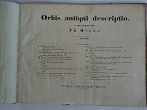
Orbis Antiqui Descriptio. In usum scholarum edidit. 11 Seiten Text, 18 doppelseitige kolorierte Karten. Editio Quarta.
Published by Gotha, Perthes, MDCCCLXV.
Seller: Fachbuchhandlung H. Sauermann, Radebeul, Germany
Association Member: BOEV
Seller rating 4 out of 5 stars

Gr. 8�. Olwd. Einband st�rker berieben und besto�en, Seiten etwas fleckig.
-

Orbis Antiqui Descripto, An Atlas Illustrating Ancient History and Geography By Eighteen Maps
Published by Justus Perthes / TRUBNER & Co, Gotha / London, 1866
Seller: PsychoBabel & Skoob Books, Didcot, United Kingdom
Seller rating 5 out of 5 stars

US$ 67.70
US$ 16.77 shipping
Ships from United Kingdom to U.S.A.Quantity: 1 available
Add to basketHardcover. Condition: Good. Dust Jacket Condition: No Dust Jacket. Hardcover with gilt lettered front board, no dust jacket, in good condition. Boards are scuffed and marked, with some surface colour loss. Edges, corners and spine ends are bumped, rubbed and torn. Page block, pastedowns and endpapers are tanned. Previous owner's name penned to front end-paper. Binding is sound and pages are clear. LW. Used.
-
Orbis Antiqui Descriptio. In Usum Scholarum Edidit. Editio Quarta.
Published by Gotha, Perthes, 1865., 1865
Seller: Antiquariat MEINDL & SULZMANN OG, Wien - Vienna, Austria
Seller rating 5 out of 5 stars
4�. Mit 18 gestochenen, farbigen Karten. 1 Bl., 11 SS. Blindgepr. OLn. mit goldgepr. Titel a.d. Vorderdeckel (gering fleckig. Ecken und Kanten leicht besto�en). Enth�lt: 1) Aegyptus ante Cambysis tempus.- 2) Regnum Assyrium, Aegyptus . ad annum 627 a. Chr.- 3) Regnum Persicum usque ad Herodoti tempus.- 4) Maris Aegaei littora belli Peloponnesiaci tempore.- 5) Graecia belli Peloponnensi tempore.- 6) Regni Persici satrapiae inferiores, Graecia.- 7) Regni Persici satrapiae superiores Alexandri Magni.- 8) Regna successorum Alexandri Magni.- 9) Roma cum populis finitimis.- 10) Italiae pars septentrionalis, Ligures.- 11) Italia pars meridionalis, Sicilia.- 12) Maris interni littorum pars occidentalis.- 13) Maris interni littorum pars orientalis.- 14) Gallia Caesaris tempore.- 15) Iudea, Phoenice, Coelesyria Christi.- 16) Imperium Romanum inde ab Augusti tempore.- 17) Italia, Sicilia imperatorum Romanorum temporis.- 18) Britannia, Germania, Raetia.- Titel gestempelt. Papier etw. gebr�unt. Die Karten in sauberem Erhaltungszustand.
-
![Stock image for Orbis Antiqui Descriptio [cartographic Material] : an Atlas Illustrating Ancient History and Geography by Eighteen Maps for sale by Ria Christie Collections](https://pictures.abebooks.com/isbn/9781015083806-us-300.jpg)
Orbis Antiqui Descriptio [cartographic Material] : an Atlas Illustrating Ancient History and Geography by Eighteen Maps
Seller: Ria Christie Collections, Uxbridge, United Kingdom
Seller rating 5 out of 5 stars
US$ 17.40
US$ 16.07 shipping
Ships from United Kingdom to U.S.A.Quantity: Over 20 available
Add to basketCondition: New. PRINT ON DEMAND Book; New; Fast Shipping from the UK. No. book.
-

Orbis antiqui descriptio. In usum scholarum edidit.
Language: German
Published by Perthes. Gotha., 1860
Seller: Antiquariat im Schloss, Schwaigern, D, Germany
Seller rating 5 out of 5 stars
hardcover. 3. Auflage. 10 S., Tafelteil. 4� (quer). HLeder d. Z. St�rker berieben und besto�en; einige Tafeln lose und anger�ndert; fingerfleckig; Name auf Titelei. Sonst guter Zustand. Mit 42 Karten und Pl�nen auf 18 grenzkolorierten Kupfertafeln. Sprache: Deutsch Gewicht in Gramm: 800.
-
Orbis Antiqui descriptio. In usum scholarum edidit. Editio Quarta.
Published by Gotha Perthes, 1865
Seller: Libretto Antiquariat & mundart.ch, Langnau i.E., BE, Switzerland
Seller rating 5 out of 5 stars
Original-Leinenband mit Blind- und Goldpr�gung, mit 18 doppelseitigen kolorierten Karten, 11 Seiten Text, 17,5 x 25 cm, Einband an den Kanten berieben, gutes Exemplar.
-
Orbis antiqui description. In usum scholarum edidit
Seller: Celler Versandantiquariat, Eicklingen, Germany
Association Member: GIAQ
Seller rating 5 out of 5 stars
2. Auflage, Sumtibus Iusti Perthes, Gothae, 1854. 1 Titelblatt, 8 S. Text und 17 grenzkolorierte Karten des Perserreiches und Europas, Halbleinen-Einband, quart-quer, (gering fleckig/etwas berieben)--- 480 Gramm.
-
Orbis Antiqui Descriptio [cartographic Material]: an Atlas Illustrating Ancient History and Geography by Eighteen Maps
Seller: THE SAINT BOOKSTORE, Southport, United Kingdom
Seller rating 5 out of 5 stars
US$ 22.75
US$ 16.51 shipping
Ships from United Kingdom to U.S.A.Quantity: Over 20 available
Add to basketPaperback / softback. Condition: New. This item is printed on demand. New copy - Usually dispatched within 5-9 working days.
-
Orbis antiqui desscriptio. in usum scholarum edidit. Atlas. 4. Aufl.
Published by Gotha, Perthes, ., 1865
18 doppel- blattgr. Karten, 11 S. dunkelgr�ner Orig. Leinenband mit blind- und Goldpr�g. beilieg: 6 Karten aus Stielers Schulatlas ca. 1860, (die Karten grenzkol.; teils mit Bleistifteintragungen, sonst gut).
-
Hardcover. Condition: Gut. 4. Auflage. In Usum Scholarum Edidit 8 Original-Leinen Kein Schutzumschlag Buch 11 SS und 18 kolorierte Karten, goldgepr. OLn. (angestaubt, gering fl., ber. u. best.), Textteil fleckig, Karten sauber und gut Gut.
-

Orbis Antiqui Descriptio, an Atlas Illustrating Ancient History and Geography by Eighteen Maps
Published by Trubner & Co., London
Seller: Burton Lysecki Books, ABAC/ILAB, Winnipeg, MB, Canada
Seller rating 5 out of 5 stars
1862, 3rd edition, revised and corrected. (Hardcover) Good. 15pp. plus 17 maps. 17 mounted folding maps (lacks map 4) with colored borders. The cloth on the front cover is torn and partially missing, the front endpaper is half torn away, a previous owner's name inside. Internally the maps are overall in clean condition with the following exceptions: most have a small dampstain at the top fold in the margin area, map 3 has small ink stains at outer edge well away from the map, map 5 is worn at the bottom edge and there is a small tear at the bottom fold, map 10 has some small stains on the map and a small tear at the bottom fold, map 12 has some spotting and a few small ink stains, map 13 has some minor spotting and a tear half way up the fold, map 18 is not quite as clean as the others. (Atlases, Atlases, History--Ancient).
-
Orbis Antiqui Descriptio, an Atlas illustrating Ancient History and Geography by Eighteen Maps
Published by J. Perthes,, Gotha, 1878
Seller: Magdeburger Antiquariat, Magdeburg, ST, Germany
Seller rating 5 out of 5 stars
Fourth Edition, revides a. corrected. Gr.-8vo. Mod. Lwd.-Einband. Beiheft eingebunden (12 S.). Die 18 Karten in sehr guter Erhaltung. Sehr gutes Exemplar.
-
Sammelband:1. Orbis antiqui descriptio. 2. Historisch-Geographischer Schul-Atlas.
Published by Gotha, Perthes, 1854 u. 1856., 1854
Seller: Antiquariat Kunsthaus-Adlerstrasse, Stuttgart, Germany
Seller rating 5 out of 5 stars
Durchgehend mit XVII und XXII ganzseitigen Karten. Einb. mit Gebrauchsspuren, Vorsatz u. Titelblatt mit Knickspuren, Vermerk auf Vorsatz, Seiten etw. fingerfl. u. teilw. braunfl. Sprache: Deutsch Quer-4�, goldgepr. Orig.-Halbleder.
-
[ATLAS] SPRUNER-MENKE HAND-ATLAS FUR DIE GESCHICHTE DES MITTELALTERS UND DER NEUREN ZEIT DRITTE AUFLAGE
Published by Justus Perthes, Gotha, 1880
Seller: BLACK SWAN BOOKS, INC., ABAA, ILAB, Richmond, VA, U.S.A.
Association Member: ABAA ESA ILAB
Seller rating 5 out of 5 stars
Hard Cover. Condition: Near Fine binding. Folio; rebound in green cloth with titling in gold to the spine; [ii],[2], 3-42 pages, followed by 89 of 90 double-paged maps [NOTE: this copy appears to be lacking Map VIII: Europa wahrend des Zeitraums der Reformation und der Uebermachtdes Hauses Hapsburgh 1492-1618]; the maps are steel-engraved, with coloring to the borders of the countries; one maps in color lithography.~~This copy is bound quite tightly -- so tightly that it does not lie flat when opened and to the extent that some text and perhaps some part of maps are down in the gutter. Near Fine binding.
-
Iberische Halbinsel .
Published by Spagna - Portogallo (Espa�a - Portugal)
Seller: Sergio Trippini, Gavirate, VA, Italy
Seller rating 4 out of 5 stars
Carta geografica della Penisola Iberica.
-
Iberische Halbinsel .
Published by Spagna - Portogallo (Espa�a - Portugal)
Seller: Sergio Trippini, Gavirate, VA, Italy
Seller rating 4 out of 5 stars
Carta geografica della Penisola Iberica.
-
Iberische Halbinsel .
Published by Spagna - Portogallo (Espa�a - Portugal)
Seller: Sergio Trippini, Gavirate, VA, Italy
Seller rating 4 out of 5 stars
Carta geografica della Penisola Iberica. Riquadri raffiguranti la costa e la topografia di Granada.
-
Iberische Halbinsel .
Published by Spagna - Portogallo (Espa�a - Portugal)
Seller: Sergio Trippini, Gavirate, VA, Italy
Seller rating 4 out of 5 stars
Carta geografica della Penisola Iberica.
-
Iberische Halbinsel .
Published by Spagna - Portogallo (Espa�a - Portugal)
Seller: Sergio Trippini, Gavirate, VA, Italy
Seller rating 4 out of 5 stars
Carta geografica della Penisola Iberica in diversi riquadri, raffiguranti i regni Visigoti e Ostrogoti.
-
Iberische Halbinsel .
Published by Spagna - Portogallo (Espa�a - Portugal)
Seller: Sergio Trippini, Gavirate, VA, Italy
Seller rating 4 out of 5 stars
Carta geografica della Spagna e del Portogallo. Agli angoli inferiori riquadri con dintorni di Lisbona e delle regioni centro settentrionali spagnole.
-
Sammelband:1. Orbis antiqui descriptio. 2. Historisch-Geographischer Schul-Atlas.
Language: German
Published by Gotha, Perthes, 1854 1854 ( MDCCLIV )., 1854
Seller: Allg�uer Online Antiquariat, Memmingen, DE, Germany
Association Member: GIAQ
Seller rating 5 out of 5 stars
Art / Print / Poster
4�, Halbleinen m. Titelpr�gung. Condition: Gut. 2. Aufl. ( edition secunda ). 4 Bl., mit XVII ganzseitigen Karten. Die Karten granzkoloriert. Buch u. Karten in gutem Zustand Sprache: Deutsch Gewicht in Gramm: 300.
-

v. Spruner's Histor. Atlas. I: Atlas Antiquus. II: Hand-Atlas f�r die Geschichte des Mittelalters und der neueren Zeit. III: Hand-Atlas zur Geschichte Asiens, Afrika's, Amerika's und Australiens
Language: German
Published by Justus Perthes, Gotha, 1855
Hardcover. Condition: Very Good. 2nd Edition. Covers moderately worn, scratched and soiled. Signs of erased sticker (?) on fpds. Bss seemingly slightly sunned. Maps in as new condition. Vol I: 17 pp + XXXI map spreads. 3rd edition, no py, supposedly 1865. Vol II: (ii) + 42 pp + 90 map spreads. 3rd edition, 1880. Vol. III: (ii) + 12 pp + XVIII map spreads. 2nd edition, 1855. Elephant folio. 353 pp. 7015 grams. German.
-
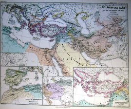
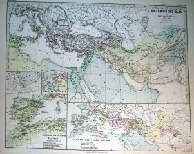
Die lander des Islam zur Zeit der Bujiden 945-1055 / Arabien / Grazneviden / Ostromisches Reich.
Published by Gotha, 1877
Art / Print / Poster
Condition: ACEPTABLE. Atlas Spruner-Menke, 1880 Gotha : Justus Perthes. 1877 Incluye peque�o mapa de Espa�a Formato (cm): 46x38.
-
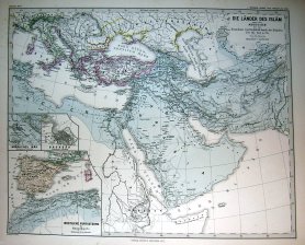
Die Lander des Islam unter den Abbasiden.750 bis 945 n. Ch / Nordliches Irak / Baghdad.
Published by Gotha, 1877
Art / Print / Poster
Condition: ACEPTABLE. Atlas Spruner-Menke, 1880 Gotha : Justus Perthes. 1877 Incluye peque�o mapa de Espa�a Formato (cm): 46x38.
-
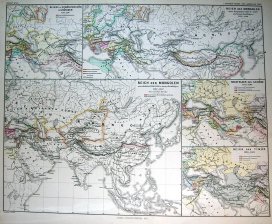
Reich der Mongolen / Nachfolger der Ilkhane / Reich des Timur
Published by Gotha, 1877
Art / Print / Poster
Condition: ACEPTABLE. Atlas Spruner-Menke, 1880 Gotha : Justus Perthes. 1877 Formato (cm): 46x38.
-
Condition: ACEPTABLE. Atlas Spruner-Menke, 1880 Gotha : Justus Perthes. 1876 Formato (cm): 46x38.
-
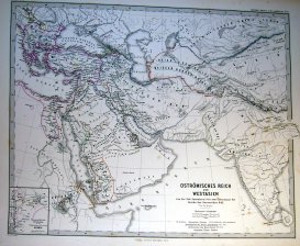
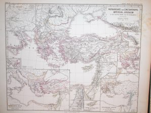
Ostromisches Reich und Westasien von der Zeit Justinians.642
Published by Gotha, 1871
Art / Print / Poster
Condition: ACEPTABLE. Atlas Spruner-Menke, 1880 Gotha : Justus Perthes. 1871 Formato (cm): 46x38.
-

Lateinische Herrschaften im Orient 1219 bis 1311 / Achaia / Constantinopel / Tyrus.
Published by Gotha, 1876
Art / Print / Poster
Condition: ACEPTABLE. Atlas Spruner-Menke, 1880 Gotha : Justus Perthes. 1876 Formato (cm): 46x38.
-
Die Lander des Islam zur Zeit der Selguken 1055-1163 / Edessa .
Published by Gotha, 1877
Art / Print / Poster
Condition: ACEPTABLE. Atlas Spruner-Menke, 1880 Gotha : Justus Perthes. 1877 Incluye peque�o mapa de Espa�a Formato (cm): 46x38.


![Seller image for [ATLAS] SPRUNER-MENKE HAND-ATLAS FUR DIE GESCHICHTE DES MITTELALTERS UND DER NEUREN ZEIT DRITTE AUFLAGE for sale by BLACK SWAN BOOKS, INC., ABAA, ILAB](https://pictures.abebooks.com/inventory/md/md31703818409.jpg)


