Nicholas Fer (20 results)
Published by Paris: Nicolas de Fer, circa 1693., 1693
- Hardcover
- Art Print
Seller: Wittenborn Art Books, San Francisco, CA, U.S.A.Wittenborn Art Books
Contact seller5-star sellerCondition: Used - Good
US$ 1,250.00
US$ 10.00 shippingShips within U.S.A.Quantity: 1 available
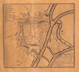
Condition: Good. 4to. 23 x 29cm. 18th Century rose cardboard covers. 33 engraved views and plans and 2 hand-drawn plans of Versoi and the col of Grand-Saint-Bernard showing Saint-Rhémy et San Leonardo. Old manuscript table of contents. Most of the plates are 17th Century but 2 are 18th Century. Small losses and browning to most…plates.Nicholas de Fer (1646 - 1720) was the son of cartographer Antoine de Fer. Nicholas was established as an engraver, cartographer, and map publisher in Paris, with over 600 maps and atlases to his credit. His work earned a large following because of its considerable decorative appeal. In the late 17th century, de Fer's career culminated in his appointment as Geographer to the King of France. Upon his death in 1720, Nicolas was succeeded by two of his sons-in-law, Guillaume Danet and Jacques-François Danet and their heirs, who continued the de Fer publishing firm until c. 1760. Recueil de 35 cartes, plans et vues de villes fortifiées, gravées sur cuivre (33) et manuscrites (2). S.l.n.d. [Paris, 1693 e.a.]. In-4 oblong, cartonnage rose, pièce de titre manuscrite (Reliure vers 1800).Le présent ensemble contient :- 27 cartes et plans de villes fortifiées, extraites pour la plupart de l'atlas de Nicolas de Fer (1693), montrant Turin, Endingen, Mont Royal, Mayence, Ath, Pignerol, Mont-Melian, Landau, Casal, Verceil, Genève, Maestricht, Huningue, Nice, Charle-Roy, Bonn, Calais, Coblentz, Stetin, Juliers, Wismar, Mons, Verüe, Berg S. Winox, Kamieniec Podolski, Donquerque, Coni ;- 4 vues gravées de Montmélian, Miolans, Verue (Verrua Savoia) et du siège de Genève ;- 2 planches manuscrites : un plan de Versoi et une carte du col du Grand-Saint-Bernard montrant Saint-Rhémy et San Leonardo ;- 2 petites planches gravées postérieures.Exemplaire défraîchi : cartes jaunies présentant parfois des restaurations ; petits manques marginaux à quelques cartes, quelques rousseurs et taches d'encre.
Published by Sterling Publishing House, Co., Inc, New York, 1960
- First Edition
Seller: Between the Covers-Rare Books, Inc. ABAA, Gloucester City, NJ, U.S.A.Between the Covers-Rare Books, Inc. ABAA
Contact seller5-star sellerCondition: Used - Very good
US$ 100.00
US$ 5.50 shippingShips within U.S.A.Quantity: 1 available
Unbound. Condition: Very Good. Portfolio. Color facsimiles of 36 historical maps. Each map measures approximately 12" x 9", printed on 17" x 11½" paper with descriptive text in the left margin. Housed with a title page sheet and unprinted top sheet in a four-fold chemise. Unprinted topsheet sunned at the edges, first two leaves…with some very light toning and a couple of tiny corner creases; the maps are otherwise bright and fine. The chemise is good only with toning, wear, and soil, and a 1" creased tear on the cover panel. A nice production, and the chemise has done its job, keeping the maps bright and fresh.

Published by A Paris: Chez l'autheur., [1706?]., 1706
- Map
Seller: Spike Hughes Rare Books ABA, Innerleithen, United KingdomSpike Hughes Rare Books ABA
Contact seller5-star sellerCondition: Used
US$ 75.64
US$ 38.72 shippingShips from United Kingdom to U.S.A.Quantity: 1 available
Engraved map of Scotland, image size 370 X 515 mm., some faint hand-colouring, mounted on card, some foxing and browning to blank margins. No actual title but with 'Table' printed top right. Due to being mounted on card this will not fold for posting but would need to be sent flat. Overall size is 460 X 590 mm.

Published by Paris, 1693
Seller: Chapter 1, Johannesburg, GAU, South AfricaChapter 1
Contact seller5-star sellerCondition: Used - Good
US$ 100.00
US$ 28.60 shippingShips from South Africa to U.S.A.Quantity: 1 available
No Binding. Condition: Good. copper-plate print. uncoloured. fortification and Church jutting into mediterranean. cartouche with cherub like individuals and a sheep. Our orders are shipped using tracked courier delivery services.

Published by Paris. 1717, 1717
Seller: Peter Harrington. ABA/ ILAB., London, United KingdomPeter Harrington. ABA/ ILAB.
Contact seller5-star sellerCondition: Used
US$ 130.65
US$ 29.37 shippingShips from United Kingdom to U.S.A.Quantity: 1 available
Detailed map of a battle in the July of 1712, with troop placementsand positions on the map. An explanation of the battle at lower right. Accompanying text on reverse. Published in de Fer's Atlas Curieux ou Le Monde. Copper engraving. Very good condition. Upper left, top and right hand margin have been trimmed close to edge of p…late Later colouring. Size: 52.5 x 31 cm.
Published by s.i., [c. 1694]., S.l.,, 1694
Seller: Llibreria Antiquària Delstres, Canet de Mar, B, SpainLlibreria Antiquària Delstres
Contact seller4-star sellerCondition: Used
US$ 106.04
US$ 54.91 shippingShips from Spain to U.S.A.Quantity: 1 available
Procede de la obra, Les Forces de L`Europe, Asie, Afrique et Amerique ou description des principales villes avec leurs fortifications Nicholas de Fer (1646 1720). Grabado en una hoja de papel verjurado. Ligero roto en la parte superior que afecta muy ligeramente al grabado, por lo general en buen estado. 22x33 cm.
 More images
Vintage Map of the Middle East: "Turquieen Asie" [showing the Aegean Sea, The Black Sea with Georgia in the very North of the Map and the showing the whole of Turkey, Cyprus, Armenia ("Turcomanie Armenie"], continuing south to Syria and Lebanon with Palestine ("Terres Judee") and showing parts of Persia to the east and all the way south to Medina - With a corresponding map [along the "Tropic of Cancer"] mounted verso: "Asie" [Showing the whole of Asia from the Mediterranean to Japan with Borneo, Phillipines etc.]
Middle East - Fer, Nicholas de / [Nicolas de Fer]. (1646 - 1720)
Published by [Paris], c. 1700, 1700
- Art Print
Seller: Inanna Rare Books Ltd., Skibbereen, CORK, IrelandInanna Rare Books Ltd.
Contact seller5-star sellerCondition: Used - As new
US$ 259.21
US$ 32.03 shippingShips from Ireland to U.S.A.Quantity: 1 available
Condition: Wie neu. Original copper engraved maps. 15.5 cm wide x 13 cm high. Mounted on paper. Very good condition. From a wonderful collection of Maps from an old english library (South Shields) - with a tiny library stamp to the mounting paper (The stamp is NOT on the Map). Nicolas de Fer (164625 October 1720) was a French ca…rtographer and geographer. De Fer was the youngest of three sons of Antoine de Fer, who was also a cartographer. When he was 12, he became the apprentice of Parisian engraver Louis Spirinx, and made his first map, of the Canal du Midi, at the age of 23. After the death of his father in June 1673, his mother Geneviève initially took over the map making company, which had begun to decline. She passed it and the atelier, called Quai de L'Horloge, on to Nicolas in 1687 because of her old age. De Fer was so successful at improving the firm that, in 1690, he became the official geographer to Louis, Dauphin of France. With support from the Spanish and French Royal Families, de Fer also became official geographer for Philip V and Louis XIV, the kings of Spain and France, respectively. Because of this, his maps became Bourbon propaganda, endorsing French King Louis XIV. His business flourished, producing town plans, atlases, wall maps, and more than 600 sheet maps. He made maps of places in Europe and North America, including New Spain, places fortified by Vauban, the Low Countries, and the War of the Spanish Succession. In 1698, de Fer published a map of North America, which included a depiction of beavers building dams near Niagara Falls. Seventeen years later, Herman Moll published a map which plagiarized elements of de Fer's work, particularly the beaver scene. It became known as the "Beaver map". De Fer became the official geographer for His Catholic Majesty in 1720. Two of his sons-in-law, Guillaume Danet and Jaques-François Bénard, continued the company after de Fer's death on 25 October of that year until around 1760. (Wikipedia).

Grande Tartarie [Central Asia] with Cazan [Kazan], Turquestan, Mer Caspiene, Usbeck, Cercle Polaire Actiq, Aux Moscovites, etc.
Tartary - Fer, Nicholas de / [Nicolas de Fer]. (1646 - 1720)
Published by [Paris], c. 1700, 1700
- Art Print
Seller: Inanna Rare Books Ltd., Skibbereen, CORK, IrelandInanna Rare Books Ltd.
Contact seller5-star sellerCondition: Used - As new
US$ 259.21
US$ 32.03 shippingShips from Ireland to U.S.A.Quantity: 1 available
Condition: Wie neu. Original copper engraved map. 16 cm wide x 13.2 cm high. Mounted on paper. Very good condition. From a wonderful collection of Maps from an old english library (South Shields) - with a tiny library stamp to the mounting paper (The stamp is NOT on the Map). Nicolas de Fer (164625 October 1720) was a French car…tographer and geographer. De Fer was the youngest of three sons of Antoine de Fer, who was also a cartographer. When he was 12, he became the apprentice of Parisian engraver Louis Spirinx, and made his first map, of the Canal du Midi, at the age of 23. After the death of his father in June 1673, his mother Geneviève initially took over the map making company, which had begun to decline. She passed it and the atelier, called Quai de L'Horloge, on to Nicolas in 1687 because of her old age. De Fer was so successful at improving the firm that, in 1690, he became the official geographer to Louis, Dauphin of France. With support from the Spanish and French Royal Families, de Fer also became official geographer for Philip V and Louis XIV, the kings of Spain and France, respectively. Because of this, his maps became Bourbon propaganda, endorsing French King Louis XIV. His business flourished, producing town plans, atlases, wall maps, and more than 600 sheet maps. He made maps of places in Europe and North America, including New Spain, places fortified by Vauban, the Low Countries, and the War of the Spanish Succession. In 1698, de Fer published a map of North America, which included a depiction of beavers building dams near Niagara Falls. Seventeen years later, Herman Moll published a map which plagiarized elements of de Fer's work, particularly the beaver scene. It became known as the "Beaver map". De Fer became the official geographer for His Catholic Majesty in 1720. Two of his sons-in-law, Guillaume Danet and Jaques-François Bénard, continued the company after de Fer's death on 25 October of that year until around 1760. (Wikipedia).
 More images
Vintage Maps of Cambodia, Ceylon and Maledives with India: "Presqu' Isle de L'Indedela le Golfe du Gange" AND Presqu' Isle de L'Inde de la le Golfe du Gange" [with Golf de Siam , Bankok etc.] / With an additional map mounted verso: "Amerique Meridionale" [showing Central America and South America from Isles de Caribes to the "Detroit de Magellan"]
Cambodia - Fer, Nicholas de / [Nicolas de Fer]. (1646 - 1720)
Published by [Paris], c. 1700, 1700
- Art Print
Seller: Inanna Rare Books Ltd., Skibbereen, CORK, IrelandInanna Rare Books Ltd.
Contact seller5-star sellerCondition: Used - As new
US$ 259.21
US$ 32.03 shippingShips from Ireland to U.S.A.Quantity: 1 available
Condition: Wie neu. Original copper engraved maps. 16 cm wide x 13.2 cm high. Mounted on paper. Very good condition. From a wonderful collection of Maps from an old english library (South Shields) - with a tiny library stamp to the mounting paper (The stamp is NOT on the Map). Nicolas de Fer (164625 October 1720) was a French ca…rtographer and geographer. De Fer was the youngest of three sons of Antoine de Fer, who was also a cartographer. When he was 12, he became the apprentice of Parisian engraver Louis Spirinx, and made his first map, of the Canal du Midi, at the age of 23. After the death of his father in June 1673, his mother Geneviève initially took over the map making company, which had begun to decline. She passed it and the atelier, called Quai de L'Horloge, on to Nicolas in 1687 because of her old age. De Fer was so successful at improving the firm that, in 1690, he became the official geographer to Louis, Dauphin of France. With support from the Spanish and French Royal Families, de Fer also became official geographer for Philip V and Louis XIV, the kings of Spain and France, respectively. Because of this, his maps became Bourbon propaganda, endorsing French King Louis XIV. His business flourished, producing town plans, atlases, wall maps, and more than 600 sheet maps. He made maps of places in Europe and North America, including New Spain, places fortified by Vauban, the Low Countries, and the War of the Spanish Succession. In 1698, de Fer published a map of North America, which included a depiction of beavers building dams near Niagara Falls. Seventeen years later, Herman Moll published a map which plagiarized elements of de Fer's work, particularly the beaver scene. It became known as the "Beaver map". De Fer became the official geographer for His Catholic Majesty in 1720. Two of his sons-in-law, Guillaume Danet and Jaques-François Bénard, continued the company after de Fer's death on 25 October of that year until around 1760. (Wikipedia).

Vintage Map of Iran / Persia: "Perse" [showing the whole of Iran from the Caspian Sea to the Gulf of Basra (Golfe de Balsora) / Persian Gulf]
Middle East - Fer, Nicholas de / [Nicolas de Fer]. (1646 - 1720)
Published by [Paris], c. 1700, 1700
- Art Print
Seller: Inanna Rare Books Ltd., Skibbereen, CORK, IrelandInanna Rare Books Ltd.
Contact seller5-star sellerCondition: Used - As new
US$ 259.21
US$ 32.03 shippingShips from Ireland to U.S.A.Quantity: 1 available
Condition: Wie neu. Original copper engraved maps. 15.5 cm wide x 13 cm high. Mounted on paper. Very good condition. From a wonderful collection of Maps from an old english library (South Shields) - with a tiny library stamp to the mounting paper (The stamp is NOT on the Map). Nicolas de Fer (164625 October 1720) was a French ca…rtographer and geographer. De Fer was the youngest of three sons of Antoine de Fer, who was also a cartographer. When he was 12, he became the apprentice of Parisian engraver Louis Spirinx, and made his first map, of the Canal du Midi, at the age of 23. After the death of his father in June 1673, his mother Geneviève initially took over the map making company, which had begun to decline. She passed it and the atelier, called Quai de L'Horloge, on to Nicolas in 1687 because of her old age. De Fer was so successful at improving the firm that, in 1690, he became the official geographer to Louis, Dauphin of France. With support from the Spanish and French Royal Families, de Fer also became official geographer for Philip V and Louis XIV, the kings of Spain and France, respectively. Because of this, his maps became Bourbon propaganda, endorsing French King Louis XIV. His business flourished, producing town plans, atlases, wall maps, and more than 600 sheet maps. He made maps of places in Europe and North America, including New Spain, places fortified by Vauban, the Low Countries, and the War of the Spanish Succession. In 1698, de Fer published a map of North America, which included a depiction of beavers building dams near Niagara Falls. Seventeen years later, Herman Moll published a map which plagiarized elements of de Fer's work, particularly the beaver scene. It became known as the "Beaver map". De Fer became the official geographer for His Catholic Majesty in 1720. Two of his sons-in-law, Guillaume Danet and Jaques-François Bénard, continued the company after de Fer's death on 25 October of that year until around 1760. (Wikipedia).

Published by Auteur, Paris, 1701
- Art Print
Seller: LIBRERÍA MAESTRO GOZALBO, Carcaixent, V, SpainLIBRERÍA MAESTRO GOZALBO
Contact seller5-star sellerCondition: Used - Very good
US$ 1,796.79
US$ 57.20 shippingShips from Spain to U.S.A.Quantity: 1 available
Condition: Buen estado. 1 lámina sin enmarcar Buen estado Nicholas de Fer (1646 - 1720) aprendiz de Louis Spirinx . Familia de grabadores con establecimiento en Quai de l'Horloge (Paris). Realizo más de 600 mapas y atlas. El artículo se compone de dos grabados pegados.

Published by Paris:, 1722
Seller: Nicholas D. Riccio Rare Books, ABAA, Florham Park, NJ, U.S.A.Nicholas D. Riccio Rare Books, ABAA
Contact seller4-star sellerEngraved double page map, 28" x 20", wide margins, hand colored in outline, two uncolored pictorial cartouches. Expert and nearly invisible repairs along centerfold, normal aging; about near fine. Impression is bright and clean. Nicholas De Fer (1646-1720) was a highly respected and prolific French cartographer whose maps were v…alued for their decorative appeal. Around 1690 he was made the geographer to the Dauphin, and published his first atlas. He would become geographer to other high-ranking individuals in French and Spanish society. The present map is detailed and attractive map of Asia, with a cartouche showing Chinese at the upper left, and Indians in the upper right. The map covers a lot of territory showing Arabia and the Persian Empire in the West, and Japan in the east, but goes as far south as the Isle of Borneo and Java. Part of Eastern Europe is also visible. Library missouri website.
 More images
Published by Nicolas De Fer, Paris, 1701
- First Edition
Seller: Kuenzig Books ( ABAA / ILAB ), Topsfield, MA, U.S.A.Kuenzig Books ( ABAA / ILAB )
Contact seller5-star sellerCondition: Used - Very good
US$ 875.00
US$ 5.99 shippingShips within U.S.A.Quantity: 1 available
Condition: Very Good. First Edition. Ginville, Vincent de. First Edition. Paper size 42.5 cm x 28.5 cm. Plate mark 34 x 22.5 cm. Marginal paper clip stain, inked '109' upper right corner, some marginal chipping to the paper, and old penciled price lower right. A few unobtrusive spots inside the plate marks. Copperplate engraving… by Vincent de Ginville with later (awfully bright) hand color. This map would frame up nicely. There appears to be several versions of this map. The David Rumsey Collection has an example dated (on the cartouch) 1705 which he notes as being from Nicolas De Fer's Atlas Curieux, published later. The Library of Congress has an example of the map offered here, with the 1701 date, and a separate page with explanations of the map. We don't know where this 1701 example came from (separately issued or another atlas?). The map highlights locations of Indian villages found by La Salle during his explorations of the coastal areas of the United States. We see the Gulf of Mexico, Cap de la Floride and many inland village names. A nice map showing some early history of the southern United States. It includes parts of modern-day Louisiana, Mississippi, Alabama, and Florida, as well as the Bahamas and Cuba. Ginville, Vincent de (illustrator).
Language: French
- Map
Seller: Antiquariat Renner OHG, Albstadt, GermanyAntiquariat Renner OHG
Contact seller5-star sellerAssociation member: BOEV
Condition: Used - Very good
US$ 117.82
US$ 51.48 shippingShips from Germany to U.S.A.Quantity: 1 available
Kein Einband. Condition: Gut. Unkolorierter Kupferstich 27,5 x 19 cm. Gestochen von H. van Loon. Blattgröße 38 x 28,5 cm. Stadtplan von Charleroi, Belgien.- Links oben Kartusche "A Paris. Chez l'Autheur Isle du Palais fur le quay de l'Or loge a la Sphere Royale avec Privilege du Roy: 1693. Mit Maßstab. Unten links 11zeiliger fra…nzösischer Text. Rechts Kompass "Nort" zeigt nach rechts.- Die Karte ist gering gebräunt, die Ränder leicht fleckig, das Kartenbild ist sauber. Der linke Rand ist gering beschädigt am oberen und unteren Rand jeweils ein kleiner Einriß (ca. 2 cm), die Karte ist nicht betroffen. Einmal in der Mitte gefaltet.
Seller: Herman H. J. Lynge & Søn ILAB-ABF, Copenhagen, DenmarkHerman H. J. Lynge & Søn ILAB-ABF
Contact seller4-star sellerCondition: Used
US$ 157.56
US$ 48.04 shippingShips from Denmark to U.S.A.Quantity: 1 available
(Paris, ca. 1695). 23x29,5 cm. Kobberstukket kort i fugleperspektiv over Göteborg og den nordlige del af sundet med byplan og fortifikationer. Med stor kartouche. Håndkoloreret. Fra Nicholas de Fer: "Les Forces d l'Europe".

- Map
Seller: Geographicus Rare Antique Maps, Brooklyn, NY, U.S.A.Geographicus Rare Antique Maps
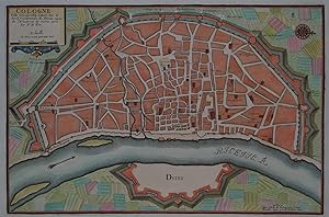
Contact seller4-star sellerVery good. Original platemark visible. Blank on verso. Minor overall toning. Size 9.5 x 14 Inches. This is a beautiful 1705 Nicholas de Fer map of the walled city of Cologne, Germany. Oriented with North to the right, this map identifies the location of the city on the banks of the Rhine River. Originally the capital city of the… Roman province Germania Inferior, Cologne was established in 50 AD. The medieval city wall surrounding the city was built in 1180 and enclosed the Free Imperial City for 600 years. Of the original 12 city gates, only Eigelsteintorburg, Hahnentorburg, Severinstorburg and Ulrepforte remain to this day. The remains of Bayen, the medieval tower and the city wall at Gereonswall can also been seen today. This map identifies various streets, churches and other notes other topographical details throughout. This map created by Nicholas de Fer in 1705.

- Map
Seller: Antique Paper Company, ASHFORD, KENT, United KingdomAntique Paper Company
Contact seller2-star sellerCondition: Used
US$ 378.20
US$ 8.01 shippingShips from United Kingdom to U.S.A.Quantity: 1 available
1705 PLAN DE LA VILLE DE ROME Par de Fer. A PARIS.Detailed city plan of Rome, both numbered and lettered keys locating significant buildings of the city. The layout of the map closely resembles the map by Joan Blaeu first issued in 1663. However due to its smaller size, the specific houses of the city are laid out in blocks with… only important public buildings and churches individually depicted. These are keyed to a list on the lower part of the map. Overall size approx 36.8cm x 27.3cm. Condition is generally good with some light age toning around the outer margins.Nicolas de Fer was an extremely ambitious and highly successful map maker and publisher in the late 17th and early 18th century. He was born in Paris in 1646 and in 1687, he inherited his fathers publishing firm. By 1690, he was named Cartographer to the Dauphin of France and would go on to became Cartographer to Louis XIV and Philip V of Spain. These appointments gave him extraordinary access to source maps not normally available to his contemporaries. Despite this access, his maps were not always the most accurate although he also suffered by comparison to his contemporary Guillaume de LIsle, who was named the the first scientific cartographer. Confusingly, de LIsle was named Premier Geographe du Roy a different yet complementary position to the Geographe du Roy given to de Fer.Despite these criticisms, de Fer was extremely successful with his output being prodigious and enormously varied: he published wall maps, miniatures, geographies as well as atlases. One of his more esoteric publications is a volume of European city plans based on the fortification designs of the important military engineer Sebastian Vauban, who revolutionised city fortifications in the late 17th and early 18th century.One of his flagship products was the Atlas Curieux issued between 1700 and 1705. This was a general atlas of a more accessible nature and smaller size than usual folio maps. It covered the whole world and also included many city plans as well as several panoramic views and even garden plans, particularly Versailles.
 More images
Language: German
- Art Print
Seller: Kunstantiquariat Andreas Senger, Hamburg, GermanyKunstantiquariat Andreas Senger
Contact seller5-star sellerCondition: Used - Fine
US$ 210.90
US$ 40.04 shippingShips from Germany to U.S.A.Quantity: 1 available
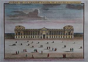
Kein Einband. Condition: Sehr gut. Es handelt sich hierbei um einen seltenen, originalen, kolorierten Kupferstich des Palais du Louvre von de Fer aus dem Jahr 1700. *** Titel: Veue de la grande fasade du Louvre, du côte d'Orient *** Gebiet bzw. Ort: Palais du Louvre, Paris *** Kartograph: Nicholas de Fer (1647 - 1720) *** Jahr:…um 1700 *** Größe des Plattenbereichs: ca. 24 cm x 32 cm *** Technik: Kupferstich *** Zustand (Perfekt/ Sehr gut/ Gut/ Ordentlich/ Mäßig/ Schlecht): In sehr gutem Erhaltungszustand *** Bemerkungen: Sehr seltene und Ansicht des Palais du Louvre mit Personenstaffage im Vordergrund. Ein dazugehörender, beschreibender Kupferstich liegt ebenfalls bei. Der Louvre-Palast (französisch Palais du Louvre, kurz Louvre) ist die frühere Residenz der französischen Könige in Paris. Er bildete zusammen mit dem zerstörten Palais des Tuileries das Pariser Stadtschloss. Die Herkunft des Namens Louvre ist unklar; zahlreiche Deutungen konkurrieren miteinander. Der Louvre-Palast beherbergt heute größtenteils das nach ihm benannte Musée du Louvre, das zumeist einfach Louvre genannt wird. Mit etwa zehn Millionen Besuchern im Jahr 2012 ist es das meistbesuchte Museum der Welt. Daneben birgt der Nordflügel drei Museen (Musée des Arts décoratifs, Musée de la Mode et du Textile, Musée de la Publicité) und der Bibliothèque des Arts décoratifs. (Wikipedia) *** English description: This a rare, original copper engraving, published by Nicholas de Fer (1647 - 1720) around 1700 in Paris. It shows the Palais du Louvre in Paris which was the former main part of the city palace of the French Kings. Today it contains the famous Louvre art museum. The engraving measures ca. 24 x 32 cm (platesize) and is in very good condition. Included is a further engraving which contains a description in French. - - - International buyers welcome. If you have any questions, please don't hesitate to ask. --- Auf Wunsch stellen wir Ihnen gerne ein kostenfreies Echtheitszertifikat aus --- If you wish, we will gladly provide a certificate of authenticity free of charge ---.
 More images
Language: German
- Art Print
Seller: Kunstantiquariat Andreas Senger, Hamburg, GermanyKunstantiquariat Andreas Senger
Contact seller5-star sellerCondition: Used - Fine
US$ 293.38
US$ 40.04 shippingShips from Germany to U.S.A.Quantity: 1 available
Kein Einband. Condition: Sehr gut. Es handelt sich hierbei um einen originalen, kolorierten Kupferstichplan der Stadt Köln von Nicholas de Fer aus dem Jahr 1702. *** Titel: Cologne Ville Considerable Situee sur le bord Occidentale du Rhein Capit. de l'Electorat de meme nom. Par N. de Fer *** Gebiet bzw. Ort: Köln *** Kartograph:… Nicholas de Fer (1647 - 1720) *** Jahr: 1702 *** Größe des Abbildungsbereichs: 23 x 35 cm *** Technik: Kupferstich *** Zustand (Perfekt/ Sehr gut/ Gut/ Ordentlich/ Mäßig/ Schlecht): In sehr gutem Erhaltungszustand *** Bemerkungen: Schöner Plan von Köln aus der Vogelschau in dekorativem Kolorit. - - - International buyers welcome. If you have any questions, please don't hesitate to ask. --- Auf Wunsch stellen wir Ihnen gerne ein kostenfreies Echtheitszertifikat aus --- If you wish, we will gladly provide a certificate of authenticity free of charge ---.
 More images
Language: German
- Art Print
Seller: Kunstantiquariat Andreas Senger, Hamburg, GermanyKunstantiquariat Andreas Senger
Contact seller5-star sellerCondition: Used - Very good
US$ 352.29
US$ 40.04 shippingShips from Germany to U.S.A.Quantity: 1 available
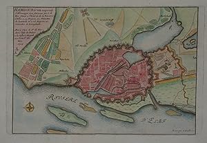
Kein Einband. Condition: Gut. Es handelt sich hierbei um einen originalen, kolorierten Kupferstichplan der Stadt Hamburg von Nicholas de Fer aus dem Jahr 1705. *** Titel: Hambourg Ville Imperiale d' Allemagne tres *** Gebiet bzw. Ort: Hansestadt Hamburg +++ Kartograph: Nicholas de Fer (1647 - 1720) *** Jahr: 1705 *** Größe des A…bbildungsbereichs: 19 x 28 cm *** Technik: Kupferstich *** Zustand (Perfekt/ Sehr gut/ Gut/ Ordentlich/ Mäßig/ Schlecht): In gutem Erhaltungszustand. Altersgemäß leicht gebräunt. *** Bemerkungen: Schöner Plan von Hamburg in dekorativem Kolorit. Detaillierter Grundriss der Stadt Hamburg mit ihren Befestigungen, Hafenanlagen, der Binnen- und Außenalter. - - - International buyers welcome. If you have any questions, please don't hesitate to ask. --- Auf Wunsch stellen wir Ihnen gerne ein kostenfreies Echtheitszertifikat aus --- If you wish, we will gladly provide a certificate of authenticity free of charge ---.


