
Order Total (1 Item Items):
Shipping Destination:

Old Map (28 results)
Author:
old map
Refine with Advanced Search
Skip to main search results
Search filters
Product Type
- All Product Types
- Books (19)
- Magazines & Periodicals (1)
- Comics (No further results match this refinement)
- Sheet Music (No further results match this refinement)
- Art, Prints & Posters (No further results match this refinement)
- Photographs (No further results match this refinement)
- Maps (8)
- Manuscripts & Paper Collectibles (No further results match this refinement)
Condition Learn more
- New (1)
- As New, Fine or Near Fine (2)
- Very Good or Good (14)
- Fair or Poor (No further results match this refinement)
- As Described (11)
Binding
Collectible Attributes
Language (2)
Free Shipping
Seller Location
Seller Rating
-

Hard cover. Condition: Very good. No dust jacket. map (illustrator). First edition. 290 p. 22 cm. clean and tight.
-
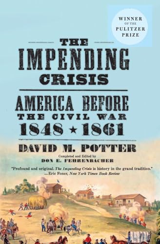
IMPENDING CRISIS, 1848-1861.AMERICA BEFORE THE CIVIL WAR.; NEW AMERICAN NATION SERIES
Language: English
Published by Harper Perennial, NY, 1976
ISBN 10: 0061319295 ISBN 13: 9780061319297
First Edition
paperback. Condition: Very Good. Illustrated by Old Photo & ilust section mid book & MAP (illustrator). VERY GOOD CONDITION , CLEAN, SOLID, BRIGHT .Text pages white. 1" COVER GOLD CIRCLE 'WINNER OF THE PULITZER PRIZE" ; Black titles on LITE blue PAPER covers.WRAPAROUND COVER shows IMMIGRATION, WARFARE & RUSTIC SCENES.lite blue spine strip. ; 672 pages; sweeping epic masterfully charts the chaotic forces that climaxed with the outbreak of the Civil War: westward expansion, the divisive issue of slavery, the Dred Scott decision, John Brown's uprising, the ascension of Abraham Lincoln, and the drama of Southern secession. Indexed . First Edition Thus; Forty-Ninth Printing.
-

WHEN THE RIVERS RAN RED: AN AMAZING STORY OF COURAGE AND TRIUMPH IN AMERICA'S WINE COUNTRY
Language: English
Published by Palgrave MacMillan, NY, 2009
ISBN 10: 0230605745 ISBN 13: 9780230605749
Hardcover. Condition: Very Good. Dust Jacket Condition: Very Good. Illustrated by MAP, OLD PHOTOS (illustrator). FIRST PUBLISHED". VERY GOOD CONDITION IN VERY GOOD UNCLIPT(NOPR ICE) DUST JACKET.CLEAN, SOLID, BRIGHT VERY NICE DJ ; Silver spine titles on matte black hard covers.white endpapers.Attractive wraparound dj art color photo shows rolling green vine lands in misty haze.a taste full book.Family business biougraphies of early & PROHIBITION Years. ; 256 pages; When Prohibition took effect in 1919, three months after one of the greatest California grape harvests of all time, violence and chaos descended on Northern California. Federal agents spilled thousands of gallons of wine in the rivers and creeks, gun battles erupted on dark country roads, and local law enforcement officers, sympathetic to their winemaking neighbors, found ways to run circles around the intruding authorities.
-
The Taxonomy and Distribution of the Boring Sponges (Clionidae) Along the Atlantic Coast of North America
Published by Chesapeake Biological Laboratory, Solomons Island, MD, 1941
Seller: Clausen Books, RMABA, Colorado Springs, CO, U.S.A.
Association Member: IOBA RMABA
Seller rating 5 out of 5 stars

Stapled Wraps. Condition: Very Good. B&W Photographs & Drawings; One Folded Map (illustrator). Text block clean and tight with light soiling to cover. 30 pp. 8vo - over 7�" - 9�" tall. Paperback.
-
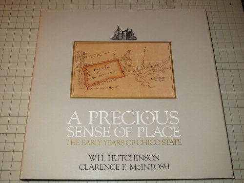
PRECIOUS SENSE OF PLACE, THE EARLY YEARS OF CHIDO STATE
Language: English
Published by Fiends of Meriam Libray pub SCUC, CHICO,CA, 1982
ISBN 10: 0962851906 ISBN 13: 9780962851902
First Edition
Paperback. Condition: Very Good. Dust Jacket Condition: Very Good. Illustrated by Many Nice Old Photos. MAP OF CHICO (illustrator). First Edition. VERY GOOD CONDITION IN VERY GOOD UNCLIPT(NP PR ICE) DUST JACKET,CLEAN, SOLID, BRIGHT; GOLD SPINE & COVER TITLES ON BLACK CLOTH HARD COVERS. CLEAN,SOLID,BRIGHT GOLD COVER TITLES.DUST JACKET SHOWS 4X6" map of Rancho Arroyo Chico on grey paper ; 108pg pages; History of JOHN BIDWELL AND STATE NORMAL SCHOOL'S early formative years that have led it into becoming the major regional university. ATTRACTIVE BLACK ENDPAPERS.; calif hutch.
-
Vacationists Directory To The Central Adirondacks
Seller: Terrace Horticultural Books, St. Paul, MN, U.S.A.
Seller rating 3 out of 5 stars

StapleBound. Condition: very good. Green Tint Photo, Map (illustrator). Narrow 12mo, No Date, Ca 1950, PP.18, Hotels, Cottages, Camps, Restaraunts, Services, TRansportation, Stables etc.Along Route 28, The Adirondack Lakes Trais.
-
WHEN CHICO STOLE THE COLLEGE
Published by BUTTE SAVINGS & LOAN ASSOC 1982,1983, CHICO,CA;QUADCO Printing, 1982
First Edition
Paperback. Condition: Very Good. Illustrated by Photos,Drawings,MAP (1850) (illustrator). First Edition?. ,VERY GOOD Condition,CLEAN, SOLID, BRIGHT; PAPERBACK.DOUBLE STAPLED,BROWN STIFFF PAPER COVERS.CLEAN,SOLID,BRIGHT GOLD COVER TITLES. TITLE PAGE HAS CLEAR OLD PHOTO OF ORIGINAL 3 STORY BRICK COLLEGE BUILDING. (page 2 states c1982. but page 1983 states "Compliments of Direcotrs .Butte Savings etc 1983". ; 23pg thin pages; History of JOHN BIDWELL; RAILROAD, LUMBERING; DIAMOND MATCH COMPANY;CHICO MUNICIPLE AIRPORT;STATE NORMAL SCHOOL. clean,solid copy.; calif hutch.
-
WHEN CHICO STOLE THE COLLEGE
Published by BUTTE SAVINGS & LOAN ASSOC, CHICO,CA;QUADCO Printing, 1982
First Edition
Paperback. Condition: Very Good. Illustrated by Photos,Drawings,MAP (1850) (illustrator). First Edition?. ,VERY GOOD Condition,CLEAN, SOLID, BRIGHT; PAPERBACK.DOUBLE STAPLED,BROWN STIFFF PAPER COVERS.CLEAN,SOLID,BRIGHT GOLD COVER TITLES. TITLE PAGE HAS CLEAR OLD PHOTO OF ORIGINAL 3 STORY BRICK COLLEGE BUILDING.; 23pg thin pages; History of JOHN BIDWELL; RAILROAD, LUMBERING; DIAMOND MATCH COMPANY;CHICO MUNICIPLE AIRPORT;STATE NORMAL SCHOOL. clean,solid copy.; calif hutch.
-
Old Ordnance Survey Maps Trafford Park 1905 Lancashire Sheet 103.12
Published by Alan Godfrey Maps, Consett, 1111
Seller: Castle Hill Books, Llandrindod Wells, United Kingdom
Seller rating 4 out of 5 stars

Paperback. Condition: Fine. Lancashire Sheet 103.12 reprint of Ordnance Survey map of 1905 with description of area on rear and details of area from directory of same date; Octavo.
-

Florida's Centennial Library of Congress An Adress By the Hon. Claude Pepper, Senator from Florida, on the Occasion of Ceremonies Opening the Florida Centennial Exhibition at the Library of Congress Together with a Catalog of the Exhibition
Language: English
Published by Government Printing Office, Washington, D.C., 1946
Seller: Dorley House Books, Inc., Hagerstown, MD, U.S.A.
Seller rating 4 out of 5 stars
First Edition
Paperback. Condition: Very Good. b/w illus w/old-out facsimile map of Florida. (illustrator). 1st Edition. stapled pictorial wraps; lite rubbig of edges; 36 clean, unmarked pages.
-

HISTORY OF SARGENT COUNTY, VOLUME 2 (VOL TWO II) 1880-1920: Forman, Gwinner, Milnor & Sargent County Veterans
Language: English
Published by McCleery & Sons Publishing, North Dakota, 2004
ISBN 10: 1931916357 ISBN 13: 9781931916356
First Edition
Paperback. Condition: Very Good. Illustrated by Many Old Photos.full page map (illustrator). First Edition. VERY GOOD CONDITION, clean, solid,bright; many individual photos of early people & short biogs.helpful to geneology ; 224 pages; covers history & society of sargent county, North Dakota. world war, civil war veterans; forman;gwinner, milnor; ***AUTHOR PHOTO INNER BACK COVER & BIOG.***.
-
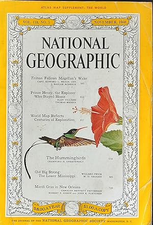
National Geographic Magazine November 1960 / "TRITON FOLLOWS MAGELLAN'S WAKE"- Capt. Edward L. Beach and J. Baylor Roberts / "PRINCE HENRY, THE EXPLORER WHO STAYED AT HOME" Alan Villiers and Thomas Nebbia / WORLD MAP REFLECTS CENTURIES OF EXPLORATION / "THE HUMMINGBIRDS" Crawford H. Greenewalt / "OLD BIG STRONG: THE LOWER MISSISSIPPI" Willard Price and W.D. Vaughn / "MARDI GRAS IN NEW ORLEANS" "Carolyn Bennett Patterson"
Published by The National Geographic Society, 1960
Magazine / Periodical
US$ 20.76
US$ 14.78 shipping
Ships from United Kingdom to U.S.A.Quantity: 1 available
Add to basketSoft cover. Condition: Very Good. "TRITON FOLLOWS MAGELLAN'S WAKE"- Capt. Edward L. Beach and J. Baylor Roberts / "PRINCE HENRY, THE EXPLORER WHO STAYED AT HOME" Alan Villiers and Thomas Nebbia / WORLD MAP REFLECTS CENTURIES OF EXPLORATION / "THE HUMMINGBIRDS" Crawford H. Greenewalt / "OLD BIG STRONG: THE LOWER MISSISSIPPI" Willard Price and W.D. Vaughn / "MARDI GRAS IN NEW ORLEANS" "Carolyn Bennett Patterson".
-
The Children of Africa: Written for all English-Speaking Children
Language: English
Published by Hodder & Stoughton Ltd., London, 1886
Seller: Ryde Bookshop Ltd, Isle of Wight, United Kingdom
Seller rating 5 out of 5 stars
US$ 27.67
US$ 26.81 shipping
Ships from United Kingdom to U.S.A.Quantity: 1 available
Add to basketHardcover. Condition: Good. With map and illustrations (illustrator). Decorated illustrated gray cloth boards. Brown end papers, gilt closed page edges. Front inner hinge cracked. Foxing marks on some pages. No jacket, old gift inscription inside.
-
Boston Furniture of the Eighteenth Century: a Conference Held By the Colonial Society of Massachusetts, 11 and 12 May 1972.
Published by University Press of Virginia, 1974
US$ 24.22
US$ 40.30 shipping
Ships from United Kingdom to U.S.A.Quantity: 1 available
Add to basketHard Cover. Condition: Very Good. Dust Jacket Condition: Very Good. Photoillustrated, with folded map of old Boston. (illustrator). Cloth. John Cogswell ( Museum of Fine Arts, Boston,William Francis Warden Fund 1973) (illustrator). First Edition. Collected papers presented at the conference. Gilt-stamped blue cloth, in black-lettered yellow and white illustrated dust jacket. 316 pp. Size: 8vo - over 7�" - 9�" tall.
-
Caermarthenshire . Antiquarian Map. 1860
Language: English
Publication Date: 1860
Seller: K Books Ltd ABA ILAB, York, YORKS, United Kingdom
Association Member: ABA ILAB PBFA
Seller rating 5 out of 5 stars
US$ 34.59
US$ 26.20 shipping
Ships from United Kingdom to U.S.A.Quantity: 1 available
Add to basketNo Binding. Condition: Very Good. A splendid original coloured antiquarian map printed circa 1860. Mounted (matted) ready to frame . Very good Condition . Shows railways, canals, market towns, hundreds, etc etc . Attractive map of Caermarthenshire .
-
Brecknockshire. Antiquarian Map. 1860
Language: English
Publication Date: 1860
Seller: K Books Ltd ABA ILAB, York, YORKS, United Kingdom
Association Member: ABA ILAB PBFA
Seller rating 5 out of 5 stars
US$ 34.59
US$ 26.20 shipping
Ships from United Kingdom to U.S.A.Quantity: 1 available
Add to basketNo Binding. Condition: Very Good. A splendid original coloured antiquarian map printed circa 1860. Mounted (matted) ready to frame . Very good Condition . Shows railways, canals, market towns, hundreds, etc etc . Attractive map of Brecknockshire .
-
Image Forum June 1980 inaugural issue special feature: Film System
Published by Gedeleo Publishing, 1980
Condition: Fine. Number of books: 1.
-
Los Angeles from the Days of the Pueblo Together with a Guide to the Historic Old Plaza Area Including the Pueblo De Los Angeles State Historical Monument By W. W. Robinson, SIGNED
Published by California Historical Society, 1959
Seller: Bluff Park Rare Books, LONG BEACH, CA, U.S.A.
Association Member: IOBA
Seller rating 5 out of 5 stars
First Edition Signed
Hard Cover. No Jacket. First Edition. HB NODJ, Beige cloth decorated & Lettered in Blue, 1959 , 1st Edition, NICE CONDITION with 1 Very Loose Color Plate in back, F-/NF, NODJ, 96 pgs. Signed by Author.
-
The Island of Navassa Illustrated from Sketches by Eugene Gaussoin
Published by [lithographed by E. Sachse & Co.], [Baltimore], 1866
Seller: F�ldv�ri Books, Budapest, Hungary
Seller rating 5 out of 5 stars
First Edition
Tinted lithographic title; one typeset leaf of text (Navassa; Explanation of the Plates); six colored lithographic plates (Topographical Map; Low Beach; The Harbor; Lulutown and Old Diggings; Lulu Bay; Diggings). (illustrator). First edition. Tinted lithographic title; one typeset leaf of text (Navassa; Explanation of the Plates); six colored lithographic plates (Topographical Map; Low Beach; The Harbor; Lulutown and Old Diggings; Lulu Bay; Diggings). First edition. In the publisher's brown half cloth, embossed title on both boards, gilt on the front cover. [1] leaf tinted lithographic title, [2] pp., [6] leaves of colored lithographic plates. Folio (44 � 54 cm). Rare illustrated album documenting the exploitation of Navassa Island under the Guano Islands Act, with detailed visual evidence of nineteenth-century phosphate extraction, U.S. agricultural and imperial expansion, and the Black labor force on which it depended. Large-format illustrated album, a technical-promotional publication produced in support of guano and phosphate extraction on Navassa Island, a small Caribbean island located some thirty miles southwest of the Haitian coast. Comprising a geological and topographical text with a suite of six tinted lithographic plates executed by E. Sachse & Co., Baltimore, the work presents the island explicitly as the property of the Navassa Phosphate Company of New York. It combines the functions of scientific report and corporate prospectus, documenting the island's geological value, demonstrating the feasibility and efficiency of phosphate extraction, reassuring investors and managers at a distance, and legitimizing its commercial occupation under U.S. auspices. By the mid-nineteenth century, guano had become a valued fertilizer in the United States, as agricultural expansion and soil exhaustion drove demand for concentrated nutrients. Rising prices and fears of depletion led to the Guano Islands Act of 1856, which enabled U.S. citizens to claim unoccupied guano- and phosphate-bearing islands for the United States. As one of numerous small islands brought under U.S. administration through this framework, Navassa was claimed in 1857. Operating under this legal framework, the Navassa Phosphate Company undertook the exploitation of the island, accompanied by a series of publications intended to inform and attract investors. The present lavishly produced album is the most extensive and visually elaborate of these efforts. Its short text combines geographical description, geological explanation, and operational commentary, emphasizing both the quality of Navassa's guano in comparison with the widely used Peruvian guano and the exceptional scale of the deposits, while stressing favorable working conditions, a healthy climate with minimal sickness, and secure anchorage and shipping, presenting the island as well suited to sustained industrial activity. The lithographic plates, based on Gaussoin's sketches, form an integral part of the album's argument. A detailed topographical map and sectional profile present the island as a measured and manageable space, intended to facilitate the efficient control of distant operations. Coastal and harbor views depict calm seas and orderly anchorage, highlighting a well-developed industrial infrastructure-rail tracks, wharves, hoisting devices, workshops, storage buildings, and temporary shelters. Black workers are shown at different stages of extraction and shipment, digging phosphatic material-under the supervision of white guards-moving it on railway carts, and loading boats. Taken together, the images present Navassa as a fully organized working site, offering direct visual evidence of the conditions under which production was carried out. Alongside its industrial focus, the album also records elements of the island's natural environment. Vegetation appears selectively, with palms and scrub framing the worked landscape, while iguanas in the foreground of the digging scenes and seabirds in flight or along the cliffs recur across the plates. These animals directly reflect the text's explanation of the deposits as formed from the accumulated dung and bones of seabirds and large lizards over long periods. The album was produced by Eugene Gaussoin (1812-1881) of Baltimore, a Belgian-born U.S. mining engineer and metallurgist closely associated with the Navassa Phosphate Company. In the same year, he issued Memoir on the Island of Navassa (West Indies) (Baltimore, 1866), addressed to the company's management and intended to justify further investment and operational expansion. Beyond his engineering role, Gaussoin also acted as a scientific observer and collector, gathering zoological specimens later used in scientific description. His writings identify seabirds and large lizards as central agents in the formation of the phosphate deposits; several species later recognized as endemic were first collected at this time, while others were subsequently exterminated during sustained human occupation. Despite the album's consistently favorable presentation of the island, emphasizing health, order, and operational efficiency, conditions on Navassa were in reality harsh, shaped by extreme terrain, isolation, and a coercive labor regime. The workforce, numbering approximately 150-180 Black men, largely recruited in Maryland on fifteen-month contracts, was paid low wages subject to deferred payment, deductions for sickness, fines, and compulsory purchases from a company store, often leaving laborers with little or no pay at the end of their term. Housing was rudimentary, discipline severe, and complaints ineffective. Tensions culminated in a violent labor uprising in September 1889, during which several white supervisors were killed, bringing national attention to the conditions under which the island had been worked and effectively ending large-scale operations. The Navassa Phosphate Company continued nominal operations until the disruption of the Spanish-American War, after which it went bankrupt and abandoned its claim to the island around 1901. Navassa's legal status has remained contested, with Haiti continuing to assert sovereignty, underscoring the distance between the album's promotional narrative.
-
Leather Bound. Condition: New. Language: English. {Size: 14.60 x 22.86 cms} Presenting an Exquisite Leather-Bound Edition, expertly crafted with Original Natural Leather that gracefully adorns the spine and corners. The allure continues with Golden Leaf Printing that adds a touch of elegance, while Hand Embossing on the rounded spine lends an artistic flair. This masterpiece has been meticulously reprinted in 2026, utilizing the invaluable guidance of the original edition published many years ago in 1896. The contents of this book are presented in classic black and white. Its durability is ensured through a meticulous sewing binding technique, enhancing its longevity. Imprinted on top-tier quality paper. A team of professionals has expertly processed each page, delicately preserving its content without alteration. Due to the vintage nature of these books, every page has been manually restored for legibility. However, in certain instances, occasional blurriness, missing segments, or faint black spots might persist. We sincerely hope for your understanding of the challenges we faced with these books. Recognizing their significance for readers seeking insight into our historical treasure, we've diligently restored and reissued them. Our intention is to offer this valuable resource once again. We eagerly await your feedback, hoping that you'll find it appealing and will generously share your thoughts and recommendations. Lang: - English, Pages:- 71, Print on Demand. If it is a multi-volume set, then it is only a single volume. We are specialised in Customisation of books, if you wish to opt different color leather binding, you may contact us. This service is chargeable. Product Disclaimer: Kindly be informed that, owing to the inherent nature of leather as a natural material, minor discolorations or textural variations may be perceptible. Explore the FOLIO EDITION (12x19 Inches): Available Upon Request. 71.
-

1814 Denmark.
Seller: New World Cartographic, Chicago, IL, U.S.A.
Seller rating 4 out of 5 stars
Map
By: John ThomsonDate: 1814 (circa) EdinburghDimensions: 19.75 x 23.25 (50.17 x 59.06 cm)This handsome large format map from Thomson's New General Atlas features Denmark along with two insets depicting Iceland, and the Faroe Islands. Portions of Sweden and Germany are also depicted. The maps are engraved in the minimalist English style pioneered in the early part of the 19th century, a style which reduced maps' decorative elements to a minimum. Relief is shown by hachure with towns, cities, and major topographical features all identified.On December 1st, 1918, a Danish-Icelandic federal law was passed in both parliaments establishing Iceland as an independent state yet retaining a personal union with Denmark. Thus while Iceland is a free and sovereign state with an independent government, it yet has political ties to Denmark.Iceland has been mapped countless times, and Thomson's map offers relatively little detail when compared with many other maps of the island. It does depict the rugged terrain of the island, but offers little more in detail than the naming of major ports, cities and fjords. The volcanic features of the island are popular tourist attractions but are not named in this map.The Faroe Islands consist of a group of 18 volcanic islands in the middle of the North Atlantic Ocean, northwest of Scotland and halfway between Iceland and Norway. The Islands are a self-governing island territory of Denmark. They have a population of nearly 50,000, and a language and culture of their own, the populace being largely descended from Viking settlers. When visiting the Faroes one is never more than 5 km (3 miles) away from the ocean.John Thomson (1777 - 1841) was a Scottish cartographer, publisher, and bookbinder active in Edinburgh during the early part of the 19th century. Thomson apprenticed under Edinburgh bookbinder Robert Alison. Thomson was one of the leading publishers in the Edinburgh school of cartography, which flourished in the early decades of the 19th century. Thomson and his contemporaries (Pinkerton and Cary) redefined European cartography by abandoning typical 18th century decorative elements such as elaborate title cartouches and fantastic beasts in favor of detail and accuracy.Condition: This superb large format map on heavy paper is in A condition. Original coloring.Inventory #119291200 W. 35th Street #425 Chicago, IL 60609 | P: (312) 496 - 3622.
-

1886 Map of the Near North Side Neighborhood of Chicago between Division St. Sedgwick St. Larrabee St. and North Ave.
Seller: New World Cartographic, Chicago, IL, U.S.A.
Seller rating 4 out of 5 stars
Map
E 1/2 of N.W. 1/4 Section 4.39.14.By:Elisha RobinsonDate: 1886 (dated) New YorkDimensions: 20.25 x 29.75 inches (51.5 x 75.5 cm)A large scale map of part of the Chicagos Near North Side neighborhood between Division St. Sedgwick St. Larrabee St. and North Ave.The map is color-coded by the most common type of building material such as brick (pink), wood (yellow), and stone (brown). Since this map was published after the great Chicago Fire of 1871, most the other buildings had been rebuilt with brick and limestone as opposed to wood.The large, bold numbers represent the "block number" and the smaller numbers differentiate individual lots from one another. Small numbers in a circle indicate the elevation of the street, two line side-by-side delineate sewer lines, and small circles with a cross denote the location of fire hydrants. Streets that are uncolored indicate that they have not been paved and are likely dirt or gravel. Circled letters throughout the map correspond to a list of divisions with the names of several land owners at the bottom of the map.Many of the buildings shown are residential but several schoolschurches, factories, and theatres are noted. Two theatresthat can be found within the map include the National Theatre on Clybourn and Criterion Theatre (1881-1934) on Sedgwick. Today the theatre sites are occupied by retail shopping and parking lots. This section of Chicago would also see the Red, Brown, and Purple, lines come through in the 20th century.Condition: This map is in A condition with bright and bold color on relatively clean paper and original linen backing. Some light soiling is apparent as well as a small tear in the top. Pencil markings can also be found, but this is not regarded as a condition issue as this was a working map for some time.Inventory #119831200 W. 35th Street #425 Chicago, IL 60609 | P: (312) 496 - 3622.
-

Historical Map of the Old York Road in Pennsylvania.
Publication Date: 1941
Seller: Geographicus Rare Antique Maps, Brooklyn, NY, U.S.A.
Association Member: ABAA ESA ILAB
Seller rating 4 out of 5 stars
Map
Very good. Three-inch tear on top-side border professionally repaired. A couple small spots of soiling towards top-right. Size 28 x 21 Inches. A charming, scarce 1941 historical pictorial map of the Pennsylvania Old York Road by Howard Kohlbrenner, produced for the Old York Road Historical Society. A Closer Look Coverage includes Montgomery and Bucks County in southeastern Pennsylvania, between Philadelphia and the Delaware River (also the border with New Jersey), which appears at top-right. Both historic and major modern roads are traced and labelled, including, of course, the historic Old York Road, as well as Pennsylvania Route 263, which largely follows this historic road. Extremely rich historical notes appear throughout on structures and sites ranging from the early days of colonial Pennsylvania to the late 19th century. Included are the homes of prominent early families, Quaker meeting houses, churches, cemeteries, bridges, the sites of Revolutionary War actions, and more. An inset at bottom-right provides a closer view of the area around Abington and Jenkintown. The coats of arms of prominent early Pennsylvania families appear at left, along with illustrations of local landmarks. A lovely border and title cartouche provide additional embellishments to the map. The Old York Road The Old York Road was originally an 18th century road build between New Hope, Pennsylvania on the Delaware River and Philadelphia, following an even older trail used by the Raritan (Lenape) people. After a crossing of the Delaware River, the route continued through New Jersey to New York City, providing for the first time a means of overland travel between the two cities by stagecoach. First conceived by William Penn in the late 17th century, the road was surveyed in 1711. Work was slow, with the road opening to New Hope in 1741, to New York City (or rather, Elizabethtown, New Jersey) in 1769, and only reaching downtown Philadelphia in 1771. Along with the Boston Post Road (also known as the Old Post Road) and other regional roads, the Old York Road effectively functioned as America's earliest highway network and spurred a range of economic activity. As the trip between New York and Philadelphia took two days, inns and taverns along the route were necessary. Competing stagecoach companies sprang up to vie over who could provide the fastest and most comfortable ride to their passengers. Publication History and Census This pictorial map was designed and drawn by Howard Kohlbrenner for the Old York Road Historical Society in 1941, though the organization's records refer to an earlier, even rarer, printing of 1936. It is quite scarce, being listed among the holdings of the Wisconsin Historical Society and Swarthmore College. It presumably is also held by the Old York Road Historical Society itself. References: OCLC 854856692.
-

Regnorum Castellae Veteris, Legionis, et Gallaeciae principatuumq Biscaiae, et Asturiarum Accuratissima Descriptio.
Publication Date: 1721
Seller: Geographicus Rare Antique Maps, Brooklyn, NY, U.S.A.
Association Member: ABAA ESA ILAB
Seller rating 3 out of 5 stars
Map
Very good. Overall age toning. Minor wear along original centerfold. Minor creasing. Some spotting. Size 20.5 x 23 Inches. This is a scarce c.1721 map of northwest Spain by Frederik De Wit. The map depicts the northern divisions under the Crown of Castile, including the part of the Kingdom of Leon, the Kingdom of Castile, the Principality of Asturias, the Kingdom of Galicia and the Lordship of Biscay. This region is also an important stop on the medieval pilgrimage route to Santiago de Compostella. It also includes parts of Portugal. The entire map is depicted in extraordinary detail, offering both topographical and political information, with forests and mountains beautifully rendered in profile. A beautifully engraved title cartouche in the top right quadrant features the coats of arms of Galicia, Castile and Biscay held up by three cherubs. A fourth cherub holds up a blank coat of arms. The map was issued by Covens and Mortier and printed shortly following their 1721 acquisition of De Wit's plates from Maria De Wit. References: OCLC: 611378182.
-

1857 Map of the Territory of the United States from the Mississippi to the Pacific Ocean
Seller: New World Cartographic, Chicago, IL, U.S.A.
Seller rating 4 out of 5 stars
Map
Map of the Territory of the United States from the Mississippi to the Pacific Ocean; ordered by Jeffn Davis, Secretary of War to accompany the reports of the explorations for a railroad route.By:Lieut. G. K. WarrenDate: 1857 (dated) Washington D.C.Dimensions: 42.5x 46.5 inches (108 x 118 cm)A well-preserved example of one of the most important and complete maps of the western United States to come out of the mid-19th century. This remarkable cartographic workby Lieutenant Gouverneur Kemble Warren is drawn upon nearly half a century of American exploration, military operations, scientific expeditions, and a massive undertaking in government funded land surveying with the intention of identifying the best route of a trans-continental railroad.Early Visions of a Transcontinental RailroadThe idea for a trans-continental railroad can be traced to a New York business man and importer of goods from China, Asa Whitney. He desperately wanted an overland route to connect his imports of Chinese tea, spices, and other goods from the harbors San Francisco to New York and everywhere in between. In 1846Whitney proposed to congress for a grant of public land to be used to build the nations first ever transcontinental railroad from Lake Michigan to the Pacific. Congress voted down his proposal and in 1849he published a booklet to promote hisvision entitled Project for a Railroad to the Pacific, which made the idea of a transcontinental railroadone of the great public issues of the day.It wasnt long after that in 1853, Secretary of War Jefferson Davis was directed by congress underthe provisions of the Army Appropriation Act, to survey possible routes to the Pacific. Four east to west routes, roughly following specific parallels, as well as a north-south route through the coastal states of Washington, Oregon, and California were to be surveyed by parties under the supervision of the Topographical Corps.Important Events that Created A Window of OpportunitySo what changed since 1846 when Asa Whitneys initial proposal as turned down? For starters, the Mexican-American War came to an end with the signing of the Treaty of Guadaloupe Hidalgo which resulted in the addition of 525,000 square miles of land to the United States. Earlier that same year, gold was discovered at Sutters Mill in the Sierra Nevada mountains of California, sparking a massive movement of fortune seekers that is well-known today as the 49ers.In the east however, tensions were rising over the national debate on abolishing slavery. The compromise of 1850 eased tension between the northern and southern states. It consisted of five laws that dealt with the issue of slavery and territorial expansion. Thus, an ideal window of opportunity was provided to unite the country figuratively and physically with a railroad that would connect the existing populations and opportunities of the western states with the resources and willing emigrants of the eastern states.The Effort, Information,Risk, and Sacrifice Behind this MapThis monumental work,acts as a grad view of the many ongoing surveying expeditions of the American West as well as documentation of information garnered from the many exploring expeditions and military reconnaissance missions and operations from years past. In fact, many of the surveying parties followed much of the routes of Lewis & Clark (1804-06),Long (1819-23) Fremont (1843-44), Sansbury (1849-50) Lient. Albert & Peck (1845) and Colonel Kearny (1846). Many of these routes and others are delineated within the map and in the lower right corner is a list of over forty expeditions, and source maps that preceded this work, beginning with Lewis and Clark in 1804 5-6.Any expansionist efforts by the United States cannot be undertaken withoutconsidering the element of the Native Americans living within the lands surveyed in this map. While many tribes had already been relocated west of the Mississippi onto established reservations, many others where either constantly roaming as their nomadicbands or had established territories, which they would defend to the death.Some were quite peaceable andwould offer guidance and trade with the white men of the east, others would torture and kill many the crossed their sights.The very nature of the job of a land surveyor was extremely dangerous, not just because they were often extremely far from any civilization that could provide supplies and medical attention, but also because many tribes had already come to understand that surveyors were a precursor to land claims by whites and the subsequent development and hostile engagement with the United States Military. Thus, this map offers a great wealth of the most recent cartographic information concerning the location of every Native American tribe known west of the Mississippi.The Potential Routes for a Trans-continental Railroad.As previously stated, the mapis a grand view of four east to west routes, roughly following specific parallels, as well as a north-south route through the coastal states of Washington, Oregon, and Californiathat were beingsurveyed.The following information on these routes was garnered from the Library of Congress.The most northerly survey, between the 47th and 49th parallels, was under the direction of Isaac Ingalls Stevens, governor of Washington Territory. This route closely approximated the proposed by Asa Whitney. The ill-fated party under Capt. John W. Gunnison was to explore the route along the 38th and 39th parallels, or the Cochetopoa Pass route, which was advocated by Missouri Senator Thomas Hart Benton. After Gunnisons death at the hands of hostile Indians, Lt. Edward G. Beckwith continued the survey along the 41st parallel.Capt. Amiel W. Whipple, assistant astronomer of the Mexican Boundary Survey, and Lt. Joseph Christmas Ives surveyed the route along the 35th parallel westward to southern California. This line was favored by Jefferson Davis and was essentially the route traversed by Josiah Gregg in 1839 and later s.
-

Historical Map of Nantucket.
Publication Date: 1889
Seller: Geographicus Rare Antique Maps, Brooklyn, NY, U.S.A.
Association Member: ABAA ESA ILAB
Seller rating 3 out of 5 stars
Map
Very good. Old repair to margin tear on verso. Size 9 x 14.25 Inches. This attractive c. 1886 map is a reduced version of Reverend F. C. Ewers important 1869 map of Nantucket. It was issued to promote the Old Colony Line, the 'Shortest, Quickest, Best, and Only Direct Route between Boston or New York and Nantucket and Martha's Vineyard.' A Closer Look Printed in Nantucket, this variant was issued by the Old Colony Line in various formats from roughly 1872 to 1889. The map includes a textual timeline of Nantucket from its discovery by Bartholomew Gosnold in 1602 to the laying of the first communications cables between Nantucket and the mainland in 1886 - hence our dating. The Ewer Map The Nantucket historian Joseph Garver provides an excellent description Ewer's map provides a detailed synopsis of Nantucket's history, beginning with Gosnold's sighting of the island in 1602. The chronological table identifies the major stages in Nantucket's development - its early settlement and land divisions, the evolution from shore to deep-sea whaling, the establishment of religious and educational institutions, and the development of the transportation network connecting Nantucket with the mainland (and Nantucketers with one another). Ewer also notes events that marked the transition from one era to the next - the first island whaler to seek its prey in the Pacific (1791), the death of the last Indian (1822), the great fires of 1836 and 1846, and the first gaslight in 1854. In a more graphic form, the map indicates the sites of old settlements and burial grounds, as well as the boundaries of sachem rights, the former shoreline, old fishing stages, and whaling stations. (Garver, G. Surveying the Shore , p. 115.) The Present Map The present map follows the updates and modifications to the Ewer plan introduced by J. B. Swain in or around 1886. Swain's revisions of the large-scale original were intended for a reissue promoting the Hotel Nantucket, shown here on Brant Point. The hotel was a response to growing 'summering' interest in Nantucket and was the first major hotel on the island. We know Swain was a Nantucket hotelier in his final years, so his association with the Hotel Nantucket, while not fully verified, is almost certain. We also know that the hotel was built on 'Society of Friends' land, and that Swain was closely associated with the 'Friends' in Nantucket. In any case, Swain massively revised the Ewer map. He further updated it to reflect recent changes on the island, including the construction of the Hotel Nantucket, the Nantucket Railroad from the harbor to Surfside and on to Siasconset, and life-saving stations at Coskata and Muskeget Island. He also notes, in 1877, the 'Great Temperance Movement.' The table of historical events has been updated to 1886 and reflects these and other developments. Old Colony Line The Old Colony Line was a subsidiary of the Old Colony Railroad, which from 1844, developed and operated a rail line between Boston and Plymouth. By acquiring or merging with its competitors, the Old Colony Railroad became the dominant railroad in southeastern Massachusetts. They expanded their network with steamship service between New York City and Fall River. In 1872, they inaugurated the Old Colony Line, a steamer between Woods Hole, Martha's Vineyard, and Nantucket. The Old Colony Railroad was acquired in 1893 by the New York, New Haven, and Hartford Railroad. Some of the railroads established by the Old Colony Railroad remain in operation to this day, among them the Old Colony and Newport Railway. Publication History and Census This map has a complex, confusing, and little-researched publication history. It was originally drawn and published by Ferdinand Cartwright Ewer in 1869. That edition was large, measuring more than 40 inches wide. It was reissued around 1886 for the opening of the Nantucket Hotel. Around the same time, a reduced version emerged to promote the Old Colony Line, with a large medallion to this ef.
-

Africae described , the manners of their Habits, and buildings newly done into English by I. S. Are to be sold by Tho Basset in Fleet Street, and Ric Chiswell in St. Pauls Churchyard.
Publication Date: 1676
Seller: Geographicus Rare Antique Maps, Brooklyn, NY, U.S.A.
Association Member: ABAA ESA ILAB
Seller rating 4 out of 5 stars
Map
Very good. Two creases with no loss to printed image, reinforced bottom centerfold, else excellent with beautiful old color and full margins. Size 15.25 x 20 Inches. This is John Speed's 1626 map of Africa, the first English map of the continent. This beautiful map is one of the most desirable early maps of Africa, combining superb engraving, attractive Dutch styling, and entertaining and abundant English text. Moreover, the present example sports old color of unusually high quality. A CloserLook Speed was an accomplished historian and compiler, drawing his maps from state-of-the-art sources. In this case, the cartography for this map is drawn from the maps of Jodocus Hondius (whose student Goos actually engraved the map). Hondius' source was ultimately Willem Blaeu's 1608 wall map of Africa. As is the case with all of these maps, the map demonstrates 17th century European geography's detailed knowledge of Africa's coasts wedded to a deep mystification of the interior. The course of the Nile, for example, is shown in substantially the same configuration as was supposed in the second century by Claudius Ptolemy. Speed adds descriptive text - for example, noting areas in western and central Africa where gold is said to be found, and indicating areas said to be occupied by Amazons. Presenting the Idea of Africa Visually, the map shares with Blaeu the decorative elements associated with the carte � figures as a form: key city views along the top border, along with figures to the left and right depicting the denizens of the lands. The cities are North African, with the exception of Canaria and Mozambique, and all reflect the coastal limitations of European penetration into Africa. In addition to the borders, the body of the map is richly decorated with sailing ships, sea monsters, flying fish, elephants, ostriches, lions, and a zebra. The Engraver Speed's adoption of the Dutch carte � figures map style (and indeed, the entirety of the Dutch state-of-the-art for the mapping of Africa) becomes unsurprising when one considers the degree to which Speed was dependent on Dutch engravers. Virtually all of the maps produced for Speed during his lifetime were executed by Jodocus Hondius and (as is the case here) his prot�g� and student Abraham Goos: it would appear that, until well into the 17th century, the art of engraving in the British Isles was unequal to the challenge posed by the production of maps. Not until this 1676 Bassett and Chiswell edition of Speed's work would maps be included that were actually executed by an Englishman, Francis Lamb. Color on Speed Maps Whereas the Dutch and Flemish mapmakers systematically colored a significant portion of their atlases, Speed's various publishers very seldom colored these maps at the time of their publication. While Speed maps with attractive color can be easily found, these were by and large colored later and even recently. The coloring on the present example, however, displays evidence of oxidation consistent with age; since the palette conforms to 17th century fashion, we do not think it likely that this was colored very long after the map's 1676 printing. (Original color of the late seventeenth and into the eighteenth century did not resemble this.) Publication History and Census Although Speed died in 1629, his atlas was kept active long afterwards as its plates passed from George Humble to William Garrett to Roger Rea and ultimately to Basset and Chiswell, whose final edition of 1676 is the most easily found. This 1676 edition of the separate map is only listed four times in OCLC: at Stanford, the Biblioth�que National, the University of Witwatersrand, and the University of Kwazulu, Natal. Basset and Chiswell's Theatre of the Empire of Great-Britain is well represented in institutional collections. References: Betz. R. L., A Cartobibliography of Printed Maps of the African Continent to 1700, #62.3. Norwich, O., Norwich's Maps of Africa: An illustrated and Annotated Carto-biblio.
-
New-York City and County Map with Vicinity entire Brooklyn Williamsburgh Jersey City an c. in the 79th Year of Independence of the United States.
Publication Date: 1855
Seller: Geographicus Rare Antique Maps, Brooklyn, NY, U.S.A.
Association Member: ABAA ESA ILAB
Seller rating 3 out of 5 stars
Map
Very good. Comes with original binder. Map has been backed on archival tissue. There were a few older repairs on the verso, which causes some slight discoloration on the recto (apparent as brown spots). We have reversed and redone these repairs with archival materials. Original old color. Size 20 x 32 Inches. The rare full-color edition of Charles Magnus's extraordinary 1855 broadside map of New York City, issued to commemorate the signing of the Declaration of Independence. This is one of the finest and most visually striking maps of New York City to appear in the 19th century. Moreover, the present example is only the 2nd full original color example of this map we have seen. A Closer Look The map depicts the entirety of Manhattan as well as most of Brooklyn, Bedford-Stuyvesant, Williamsburg, Greenpoint, Queens, Ravenswood, Astoria, Jersey City, and Hoboken. An inset map at the bottom center details Long Island. The whole is rendered in detail with special attention given to individual streets, blocks, parks, and important buildings. The map reveals the early growth of Hunters Point, or Long Island City in Queens. Important ferry crossings, canals, and railroads are also included. In Hoboken, Jersey City, and Long Island City, several planned landfills are indicated. Also in Hoboken, we see the Elysian Fields, a park along the Hudson River that hosted the world's first baseball game. Manhattan In Manhattan, the map identifies various districts including Manhattanville, Yorkville, and Harlem. Central Park has yet to manifest and although the grid structure above 155th Street is ghosted in, it was not yet formally approved. Where Columbia University stands today, this map shows the location of the New York Lunatic Asylum. At the bottom center an alphanumerically keyed legend notes 'Universities, Colleges and Scientific and Literary, Benevolent-Institutions,' 'Public Buildings', and 'Places of Amusement.' In the lower left, there is an inset engraved depiction of New York's City Hall. Steamships are shown navigating the Hudson River in both the upper right and upper left quadrants. The Medallion In the lower right an elaborate medallion features the full text of the Declaration of Independence as well as sigils representing each of the original 13 colonies. A bright blue pastedown, unique to this example, declares the purpose of this map, to commemorate the 79th Year of the Independence of these United States . The whole is surrounded by an attractive acanthus leaf motif border. Publication History and Census This map was issued in lithograph in 1855 by the New York publisher Charles Magnus. Most examples are broadsheets, in black and white, intended for framing. At the same time, a few examples were issued as folding pocket maps, as here. These few were elaborated with a full hand-color treatment. While we have seen and handled other examples of the uncolored broadside, this is only the second example we have seen of this, full-color issue (the other one having passed through our hands about 5 years previous). It is unfortunately impossible to identify if examples held in some institutional collections are uncolored broadsides or colored pocket maps, as most are poorly cataloged and not digitized. It is nonetheless of extreme rarity on the market in any state, but particularly this full-color issue. References: OCLC 23876813. Haskell, Daniel Carl, Manhattan Maps; a Co-operative List, 1004.


![Seller image for Atlas of the city of Hartford, Connecticut, including, also, the town of West Hartford 1896 [Leather Bound] for sale by Gyan Books Pvt. Ltd.](https://pictures.abebooks.com/inventory/md/md32386990382.jpg)
