Order Total (1 Item Items):
Shipping Destination:

Ottens Joachim (13 results)
Skip to main search results
Search filters
Product Type
- All Product Types
- Books (4)
- Magazines & Periodicals (No further results match this refinement)
- Comics (No further results match this refinement)
- Sheet Music (No further results match this refinement)
- Art, Prints & Posters (2)
- Photographs (No further results match this refinement)
- Maps (7)
- Manuscripts & Paper Collectibles (No further results match this refinement)
Condition Learn more
- New (1)
- As New, Fine or Near Fine (2)
- Very Good or Good (2)
- Fair or Poor (No further results match this refinement)
- As Described (8)
Binding
- All Bindings
- Hardcover (No further results match this refinement)
- Softcover (4)
Collectible Attributes
- First Edition (No further results match this refinement)
- Signed (No further results match this refinement)
- Dust Jacket (1)
- Seller-Supplied Images (8)
- Not Print on Demand (13)
Language (2)
Free Shipping
Seller Location
Seller Rating
-
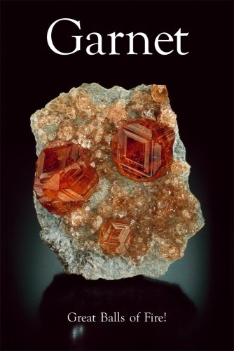
Garnet: Great Balls of Fire
Seller: Goodwill of Colorado, COLORADO SPRINGS, CO, U.S.A.
Seller rating 5 out of 5 stars

Condition: very_good. Roberto Appiani; Michael Bainbridge; Modris Baum; Dan Behnke; Joe Budd; Thomas Calligaro; Jeff Scovill; William B. Simmons; Joachim Zang; Gary Zito; Berthold Ottens; Ed Raines; Stefan Weiss; Herwig Pelckmans; George F. Kunz; Gilla Simon; John Smolski (illustrator). Item may have minor cosmetic defects marks, wears, cuts, bends, crushes on the cover, spine, pages or dust cover. Shrink wrap, dust covers, or boxed set case may be missing. Item may contain remainder marks on outside edges, which should be noted in Product Details. Item may be missing bundled media.
-

M�nnlich - weiblich, t�rkisch - deutsch. Lebensverh�ltnisse und Orientierungen von Industriebesch�ftigten.
Published by Opladen. Leske + Budrich. ., 1999
ISBN 10: 3810023833 ISBN 13: 9783810023834
Seller: Antiquariat & Verlag Jenior, Kassel, HE, Germany
Seller rating 5 out of 5 stars
344 S. Kartoniert. Sauberes Exemplar ohne Stempel und Anstreichungen. Mit einigen Abbildungen. Umschlag etwas berieben. Kanten und Ecken leicht angesto�en. Leichte Knickspuren. Sonst gut erhalten. Sprache: deu.
-
Soft cover. Condition: Fine. Roberto Appiani; Michael Bainbridge; Modris Baum; Dan Behnke; Joe Budd; Thomas Calligaro; Jeff Scovill; William B. Simmons; Joachim Zang; Gary Zito; Berthold Ottens; Ed Raines; Stefan Weiss; Herwig Pelckmans; George F. Kunz; Gilla Simon; John Smolski (illustrator). Used, minor damage to upper right corner, does not inhibit quality of the pages. Great condition otherwise. Book is filled with information on the subject of Garnet and the related minerals that it is found with in relation to its locality. Stunningly beautiful photographs of Garnet in its crystalline forms and garnets prized for their unique formations and famous attributions through history.
-
US$ 103.13
US$ 13.42 shipping
Ships from United Kingdom to U.S.A.Quantity: 1 available
Add to basketPaperback. Condition: Brand New. Roberto Appiani; Michael Bainbridge; Modris Baum; Dan Behnke; Joe Budd; Thomas Calligaro; Jeff Scovill; William B. Simmons; Joachim Zang; Gary Zito; Berthold Ottens; Ed Raines; Stefan Weiss; Herwig Pelckmans; George F. Kunz; Gilla Simon; John Smolski (illustrator). no. 11 edition. 104 pages. 11.50x8.20x0.40 inches. In Stock.
-

Venetia
Published by Amsterdam, Venetia, 1720
Seller: libreria antiquaria perini Sas di Perini, Verona, VR, Italy
Seller rating 5 out of 5 stars
Art / Print / Poster
Incisione in rame su due fogli uniti, mm 500x713, firmata da Joachim Ottens in basso a destra. Stato unico. Splendida impressione, molto contrastata. La pianta, di derivazione da quella di Merian, nella parte superiore riporta il titolo VENETIA, mentre in basso la stampa riporta due vedute di piazza San Marco, a sinistra "Piazza de S. Marco in Venetia" vista dalla laguna, a destra "Altra parte della piazza S. Marco in Venetia" colta verso la Basilica dal Correr. Al centro due riquadri con nobili e dame veneziane. Curioso notare come la veduta non sia aggiornata topograficamente: infatti la punta della Dogana � ancora nella vecchia struttura e manca ancora la Chiesa della Salute. L'attivit? di stampa e vendita di mappe della famigia venne fondata da Joachim Ottens, ma il periodo attivo della pubblicazione delle mappe si concentr� tra gli anni 1720 and 1750, quando i fratelli Reiner e Joshua realizzarono una enorme collezione di mappe, alcune delle quali grandi come 15 volumi. Queste, incluse le copie di praticamente tutte le mappe reperibili all'epoca, erano magnificamente colorate, preparate su ordinazione. Oltre alle collezioni preparate per clienti speciali, hanno anche pubblicato atlanti in volumi singoli, con vari contenuti, cos� come atlanti tascabili. Bibliografia: Moretto, Venetia, le immagini della Repubblica, n. 143Copper engraving on two joined sheets, signed by Ottens at bottom right handside, 500x713 mm. Single state. Splendid impression, highly contrasted. The plan, derived from that of Merian, bears the title VENETIA at the top, while at the bottom the print shows two views of St. Mark's Square, on the left "Piazza de S. Marco in Venetia" seen from the lagoon, on the right "Altra parte della piazza S. Marco in Venetia" taken towards the Basilica from the Correr. In the centre are two panels with Venetian nobles and ladies. It is curious to note that the view is not topographically up-to-date: in fact, the tip of the Dogana is still in the old structure and the Salute Church is still missing. The family's business of printing and selling maps was founded by Joachim Ottens, but the active period of map publishing was concentrated between the 1720s and 1750s, when the brothers Reiner and Joshua built up a huge collection of maps, some of them as large as 15 volumes. These, including copies of virtually all maps available at the time, were beautifully coloured, prepared to order. In addition to collections prepared for special customers, they also published atlases in single volumes, with various contents, as well as pocket atlases. Bibliografia: Moretto, Venetia, le immagini della Repubblica, n. 143 Nr.cat: Cod 7650.
-

Nieuwe kaart van Suriname.
Published by Amsterdam, 1720
Seller: libreria antiquaria perini Sas di Perini, Verona, VR, Italy
Seller rating 5 out of 5 stars
Art / Print / Poster
Copper engraving, mm 400x520, original colour. Decorative full color example of Ottens map of Surinam. Detailed map of the northeast part of Surinam between Paramaribo and Mana. Nice wide margined example. Blank verso. Nr.cat: 6522.
-
Le Royaume de Siam avec les Royaumes qui les sont Tributaires
Published by Joachim Ottens c. 1708, Amsterdam, 1708
Seller: Alexandre Antique Prints, Maps & Books, Toronto, ON, Canada
Seller rating 4 out of 5 stars

Map
Condition: Very Good. A very good example of Joachim Ottens? superb map of the Kingdom of Siam and its dependent states. The map depicts Thailand, Cambodia, Vietnam, northern Borneo, and northern Malaysia. It also shows the explorations and details of the Jesuit expeditions into the region. Joachim Ottens (1663-1719) was a prominent bookseller and map publisher in Amsterdam., Size : 354x550 (mm), 13.94x21.65 (Inches), Original Hand Coloring.
-

Nova et Accurata Geographica Tabula Insulae Corfu seu Corcyrae cum Confinis suis ac Portubus ex Adverso in Graecia Iacentibus. Auctore Joachimo Ottens Amstelodami.
Publication Date: 1717
Seller: Geographicus Rare Antique Maps, Brooklyn, NY, U.S.A.
Association Member: ABAA ESA ILAB
Seller rating 4 out of 5 stars
Map
Very good. Marginal split not impacting image, else excellent. Size 20.25 x 16 Inches. This is Joachim Ottens' rare, beautiful 1717 map of Corfu. It was published in the wake of the famous 1716 Siege of Corfu; the victory is alluded to with the decorative element of the Venetian Lion of Saint Mark, sword upraised while kicking aside an Ottoman scimitar and turban. Ottens' map proved the canonical mapping of Corfu for the rest of the century. A Closer Look The main map delineates the island of Corfu, with the Greek coastline to the west. Terrain is shown pictorially, as are salt pans, forests, and vineyards. As with most contemporaneous maps, it is derived from the foundational 1672 map by Andrea Marmora, but has been updated in several areas. Notably, the lake in the west of the island, appearing on Marmora's map and most of its derivatives, has here been replaced with vineyards. Historically, swampland had existed there, swelling to the depth of a lake; drainage projects over the course of the 18th century would result in the disappearance of the lake altogether. The depth soundings of the southern approach to Corfu shown on this map do not appear on the 1672 Marmora. A surviving 1716 Gerard Van Keulen chart of Corfu is the likely source for these elements. An inset in the upper left shows Corfu's strategic position, governing the passage between the Gulf of Venice and the Mediterranean Sea, bottlenecked between the Greek coastline and the boot-heel of Italy. The latter is presented based on the mapping of Magini, for better or for worse. While Magini's was the most accepted mapping of Italy throughout the 17th century, it contained a glaring error, reproduced here: the nonexistent island of Monte Sardo in the Gulf of Taranto. The lower left inset focuses on the city and fort of Corfu, on the island's eastern shore. It lays out the old and new forts defending the city and harbor, and mainly follows the model followed by Joan Blaeu, prepared for his town book but not published until 1704 by Pierre Mortier. Ottens' copy includes the descriptive table keyed to the plan. But it includes a detailed depiction of a further stage of improvements to the city's walls, particularly an additional layer of glacises facing the land approaches of both the new fort and the old. This is important, as Venetian forces had been actively upgrading the defenses of the city in preparation for an Ottoman attack. By the time of the Second Ottoman Siege of Corfu in 1716, these defenses were complete. The Venetian victory is largely ascribed to their improvements to the city's defenses in advance of the war. Publication History and Census This map was produced by Joachim Ottens in Amsterdam no earlier than 1716; after Joachim's 1719 death, the map likely remained in the atlases published by his sons Renier and Josue, but it is seldom on the market and appears in fewer than 20 institutional collections. References: OCLC 1062266921. Zacharakis, C. G., A Catalogue of Printed Maps of Greece 1477-1800 #2523.
-

Suriname - Joachim Ottens, ca
Seller: Inter-Antiquariaat Mefferdt & De Jonge, Amsterdam, Netherlands
Seller rating 3 out of 5 stars

Map
US$ 1,734.31
US$ 48.77 shipping
Ships from Netherlands to U.S.A.Quantity: 1 available
Add to basket"Nieuwe Kaart van SURINAME vertonende de stromen en land-streken van SURINAME, COMOWINI, COTTICA en MARAWINI gelegen in Zuid America op de kusten van Caribana 6 gr. Benoorden de Linie Enquinocqt." [New Map of Suriname showing the rivers and territories of Suirname, Comowini, Cottica, and Marawini located in South America on the coasts of Caribana 6 degrees North of the Equator.] Copper engraving made by Joachim Ottens, published in Amsterdam ca. 1715. With original hand colouring. Size: approx. 40 x 50 cm. There was a time when adventurous, fearless, profit-seeking Europeans sailed into the open world, planted their flags on foreign shores, and then considered that land their own. The local population usually didn't benefit much from this. Moreover, large numbers of slaves were often brought in from elsewhere to work under inhumane conditions on plantations. It's difficult to imagine today that it happened like this, but Suriname is a striking example. The area we call Suriname, or rather the northern coast of the South American continent, was first sighted by Europeans in 1499. They were initially not very impressed and disregarded the area. That changed when fantastic stories began circulating about El Dorado, the land where gold was supposedly abundant. Inspired by this, many Europeans in the 16th century ventured again to try their luck in what was then called Guyana. Portuguese and Spanish initially had the upper hand, but later, English, French, and Dutch also headed in that direction. They made contact with the local population, established a few settlements, and engaged in some trade. Most of the conflict occurred with the Spaniards and Portuguese, who, according to the Treaty of Tordesillas of 1494, still considered the region as 'theirs' and didn't tolerate intruders. However, the English succeeded in colonizing Suriname in the mid-17th century. With the establishment of sugar plantations, they had gained experience elsewhere in the Caribbean: they put slaves to work, and in a short time, a part of the land was drained and a large number of plantations were founded. The Dutch also had great interest in this area. During the Second Anglo-Dutch War (1665-1667), a fleet sailed from Zeeland to South America with the aim of conquering Suriname, which relatively easily succeeded in 1667. In July of that year, the Treaty of Breda was signed, formalizing this situation. The years thereafter show a rather chaotic and volatile picture of the colony's administration by the Dutch. A new phase began in 1683 when the Society of Suriname was established, representing three parties simultaneously: the Dutch West India Company, the city of Amsterdam, and the Van Aerssen van Sommelsdijck family. The charter of this society regulated the powers of the colonists, which included a considerable degree of autonomy not comparable to other colonized areas in the East Indies (present-day Indonesia) and North America (the region around New Amsterdam). Attempts by the Society of Suriname to attract other settlers to establish themselves in Suriname met with limited success, and it was not always just the Dutch. Huguenots and Germans also settled in Suriname, as did a relatively large number of Jews. Because of this, the European community in Suriname showed little cohesion. At the end of the 18th century, there were about 3,300 Europeans living there, compared to tens of thousands of slaves who were working on the plantations under shameful and poor conditions. It wasn't until July 1, 1863, that slavery was abolished. The Netherlands was one of the last countries in Europe to do so. The map names a large number of plantations along the Suriname, Commewijne, Cottica, and Marowijne rivers. Remarkable is the "Ioods Dorp en Sinagoge" (Jewish Village and Synagogue) on the Suriname River, surrounded by a large number of plantations with Jewish owners (as indicated by Spanish-Portuguese names like Abram de Pina, Barug de Costa, Serfatyn, etc.). Also i.
-

Stadsvrijheid van Utrecht - Caspar Specht + Joachim Ottens, 1708-1719
Seller: Inter-Antiquariaat Mefferdt & De Jonge, Amsterdam, Netherlands
Seller rating 3 out of 5 stars
Map
US$ 1,166.18
US$ 48.77 shipping
Ships from Netherlands to U.S.A.Quantity: 1 available
Add to basketUTRECHT EN OMGEVING "Caerte vande Vryheyd der Stadt Utrecht volgens decisie vanden jare 1539"'. Kopergravure uit 1696 van Caspar Specht, ongewijzigd heruitgegeven tussen 1708-1719 door Joachim Ottens. In de tijd met de hand gekleurd, met latere toevoegingen. Afm. (prent) 37 x 53 cm. De Utrechtse stadsvrijheid was in het verleden eeuwenlang een bepaald grondgebied om de stad Utrecht. Dit buitengebied was verder opgedeeld in ongeveer 15 buitengerechten. De stadsvrijheid was een bijzondere rechts- en bestuursvorm, inclusief belastingheffing, en was onderhorig aan de stad. De kaart werd vervaardigd om de stadsjurisdictie weer te geven. Deze behelsde het op de kaart gekleurde en met een stippellijn omgeven gebied. Waarschijnlijk ging het stadsbestuur niet akkoord met de grenzen zoals die op de kaart van Caspar Specht zijn weergegeven. Twee jaar later, in 1698, lieten ze een opnieuw een kaart maken. In de legenda linksonder wordt verwezen naar gebouwen en straten in stad. De legenda rechtsonder somt de schoutambachten en lage gerechten op. Over Caspar Specht zelf is weinig bekend. Hij was graveur en kunsthandelaar, vermoedelijk een leerling van Steven van Lamsweerde. Specht was in 1686 decaan van het schilderscollege te Utrecht. Literatuur: Marijke Donkersloot de Vrij, "Kaarten van Utrecht"' (1989), nr. 1402 Prijs: Euro 975,-.
-

Southeast Asia - Joachim Ottens, c
Seller: Inter-Antiquariaat Mefferdt & De Jonge, Amsterdam, Netherlands
Seller rating 3 out of 5 stars
Map
US$ 2,212.74
US$ 48.77 shipping
Ships from Netherlands to U.S.A.Quantity: 1 available
Add to basketONE OF THE MOST BEAUTIFUL MAPS OF SOUTHEAST ASIA EVER PRINTED "Le Royaume de Siam Avec les Royaumes qui luy sont Tributaires et les Isles de Sumatra, Andemaon, etc." Copper engraving on two joined sheets made by Joachim Ottens and published by his sons Reinier and Josua, around 1745. With original hand colouring. Blank on verso. Size (platemark): 77 x 55 cm. This very fine large map covers much of Southeast Asia and the East Indies, including modern day Thailand, southern Vietnam, Cambodia, Malaysia, Singapore, Borneo, Sumatra and Java. This remarkable map was one of the largest and most detailed maps of this region to appear in the early 18th century. It was drawn by Joachim Ottens and published by his sons as part of their composite atlas. The Dutch, French, and English trading companies were all operating in the region at the turn of the 17th to 18th century with the Kingdom of Siam in a key role at the center of trade. There is good detail along the navigable inland river systems, particularly the Mekong and the Chao Phraya. In the Kingdom of Siam, the map shows the fortress of Bangkok, the ancient Siamese capital of Ayutthaya, royal palace, and the Dutch trading colony. In Cambodia, it details the villages of Ponompingn (Phnom Penh), Longvek, and again the Dutch trading mission. Between Cambodia and Cochinchina (Vietnam) there is mention of "Peuples Barbares" living in the mountains. The lower part of the map details the southern parts of the Malay Peninsula with Malacca "which the Dutch took from the Portuguese in 1640", Sumatra, Borneo and Java. It mentions the "Estrecho de Cigapura" and shows the island that would fatefully be settled in 1819 by Sir Thomas Stamford Raffles. The map offers superb detail along the coasts naming numerous forts, trade missions, settlements and islands. It also shows the Jesuit routes between from the Sunda Strait via Batavia (Jakarta) to Siam. Joachim Ottens (1663 - 1719) and his sons Reinier (' - 1750) and Josua (' - 1765) Ottens were prominent Dutch booksellers and map publishers from about 1680 to 1790. Joachim, the founder of the firm, was initially employed as a copperplate engraver by Frederick de Wit. In 1711 Joachim founded his own firm. Though Joachim died only a few years later, his sons Renier and Joshua took over the firm and presided over its most prolific period. The Ottens family's most notable contribution to cartography were its enormous made-to-order multi-volume atlases such as the Atlas Major. Some examples of the Atlas are compiled from over 800 separately issued maps. Price: Euro 1.850,-.
-

Tabula Novissima atque accuratissima Caraibicarum insularum sive Cannibalum quae etiam Antillae Gallicae dicuntur.
Publication Date: 1710
Seller: Altea Antique Maps, London, United Kingdom
Association Member: ABA ILAB PBFA
Seller rating 5 out of 5 stars
Map
US$ 1,659.04
US$ 46.98 shipping
Ships from United Kingdom to U.S.A.Quantity: 1 available
Add to basketAmsterdam, Joachim Ottens, c.1710. Original colour. 590 x 500mm. A detailed map of the Windward Islands from Guadeloupe south to Grenada, including the small islands of Mustiques and Union, with a large inset map of Martinique. Grenada has been moved north and is shown west of Carriacou, so that it fits on the sheet. This map is usually seen as published by Joachim's two sons, Reiner & Josua.
-
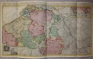
Novissima et Accuratissima Decem Austriacarum in Belgio Provinciarum Tabula
Publication Date: 1720
Seller: Kunstantiquariat Andreas Senger, Hamburg, Germany
Seller rating 5 out of 5 stars
Map
Kein Einband. Condition: Sehr gut. Es handelt sich hierbei um eine originale, altkolorierte Kupferstich-Landkarte der �sterreichischen Niederlande von Joachim Ottens, etwa aus dem Jahr 1720. *** Titel: Novissima et Accuratissima Decem Austriacarum in Belgio Provinciarum Tabula *** Gebiet bzw. Ort: Die �sterreichischen Niederlande, etwa dem Gebiet des heutigen Belgien und Luxemburg entsprechend *** Kartograph: Joachim Ottens (1663 - 1719) *** Jahr: um 1720 *** Gr��e des Plattenbereichs: 47 x 85 cm *** Technik: Kupferstich Zustand (Perfekt/ Sehr gut/ Gut/ Ordentlich/ M��ig/ Schlecht): In sehr gutem Erhaltungszustand *** Bemerkungen: Die rare und gro�formatige Karte zeigt sehr detailliert das Gebiet der �sterreichischen Niederlande, etwa dem Gebiet des heutigen Belgien und Luxemburg entsprechend. Diese sehr dekorative Karte ist altkoloriert und wurde von zwei Platten gedruckt. -- Die �sterreichischen Niederlande, (lateinisch Belgium Austriacum, niederl�ndisch Oostenrijkse Nederlanden, franz�sisch Pays-Bas autrichiens) umfassten in etwa das Gebiet der heutigen Staaten Belgien und Luxemburg und existierten vom Ende des Spanischen Erbfolgekrieges im Jahr 1714 bis zur Eroberung durch franz�sische Revolutionstruppen und den Anschluss an die Franz�sische Republik im Jahr 1795. (Wikipedia) *** English description: This large and magnificently detailed map of the Austrian Netherlands by Joachim Ottens shows a very fine and decorative depiction of the area around 1720. An interesting and desirable work in original colours that is rarely seen on the market. - - - International buyers welcome. If you have any questions, please don't hesitate to ask. --- Auf Wunsch stellen wir Ihnen gerne ein kostenfreies Echtheitszertifikat aus --- If you wish, we will gladly provide a certificate of authenticity free of charge ---.