

Order Total (1 Item Items):
Shipping Destination:

Robert Sayer John Bennett (31 results)
Skip to main search results
Search filters
Product Type
- All Product Types
- Books (13)
- Magazines & Periodicals (No further results match this refinement)
- Comics (No further results match this refinement)
- Sheet Music (No further results match this refinement)
- Art, Prints & Posters (15)
- Photographs (No further results match this refinement)
- Maps (3)
- Manuscripts & Paper Collectibles (No further results match this refinement)
Condition Learn more
- New (9)
- As New, Fine or Near Fine (1)
- Very Good or Good (2)
- Fair or Poor (No further results match this refinement)
- As Described (19)
Binding
Collectible Attributes
- First Edition (1)
- Signed (No further results match this refinement)
- Dust Jacket (1)
- Seller-Supplied Images (25)
- Not Print on Demand (24)
Language (2)
Free Shipping
Seller Location
Seller Rating
-

The American Military Pocket Atlas; Being an Approved Collection of Correct Maps, Both General and Particular; of the British Colonies; Especially Tho
Language: English
Published by Creative Media Partners, LLC Sep 2021, 2021
ISBN 10: 1014324955 ISBN 13: 9781014324955
Taschenbuch. Condition: Neu. Neuware.
-

The American Military Pocket Atlas; Being an Approved Collection of Correct Maps, Both General and Particular; of the British Colonies; Especially Tho
Language: English
Published by Creative Media Partners, LLC Jul 2023, 2023
ISBN 10: 1020516704 ISBN 13: 9781020516702
Buch. Condition: Neu. Neuware - This atlas provides a detailed and accurate look at the British colonies in North America, including maps of areas likely to see military action. It is an essential resource for military leaders, historians, and anyone interested in the history of the American Revolution.
-

The American Military Pocket Atlas; Being an Approved Collection of Correct Maps; Both General and Particular; of the British Colonies; Especially Those Which Now Are; or Probably May Be the Theatre o
Seller: Ria Christie Collections, Uxbridge, United Kingdom
Seller rating 5 out of 5 stars

US$ 16.01
US$ 16.12 shipping
Ships from United Kingdom to U.S.A.Quantity: Over 20 available
Add to basketCondition: New. PRINT ON DEMAND Book; New; Fast Shipping from the UK. No. book.
-

The American Military Pocket Atlas; Being an Approved Collection of Correct Maps, Both General and Particular; of the British Colonies; Especially Tho
Language: English
Published by Creative Media Partners, LLC, 2023
ISBN 10: 1020516704 ISBN 13: 9781020516702
HRD. Condition: New. New Book. Shipped from UK. THIS BOOK IS PRINTED ON DEMAND. Established seller since 2000.
-
The American Military Pocket Atlas; Being an Approved Collection of Correct Maps, Both General and Particular; of the British Colonies; Especially Those Which Now Are, or Probably May Be the Theatre of War; Taken Principally From the Actual Surveys And.
Seller: THE SAINT BOOKSTORE, Southport, United Kingdom
Seller rating 5 out of 5 stars
US$ 21.46
US$ 16.56 shipping
Ships from United Kingdom to U.S.A.Quantity: Over 20 available
Add to basketPaperback / softback. Condition: New. This item is printed on demand. New copy - Usually dispatched within 5-9 working days.
-
![Seller image for The American military pocket atlas; being an approved collection of correct maps, both general and particular; of the British colonies; especially those which now are, or probably may be the theatre of war; taken principally from the actual surveys and judicious observations of engineers De Brahm and Romans; Cook, Jackson, and Collet; 1776 [LeatherBound] for sale by True World of Books](https://pictures.abebooks.com/inventory/md/md31657234871.jpg)
LeatherBound. Condition: New. BOOKS ARE EXEMPT FROM IMPORT DUTIES AND TARIFFS; NO EXTRA CHARGES APPLY. LeatherBound edition. Condition: New. Reprinted from 1776 edition. Leather Binding on Spine and Corners with Golden leaf printing on spine. Bound in genuine leather with Satin ribbon page markers and Spine with raised gilt bands. A perfect gift for your loved ones. Pages: 35 NO changes have been made to the original text. This is NOT a retyped or an ocr'd reprint. Illustrations, Index, if any, are included in black and white. Each page is checked manually before printing. As this print on demand book is reprinted from a very old book, there could be some missing or flawed pages, but we always try to make the book as complete as possible. Fold-outs, if any, are not part of the book. If the original book was published in multiple volumes then this reprint is of only one volume, not the whole set. Sewing binding for longer life, where the book block is actually sewn (smythe sewn/section sewn) with thread before binding which results in a more durable type of binding. Pages: 35 Robert Sayer and John Bennett (Firm).
-
The American Military Pocket Atlas; Being an Approved Collection of Correct Maps, Both General and Particular; of the British Colonies; Especially Those Which Now Are, or Probably May Be the Theatre of War; Taken Principally From the Actual Surveys And.
Seller: THE SAINT BOOKSTORE, Southport, United Kingdom
Seller rating 5 out of 5 stars
US$ 39.58
US$ 17.52 shipping
Ships from United Kingdom to U.S.A.Quantity: Over 20 available
Add to basketHardback. Condition: New. This item is printed on demand. New copy - Usually dispatched within 5-9 working days.
-

A Chart of the Nicobar Islands
Published by London, 1778
Seller: Clive A. Burden Ltd., Chalfont St. Giles, BUCKS, United Kingdom
Seller rating 5 out of 5 stars
Map
US$ 311.82
US$ 29.80 shipping
Ships from United Kingdom to U.S.A.Quantity: 1 available
Add to basketNo binding. 540 x 370 mm., in fine early wash colour and in good condition. Robert Sayer was active from 1745 and was joined in partnership by John Bennett in 1774. Their early works were derived from maps acquired from the late Thomas Jefferys. One of their most significant productions was the 'East India Pilot' which was advertised in 1775 as being 'in great forwardness for publication'. This chart of the Nicobar Islands bears an inset of "A particular Plan of the Harbour Comprized between the Isles Nacaveri, Souri & Tricutte". Shirley BL Atlases M.Say-3a no. 62; NMM 417 no. 29.
-
The American Military Pocket Atlas; being an approved collection of correct maps, both general and particular, of the British Colonies; especially those which now are, or probably may be the Theatre of War: Taken principally from the actual surveys and judicious observations of engineers De Brahm and Romans; Cook, Jackson, and Collett; Maj. Holland, and other officers
Published by Printed for R. Sayer and J. Bennett, London, 1776
Seller: James Cummins Bookseller, ABAA, New York, NY, U.S.A.
Seller rating 5 out of 5 stars
Titlepage, 2pp. dedication to "Gov. Pownall," 2pp. "Advertisement," 1p. "List of maps"; and six folding engraved maps, all hand-colored in outline. The "Holster Atlas" was issued at the suggestion of Gov. George Pownall and included the "maps that the British high command regarded as providing essential topographical information in the most convenient form" (Schwartz & Ehrenberg). This collection of maps was published by Sayer and Bennet at the beginning of the Revolution for the use of British officers. "Surveys and Topographical Charts being fit only for a Library, such maps as an Officer may take with him into the Field have been much wanted. The following Collection forms a Portable Atlas of North America, calculated in its Bulk and Price to suit the Pockets of Officers of all Ranks" (Advertisement). Although the publishers claimed the atlas would fit into an officer's pocket, it was more usually carried in a holster and thus gained its nickname. The six maps are as follows: 1) Dunn, Samuel: North America, as divided amongst the European Powers. London: printed for Robt. Sayer, Jan. 10, 1774. Engraved map, handcolored in outline, 13¾ x 19 inches. 2) Dunn, Samuel A Compleat Map of the West Indies, containing the coasts of Florida, Louisiana, New Spain and Terra Firma: with all the islands. London: Robt. Sayer, Jan. 10, 1774. Engraved map, handcolored in outline (14 x 19 inches). 3) A General Map of the Northern British Colonbies in America. Which comprehends the Province of Quebec, the Government of Newfoundland, Nova-Scotia, New-England and New York. From the Maps Published by the Admiralty and Board of Trade, regulated by the Astronomic and Trionometric Observations of Major Holland and Corrected from Governor Pownall's Late Map of 1776. London: Robt. Sayer & Jno. Bennet, Aug. 14, 1776. Engraved map, handcolored in outline (20 x 27¾ inches). First state. McCorkle 776.11; Sellers & Van Ee 143; Stevens & Tree 65. 4) Evans, Lewis: A General Map of the Middle British Colonies in America. Containing Virginia, Maryland, the Delaware Counties, Pennsylvania and New Jersey. With the addition of New York, and the greatest part of New England, as also of the bordering parts of the Province of Quebec, improved from several surveys made after the late war, and corrected from Governor Pownall's late map 1776. London: R. Sayer & J. Bennet, Oct. 15, 1776. Engraved map, handcolored in outline (20¼ x 28 inches). Stephenson & McKee, Virginia, p.82. 5) Romans, Bernard: A General Map of the Southern British Colonies in America. Comprehending North and South Carolina, Georgia, East and West Florida, with the Neighboring Indian Countries. From the Modern Surveys of Engineer De Brahm, Capt. Collet, Mouzon & others; and from the large Hydrographical Survey of the Coasts of East and West Florida by B. Romans. London: R. Sayer & J. Bennett [sic], Oct. 15, 1776. Engraved map, handcolored in outline (20¾ x 27 inches). 6) Brassier, William Furness: A Survey of Lake Champlain including Lake George, Crown Point and St. John, Surveyed by order of . Sr. Jeffery Amherset . by William Brassier, Draughtsman. 1762. London: Robt. Sayer & Jno. Bennet, Aug. 5, 1776. Engraved map, handcolored (28 x 20½ inches). Also issued as the first separately published map of Lake Champlain, this excellent detailed chart was based on a survey made during the French and Indian War, but not published until the Revolution. The map was issued in two states and is included here in its appropriate (and preferred) second state, illustrating the very first battle fought by the U.S. Navy: the Battle of Valcour Island, which transpired near present-day Plattsburgh, New York. Also included is an inset illustrating America's first naval battle, in which General Benedict Arnold, though forced back down the lake, was able to delay the British attempt to descend to the Hudson for that year. No mention, of course, is made of Ethan Allen's taking of Fort Ticonderoga in 1775. An important collection of Revolutionary-era American maps. Fite & Freeman, A Book of Old Maps, pp.212-16; Howes A208; Nebenzahl, Atlas of the American Revolution, pp.61-63; Phillips Atlases 1206; Rumsey, p.311. Sabin 1147; Schwartz & Ehrenberg, p.190. Streeter Sale 73; Clark I:189; Reese, Revolutionary Hundred 45 Contemporary calf-backed marbled paper covered boards, some wear with minor losses to leather and marbled paper. Cellotape stains at folds of the final three maps, minor separations at some folds. Provenance: John Suetterle Taylor Titlepage, 2pp. dedication to "Gov. Pownall," 2pp. "Advertisement," 1p. "List of maps"; and six folding engraved maps, all hand-colored in outline.
-

American Military Pocket Atlas; being an approved collection of
Seller: G.S. MacManus Co., ABAA, Bryn Mawr, PA, U.S.A.
Seller rating 5 out of 5 stars
(AMERICAN REVOLUTION). SAYER, Robert; BENNETT, John. The American Military Pocket Atlas; being an approved collection of correct maps, both general and particular, of the British Colonies; especially those which now are, or probably may be the Theatre of War: Taken principally from the actual surveys and judicious observations of engineers De Brahm and Romans; Cook, Jackson, and Collett; Maj. Holland, and other officers. Titlepage, 2pp. dedication to "Gov. Pownall," 2pp. "Advertisement," 1p. "List of maps"; and six folding engraved maps, all hand-colored in outline. London: Printed for R. Sayer and J. Bennett, [1776]. Contemporary calf-backed marbled paper covered boards, some wear with minor losses to leather and marbled paper. Cellotape stains at folds of the final three maps, minor separations at some folds. Provenance: John Suetterle Taylor. Fite & Freeman, A Book of Old Maps, pp.212-16; Howes A208; Nebenzahl, Atlas of the American Revolution, pp.61-63; Phillips Atlases 1206; Rumsey, p.311. Sabin 1147; Schwartz & Ehrenberg, p.190. Streeter Sale 73; Clark I:189; Reese, Revolutionary Hundred 45. The "Holster Atlas" was issued at the suggestion of Gov. George Pownall and included the "maps that the British high command regarded as providing essential topographical information in the most convenient form" (Schwartz & Ehrenberg). This collection of maps was published by Sayer and Bennet at the beginning of the Revolution for the use of British officers. "Surveys and Topographical Charts being fit only for a Library, such maps as an Officer may take with him into the Field have been much wanted. The following Collection forms a Portable Atlas of North America, calculated in its Bulk and Price to suit the Pockets of Officers of all Ranks" (Advertisement). Although the publishers claimed the atlas would fit into an officer's pocket, it was more usually carried in a holster and thus gained its nickname. The six maps are as follows: 1) Dunn, Samuel: North America, as divided amongst the European Powers. London: printed for Robt. Sayer, Jan. 10, 1774. Engraved map, handcolored in outline, 13_ x 19 inches. 2) Dunn, Samuel A Compleat Map of the West Indies, containing the coasts of Florida, Louisiana, New Spain and Terra Firma: with all the islands. London: Robt. S.
-
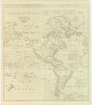
A Chart of North and South America, Including the Atlantic and Pacific Oceans, with the nearest Coasts of Europe, Africa, and Asia
Published by London, 1775
Seller: Neatline Antique Maps, Tiburon, CA, U.S.A.
Seller rating 4 out of 5 stars

Map
No Binding. Condition: Very Good. Sayer-Bennet-Mead s 1775 detailed chart of the Western Hemisphere with Pacific and Arctic routes of exploration. Details Key points: 1. Braddock Mead s A Chart of North and South America encapsulates the finest qualities of mapmaking in the second half of the 18th century, presenting a remarkable wealth of information. 2. The map was first issued in 1753, and one of its most important features was a repudiation of ideas put forth in an influential 1752 map by French mapmakers De L Isle and Buache. 3. Our issue was published in 1775 and the revisions are a fascinating mix of improved geography (e.g. the great rivers of North America), and new cartographic myths, (e.g. the rendition of Alaska as an island). 4. The map is also interesting from a political perspective, being a bold statement of Great Britain s North American territorial claims the irony of course being that the map was published in the earliest days of the Revolutionary War. Neatline is famous for its detailed and in-depth descriptions. To receive the full description for this listing free of charge, please contact us using the 'ask the seller' function below.
-
![Seller image for [Untitled Chart of 'Goonong Appee', 'Banda Veira' and 'Banda.] for sale by Maggs Bros. Ltd ABA, ILAB, PBFA](https://pictures.abebooks.com/inventory/md/md30971892920.jpg)
[Untitled Chart of 'Goonong Appee', 'Banda Veira' and 'Banda.]
Published by 1778]., 1778
Seller: Maggs Bros. Ltd ABA, ILAB, PBFA, London, United Kingdom
Association Member: ABA ILAB PBFA
Seller rating 5 out of 5 stars
Art / Print / Poster
US$ 1,039.39
US$ 36.33 shipping
Ships from United Kingdom to U.S.A.Quantity: 1 available
Add to basketCopper engraving, 400 x 500 mm. [London : Robert Sayer & John Bennett, 20 April, Unsigned chart of Banda, apparently from Sayer and Bennett's Oriental Navigator ., their extensive pilot book of the route from England to the Far East. Although not present in Shirley's collation of the British Library copy of the atlas, this example has the Sayer and Bennett chart of Subec Bay offset on the verso.
-

The American Military Pocket Atlas; being An approved Collection of Correct Maps, both general and particular, of the British Colonies; Especially those which now are, or probably may be The Theatre of War: Taken principally from the actual Surveys and judicious Observations of Engineers De Brahm and Römans; Cook, Jackson, and Collet;; Maj. Holland, and Other Officers, Employed in His Majesty's Fleets and Armies.
Publication Date: 1776
Seller: Altea Antique Maps, London, United Kingdom
Association Member: ABA ILAB PBFA
Seller rating 5 out of 5 stars
US$ 22,173.67
US$ 47.09 shipping
Ships from United Kingdom to U.S.A.Quantity: 1 available
Add to basketHardcover. Condition: Fine. London: Sayer & Bennett, 1776. 8vo, contemporary marbled boards rebacked with calf gilt with maroon calf title label; title, pp. vi-viii (dedication letter and Advertisement + list of maps; with six folding engraved maps with original outline colour, as called for. A very fine example of the rare 'Holster Atlas', ''calculated in its bulk to suit the pockets of Officers of all Ranks''. The atlas was created on the suggestion of Sir George Pownall, Governor of Massachusetts 1757-60, to whom it is dedicated; two of the maps are based on his work. The six maps it contains are regarded as particularly important to the mapping of the American Revolution because they represent the knowledge of the terrain the British based their strategies on. The final map is the first separately published map of Lake Champlain. The maps are: ''North America, as Divided amongst the European Powers. By Samuel Dunn, Mathematician''; ''A Compleat Map of the West Indies, containing the Coasts of Florida, Louisiana, New Spain, and Terra Firma: with all the Islands. By Samuel Dunn, Mathematician ''; ''A General Map of the Middle British Colonies, in America. Containing Virginia, Maryland, the Delaware Counties, Pennsylvania and New Jersey. With the addition of New York, and of the Greatest Part of New England, as also of the Bordering Parts of the Province of Quebec, improved from several Surveys made after the late War, and Corrected from Governor Pownall's Late Map 1776''; ''A General Map of the Southern British Colonies, in America. Comprehending North and South Carolina, Georgia, East and West Florida, with the Neighbouring Indian Countries. From the Modern Surveys of Engineer de Brahm, Capt. Collet, Mouzon & Others; and from the Large Hydrographical Survey of the Coasts of East and West Florida. By B. Romans, 1776''; and ''A Survey of Lake Champlain, including Lake George, Crown Point and St. John. Surveyed by Order of His Excellency Major General S.r Jeffery Amherst, Knight of the most Hon.ble Order of the Bath, Commander in Chief of His Majesty's Forces in North America, (now Lord Amherst) by William Brassier, Draughtsman. 1762''. The pagination anomalies are replicated in other examples of the atlas we have examined.
-
The Theatre of War in North America, with the roads and a table of distances./A compendious account of the British Colonies in North -America ./Evan's polymetric table of America.
Published by London, 1776
Seller: Arader Galleries of Philadelphia, PA, Philadelphia, PA, U.S.A.
Seller rating 4 out of 5 stars
N/A. Condition: Very Good. Dust Jacket Condition: N/A. Broadside sheet with outline color. Sheet size: 29 x 21 1/2". Inventory#: p211pmat. A highly important Revolutionary War map published early in 1776 and sold in London for a shilling. Its purpose was to give the British public an overview of the colonies in which the conflict was developing. The map occupies the upper portion, with the colonies described in letterpress below. Inset on the map is a table of distances which must have been enlightening to the English who imagined the colonies to be much smaller and closer together.
-
![Seller image for Several Appearances of the Agoada Fort near the Island of Goa on the Coast of Malabar [&] Several Appearances of Hogg Island on the Western Coast of Sumatra. for sale by Maggs Bros. Ltd ABA, ILAB, PBFA](https://pictures.abebooks.com/inventory/md/md30971889131.jpg)
Several Appearances of the Agoada Fort near the Island of Goa on the Coast of Malabar [&] Several Appearances of Hogg Island on the Western Coast of Sumatra.
Publication Date: 1778
Seller: Maggs Bros. Ltd ABA, ILAB, PBFA, London, United Kingdom
Association Member: ABA ILAB PBFA
Seller rating 5 out of 5 stars
Art / Print / Poster
US$ 149.67
US$ 36.33 shipping
Ships from United Kingdom to U.S.A.Quantity: 1 available
Add to basketCopper engraving, 451 x 330 mm. London : Robert Sayer & John Bennett, 20 April, From an early edition of Sayer and Bennett's Oriental Navigator ., their extensive pilot book of the route from England to the Far East, including coverage of the east coast of Africa, Arabia, Persia, the Indian sub-continent, South-East Asia and the East Indies and on to the Far East, with China and Japan. This is a single sheet of coastal recognition profiles.
-
Leather Bound. Condition: New. Language: English. Language: English. Presenting an Exquisite Leather-Bound Edition, expertly crafted with Original Natural Leather that gracefully adorns the spine and corners. The allure continues with Golden Leaf Printing that adds a touch of elegance, while Hand Embossing on the rounded spine lends an artistic flair. This masterpiece has been meticulously reprinted in 2024, utilizing the invaluable guidance of the original edition published many years ago in 1775. The contents of this book are presented in classic black and white. Its durability is ensured through a meticulous sewing binding technique, enhancing its longevity. Imprinted on top-tier quality paper. A team of professionals has expertly processed each page, delicately preserving its content without alteration. Due to the vintage nature of these books, every page has been manually restored for legibility. However, in certain instances, occasional blurriness, missing segments, or faint black spots might persist. We sincerely hope for your understanding of the challenges we faced with these books. Recognizing their significance for readers seeking insight into our historical treasure, we've diligently restored and reissued them. Our intention is to offer this valuable resource once again. We eagerly await your feedback, hoping that you'll find it appealing and will generously share your thoughts and recommendations. Lang: - English, Pages: : - 130, Print on Demand. If it is a multi-volume set, then it is only a single volume. We are specialised in Customisation of books, if you wish to opt different color leather binding, you may contact us. This service is chargeable. Product Disclaimer: Kindly be informed that, owing to the inherent nature of leather as a natural material, minor discolorations or textural variations may be perceptible. Explore the FOLIO EDITION (12x19 Inches): Available Upon Request. 130 130.
-
Leather Bound. Condition: New. Language: English. Language: English. Presenting an Exquisite Leather-Bound Edition, expertly crafted with Original Natural Leather that gracefully adorns the spine and corners. The allure continues with Golden Leaf Printing that adds a touch of elegance, while Hand Embossing on the rounded spine lends an artistic flair. This masterpiece has been meticulously reprinted in 2024, utilizing the invaluable guidance of the original edition published many years ago in 1794. The contents of this book are presented in classic black and white. Its durability is ensured through a meticulous sewing binding technique, enhancing its longevity. Imprinted on top-tier quality paper. A team of professionals has expertly processed each page, delicately preserving its content without alteration. Due to the vintage nature of these books, every page has been manually restored for legibility. However, in certain instances, occasional blurriness, missing segments, or faint black spots might persist. We sincerely hope for your understanding of the challenges we faced with these books. Recognizing their significance for readers seeking insight into our historical treasure, we've diligently restored and reissued them. Our intention is to offer this valuable resource once again. We eagerly await your feedback, hoping that you'll find it appealing and will generously share your thoughts and recommendations. Lang: - English, Pages: : - 164, Print on Demand. If it is a multi-volume set, then it is only a single volume. We are specialised in Customisation of books, if you wish to opt different color leather binding, you may contact us. This service is chargeable. Product Disclaimer: Kindly be informed that, owing to the inherent nature of leather as a natural material, minor discolorations or textural variations may be perceptible. Explore the FOLIO EDITION (12x19 Inches): Available Upon Request. 164 164.
-
![Seller image for A Chart of Part of the Coast of Cochinchina, from Cham-Collao Island to the Kings River Mr Mr. le Floche de la Carriere . [&] Plan of Pulo Condor . for sale by Maggs Bros. Ltd ABA, ILAB, PBFA](https://pictures.abebooks.com/inventory/md/md30971890013.jpg)
A Chart of Part of the Coast of Cochinchina, from Cham-Collao Island to the Kings River Mr Mr. le Floche de la Carriere . [&] Plan of Pulo Condor .
Publication Date: 1778
Seller: Maggs Bros. Ltd ABA, ILAB, PBFA, London, United Kingdom
Association Member: ABA ILAB PBFA
Seller rating 5 out of 5 stars
Art / Print / Poster
US$ 449.02
US$ 36.33 shipping
Ships from United Kingdom to U.S.A.Quantity: 1 available
Add to basketCopper engraving, 475 x 335 mm. London : Robert Sayer & John Bennett, 20 April, From an early edition of Sayer and Bennett's Oriental Navigator ., their extensive pilot book of the route from England to the Far East, including coverage of the east coast of Africa, Arabia, Persia, the Indian sub-continent, South-East Asia and the East Indies and on to the Far East, with China and Japan. .
-

A New Plan of the Strait situated to the East of Java & Madura commonly called the Straits of Bali and of Pondi and Respondi .
Publication Date: 1778
Seller: Maggs Bros. Ltd ABA, ILAB, PBFA, London, United Kingdom
Association Member: ABA ILAB PBFA
Seller rating 5 out of 5 stars
Art / Print / Poster
US$ 449.02
US$ 36.33 shipping
Ships from United Kingdom to U.S.A.Quantity: 1 available
Add to basketCopper engraving, 490 x 300 mm. London : Robert Sayer & John Bennett, 20 April, From an early edition of Sayer and Bennett's Oriental Navigator ., their extensive pilot book of the route from England to the Far East, including coverage of the east coast of Africa, Arabia, Persia, the Indian sub-continent, South-East Asia and the East Indies and on to the Far East, with China and Japan. With an insert of 'The Bay of Ballambouang survey'd on board the Royal George 1766'.
-

Plan of the Port of Rhio on the Island of Bintang in the Straits of Sincapore .from A Draught published by Mr. d'Apres de Mannevillette Compared with a French Manuscript communicated by Mr. Dodwell.
Publication Date: 1778
Seller: Maggs Bros. Ltd ABA, ILAB, PBFA, London, United Kingdom
Association Member: ABA ILAB PBFA
Seller rating 5 out of 5 stars
Art / Print / Poster
US$ 449.02
US$ 36.33 shipping
Ships from United Kingdom to U.S.A.Quantity: 1 available
Add to basketCopper engraving, 515 x 404 mm. London : Robert Sayer & John Bennett, 20 April, From an early edition of Sayer and Bennett's Oriental Navigator ., their extensive pilot book of the route from England to the Far East, including coverage of the east coast of Africa, Arabia, Persia, the Indian sub-continent, South-East Asia and the East Indies and on to the Far East, with China and Japan. .
-

A Chart of the Nicobar Islands in the Gulf of Bengal, from Mr. d'Apres de Mannevillette.
Publication Date: 1778
Seller: Maggs Bros. Ltd ABA, ILAB, PBFA, London, United Kingdom
Association Member: ABA ILAB PBFA
Seller rating 5 out of 5 stars
Art / Print / Poster
US$ 449.02
US$ 36.33 shipping
Ships from United Kingdom to U.S.A.Quantity: 1 available
Add to basketCopper engraving, 460 x 300 mm. London : Robert Sayer & John Bennett, 20 April, From an early edition of Sayer and Bennett's Oriental Navigator ., their extensive pilot book of the route from England to the Far East, including coverage of the east coast of Africa, Arabia, Persia, the Indian sub-continent, South-East Asia and the East Indies and on to the Far East, with China and Japan. .
-

A Chart of the Eastern Coast of the Gulf of Bengal from Mr. D'Apres de Mannevillette.
Publication Date: 1778
Seller: Maggs Bros. Ltd ABA, ILAB, PBFA, London, United Kingdom
Association Member: ABA ILAB PBFA
Seller rating 5 out of 5 stars
Map
US$ 523.85
US$ 36.33 shipping
Ships from United Kingdom to U.S.A.Quantity: 1 available
Add to basketCopper engraving, 480 x 327 mm. London : Robert Sayer & John Bennett, 20 April, From an early edition of Sayer and Bennett's Oriental Navigator ., their extensive pilot book of the route from England to the Far East, including coverage of the east coast of Africa, Arabia, Persia, the Indian sub-continent, South-East Asia and the East Indies and on to the Far East, with China and Japan. .
-

The Coast of India, from Guadavery Point to the Ganges, comprehending part of the coast of the Five Circars, the Coasts of Orissa and Bengal, with the Mouth of the Ganges.
Publication Date: 1778
Seller: Maggs Bros. Ltd ABA, ILAB, PBFA, London, United Kingdom
Association Member: ABA ILAB PBFA
Seller rating 5 out of 5 stars
Art / Print / Poster
US$ 538.81
US$ 36.33 shipping
Ships from United Kingdom to U.S.A.Quantity: 1 available
Add to basketCopper engraving, 451 x 600 mm. London : Robert Sayer & John Bennett, 20 April, From an early edition of Sayer and Bennett's Oriental Navigator ., their extensive pilot book of the route from England to the Far East, including coverage of the east coast of Africa, Arabia, Persia, the Indian sub-continent, South-East Asia and the East Indies and on to the Far East, with China and Japan. .
-
![Seller image for The Road of Palleacate off the coast of Coromandell [&] The road of Tengepatnam or Fort St. David on the Coast of Coromomadel from van Keulen. for sale by Maggs Bros. Ltd ABA, ILAB, PBFA](https://pictures.abebooks.com/inventory/md/md30971885492.jpg)
The Road of Palleacate off the coast of Coromandell [&] The road of Tengepatnam or Fort St. David on the Coast of Coromomadel from van Keulen.
Publication Date: 1778
Seller: Maggs Bros. Ltd ABA, ILAB, PBFA, London, United Kingdom
Association Member: ABA ILAB PBFA
Seller rating 5 out of 5 stars
Art / Print / Poster
US$ 538.81
US$ 36.33 shipping
Ships from United Kingdom to U.S.A.Quantity: 1 available
Add to basketCopper engraving, two maps on one sheet, totalling 512 x 225 mm. The margins lightly soiled. London : Robert Sayer & John Bennett, 20 April, From an early edition of Sayer and Bennett's Oriental Navigator ., their extensive pilot book of the route from England to the Far East, including coverage of the east coast of Africa, Arabia, Persia, the Indian sub-continent, South-East Asia and the East Indies and on to the Far East, with China and Japan. .
-
![Seller image for Plan of Solsogon Harbour on the South Coast of Luconia from Murillo. [&] Chart of the Eastern Coast of Bongo Bay in the Island of Mindanao, from van Keulen. for sale by Maggs Bros. Ltd ABA, ILAB, PBFA](https://pictures.abebooks.com/inventory/md/md30971889129.jpg)
Plan of Solsogon Harbour on the South Coast of Luconia from Murillo. [&] Chart of the Eastern Coast of Bongo Bay in the Island of Mindanao, from van Keulen.
Publication Date: 1778
Seller: Maggs Bros. Ltd ABA, ILAB, PBFA, London, United Kingdom
Association Member: ABA ILAB PBFA
Seller rating 5 out of 5 stars
Art / Print / Poster
US$ 727.57
US$ 36.33 shipping
Ships from United Kingdom to U.S.A.Quantity: 1 available
Add to basketCopper engraving, 485 x 235 mm. London : Robert Sayer & John Bennett, 20 April, From an early edition of Sayer and Bennett's Oriental Navigator ., their extensive pilot book of the route from England to the Far East, including coverage of the east coast of Africa, Arabia, Persia, the Indian sub-continent, South-East Asia and the East Indies and on to the Far East, with China and Japan. .
-

A Chart of the North-West Coast of Borneo from Balambangan to Borneo proper Survey'd in the Sloop Endeavour by James Barton.
Publication Date: 1778
Seller: Maggs Bros. Ltd ABA, ILAB, PBFA, London, United Kingdom
Association Member: ABA ILAB PBFA
Seller rating 5 out of 5 stars
Art / Print / Poster
US$ 4,157.56
US$ 36.33 shipping
Ships from United Kingdom to U.S.A.Quantity: 1 available
Add to basketCopper engraving, 515 x 460 mm. London : Robert Sayer & John Bennett, 20 April, From an early edition of Sayer and Bennett's Oriental Navigator ., their extensive pilot book of the route from England to the Far East, including coverage of the east coast of Africa, Arabia, Persia, the Indian sub-continent, South-East Asia and the East Indies and on to the Far East, with China and Japan. This chart was added to the 1781, second, edition of the Oriental Navigator.
-

The Coast of India and China from the Point and River of Camboia to Canton comprehending the Coasts of Tsiompa and Cochin China, and the Coast of Tonkin, and the Coast of Koan-Ton, with the Isle of Hai-nan by Capt. John Haldane.
Publication Date: 1780
Seller: Maggs Bros. Ltd ABA, ILAB, PBFA, London, United Kingdom
Association Member: ABA ILAB PBFA
Seller rating 5 out of 5 stars
Art / Print / Poster
US$ 5,543.42
US$ 36.33 shipping
Ships from United Kingdom to U.S.A.Quantity: 1 available
Add to basketCopper engraving, 595 x 445 mm. London : Robert Sayer & John Bennett, 28 Octr. From an early edition of Sayer and Bennett's Oriental Navigator ., their extensive pilot book of the route from England to the Far East, including coverage of the east coast of Africa, Arabia, Persia, the Indian sub-continent, South-East Asia and the East Indies and on to the Far East, with China and Japan. A new chart, added to the Second Edition. Includes the Hong Kong area and Macao.
-

A Chart of the Braces at the Entrance of the Ganges or River of Hughly with the Course of that River up to the Town of Hughly, improved from Mr. D'Anville's Chart .
Publication Date: 1778
Seller: Maggs Bros. Ltd ABA, ILAB, PBFA, London, United Kingdom
Association Member: ABA ILAB PBFA
Seller rating 5 out of 5 stars
Art / Print / Poster
US$ 1,039.39
US$ 36.33 shipping
Ships from United Kingdom to U.S.A.Quantity: 1 available
Add to basketCopper engraving, 602 x 443 mm. The margins lightly soiled. London : Robert Sayer & John Bennett, 20 April, From an early edition of Sayer and Bennett's Oriental Navigator ., their extensive pilot book of the route from England to the Far East, including coverage of the east coast of Africa, Arabia, Persia, the Indian sub-continent, South-East Asia and the East Indies and on to the Far East, with China and Japan. .
-

Plan of the Port of Subec, in the Isle of Luconia survey'd in the Year 1766 .
Publication Date: 1778
Seller: Maggs Bros. Ltd ABA, ILAB, PBFA, London, United Kingdom
Association Member: ABA ILAB PBFA
Seller rating 5 out of 5 stars
Art / Print / Poster
US$ 1,108.68
US$ 36.33 shipping
Ships from United Kingdom to U.S.A.Quantity: 1 available
Add to basketCopper engraving, 475 x 330 mm. London : Robert Sayer & John Bennett, 20 April, From an early edition of Sayer and Bennett's Oriental Navigator ., their extensive pilot book of the route from England to the Far East, including coverage of the east coast of Africa, Arabia, Persia, the Indian sub-continent, South-East Asia and the East Indies and on to the Far East, with China and Japan. .
-

The Coast of India, between Callminera and Guadavery Points, comprehending the Coast of Coromandel, with part of the Coast of the Five Circars.
Publication Date: 1778
Seller: Maggs Bros. Ltd ABA, ILAB, PBFA, London, United Kingdom
Association Member: ABA ILAB PBFA
Seller rating 5 out of 5 stars
Art / Print / Poster
US$ 727.57
US$ 36.33 shipping
Ships from United Kingdom to U.S.A.Quantity: 1 available
Add to basketCopper engraving, 597 x 442 mm. The margins lightly soiled. London : Robert Sayer & John Bennett, 20 April, From an early edition of Sayer and Bennett's Oriental Navigator ., their extensive pilot book of the route from England to the Far East, including coverage of the east coast of Africa, Arabia, Persia, the Indian sub-continent, South-East Asia and the East Indies and on to the Far East, with China and Japan. .


![Seller image for Geographia antiqua delineata ; or, Antient geography, exhibited in a set of thirty-one maps comprehending all the several states of Greece, and the numerous parts of the Roman Empire, contained in the Greek and Latin classics . to which is added, a map of the places mentioned in the Old and New Testament . [cartographic material] 1775 [Leather Bound] for sale by Gyan Books Pvt. Ltd.](https://pictures.abebooks.com/inventory/md/md31423754076.jpg)
![Seller image for All draughtsmen's assistant, or, Drawing made easy : wherein the principles of that art are rendered familiar in ten instructive lessons comprised under the following heads : l. features and limbs, 2. profiles and ovals, 3. whole figures, 4. drapery, 5. light and shade, 6. landscapes, 7. perspective, 8. enlarging and contracting, 9. imitation of life, 10. history : explained by a great variety of examples from the most approved designs on copper-plates, neatly engraved : with a suitable introduction on the utility of this noble art and observations on design as well in regard to theory as practice 1794 [Leather Bound] for sale by Gyan Books Pvt. Ltd.](https://pictures.abebooks.com/inventory/md/md31423792666.jpg)