Order Total (1 Item Items):
Shipping Destination:

Tassin Nicholas (8 results)
Skip to main search results
Search filters
Product Type
- All Product Types
- Books (6)
- Magazines & Periodicals (No further results match this refinement)
- Comics (No further results match this refinement)
- Sheet Music (No further results match this refinement)
- Art, Prints & Posters (2)
- Photographs (No further results match this refinement)
- Maps (No further results match this refinement)
- Manuscripts & Paper Collectibles (No further results match this refinement)
Condition Learn more
- New (No further results match this refinement)
- As New, Fine or Near Fine (4)
- Very Good or Good (2)
- Fair or Poor (No further results match this refinement)
- As Described (2)
Binding
Collectible Attributes
- First Edition (1)
- Signed (No further results match this refinement)
- Dust Jacket (No further results match this refinement)
- Seller-Supplied Images (7)
- Not Print on Demand (8)
Language (1)
Price
- Any Price
- Under US$ 25 (No further results match this refinement)
- US$ 25 to US$ 50
- Over US$ 50
Free Shipping
Seller Location
Seller Rating
-
Hand Colored 1636 Print, Map of St Iean de lauen [St Jean delaune], from 'Les plans et profils de toutes les principales villes et lieux considerables de France
Published by [Tavernier], 1636
Seller: Yesterday's Muse, ABAA, ILAB, IOBA, Webster, NY, U.S.A.
Association Member: ABAA ILAB IOBA
Seller rating 5 out of 5 stars

Print. Condition: Near Fine. Matted and ready for framing. Untrimmed. An exceptional example of a scarce print. A 7 x 9 3/4 sheet professionally matted down to 4 3/4 x 6 3/4 (mat measures 8 1/2 x 10 5/8). Beautiful modern hand coloring added. Labeled 20 in the upper right-hand corner. The print shows a fortification positioned on the north side of a natural waterway, with a small fortification on the opposite side as well. A bridge links the main fortification to the opposite shore, and there appears to be an area for entry by boat along the south wall. This fortress is unique in being completely surrounded by water - the river water acts as a moat between the inner and outer curtains, and also as a moat outside the outer curtain. The only land entries are the south bridge gate and a northern gate that passes through the outer curtain. The shapes of the walls illustrate the star-shaped patterns common to this era, an adaptation made to allow for defensive canonry, and to protect against siege artillery.
-
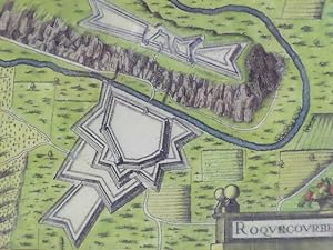
Hand Colored 1636 Print, Map of Roquecourbe, from 'Les plans et profils de toutes les principales villes et lieux considerables de France
Published by [Tavernier], 1636
Seller: Yesterday's Muse, ABAA, ILAB, IOBA, Webster, NY, U.S.A.
Association Member: ABAA ILAB IOBA
Seller rating 5 out of 5 stars
Print. Condition: Near Fine. Matted and ready for framing. Untrimmed. An exceptional example of a scarce print. A 7 x 9 3/4 sheet professionally matted down to 4 3/4 x 6 3/4 (mat measures 8 1/2 x 10 5/8). Beautiful modern hand coloring added. Labeled 44 in the upper right-hand corner. Roquecourbe is a region in south central France. The print shows a unique two-part fortification positioned on both sides of a natural waterway. The larger part borders on the south, with a bridge gatehouse leading to the main road. The northern portion sits atop a plateau linked to the main road by a winding stair. Attacking forces attempting to storm the main gate would be caught in a pincer attack between the two fortresses. The limited space between river and plateau would put them at even more severe a disadvantage by reducing troops to a narrow column. The shapes of the walls illustrate the star-shaped patterns common to this era, an adaptation made to allow for defensive canonry, and to protect against siege artillery.
-
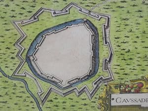
Hand Colored 1636 Print, Map of Caussade, from 'Les plans et profils de toutes les principales villes et lieux considerables de France
Published by [Tavernier], 1636
Seller: Yesterday's Muse, ABAA, ILAB, IOBA, Webster, NY, U.S.A.
Association Member: ABAA ILAB IOBA
Seller rating 5 out of 5 stars
Print. Condition: Near Fine. Matted and ready for framing. Untrimmed. An exceptional example of a scarce print. A 7 x 9 3/4 sheet professionally matted down to 4 3/4 x 6 3/4 (mat measures 8 1/2 x 10 5/8). Beautiful modern hand coloring added. Labeled 15 in the upper right-hand corner. Caussade is a region in southwestern France. The print shows a fortification positioned along a waterway which runs northwest to southeast along the southwest wall. The only entrance is at the northeast corner. There are two curtain walls, the inner one surrounded by a moat. The shapes of the walls illustrate the star-shaped patterns common to this era, an adaptation made to allow for defensive canonry, and to protect against siege artillery.
-
Cartes generale et particulieres de toutes les costes de France, tant de la mer Oceane que Mediterranee
Published by Paris, Michel Vanlochom, 1634
Seller: Librairie de l'Avenue - Henri Veyrier, Saint-Ouen, FR, France
Seller rating 4 out of 5 stars

Couverture souple. Condition: Bon �tat. In-4 � l'italienne 26,5 x 39 cm. Reliure plein v�lin souple de l'�poque, titre manuscrit, 2 ff.- 14 pp. & 32 planches dont 2 de titre grav�, une carte g�n�rale repli�e restauration sans manque et 29 cartes particuli�res une infime restauration. Texte sur deux colonnes latin et fran�ais en regard. Marges brunies. Humidit� marginale �parse. Ex-libris Prosper Falgairolle. Bon exemplaire. Une des deux �ditions publi�es la m�me ann�e. Les 29 cartes visaient � faciliter la d�fense c�ti�re au plus fort de la Guerre de Trente ans. La premi�re partie trace la c�te atlantique de Calais � San Sebastian, la seconde la c�te m�diterran�enne de la fronti�re espagnole � Villefranche. Dans les ann�es 1630, Christophe Tassin, commissaire ordinaire des guerres et g�ographe du roi, fit passer les sources militaires dans la cartographie civile, qu'il renouvelle, alors que les cartes g�n�rales sont encore marqu�es par l'oeuvre de La Guilloti�re. in-4�.
-

Les plans et profils de toutes les principales villes et lieux consid�rables de France. Ensemble, les cartes generales de chacune province & les particulieres de chaque gouvernement d'icelles.
Published by Paris: chez S�bastien Cramoisy, 1634., 1634
Seller: Arader Galleries - AraderNYC, New York, NY, U.S.A.
Seller rating 5 out of 5 stars
First Edition
Hardcover. 1st Edition. 2 volumes. Oblong 8vo., (6 2/8 x 9 2/8 inches).19 engraved sectional title-pages, 17 engraved contents leaves, two folding engraved maps of France, and 410 engraved plates, including one folding, of maps, plans and views of France. Contemporary French red morocco gilt, each cover decorated with a border of double gilt fillets with fleurons at each inner corner and a fine central gilt stamp supra libros, spine gilt ruled in five compartments with four raised bands, gilt-lettered in the first and second (a bit rubbed). Provenance: with the engraved armorial bookplate of G. Chartener (1813-1884) of Lorraine on the verso of the front free endpaper of volume one; 19th-century purchase record: from Theophile Belin dated April 8th 1886, on the recto of the front free endpaper of volume one; Mus�e de la Citadelle Vauban, their sale 16th July 2010, lot 61. First edition. AN ATTRACTIVE COPY, of this comprehensive record of 17th-century France, describing and depicting the principal cities and towns of each Province: Picardie, Champagne, Loraine, Bretagne, Normandie, Isle de France, Brie, Bourgogne, Dauphine, Provence, Languedoc, Bearn, Guyenne, Poitou, Xaintonge, Engoumois, and the Cours de Loire et Gastinois. Tassin, who was appointed 'royal cartographer' at Dijon before establishing himself as an engraver in Paris where he issued a number of small atlases of France and Swtizerland. A predecessor of Jaillot, who ultimately bought his business, and Sanson, and so the forerunner of the celebrated French School of cartography. Catalogued by Kate Hunter.
-
CALAIS. FRANCE. Original copper engraving 1634. Christophe Tassin (born in the early 1600s in France; died in 1660 in France), also known as Nicolas Tassin, Christophe Nicolas Tassin or Christophe Le Tassin, was a French cartographer, known for his atlases of France, Spain, Germany and Switzerland. Most of his work was published in Paris from 1633 to 1635.
Published by Published by Antoine de Fer (16xx 1673), 1634
Seller: Marrins Bookshop, Folkestone, KENT, United Kingdom
Association Member: ABA ILAB PBFA
Seller rating 4 out of 5 stars
Art / Print / Poster
US$ 69.05
US$ 33.99 shipping
Ships from United Kingdom to U.S.A.Quantity: 1 available
Add to basketNo Binding. Condition: Very Good. Copper engraving ON Laid paper. 15.5 x 19.5 cm. PLATE : 10.5 x 15.2 cm. Very good condition. HAND COLOURED. FRANCE 1634 FRANCE.
-
LE CASTEILET. FRANCE. From : Les Plans Et Profils De Toutes Les Principales Villes Et Lieux Considerables de France. Christophe Tassin (born in the early 1600s in France; died in 1660 in France), also known as Nicolas Tassin, Christophe Nicolas Tassin or Christophe Le Tassin, was a French cartographer, known for his atlases of France, Spain, Germany and Switzerland. Most of his work was published in Paris from 1633 to 1635.
Published by Published by Antoine de Fer (16xx 1673), 1634
Seller: Marrins Bookshop, Folkestone, KENT, United Kingdom
Association Member: ABA ILAB PBFA
Seller rating 4 out of 5 stars
Art / Print / Poster
US$ 69.05
US$ 33.99 shipping
Ships from United Kingdom to U.S.A.Quantity: 1 available
Add to basketNo Binding. Condition: Very Good. Copper engraving : Laid papeR : 15.5 x 19.5 Cm. PLATE : 10.5 x 15.2 cm. HAND COLOURED. VERY GOOD CONDITION. 1634 Nicolas Tassin Antique Map FRANCE 1634 FRANCE.
-
Cartes generale et particulieres de toutes les costes de France, tant de la mer Oceane que Mediterranee
Published by Paris: Melchior Tavernier, 1634., 1634
Seller: Arader Galleries - AraderNYC, New York, NY, U.S.A.
Seller rating 5 out of 5 stars
TASSIN, Nicholas (fl. 1633-1655). Cartes generale et particulieres de toutes les costes de France, tant de la mer Oceane que Mediterranee. Paris: Melchior Tavernier, 1634. 2 parts in one volume, oblong folio (10 6/8 x 15 4/8 inches). Text in French and Latin. 2 engraved additional title-pages decorated with elaborate allegorical rococo cartouches. Large folding engraved key chart, decorated with two superb allegorical cartouches, elaborate compass rose, a variety of sailing ships and boats, and a sea monster (short tear near the mount), with a further 29 fine full-page very elegant engraved charts of the French coastline, each decorated with large compass rose, a variety of sailing ships and boats, sea monsters and the scale within asymmetrical rococo cartouches. Contemporary limp vellum (a few pale stains). Provenance: with the ownership inscription of Sir Andrew Fletcher of Saltoun (1653-1716), Scottish patriot, and one of Britain's greatest bibliophiles at the time of the Glorious Revolution, whose library was reconstructed by P.J.M. Willems in 2001, at the head of the title-page and purchase information "3 gul: 10 st:" on front free endpaper; Ex-Libris Jean R. Perrette, his sale, Christie's New York, 5th April 2016, lot 41. One of two editions with different imprints published in the same year, with no priority established. AN ATTRACTIVE COPY, of this comprehensive record of 17th-century French coastline, created to help with the nation's defences, and a suitable companion to Tassin's Les plans et profils de toutes les principales villes et lieux consid�rables de France. Ensemble, les cartes generales de chacune province & les particulieres de chaque gouvernement d'icelles, also 1634, which described and depicted the principal cities and towns of each Province of France. The 29 beautiful maps combined information gathered by Tassin and other cartographers: the first part charting the Atlantic coastline from Calais to San Sebastian; the second, the Mediterranean coastline between the Spanish border and Villefranche. Tassin was appointed 'royal cartographer' at Dijon before establishing himself as an engraver in Paris where he issued a number of small atlases of France and Swtizerland. A predecessor of Jaillot, who ultimately bought his business, and Sanson, and so also the forerunner of the celebrated French School of cartography. The early years of the 1630s, when this atlas was being prepared, were years of turmoil in Europe: the Thirty Years' War (1618-1648) was at its height. Initially a war between Protestant and Catholic states in the fragmenting Holy Roman Empire, it gradually developed into a more general conflict involving most of the great powers of Europe, becoming less about religion and more a continuation of the FranceHabsburg rivalry for European political pre-eminence. The following year, in 1635, the Franco-Dutch alliance led to the French conquest of the Walloon provinces and a sustained French drive into Flanders. The republic and Spain, fearful of the growing power of France, concluded a separate peace in 1648 by which Spain finally recognized Dutch independence, which brought the Eighty Years' War (15681648) to an end. From the distinguished library of celebrated Scottish Patriot Sir Andrew Fletcher of Saltoun. Fletcher spent several periods of many years in exile from his beloved Scotland in exile in Europe, for his political views. It is therefore not surprising that he should have an atlas of the coastline of France in his large collection of mostly historical and political writings. The currency of purchase recorded by Fletcher appears to the Dutch guilder, and he is recorded as having lived in Over a lifetime of collecting, "Fletcher built up a library of some 6000 books, almost certainly the largest private library in Scotland at the time. He left two manuscript catalogues of his books (one much fuller than the other), and since the books themselves were not dispersed until the 1960s, it has.
![Seller image for Hand Colored 1636 Print, Map of St Iean de lauen [St Jean delaune], from 'Les plans et profils de toutes les principales villes et lieux considerables de France for sale by Yesterday's Muse, ABAA, ILAB, IOBA](https://pictures.abebooks.com/inventory/md/md6507429655.jpg)