
Order Total (1 Item Items):
Shipping Destination:

Trescott John (3 results)
Skip to main search results
Search filters
Product Type
- All Product Types
- Books (1)
- Magazines & Periodicals (No further results match this refinement)
- Comics (No further results match this refinement)
- Sheet Music (No further results match this refinement)
- Art, Prints & Posters (No further results match this refinement)
- Photographs (No further results match this refinement)
- Maps (2)
- Manuscripts & Paper Collectibles (No further results match this refinement)
Condition Learn more
- New (No further results match this refinement)
- As New, Fine or Near Fine (1)
- Very Good or Good (1)
- Fair or Poor (No further results match this refinement)
- As Described (1)
Binding
- All Bindings
- Hardcover (1)
- Softcover (No further results match this refinement)
Collectible Attributes
- First Edition (1)
- Signed (No further results match this refinement)
- Dust Jacket (1)
- Seller-Supplied Images (3)
- Not Print on Demand (3)
Language (2)
Price
- Any Price
- Under US$ 25 (No further results match this refinement)
- US$ 25 to US$ 50
- Over US$ 50
Free Shipping
- Free Shipping to U.S.A. (No further results match this refinement)
Seller Location
Seller Rating
-

The ministry of culture : Connections among art, money and politics.
Language: English
Published by New York : Wyndham Books, 1980, 1980
ISBN 10: 067161021X ISBN 13: 9780671610210
Seller: Joseph Valles - Books, Stockbridge, GA, U.S.A.
Seller rating 5 out of 5 stars

First Edition
Hardcover. Condition: Very Good. Dust Jacket Condition: Very Good. 1st Edition. [1st edition], 1st printing ; 427 pp. ; ISBN:067161021x ; LCCN: 80-20660 ; black and white cloth in dustjacket ; remainder stamp on bottom of textblock ; Contents: Sketchbook : ground Zero -- Profile : Joan of Arts -- Sketchbook : Learning to understand : Sweet Georgia Brown -- Things go better with Coke -- The cultural directory lists more than 300 programs -- How NEH made friends -- Jamie Wyeth's phantom Swiss chalet -- Picture your community without the arts -- Black-tie benefit at Bloomingdale's -- The knowledge industry -- PBS and ICA : Agencies of propaganda -- Potpourri: Goodwill, Goodworks, and censorship -- NSF: the transcendental faith in technology, censors as perverts -- CETA: did 10,000 artists dance on CETA grants? -- Enemies of the people : Howard Morland and Jane Fonda -- NEA: scenes from a winter palace -- NEA: a kind of requiem had occurred -- Casebook NEA: the day a documentary fund disappeared -- Definitions, NEA subbsidizing lint -- Burlesque: NEA and prevention of literature -- NEH: a just and beautiful society -- Temple secrets: NEH the procedures of privilege -- Songs for goats: The new order's secrets -- The new order: a cauldron of fire, fanned by the wind. ; ".how a small elite drawn from government, academia, and business are secretly working together to create a radical new national culture" ; alarming ; VG/VG. Book.
-
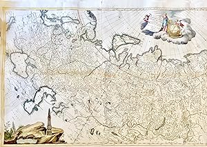
Tabula Geographica Generalis Imperii Russici
Publication Date: 1782
Seller: LUX IN ART di Ermanno Bertelli, Bologna, BO, Italy
Seller rating 5 out of 5 stars
Map
Condition: ottima. Incisione in rame con coloritura coeva. Grande carta raffigurante l'espansione dell'Impero Russo sotto il dominio di Caterina la Grande. comprendendo dalla Polonia alla penisola della Kam?atka e le Isole Aleutine. La mappa presenta tre splendidi cartigli: quello con il titolo � arricchito da un'allegoria della cartografia e della scoperta, quello contenete la scala di rappresentazione presenta un obelisco con una E incoronata da alloro (la prima lettera del nome di Caterina in Russo), e in basso a destra c'� una vignetta di Caterina stessa che osserva la mappa delle proprie conquiste durante la guerra Russo-Turca (1768-74). Bel esemplare in ottimo stato di conservazione. Coloured map i, total 650 x 1410mm. A fine large scale coloured map in three sheets conjoined, detailing the expanse of the Russian Empire under Catherine the Great, stretching from Poland to Kamchatka and the Aleutian Islands. There are three cartouches: the title is supported by embodiments of mapmaking and discovery, the scale has an obelisk with an 'E' crowned with laurels (the first letter of Catherine's name in Russian), and bottom right is a vignette of Catherine herself looking at a map of her conquests during the Russo-Turkish war (1768-74), aided by Mercury, a view of St Petersburg behind. This map was first published in St Petersburg in 1776. Formato: 143x735mm.
-

Tabula Geographica Generalis Imperii Russici.
Publication Date: 1782
Seller: Altea Antique Maps, London, United Kingdom
Association Member: ABA ILAB PBFA
Seller rating 5 out of 5 stars
Map
US$ 4,011.24
US$ 46.20 shipping
Ships from United Kingdom to U.S.A.Quantity: 1 available
Add to basketVenice: Remondini, 1782. Coloured. Three sheets conjoined, total 650 x 1410mm. A fine large scale map detailing the expanse of the Russian Empire under Catherine the Great, stretching from Poland to Kamchatka and the Aleutian Islands. There are three cartouches: the title is supported by embodiments of mapmaking and discovery; the scale has an obelisk with an 'E' crowned with laurels (the first letter of Catherine's name in Russian); and bottom right is a vignette of Catherine herself looking at a map of her conquests during the Russo-Turkish war (1768-74), aidedd by Mercury, a view of St Petersburg behind. This map was first published in St Petersburg in 1776.