
Order Total (1 Item Items):
Shipping Destination:

Valk Frederick (3 results)
Skip to main search results
Search filters
Product Type
- All Product Types
- Books (1)
- Magazines & Periodicals (No further results match this refinement)
- Comics (No further results match this refinement)
- Sheet Music (No further results match this refinement)
- Art, Prints & Posters (No further results match this refinement)
- Photographs (No further results match this refinement)
- Maps (1)
- Manuscripts & Paper Collectibles (1)
Condition Learn more
- New (No further results match this refinement)
- As New, Fine or Near Fine (1)
- Very Good or Good (No further results match this refinement)
- Fair or Poor (No further results match this refinement)
- As Described (2)
Binding
- All Bindings
- Hardcover (No further results match this refinement)
- Softcover (1)
Collectible Attributes
- First Edition (1)
- Signed (No further results match this refinement)
- Dust Jacket (No further results match this refinement)
- Seller-Supplied Images (3)
- Not Print on Demand (3)
Language (1)
Free Shipping
Seller Location
Seller Rating
-

SHYLOCK FOR A SUMMER
Published by Cassell, London, 1958
Seller: Kay Craddock - Antiquarian Bookseller, Melbourne, VIC, Australia
Association Member: ANZAAB ILAB
Seller rating 5 out of 5 stars

First Edition
First Edition. The story of one year (1954-5) in the life of Frederick Valk. With notes by Tyrone Guthrie and Donald Davis. Pp. xvi+134, frontispiece, 8 plates, list of productions, index; price-clipped dust wrapper, edges a trifle rubbed; a little light foxing; Cassell, London, 1958. First edition.
-
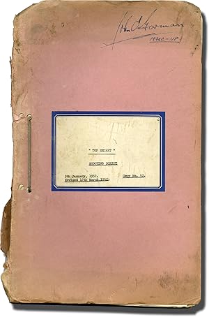
Mr. Potts Goes to Moscow (Original screenplay for the 1952 film)
Published by Mario Zampi Productions / Stratford Pictures, London, 1952
Seller: Royal Books, Inc., ABAA, Baltimore, MD, U.S.A.
Seller rating 5 out of 5 stars
Manuscript / Paper Collectible
Shooting script for the 1952 film. Copy belonging to makeup artist John O'Gorman, with his signature on the front wrapper and annotations throughout in manuscript ink and pencil. Known in England as "Top Secret," a British plumber travels abroad for vacation with plans he believes to be for his new sanitation invention, but are actually blueprints for a top secret weapon. He is contacted by the Soviet government to do research on what he believes to be plumbing. Set in Moscow. Pink titled wrappers, noted as SHOOTING SCRIPT on the front wrapper, rubber-stamped copy No. 52, dated March 12, 1952. Title page present, dated January 2, 1952, noted as SHOOTING SCRIPT, with credits for screenwriters Jack Davies, and Michael Pertwee. 113 leaves, with last page of text numbered 114. Mimeograph duplication. Pages Very Good plus, wrapper Very Good plus bound with string binding.
-

Orbis Terrarum Nova et Accurata Tabula
Published by Amsterdam, 1690
Seller: HS Rare Books, ILAB/ABAA, New York, NY, U.S.A.
Seller rating 4 out of 5 stars

Map
Condition: Fine. Unrecorded wall map of the World from the Golden Age of Dutch Cartography De Wit, Frederick; Valk, Gerard. Orbis Terrarum Nova et Accurata Tabula. N.d. [ca. 1690]. Amsterdam. Four sheets, 840 mm x 920 mm once joined. Joined and mounted on linen, fine hand colour. Finely preserved and previously unknown 4-sheet double hemisphere map of the World, intended to be displayed by a 17th Century Aristocrat. In the 17th Century, at the height of the Golden Age of Dutch Cartography, Dutch published wall maps became an important decorating statement for aristocrats and wealthy traders in Western Europe. Artists such as Jan Vermeer captured the importance of these wall maps as objects of art in a number of his most famous paintings, such as his The Art of Painting. Among the most important of the late 17th Century mapmakers was Frederick De Wit of Amsterdam. De Wit continued the tradition of remarkable wall maps by Willem Blaeu, Nicholas Visscher and others, including several wall maps of the world in 4, 8 and 12 sheets, many of which would be copied and re-issued by the great Italian mapmakers of the late 17th Century, including Stefano Scholar, Pietro Todeschi and Guiseppe Longhi. Because of the size of these maps and use as objects of art, to be displayed prominently in the homes of the wealthy and ruling elite of Europe, very few examples of these maps have survived until modern times and when such maps survive, they are most typically in poor condition or heavily restored. In modern times, such 17th Century wall maps are highly coveted. The present map is an unrecorded variant of one of Frederick De Wit's multi-sheet masterpieces, published by Gerard Valk, one of the leading map publishers and engravers in Amsterdam at the end of the 17th Century. Known primarily for fine engraving and high artistic quality, Valk's work is among the finest from the latter part of the Golden Age of Dutch Cartography. The map consists of a twin hemisphere world map, together with two polar projections. Surrounding the map are personifications of the four seasons (from upper left to lower right): spring, a dancing bear breasted Persephone is garlanded with spring flowers; summer, Ceres brings in the wheat harvest; autumn, Dionysis accompanied by satyrs and cherubs, collects the grape harvest, and adorn a herm with vines; winter, represented by strong man carrying a stick, Boreas the north wind can be seen blowing, whilst cherubs gut fish. The map is based upon Frederick de Wit's terrestrial world map executed in about 1670-1680 (Shirley 451). This magnificent map must have been published between 1690 and 1700, as the imprint which appears on the pedestal of the garlanded herm in the lower left plainly gives the place as 'op d'Dam inde Wackeren hont.' Gerard Valck and his family moved into this house (where the Hondius family had previously lived) in about 1690. A latest possible date of approximately 1700 is provided by a variant of this map which includes the name of Leonardus, Gerard's son, and, although smaller, contains new details such as the supposed Mer Glaciale in northernmost America (Shirley 638). Both this later map, an earlier Valck world map (Shirley 531 & 532, giving incorrect date of c.1686). The present example is a remarkable survival, especially in such magnificient condition. The condition is, without question, the finest we have ever seen for a multi-sheet wall map of the 17th Century. Full description available upon request.